
Mori Atlas logo
Nature reserveNachtweide von Patershausen

Mapping the habitats and protected terrain of this significant Hesse nature conservation area

Nachtweide von Patershausen Nature Reserve in Hessen: A Detailed Geographic and Landscape Atlas

(Naturschutzgebiet Nachtweide von Patershausen)

Nachtweide von Patershausen serves as a crucial protected landscape within the Offenbach district of Hessen, Germany. This 17.77 hectare nature reserve provides an essential mosaic of meadows, orchard trees, forest patches, and historical carp ponds. The area remains highly significant for regional conservation, specifically for preserving nutrient-poor grassland habitats and supporting local amphibian populations within the southern Rhine-Main landscape.

nature reservemeadowspondscarp pondshedgerowsorchard trees
A flat-style vector illustration shows a marshy wetland with tall grasses in the foreground, calm pools of water in the midground, and rugged mountains under a sunset sky in the background.

Nachtweide von Patershausen

Nature reserve

Park overview

Structured park overview, official facts, and landscape profile for Nachtweide von Patershausen

Nachtweide von Patershausen park facts, protected area profile, and essential visitor context

Review the core facts for Nachtweide von Patershausen, including designation, size, terrain, visitor scale, habitats, and operating context in one park-focused overview.

About Nachtweide von Patershausen

Nachtweide von Patershausen is a compact yet ecologically rich nature reserve in Hesse, Germany. It sits in the Landkreis Offenbach, immediately to the south of the town of Heusenstamm and in direct contact with the historic Hofgut Patershausen estate. Although covering only about 17.77 hectares, the reserve contains a remarkable variety of habitat types within a very small footprint.

The site has been under formal protection since 29 July 1987 and is classed as an IUCN Category IV area, a designation reserved for habitats and species management zones. Its management falls under the lower nature conservation authority of the Kreis Offenbach, reflecting its role as a locally significant protected landscape rather than a large national park-scale area.

What distinguishes the Nachtweide is not its size but its habitat diversity. Meadows, fallow ground, hedgerows, scattered orchard trees, small woodland patches, and a network of former carp ponds create a classic cultural landscape mosaic. This combination of open and wet habitats, interspersed with shrubs and trees, supports a wide range of species and gives the reserve its particular conservation value. For residents of Heusenstamm and visitors to the Rhine-Main area, the Nachtweide also functions as a popular local recreation area, appreciated both for its scenery and its accessibility.

Quick facts and research context for Nachtweide von Patershausen

Nachtweide von Patershausen is a Hessian nature reserve located south of the town of Heusenstamm in the Landkreis Offenbach. It has been protected since 29 July 1987 under the identifier NSG 1438012 and is listed in the World Database on Protected Areas with the WDPA ID 164746.

The reserve covers roughly 17.77 hectares and falls under IUCN Category IV, meaning it is managed primarily to conserve specific habitats and species. Its composition includes meadows, fallow fields, hedges, orchard trees, woodland, and historic carp ponds, making it a compact but ecologically varied protected landscape in the Rhine-Main region.

Protection and recognition

Examine documented conservation data and official protected area records for Nachtweide von Patershausen.

Nachtweide von Patershausen Protection Status and Designated Area Record

Nachtweide von Patershausen maintains formal documentation regarding protected area designation and management oversight. Review structured conservation metrics and verified recognition records within the international database.

Protection details

WDPA ID
164746
Park context

Deeper park guide and search-rich context for Nachtweide von Patershausen

Nachtweide von Patershausen history, landscape, wildlife, and travel context

Explore Nachtweide von Patershausen through its history, landscape character, ecosystems, wildlife, conservation priorities, cultural context, and seasonal travel timing in a structured park guide built for atlas discovery and search intent.

Why Nachtweide von Patershausen stands out

The reserve is especially known for its significant population of the European tree frog, a species that is endangered in many parts of Central Europe, as well as for the regional rarity of its nutrient-poor grassland (Magerrasen) habitats. Together these elements give the small site an outsized importance for amphibian and grassland conservation in the Hesse area around Heusenstamm.
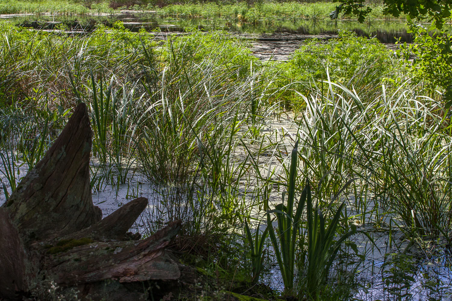
A close-up view of a pond with reeds and long grasses growing in shallow, murky water. A large, weathered tree stump sits in the foreground on the left, and lush greenery fills the background.
A shallow pond and wetlands area at Nachtweide von Patershausen.

Nachtweide von Patershausen history and protected-area timeline

The Nachtweide von Patershausen received formal nature protection status on 29 July 1987, when it was designated as a Naturschutzgebiet under Hessian conservation law. Its protection was motivated by the need to preserve both the botanical and zoological value of the site's meadows, fallow land, hedgerows, orchard trees, woodland, and historic carp ponds.

The name Nachtweide itself has older cultural roots; a Nachtweide historically refers to a type of communal grazing area used under specific traditional arrangements. Today the term describes a place that retains the character of an old working agricultural landscape, even as its primary function has shifted from grazing to conservation and recreation. Since its designation, the reserve has been integrated into the broader recreation area around Heusenstamm, and the adjacent Hofgut Patershausen estate remains a closely linked cultural landmark.

Nachtweide von Patershausen landscape and geographic character

The landscape of Nachtweide von Patershausen is a low-lying mosaic of habitats typical of the southern Rhine-Main region. Open meadows, dry nutrient-poor grassland patches, and areas of fallow land form the base layer, broken up by hedgerows, lines of orchard trees, and small woodland stands. These varied elevations of vegetation create a richly textured small-scale landscape.

A distinctive feature of the terrain is the network of former carp ponds, still holding water as small still pools or ponds, including the site known locally as the pond in the Nachtweide. These ponds soften the openness of the meadows and add reflectiveness and moisture to the landscape. The reserve borders directly on the Hofgut Patershausen estate, linking the protected area to a traditional agricultural and built environment.

Nachtweide von Patershausen ecosystems, habitats, and plant life

Ecologically, the Nachtweide is defined by the close interplay of open grassland, scrub, and water. The Magerrasen, or nutrient-poor dry grassland, found here is described as regionally unique and represents one of the botanical highlights of the reserve. These dry, species-rich swards contrast with the wetter vegetation around the ponds and along the margins of the woodland, producing a layered habitat mosaic.

Hedgerows and scattered orchard trees provide important structural diversity, offering shelter, food sources, and dispersal corridors for many species. Patches of woodland broaden the habitat spectrum further, while the disused carp ponds create valuable open-water and wetland niches. Together, these elements form an unusually rich ecological matrix for a site of this size.

Nachtweide von Patershausen wildlife and species highlights

The wildlife significance of Nachtweide von Patershausen rests above all on its amphibians, especially the European tree frog. The reserve hosts a notably large population of this endangered species, making it a key locality for tree frog conservation in the region.

The combination of ponds, meadows, hedgerows, and woodland supports a wider community of fauna typical of mixed cultural landscapes, including invertebrates associated with the dry grasslands and the wet margins around the ponds. The retained orchard trees and hedgerows also provide nesting and foraging habitat for a range of smaller vertebrates and insects, contributing to the overall biodiversity of the protected area.

Nachtweide von Patershausen conservation status and protection priorities

The primary conservation aim of the reserve is to preserve and sustainably improve both the zoological and botanical value of its habitats. Protection covers meadows, fallow land, hedgerows, orchard trees, woodland, and former carp ponds, with the objective of maintaining the site's role as a refuge for rare and endangered species.

The reserve's conservation importance is reinforced by the presence of the European tree frog population and by the regionally unique Magerrasen grasslands, both of which elevate the site beyond its modest size. Classified as an IUCN Category IV Habitat/Species Management Area, Nachtweide von Patershausen represents a focused management approach: a small area intensively protected for its particular habitats and species rather than for its broader scenic or wilderness qualities.

Nachtweide von Patershausen cultural meaning and human context

The Nachtweide has roots in older agricultural traditions; the term Nachtweide itself refers to a historic form of communal grazing land. The reserve also borders the Hofgut Patershausen, a traditional estate that gives the area its long-standing cultural identity. Today, while the primary function of the land is conservation, it remains integrated into the local cultural fabric of Heusenstamm as a familiar landscape and a popular recreational destination.

Top sights and standout views in Nachtweide von Patershausen

The Nachtweide stands out for packing an exceptional variety of habitats, meadows, fallow land, hedges, orchard trees, woodland, and former carp ponds, into just under 18 hectares. Within this small area lies one of the more significant European tree frog populations in the region and a rare example of nutrient-poor grassland that is described as regionally unique.

For visitors and locals, the reserve combines ecological interest with recreational value, offering scenic ponds, varied vegetation, and easy walking near the town of Heusenstamm, all anchored by its long-standing association with the neighboring Hofgut Patershausen.

Best time to visit Nachtweide von Patershausen

Spring and early summer are particularly rewarding periods to visit, when amphibians are most active around the ponds, orchard trees are in blossom, and the meadows and dry grasslands show their richest floral display. Late spring also tends to be the most active period for tree frog presence.

Warmer months in general are suitable for enjoying the reserve's mix of open and shaded habitats, while the network of paths near the Hofgut Patershausen makes the area accessible for short walks year-round. Cooler seasons still offer quiet enjoyment of the landscape, though wildlife viewing and floral interest will be reduced compared with late spring.

Monthly climate preview

Long-term temperature and precipitation patterns sampled from representative point measurements

Nachtweide von Patershausen Climate Normals and Monthly Weather Records

Representative point measurements for Nachtweide von Patershausen capture twelve-month temperature averages alongside daily precipitation rates from NASA climatology records. Reviewing the complete monthly profile provides detailed context on long-term thermal progression and seasonal moisture distribution.
Annual mean10 °C
0 °C21 °C
Jan
Feb
Mar
Apr10°
May14°
Jun18°
Jul21°
Aug20°
Sep15°
Oct10°
Nov
Dec
Warmest month
July

20.6 °C

Coolest month
January

0.2 °C

Wettest month
July

2.2 mm/day

Driest month
April

1.4 mm/day

Park location guide

Geography guide, regional context, and park location map for Nachtweide von Patershausen

Nachtweide von Patershausen park geography, regions, and map view in Germany

Understand where Nachtweide von Patershausen sits in Germany through a broader geographic reading of the surrounding landscape, nearby location context, and its mapped position within the national park landscape.

How Nachtweide von Patershausen fits into Germany

Germany is a federal republic in Western and Central Europe with a population of over 83 million across sixteen constituent states. It is Europe's largest economy by nominal GDP and a major global exporter and importer. The capital is Berlin, and the country borders Denmark, Poland, Czech Republic, Austria, Switzerland, France, Luxembourg, Belgium, and the Netherlands.

Wider geography shaping Nachtweide von Patershausen in Germany

Germany is located in Western and Central Europe, spanning 357,022 km². It borders Denmark to the north, Poland and the Czech Republic to the east, Austria and Switzerland to the south, and France, Luxembourg, Belgium, and the Netherlands to the west. The country has coastlines on the Baltic Sea and North Sea to the north, with the Alps located in the southern region.

Map view of Nachtweide von Patershausen

Use this park location map to pinpoint Nachtweide von Patershausen in Germany, understand its exact geographic position, and read its mapped placement within the surrounding landscape more clearly.

Pigeon | © OpenStreetMap contributors

Location context for Nachtweide von Patershausen

Hessen

Visualizing the habitats, meadows, and carp ponds of Hesse

Nachtweide von Patershausen Photos and Protected Area Landscapes

Visual records capture the low-lying terrain, nutrient-poor grasslands, and historic water bodies shaping Nachtweide von Patershausen. Exploring protected area imagery clarifies the rare mosaic of habitats supporting vulnerable amphibian populations across the Rhine-Main region.

A close-up view of a pond with reeds and long grasses growing in shallow, murky water. A large, weathered tree stump sits in the foreground on the left, and lush greenery fills the background.

Park atlas

Compare regional conservation landscapes and nearby natural reserves across Hesse.

Parks Near Nachtweide von Patershausen: Explore Surrounding Protected Areas

Browse protected areas and natural reserves situated near Nachtweide von Patershausen in the Rhine Main region. Expanding the geographic comparison reveals connected lowland habitats, regional wetland ecosystems, and similar cultural landscapes.
Nature reserveHessen
About 3.1 km away#1 closest

West

Luderbachaue von Dreieich: A Protected Floodplain Forest and Habitat in Hessen, Germany

Mapping the ecological geography of a significant lowland nature reserve

Spanning over 290 hectares, Luderbachaue von Dreieich serves as a major protected floodplain forest. The site preserves a diverse mosaic of oak, beech, and alder-ash woodlands that sustain rare fungal communities and old-growth timber, maintaining a vital green corridor in the urbanized Rhine-Main region.

Area
2.938 km²
Established
1996
IUCN
IV
Relief
Lowland
Watercolor painting of a green wetland landscape with trees, grasses, and distant rolling hills on a white background.
Nature reserveHessen
About 4.3 km away#2 closest

North

Erlensteg von Bieber Nature Reserve: Geographic Map and Protected Habitat Overview

Compact wetland and forest mosaic in the Hessen region

Erlensteg von Bieber preserves a rare concentration of habitat types within a small footprint. From its moist floodplain meadows and sedge wetlands to its drier forest glades and fallow fields, this reserve showcases vital conservation management in the Rhine-Main area of Germany.

Area
0.752 km²
Established
1996
IUCN
IV
Nature reserveHesse
About 4.8 km away#3 closest

Northeast

Im Woog von Hainstadt Nature Reserve: Regional Geography and Protected Landscape Atlas

Mapping floodplain habitats in the Lower Main plain of Hesse

Im Woog von Hainstadt is a structurally diverse nature reserve located in Hainstadt, Germany. The site protects a compact floodplain mosaic consisting of deciduous woodland, wet meadows, and dry grasslands on a former river meander. Adjacent to the Wildpark Alte Fasanerie, the reserve functions as a biodiversity hotspot, offering essential habitat within the developed eastern Lower Main plain landscape.

Area
0.142 km²
Established
1992
Relief
Lowland
Climate
Temperate
Nature reserveHessen
About 5.6 km away#4 closest

Northwest

Bruch von Gravenbruch Nature Reserve: Geographic Profile and Protected Wetland Mapping

Hessen lowland moor and wetland habitat analysis

Examine the detailed terrain of Bruch von Gravenbruch, a notable nature reserve in Hessen characterized by its high groundwater table and intricate moisture-dependent ecosystems. The area serves as a key reference for studying lowland moor development, bog woodland structure, and the spatial distribution of protected wetland meadows across the regional landscape.

Area
0.932 km²
Established
1984
IUCN
IV
A watercolor painting of a flat, marshy landscape with soft green trees, grassy plains, and subtle pink tones against a white background.
Nature reserveHessen
About 5.7 km away#5 closest

Southeast

Rodauwiesen bei Rollwald Nature Reserve: Protected Lowland Landscapes in Hessen

Mapping floodplain meadows and reed habitats in the Rodau valley

The Rodauwiesen bei Rollwald nature reserve protects a distinct 32-hectare stretch of lowland floodplain along the Rodau stream in Hessen. This site serves as a vital green refuge, featuring expansive open grassland and significant common reed stands that mirror the historic character of the Untermainebene. Use this geographic reference to study the area's protected boundaries, hydrological terrain, and surviving wet meadow ecosystems within a rapidly developing urban corridor.

Area
0.327 km²
Established
1999
IUCN
IV
Relief
Lowland
A wide watercolor illustration depicting a green wetland landscape with reed beds, grasses, and distant hills under a pale sky.
Nature reserveHessen
About 6.9 km away#6 closest

Northeast

Gräbenwäldchesfeld von Hausen: Nature Reserve and Protected Wetland Landscape Geography

Mapping rare meadow ecosystems in the Hessen region

Gräbenwäldchesfeld von Hausen functions as a critical protected nature reserve, safeguarding species-rich wet meadows and moisture-dependent flora in the town of Obertshausen. This atlas entry details the site's role within the Landkreis Offenbach, focusing on the preservation of reed beds and marsh landscapes amidst a predominantly urbanized terrain.

Area
0.054 km²
Established
1990
IUCN
IV
Relief
Lowland
Nature reserveHessen
About 7 km away#7 closest

West

Oberwiesen von Sprendlingen Nature Reserve: Landscape and Protected Area Geography

Wet meadows and seminatural grassland in the Hessen region

Located near Dreieich, Oberwiesen von Sprendlingen occupies seventeen hectares of diverse terrain where flat plains meet rolling hills. This nature reserve protects a documented array of fen fragments, reed beds, and tall herb stands, functioning as an ecological bridge within the regional network of protected Hessen landscapes.

Area
0.17 km²
Established
1996
IUCN
IV
Relief
Lowland
Nature reserveLandkreis Offenbach
About 7.9 km away#8 closest

Southeast

Niederrodener Lache: A Protected Nature Reserve in Landkreis Offenbach, Germany

Brook-side habitat mosaic and regional landscape geography

Niederrodener Lache encompasses 124 hectares of protected woodland and grassland in the Landkreis Offenbach district. Centered on the Lache brook, the reserve hosts a dense interweaving of alder-fringed streams and varied meadow types. Its landscape profile provides a vital refuge for threatened vegetation and wetland biotopes within the suburbanizing Rhine-Main metropolitan area.

Area
1.246 km²
Established
1986
IUCN
IV

Common questions about visiting, size, designation, and location context for Nachtweide von Patershausen

Nachtweide von Patershausen FAQs for park facts, access, geography, and protected area context

Find quick answers about Nachtweide von Patershausen, including protected-area facts, park geography, trail and visitor context, and how the park fits into its surrounding country and regional landscape.
MoriAtlas Explorer

Continue Your Protected Areas Search Across the Global Atlas

Deepen your exploration by continuing the structured search for national parks and protected areas worldwide. Utilize the comprehensive filtering capabilities to compare different conservation landscapes and refine your understanding of global park geography. Discover more about the distribution and characteristics of protected natural areas.

Global natural geography