

Mori Atlas logo
Protected landscapeNassachtal

Understanding the catchment-wide conservation of the Nassach valley and surrounding Schurwald hill terrain.

Nassachtal Protected Landscape: Geography and Mapped Boundaries in Baden-Württemberg

(Landschaftsschutzgebiet Nassachtal)

Nassachtal represents a significant protected landscape in Baden-Württemberg, spanning over two thousand hectares across the Göppingen and Rems-Murr-Kreis districts. The area provides a cohesive natural framework centered on the entire Nassach stream catchment, characterized by a mosaic of forested slopes, meadow transitions, and valley-bottom stream corridors. This geography reflects the broader Swabian Keuper-Lias landscape, offering a vital network of local conservation zones that connect woodland habitats with the surrounding Schurwald uplands.

landscape protection areariver valleycatchment conservationSchurwaldSwabian hill countrymixed forest

Nassachtal

Protected landscape

Park overview

Structured park overview, official facts, and landscape profile for Nassachtal Landscape Protection Area

Nassachtal Landscape Protection Area park facts, protected area profile, and essential visitor context

Review the core facts for Nassachtal Landscape Protection Area, including designation, size, terrain, visitor scale, habitats, and operating context in one park-focused overview.

About Nassachtal Landscape Protection Area

Nassachtal is a mid-sized landscape protection area in the German state of Baden-Württemberg, focused on preserving the character of a complete small river valley in the Swabian hill country. Established in 1982, it belongs to Germany's category of Landschaftsschutzgebiete, which is broadly comparable to IUCN Category V protected landscapes. The protection area is significant not for its scale, but for the fact that it embraces the entire catchment of the Nassach, a tributary of the Fils river, together with the flanking slopes and adjacent natural areas.

Geographically, the protected area lies within the Schurwald und Welzheimer Wald natural region, which is part of the larger Swabian Keuper-Lias landscape belt that extends across central Baden-Württemberg. The terrain is shaped by the gently incised valley of the Nassach and by the forested uplands surrounding it, producing a mosaic of woodland, valley-bottom habitats, and small-scale agricultural land. The result is a characteristic Swabian valley landscape, with cultural and ecological value that goes beyond any single habitat type.

The protection area sits at the interface of two administrative districts, the Landkreis Göppingen and the Rems-Murr-Kreis. Within or adjacent to its boundaries lie the municipalities of Ebersbach an der Fils, Wangen, Uhingen, and the town of Schorndorf. This administrative overlap also creates a regional identity: Nassachtal functions simultaneously as a local recreational area, a habitat connector, and a piece of the larger protection network that includes the Bärentobel nature reserve and the Schurwald FFH area.

From a conservation perspective, the most important role of Nassachtal is that of a near-natural landscape anchor. By protecting the full catchment of the Nassach, it provides a buffer around the Bärentobel nature reserve, contributes habitat to the Schurwald FFH area, and secures the scenic and recreational character of the valley for the surrounding communities. Its profile is therefore practical and integrative rather than spectacular: it represents the kind of working-valley protection that defines much of Germany's regional conservation geography.

Quick facts and research context for Nassachtal Landscape Protection Area

Nassachtal is a landscape protection area in Baden-Württemberg, Germany, designated under the IUCN Category V framework (Protected Landscape/Seascape). It was established by decree of the Landratsamt Göppingen on 6 September 1982, with the regulation also applying to the Rems-Murr-Kreis. The protection area covers approximately 2166.6 hectares, divided between two districts: about 995 hectares in the Landkreis Göppingen and about 1171.6 hectares in the Rems-Murr-Kreis.

The protected area lies within the natural region of Schurwald und Welzheimer Wald, part of the wider Swabian Keuper-Lias terrain. Its boundaries follow the complete catchment of the Nassach, a tributary of the Fils. Administratively, the protection area falls within the municipalities of Ebersbach an der Fils, Wangen, Uhingen, and Schorndorf, and is jointly administered by both districts. The area also contains the 9.8-hectare Bärentobel nature reserve and overlaps with parts of the Schurwald FFH site.

Protection and recognition

Terrestrial protection framework, management scope, and verified registry data

Nassachtal Protection Status and Documented Protected Area Records

Nassachtal maintains a documented terrestrial protection scope within official conservation registries and spatial databases. Verified designation metrics outline the administrative framework governing this protected natural landscape.

Protection details

Protection scope
Terrestrial
Transboundary protection
No
WDPA ID
323123
Park context

Deeper park guide and search-rich context for Nassachtal Landscape Protection Area

Nassachtal Landscape Protection Area history, landscape, wildlife, and travel context

Explore Nassachtal Landscape Protection Area through its history, landscape character, ecosystems, wildlife, conservation priorities, cultural context, and seasonal travel timing in a structured park guide built for atlas discovery and search intent.

Why Nassachtal Landscape Protection Area stands out

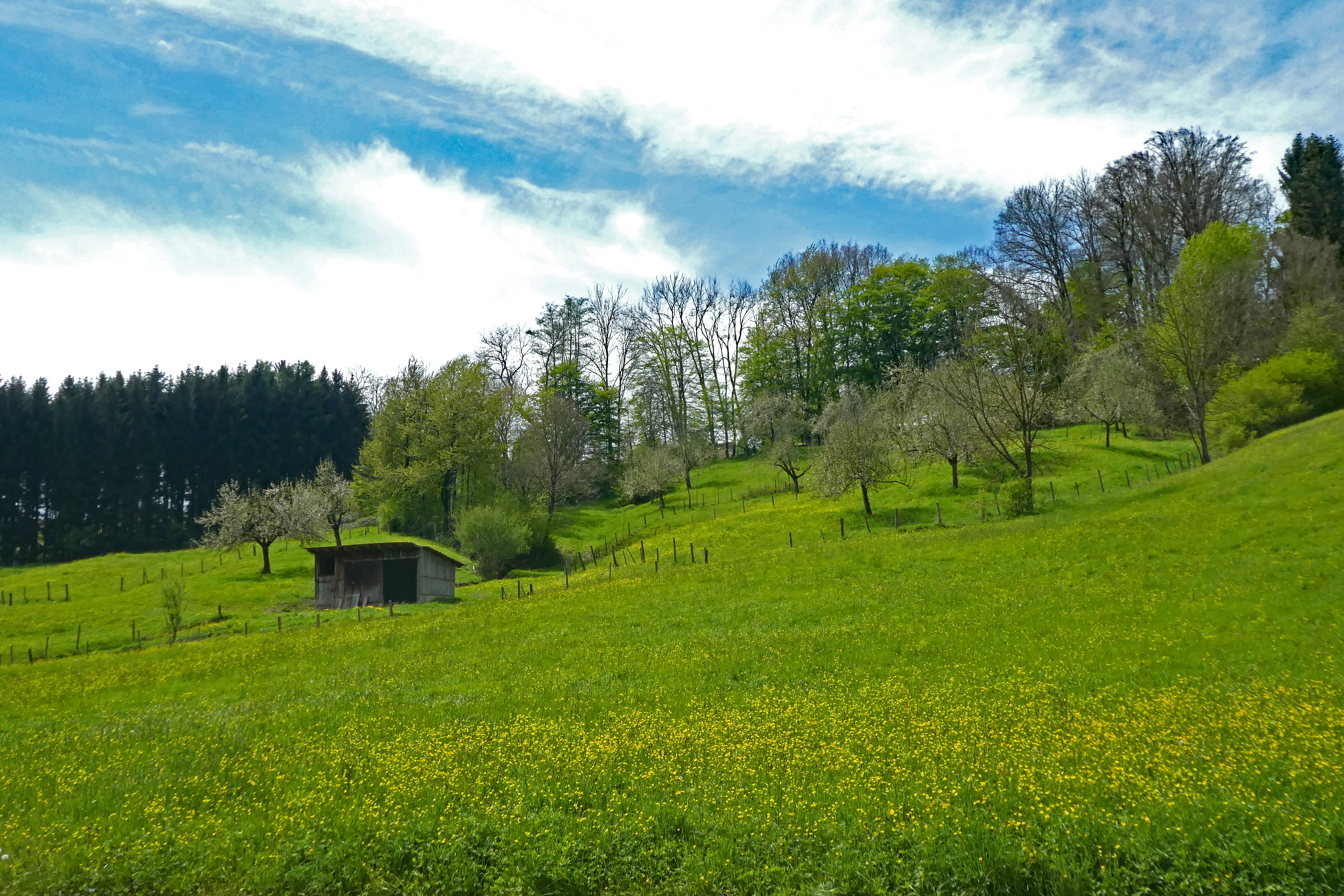
Nassachtal is best known for protecting an entire small river catchment, the Nassach valley, as a near-natural and ecologically coherent landscape. Rather than a single dramatic landmark, its identity lies in the continuity of the valley system: the stream corridor, the wooded slopes of the Schurwald, and the transition zones where forest, meadow, and valley bottom meet. The area's protection status also reflects the broader importance of conserving representative valley landscapes in the Swabian hill country west of Stuttgart.
Nassachtal Landscape Protection Area
Landscape protection area within the Nassachtal valley

Nassachtal Landscape Protection Area history and protected-area timeline

Nassachtal was formally designated as a landscape protection area on 6 September 1982, through a regulation issued by the Landratsamt Göppingen, which also applies within the Rems-Murr-Kreis. The establishment was part of a broader wave of formal landscape protection designations in Baden-Württemberg during the late twentieth century, aimed at safeguarding representative Swabian valley landscapes against fragmentation, land-use change, and loss of near-natural character.

From the outset, the area was framed around the idea of protecting a complete catchment. Rather than drawing boundaries around isolated fragments, the original designation embraced the entire Nassach valley system, including its slopes and adjacent natural areas. This catchment-wide approach also gave the protection area immediate ecological relevance: it fully encloses the smaller Bärentobel nature reserve, and parts of its territory overlap with what later became the Schurwald FFH (Fauna-Flora-Habitat) site.

Since 1982, the area has continued to be managed jointly by the Landkreis Göppingen and the Rems-Murr-Kreis. Its institutional profile has remained relatively stable, functioning as a long-standing local conservation framework rather than a flagship national designation. Over the decades, its role has been reinforced by inclusion in the broader Schurwald habitat network, which links landscape protection, nature reserve, and European habitat designations into an integrated regional conservation landscape.

Nassachtal Landscape Protection Area landscape and geographic character

The landscape of Nassachtal is shaped by the valley of the Nassach stream and the surrounding Schurwald hill country. The terrain is typical of the eastern edge of the Swabian Keuper-Lias belt: gently incised valleys cut into forested uplands, with woodland covering much of the slopes and a narrower mosaic of valley-bottom habitats along the stream. The Nassach itself is a relatively small watercourse, a tributary of the Fils, but the protection area is defined around the entire catchment rather than a single section of the river.

The valley follows the broader geological rhythm of the Schurwald, with hilltops, slopes, and valley floors producing a layered landscape structure. Wooded ridges dominate the upper elevations, while the valley floor narrows and widens in the characteristic pattern of small Swabian streams. Where the slopes meet the valley bottom, transitions between forest, meadow, and small-scale agricultural land create a varied local scenery that is central to the area's identity.

The protection area sits within a network of related landscapes: the Schurwald forest uplands to the south and west, the broader Welzheimer Wald to the east, and the Fils valley corridor nearby. This positioning gives Nassachtal a transitional character, linking more intensively used lowland landscapes with the larger forest landscapes of the region, and contributing to the visual coherence of the wider Schurwald und Welzheimer Wald natural region.

Nassachtal Landscape Protection Area ecosystems, habitats, and plant life

Ecologically, Nassachtal is defined by its position within the Schurwald und Welzheimer Wald natural region, an area classified as part of the larger Swabian Keuper-Lias landscape. The catchment-wide protection of the Nassach valley produces a mosaic of habitats rather than any single dominant ecosystem. Forested slopes cover the majority of the area, while the valley floor supports a mix of stream-side vegetation, meadows, and small-scale agricultural land that increases habitat diversity at the edges of the woodland.

The stream corridor itself is a key ecological element. By protecting the full Nassach catchment, the designation secures not only the main channel but also the smaller tributaries, seepage zones, and wet depressions that connect to it. These features are particularly important for amphibians, invertebrates, and plant communities associated with near-natural small streams in the Swabian hill country.

The relationship between Nassachtal and surrounding protected areas strengthens its ecological function. The Bärentobel nature reserve lies fully inside the landscape protection area, and parts of the territory also fall within the Schurwald FFH site. This creates an overlapping system of protection categories that supports habitat continuity between landscape-level, nature reserve-level, and European habitat-level conservation. The result is an area whose ecological value comes less from rarity and more from integrity at the catchment scale.

Nassachtal Landscape Protection Area wildlife and species highlights

Although the available documentation does not provide a detailed species inventory, Nassachtal's ecological profile suggests a fauna typical of near-natural deciduous and mixed forest streams in the Swabian hill country. The wooded slopes of the Schurwald provide habitat for a range of forest-dwelling species, while the valley-bottom mosaic of meadows, hedges, and small watercourses supports a separate set of open-land and wetland-associated fauna. The presence of the Bärentobel nature reserve and the overlap with the Schurwald FFH site indicate that the area contributes to broader regional efforts to protect forest, stream, and valley-bottom fauna across the Schurwald.

Nassachtal Landscape Protection Area conservation status and protection priorities

Nassachtal belongs to the IUCN Category V framework for protected landscapes, reflecting its role as a working landscape where ecological, scenic, and recreational values are maintained together. Its conservation purpose focuses on preserving the near-natural character of the Nassach catchment, retaining the diversity of landscape elements that define the valley, and ensuring the area continues to function as a habitat and a place for low-intensity recreation.

The protection area's most distinctive conservation contribution is its catchment-wide logic. By drawing boundaries around the entire Nassach basin rather than arbitrary sections of the valley, it secures the ecological connectivity of forest, slope, and stream habitats. This approach also creates a protective buffer around the Bärentobel nature reserve, which is fully enclosed within the landscape protection area, and supports the integrity of parts of the Schurwald FFH area.

At the regional level, Nassachtal functions as one component in a layered conservation network spanning the Schurwald and Welzheimer Wald. Its protection adds to a system in which landscape protection areas, nature reserves, and European habitat designations reinforce one another, helping maintain habitat continuity across administrative boundaries and across the broader Swabian hill country west of Stuttgart.

Top sights and standout views in Nassachtal Landscape Protection Area

Nassachtal's defining strength is its catchment-wide protection of the Nassach valley and surrounding Schurwald terrain, securing a coherent near-natural landscape at the scale of an entire small river basin. The area combines forested slopes, stream-side habitats, and a network of small land-use mosaics in a setting typical of the eastern Swabian hill country. Within its boundaries, the Bärentobel nature reserve adds a stricter layer of habitat protection, and its overlap with the Schurwald FFH area connects it to European-level habitat conservation efforts.

Best time to visit Nassachtal Landscape Protection Area

The character of Nassachtal is strongly shaped by the seasonal rhythm of a small valley in the Swabian hill country. Spring brings fresh green growth along the stream corridors and the lower slopes, while summer highlights the full canopy of the Schurwald forests and active streamside vegetation. Autumn is typically the most visually expressive season in this kind of mixed woodland landscape, with broadleaf color contrasts across the valley, while winter offers quieter, more open views along the Nassach and across the ridges of the Schurwald. Because the area is a working landscape with habitats rather than a high-elevation park, most seasons are suitable for low-intensity walks, with the choice depending primarily on whether the visitor prefers forest interior, open valley views, or seasonal color.

Monthly climate preview

Long term representative averages for temperature and precipitation rhythm across the park terrain

Nassachtal Climate Normals and Measured Annual Temperature Patterns

Nassachtal records measured long term monthly temperatures ranging from sub zero winter minimums to warm summer maximums alongside steady year round precipitation. Examining the complete twelve month climate profile reveals detailed monthly fluctuations and baseline environmental norms across the protected area.
Annual mean8 °C
-1 °C18 °C
Jan-1°
Feb
Mar
Apr
May13°
Jun16°
Jul18°
Aug18°
Sep14°
Oct
Nov
Dec
Warmest month
July

18.2 °C

Coolest month
January

-1.1 °C

Wettest month
July

3.2 mm/day

Driest month
February

1.7 mm/day

Park location guide

Geography guide, regional context, and park location map for Nassachtal Landscape Protection Area

Nassachtal Landscape Protection Area park geography, regions, and map view in Germany

Understand where Nassachtal Landscape Protection Area sits in Germany through a broader geographic reading of the surrounding landscape, nearby location context, and its mapped position within the national park landscape.

How Nassachtal Landscape Protection Area fits into Germany

Germany is a federal republic in Western and Central Europe with a population of over 83 million across sixteen constituent states. It is Europe's largest economy by nominal GDP and a major global exporter and importer. The capital is Berlin, and the country borders Denmark, Poland, Czech Republic, Austria, Switzerland, France, Luxembourg, Belgium, and the Netherlands.

Wider geography shaping Nassachtal Landscape Protection Area in Germany

Germany is located in Western and Central Europe, spanning 357,022 km². It borders Denmark to the north, Poland and the Czech Republic to the east, Austria and Switzerland to the south, and France, Luxembourg, Belgium, and the Netherlands to the west. The country has coastlines on the Baltic Sea and North Sea to the north, with the Alps located in the southern region.

Map view of Nassachtal Landscape Protection Area

Use this park location map to pinpoint Nassachtal Landscape Protection Area in Germany, understand its exact geographic position, and read its mapped placement within the surrounding landscape more clearly.

Pigeon | © OpenStreetMap contributors

Location context for Nassachtal Landscape Protection Area

Baden-Württemberg

Visual reference guide to the wooded valley terrain and river catchment habitats

Nassachtal Landscape Photos and Protected Valley Scenery

Visual documentation reveals the forested slopes, stream corridors, and valley floor mosaics that define the protected landscape of Nassachtal. Exploring these photographic records clarifies the topography, habitat transitions, and conservation character across the Schurwald hill country.

Nassachtal Landscape Protection Area

Park atlas

Compare regional protected areas and connected terrain across the Swabian hill country

Parks Near Nassachtal: Explore Other Protected Landscapes and Valley Reserves

Visitors reviewing Nassachtal can browse adjacent protected areas and nearby valley reserves within the Schurwald uplands. Examining these surrounding conservation zones provides broader geographic context for the wooded hill country and river catchment networks of Baden-Württemberg.
Protected landscapeBaden-Württemberg
About 6.5 km away#1 closest

Northwest

Ottilienberg Protected Landscape: Geomorphological Identity and Regional Mapping

A distinct Keuper outlier hill within Baden-Württemberg

The Ottilienberg protected landscape is a landmark Keuper Zeugenberg situated on the southern outskirts of Schorndorf. This compact area features a striking oak-dominated woodland crest and traditional orchard meadows, serving as a key example of a preserved cultural-historic landscape in southwestern Germany.

Area
0.083 km²
Established
1968
IUCN
V
Relief
Upland
Protected landscapeBaden-Württemberg
About 9.4 km away#2 closest

South

Wolfschlugen Protected Landscape: Geography and Atlas of the Filder Plateau

Mapped protected lands in Baden-Württemberg Germany

Wolfschlugen stands as a significant protected area in the Esslingen district, preserving traditional orchard meadows and open agricultural plains. The area offers a detailed study of regional land use, featuring a mosaic of meadow habitats and stream-side wetlands essential to the Filder plateau landscape character.

Area
0.51 km²
Established
1985
IUCN
V
Protected landscapeBaden-Württemberg
About 9.5 km away#3 closest

Southwest

Notzingen Protected Landscape: Mapping the Voralb Foothills and Swabian Alb Terrain

Regional protected area analysis in Landkreis Esslingen

Notzingen represents a coherent protected landscape composed of three parcels near the Swabian Alb foothills. The area is defined by a delicate intersection of stream-side riparian habitats and traditional Streuobstwiesen orchard meadows. This atlas-focused entry provides spatial context for understanding how these protected lands maintain the character of the southern German countryside.

Area
3.15 km²
Established
1989
IUCN
V
Relief
Upland
Protected landscapeBaden-Württemberg
About 11 km away#4 closest

South

Ohmden-Holzmaden Protected Landscape: Swabian Alb Foothill Mapping

A diverse mosaic of traditional orchards and stream valleys

Ohmden-Holzmaden encompasses a vital protected landscape in the Esslingen district, defined by the Trinkbach, Seebach, and Aubach valleys. This geography of traditional orchards, meadows, and hedgerows maintains an open, structured rural habitat that serves as a critical refuge within the broader Swabian Alb foothill region of Germany.

Area
3.111 km²
Established
1993
IUCN
V
Relief
Upland
Protected landscapeLandkreis Esslingen
About 12 km away#5 closest

West

Wernau (Neckar) Protected Landscape: Geographic Overview and Mapped Cultural Terrain

Landscape protection area within the Landkreis Esslingen region

Trace the boundaries of the Wernau (Neckar) protected landscape, an ecologically significant mosaic of meadow orchards, riparian vegetation, and small woodlands. Situated in the Landkreis Esslingen of Baden-Württemberg, this area functions as a critical buffer zone that maintains the continuity of local habitats between the Filder plain and the Swabian Alb foothills.

Area
2.27 km²
Established
1995
IUCN
V
Protected landscapeBaden-Württemberg
About 14 km away#6 closest

Northwest

Zipfelbachtal, Korber Kopf, Buocher Höhe, Remstalhänge, Ramsbachtal und Grafenberg Protected Landscape Map

Mapping the Keuper cultural landscape of Baden-Württemberg

Study the intricate topography and land use patterns of this expansive protected area in the Rems-Murr-Kreis. The region preserves a variety of habitats, including vineyard slopes, traditional Streuobst orchards, and forested ravines, providing a clear window into the natural and agricultural heritage of the eastern Stuttgart region.

Area
20.856 km²
Established
1968
IUCN
V
Relief
Upland
Protected landscapeBaden-Württemberg
About 15 km away#7 closest

South

Weilheim an der Teck auf Gemarkungen Weilheim und Hepsisau Protected Landscape Atlas

Volcanic hill geography in the Baden-Württemberg region

This protected area safeguards a richly structured landscape where rolling foothills meet the steep escarpments of the Swabian Alb. Centered on the volcanic peaks of Limburg and Egelsberg, the region maintains a vital balance between forest corridors and open agricultural plains within the district of Esslingen.

Area
13.615 km²
Established
1979
IUCN
V
Protected landscapeBaden-Württemberg
About 16 km away#8 closest

Southwest

Wendlingen am Neckar Protected Landscape: Regional Geography and Habitat Connectivity

A structured Swabian countryside mosaic in Baden-Württemberg

This protected area safeguards a unique, fragmented landscape comprising traditional orchard meadows and brookside woodland corridors. Located on the Filder plateau, it acts as a critical ecological refuge, maintaining the transition between settled zones and the natural terrain of the Mittleres Albvorland through long-standing landscape conservation measures.

Area
2.27 km²
Established
1992
IUCN
V

Common questions about visiting, size, designation, and location context for Nassachtal Landscape Protection Area

Nassachtal Landscape Protection Area FAQs for park facts, access, geography, and protected area context

Find quick answers about Nassachtal Landscape Protection Area, including protected-area facts, park geography, trail and visitor context, and how the park fits into its surrounding country and regional landscape.
MoriAtlas Explorer

Continue Your Protected Areas Search Across the Global Atlas

Deepen your exploration by continuing the structured search for national parks and protected areas worldwide. Utilize the comprehensive filtering capabilities to compare different conservation landscapes and refine your understanding of global park geography. Discover more about the distribution and characteristics of protected natural areas.

Global natural geography