Mori Atlas logo
Protected landscapeNaturpark Frankenwald

Tracing the forested ridges and river valleys across a continuous cross-border upland ecosystem

Naturpark Frankenwald in Bavaria: An Authoritative Protected Landscape and Geographic Atlas

Naturpark Frankenwald encompasses over 1,000 square kilometers of protected woodland and cultural landscapes within the Upper Franconia region of Bavaria. This geographic entity serves as a vital transitional zone between the Thuringian Forest and the Fichtelgebirge, characterized by rolling mountain ridges, deep river gorges such as the Höllental, and a network of traditional villages. The area represents a major component of a larger interconnected nature park network that spans the border between German states.

nature parkforested uplandmixed forestBavariaUpper FranconiaOberfranken

Naturpark Frankenwald

Protected landscape

Park overview

Structured park overview, official facts, and landscape profile for Naturpark Frankenwald

Naturpark Frankenwald park facts, protected area profile, and essential visitor context

Review the core facts for Naturpark Frankenwald, including designation, size, terrain, visitor scale, habitats, and operating context in one park-focused overview.

About Naturpark Frankenwald

Naturpark Frankenwald sits in the heart of the Frankenwald, an upland region in northern Bavaria that forms a natural bridge between the more prominent mountain massifs surrounding it. To the north, the park connects to the Thuringian Forest and the Thuringian Slate Mountains (Thüringer Schiefergebirge/Obere Saale); to the south and east, it lies in the broader landscape of Upper Franconia, close to but distinct from the Fichtelgebirge and the Franconian Switzerland regions.

The park is a classic example of the German Naturpark concept, which combines protection of natural and cultural landscapes with sustainable regional development, recreation, and education. Rather than fencing off a strictly natural zone, the Naturpark Frankenwald designates a working landscape in which long-standing forestry, agriculture, and rural settlement continue within a framework of regional conservation. The roughly 1,023 square kilometer area is centered on the Landkreis Kronach and includes part of the Landkreise Kulmbach and Hof, encompassing forests, valleys, small streams, villages, and historic towns.

The landscape itself is shaped by the moderate elevations, slopes, and river valleys typical of the Frankenwald, a region historically characterized by its dense woodlands. Recreation in the park revolves around hiking, nature observation, and visits to historic places such as the Höllental, a narrow wooded valley that has become a recognizable symbol of the Frankenwald's scenery. Several information points and visitor centers, including locations at Forsthaus Gerlas, Blechschmidtenhammer near Lichtenberg, the Festung Rosenberg in Kronach, Stadtsteinach, and the Steinwiesen railway station, support exploration of the park and its communities.

As part of the broader Bavarian network of Naturparke, Frankenwald occupies a distinctive northern position, completing a chain of forested parks that stretches from the Bavarian Forest in the southeast to the Thuringian forests in the north. Its recognition as Waldgebiet des Jahres (Forest Area of the Year) in 2017 underscored its national relevance as a forested landscape within the German nature park system.

Quick facts and research context for Naturpark Frankenwald

Naturpark Frankenwald is located in Upper Franconia, in the northern part of the German state of Bavaria, adjoining the Thuringian Forest and the Thuringian Slate Mountains to the north.

Designated as a Naturpark in 1973, it covers about 1,023 square kilometers and includes the Landkreis Kronach along with parts of the Landkreise Kulmbach and Hof. The park holds the official identification code NP-00005 within Germany's nature park system and was named Waldgebiet des Jahres (Forest Area of the Year) in 2017.

Protection and recognition

Documented terrestrial protection scope and international recognition records

Naturpark Frankenwald Protection Status and Official Designation Data

Naturpark Frankenwald maintains a documented terrestrial protection scope within its regional conservation framework. Official records compile verified designation status and international recognition data for administrative tracking.

Protection details

Protection scope
Terrestrial
Transboundary protection
No
Park context

Deeper park guide and search-rich context for Naturpark Frankenwald

Naturpark Frankenwald history, landscape, wildlife, and travel context

Explore Naturpark Frankenwald through its history, landscape character, ecosystems, wildlife, conservation priorities, cultural context, and seasonal travel timing in a structured park guide built for atlas discovery and search intent.

Why Naturpark Frankenwald stands out

The park is best known for its densely forested, gently mountainous character and for its role as a continuous cross-border nature park area between Bavaria and Thuringia. The Frankenwald itself is a traditional Central German upland, with mixed forests, small river valleys, and historic villages, and the Naturpark essentially codifies and protects this regional landscape identity. It is also known for integrating inhabited cultural landscape rather than excluding it; the park welcomes small towns, agriculture, forestry, and tourism into a managed regional setting. Within the broader German network of Naturparke, Frankenwald is recognized as one of the larger forested examples of the Naturpark model in Germany.
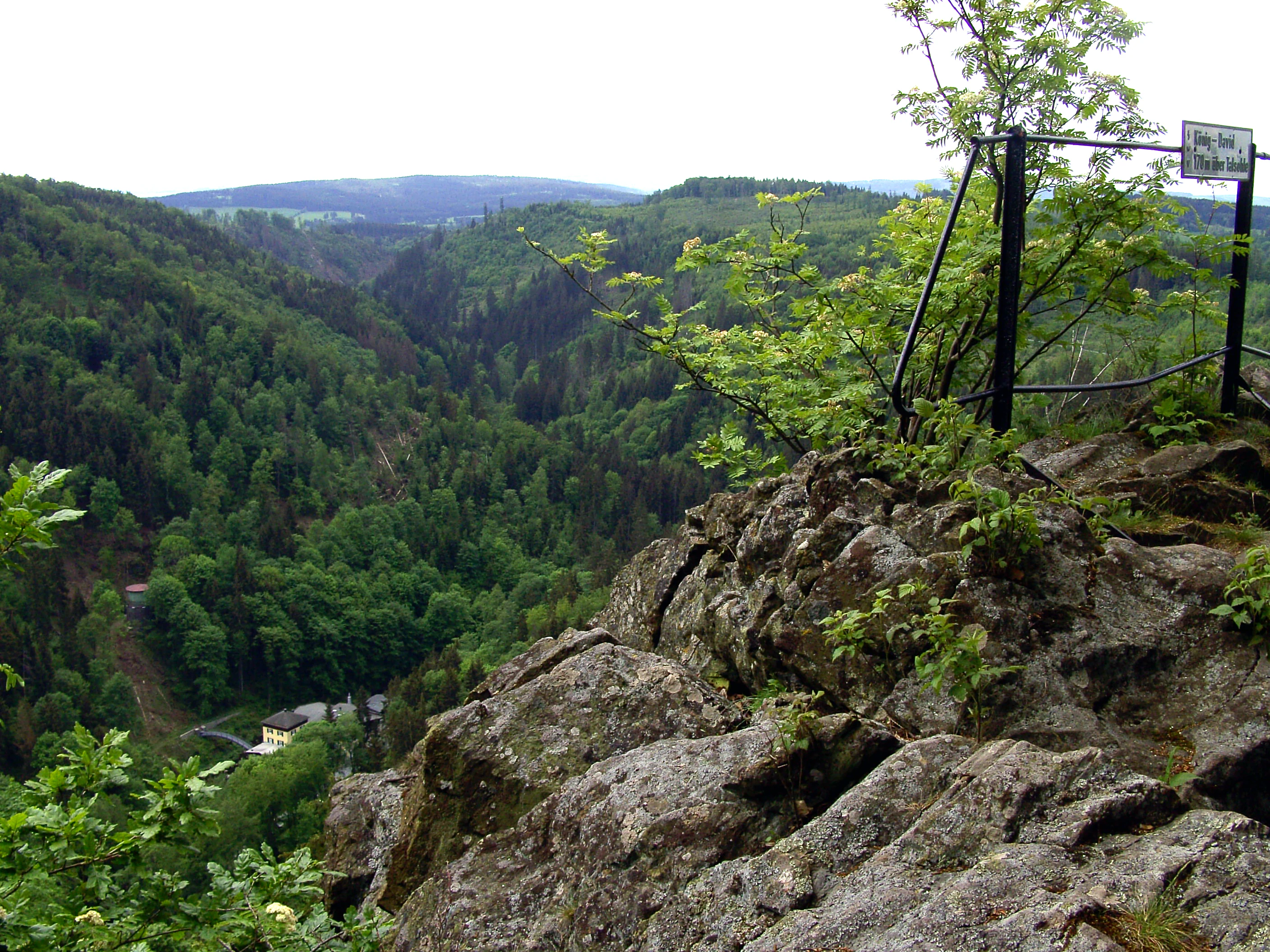
A high-angle view looking down into a forested valley from a rocky cliff, with a metal railing and a sign in the foreground.
View overlooking the Hoellental valley from the Koenig David viewpoint in Naturpark Frankenwald.

Naturpark Frankenwald history and protected-area timeline

Naturpark Frankenwald was officially established on 23 April 1973, becoming one of the early designated Naturparke in Bavaria and Germany. Its founding reflected the growing German movement of the late 1960s and early 1970s to formally recognize and protect characteristic regional landscapes, particularly those defined by their forest cover, agricultural heritage, and historical settlement patterns.

The park was built around the existing Frankenwald region, an upland area long associated with forestry, small-scale farming, and dispersed villages. By selecting this landscape as a Naturpark, regional authorities aimed to preserve the wooded character and cultural identity of the area while encouraging sustainable tourism, environmental education, and rural development.

In the decades after its designation, the park consolidated its role within Germany's Naturpark network, eventually connecting directly across the state border with the Thuringian Wald and Thüringer Schiefergebirge/Obere Saale nature parks. Together, these three parks form a continuous landscape reserve of approximately 4,000 square kilometers, one of the largest contiguous Naturpark areas in central Germany. In 2017, the Frankenwald was honored as Waldgebiet des Jahres (Forest Area of the Year) in Germany, further highlighting the park's significance for forest landscape conservation.

Naturpark Frankenwald landscape and geographic character

The Frankenwald is a gently mountainous, heavily wooded upland lying between roughly 400 and 800 meters in elevation, with rolling ridges, narrow valleys, and a network of small streams. The terrain is shaped by long geological processes typical of the central German uplands, producing a landscape of alternating forest stands, meadows, and modest agricultural clearings.

The region's river valleys, carved by small tributaries flowing generally southward and westward into the larger Main drainage system, create characteristic narrow gorges and broader basin landscapes. Among these, the Höllental is one of the most visually distinctive, a steep, forested valley that has become closely associated with the identity of the Frankenwald. The combination of forest, valley, agricultural land, and scattered villages gives the park a layered appearance in which natural and cultural elements are tightly interwoven.

The park's broad geographic position is also part of its landscape character. As a transitional area between the higher Thuringian Forest and the Fichtelgebirge, the Frankenwald reflects influences from neighboring uplands while retaining its own gentler relief and dense woodland cover.

Naturpark Frankenwald ecosystems, habitats, and plant life

The Naturpark Frankenwald protects one of the larger contiguous mixed forest landscapes of northern Bavaria. Forest dominates much of the park area, with coniferous and deciduous stands reflecting both the natural forest potential of the upland soils and the long history of managed forestry in the region. Spruce, fir, beech, and oak are among the typical species, shaped by centuries of use as both working forest and source of timber.

Beyond the forest, the park contains stream valleys, small open meadows, hedgerows, and traditional agricultural patches that contribute to habitat diversity. These structural variations support a wide range of forest interior species as well as edge and open-land species, creating an ecological mosaic rather than a single uniform forest block.

The park lies within the broader ecological context of the central German uplands, where the Frankenwald functions as a connective wooded landscape linking the Thuringian forests to the north with the Fichtelgebirge and other Franconian forest areas to the south and east. This position enhances its value for forest-dwelling species and landscape-scale ecological processes.

Naturpark Frankenwald wildlife and species highlights

The Frankenwald's extensive mixed forests and stream valleys support wildlife typical of central German uplands. The forest interior habitats host species such as red deer, roe deer, and wild boar, while smaller mammals including foxes, martens, and various rodents inhabit both deep forest and the edges between woodland and farmland.

Birdlife benefits from the mix of mature forest, young growth, watercourses, and open clearings. Woodpeckers, owls, and a variety of songbirds are characteristic of the area, along with species commonly associated with small streams and wet woodland edges. Bats find roosting and foraging habitat among old trees, barns, and the less disturbed forest stands.

The streams and rivers of the park support freshwater species including fish such as trout in suitable waters, while amphibians and invertebrates find habitat along the network of small valleys and associated wet areas. The park's value for wildlife is closely linked to the continuity and breadth of its forest cover rather than to any single charismatic species, making it an important area for overall forest biodiversity in the region.

Naturpark Frankenwald conservation status and protection priorities

Naturpark Frankenwald was established specifically to safeguard the regional character of the Frankenwald landscape, balancing forest protection, sustainable land use, and the maintenance of traditional rural settlement. Its designation as one of Germany's recognized Naturparke places it within a national framework of landscape-scale conservation areas that emphasize ecological function alongside cultural and economic viability.

A central element of the park's conservation role is the preservation of extensive, contiguous forest cover in a region where forest has historically shaped both ecology and economy. By supporting sustainable forestry, protecting habitat mosaics, and reducing pressures from fragmentation, the park contributes to maintaining forest biodiversity and ecosystem services such as water retention, carbon storage, and soil protection across the upland.

The park's transboundary connection with the Thuringian nature parks amplifies its conservation value. Together, the three parks form roughly 4,000 square kilometers of protected landscape across the state border, creating one of the larger continuous forest conservation landscapes in central Germany. Recognition of the Frankenwald as Waldgebiet des Jahres (Forest Area of the Year) in 2017 further underlined its significance as a forest landscape of national conservation interest.

Naturpark Frankenwald cultural meaning and human context

The Frankenwald has long been a working cultural landscape, shaped by centuries of forestry, small-scale agriculture, and dispersed settlement. Villages, small towns, and historic sites are integral to the park's identity, reflecting the region's traditions as a rural, forest-oriented part of Upper Franconia.

Within the park, cultural heritage sites such as the Festung Rosenberg in Kronach, the historic town of Lichtenberg, and the railway station at Steinwiesen offer connections to the region's architectural and industrial past. These sites coexist with active local communities whose traditional land uses are recognized within the Naturpark framework.

The park's identity is also shaped by its cross-border position: as part of a continuous Naturpark area with the Thuringian parks to the north, it reflects the historical, cultural, and ecological ties between northern Bavaria and the neighboring Thuringian landscapes, reinforcing a regional identity that spans modern administrative boundaries.

Top sights and standout views in Naturpark Frankenwald

Among the park's standout features are the densely forested ridges and narrow valleys of the Frankenwald itself, including the well-known Höllental, which captures the region's classic scenery of forest, rock, and stream.

The park also stands out for its scale and integration. As one of the larger Naturparke in Bavaria at roughly 1,023 square kilometers, and as the southern link in a chain of contiguous nature parks totaling around 4,000 square kilometers, Frankenwald represents a major continuous protected landscape in central Germany. Its combination of working cultural landscape, extensive forest, and accessible visitor infrastructure, including multiple Naturpark information points, makes it a practical example of the German Naturpark model in action.

Best time to visit Naturpark Frankenwald

The Frankenwald has a temperate upland climate, with cool winters, mild summers, and distinct seasonal changes in forest color and atmosphere. Late spring and early summer bring fresh green foliage and active birdlife in the valleys and forest edges, while autumn is often considered especially rewarding for visitors interested in the region's woodland character, when mixed forests display shifting colors and the crisp air accentuates views across the ridges.

Winter can offer a quieter, snow-dusted forest atmosphere in the higher parts of the park, though conditions vary with elevation. Summer provides the longest daylight hours and the most comfortable conditions for extended hiking and exploration of the park's information centers and villages. Because the park blends forest, valley, and settled areas, seasonal visits can offer noticeably different experiences without dramatic shifts in accessibility across the year.

Monthly climate preview

Long-term representative averages and monthly weather patterns across the protected landscape

Naturpark Frankenwald Climate Normals, Temperature and Precipitation Rhythms

Naturpark Frankenwald exhibits a measured annual temperature and precipitation rhythm derived from long-term coordinate sampling between 1991 and 2020. Examining the complete twelve-month climate profile reveals deeper baseline variations in temperature ranges and precipitation totals across the protected area.
Annual mean8 °C
-2 °C18 °C
Jan-2°
Feb-1°
Mar
Apr
May12°
Jun16°
Jul18°
Aug18°
Sep13°
Oct
Nov
Dec-1°
Warmest month
July

18 °C

Coolest month
January

-2.1 °C

Wettest month
July

2.7 mm/day

Driest month
April

1.4 mm/day

Park location guide

Geography guide, regional context, and park location map for Naturpark Frankenwald

Naturpark Frankenwald park geography, regions, and map view in Germany

Understand where Naturpark Frankenwald sits in Germany through a broader geographic reading of the surrounding landscape, nearby location context, and its mapped position within the national park landscape.

How Naturpark Frankenwald fits into Germany

Germany is a federal republic in Western and Central Europe with a population of over 83 million across sixteen constituent states. It is Europe's largest economy by nominal GDP and a major global exporter and importer. The capital is Berlin, and the country borders Denmark, Poland, Czech Republic, Austria, Switzerland, France, Luxembourg, Belgium, and the Netherlands.

Wider geography shaping Naturpark Frankenwald in Germany

Germany is located in Western and Central Europe, spanning 357,022 km². It borders Denmark to the north, Poland and the Czech Republic to the east, Austria and Switzerland to the south, and France, Luxembourg, Belgium, and the Netherlands to the west. The country has coastlines on the Baltic Sea and North Sea to the north, with the Alps located in the southern region.

Map view of Naturpark Frankenwald

Use this park location map to pinpoint Naturpark Frankenwald in Germany, understand its exact geographic position, and read its mapped placement within the surrounding landscape more clearly.

Pigeon | © OpenStreetMap contributors

Location context for Naturpark Frankenwald

Bavaria
Recorded earthquake history

Examine the Recorded Earthquake History for Naturpark Frankenwald

Access a structured, mapped collection of historical seismic events associated with the Naturpark Frankenwald landscape. MoriAtlas provides this filtered earthquake catalogue to help users understand the regional seismic distribution and historical activity surrounding this Bavarian protected area.

Naturpark Frankenwald Earthquake History

Catalogued events

56 events

Strongest magnitude

Magnitude 5.1

Most recent event

May 22, 2018

This history includes earthquakes recorded inside the park or within 50 km of its borders

Visualizing the forested ridges, river valleys, and protected terrain of Upper Franconia

Naturpark Frankenwald Photos and Landscape Scenery

Visual documentation captures the dense mixed forests, rolling uplands, and steep river valleys defining the protected terrain of Naturpark Frankenwald. Examining authentic regional imagery provides a clearer understanding of the varied topography, woodland habitats, and cultural landscape character preserved across the region.

A high-angle view looking down into a forested valley from a rocky cliff, with a metal railing and a sign in the foreground.

Park atlas

Compare connected upland nature reserves and regional transboundary terrain.

Parks Near Naturpark Frankenwald and Surrounding Protected Landscapes

Explore other protected areas near Naturpark Frankenwald to examine connected forested ridges and regional upland geography. Comparing adjacent parks reveals broader transitional landscape patterns across the central German uplands.
A soft watercolor painting of a winding river flowing through green rolling hills and meadows under a hazy, bright sky.
Protected landscapeBavaria
8.1 km away#1 closest

South

Naturpark Fränkische Schweiz, Frankenjura: An Atlas of Bavarian Karst and Forested Landscapes

Protected landscape geography within the northern Franconian Jura.

Naturpark Fränkische Schweiz, Frankenjura is a landmark protected area covering over 2,300 square kilometers across Bavaria. Its terrain is defined by a rhythmic sequence of limestone plateaux, winding river valleys, and dolomite formations, balanced by the quieter, pine-dominated reaches of the Veldensteiner Forst. This atlas entry details the park's geological complexity and its significant role in regional conservation.

Area
2,335.44 km²
Established
1968
Relief
Upland
Climate
Temperate
A horizontal watercolor illustration showing soft green hills, forest patches, and distant pale pink mountains.
Nature reserveThuringia
About 14 km away#2 closest

Northeast

Kobersfelsen Nature Reserve: Silicate Cliff Geography and Protected Valley Landscapes

Geographic context for the Thuringian Slate Mountains protected area.

Kobersfelsen features a significant silicate rock outcrop rising above the Saale valley. As part of a larger Habitats Directive site, this nature reserve integrates cliffside forest with rare botanical communities. Users can examine the specific site boundaries and understand its role within the wider ecological network of the Thuringian region.

Area
0.06 km²
Established
1989
IUCN
IV
Relief
Upland
Nature reserveThuringia
15 km away#3 closest

Northwest

Werra bis Treffurt mit Zuflüssen: Protected River and Floodplain Network in Thuringia

Mapping an extensive 191 kilometer Natura 2000 river corridor.

The Werra bis Treffurt mit Zuflüssen protected area serves as a vital ecological corridor in Thuringia. This site encompasses a complex mosaic of fast-flowing highland brooks, expansive floodplain meadows, inland salt sites, and rare dissolution lakes. Its geography bridges high-altitude source regions with lower river valleys, creating a distinctive landscape transect that supports essential freshwater habitats and rare aquatic species across the state.

Area
22.6 km²
Established
2008
IUCN
IV
Relief
Mixed relief
A horizontal watercolor painting showing soft, light-colored rolling hills and distant mountain ridgelines, with clusters of green trees in the foreground.
Nature reserveBavaria
About 15 km away#4 closest

Southwest

Naturwald Vierzehnheiligen Protected Area and Bavarian Forest Geography

Nature reserve featuring old-growth deciduous stands and limestone slope terrain

Naturwald Vierzehnheiligen comprises a vast, strictly protected forest in Upper Franconia, Germany. Spanning the foothills of the northern Franconian Jura, this reserve is defined by its structurally diverse canopy, moist ravine habitats, and limestone geological formations. It provides a essential study in non-intervention woodland management, serving as a critical refuge for broadleaved-forest species within the regional Bavarian landscape.

Area
5.413 km²
Established
2020
Relief
Upland
Climate
Temperate
A soft watercolor painting showing a pond landscape with rolling hills in the background, green trees in the midground, and tall grasses along the water edge.
Nature reserveSachsen
20 km away#5 closest

Northeast

Großer Weidenteich Nature Reserve: Mapping the Biodiversity of the Saxon Vogtland

A vital protected landscape shaped by traditional grazing management

Großer Weidenteich acts as a crucial refuge for diverse species, including nearly 700 butterfly varieties and numerous breeding bird populations. The reserve's landscape is characterized by a mix of wetlands, meadows, and shrubby margins that rely on continuous sheep grazing for structural maintenance. This area provides a clear perspective on how small-scale water bodies and varied vegetation patches contribute to the health of the broader Saxon regional ecosystem.

Area
3.349 km²
Established
1994
IUCN
IV
A soft watercolor painting of a rolling landscape with green hills, scattered trees, and pale, earthy foreground textures.
Nature reserveThuringia
About 20 km away#6 closest

North

Buchenberg bei Krölpa Nature Reserve: Mapped Geography and Protected Landscape Context

A restored limestone quarry habitat located in Thuringia, Germany.

Buchenberg bei Krölpa stands as a regionally significant nature reserve located east of Krölpa. Formerly a site of limestone extraction, the protected area now functions as a managed habitat, characterized by its broken, stepped terrain and slopes that host native orchid species and dry grassland vegetation within the broader Thuringian countryside.

Area
0.201 km²
Established
1996
IUCN
IV
Relief
Upland
A horizontal watercolor painting showing a soft, stylized landscape of rolling green hills, gentle slopes, and a calm body of water against a light pastel sky.
Nature reserveThuringia
20 km away#7 closest

North

Plothener Teiche Nature Reserve: Geographic Map and Protected Wetland Landscape Overview

Historic pond landscapes in the Saale-Orla-Kreis region of Thuringia

Plothener Teiche serves as a defining example of medieval-origin fishpond management in central Germany. This protected landscape combines open water basins, reed-lined margins, and woodland edges within the Thüringer Schiefergebirge and Obere Saale Nature Park. The area provides essential habitat for migratory bird populations and stands as a restored model of European wetland ecology.

Established
1967
IUCN
IV
Relief
Lowland
Climate
Temperate
Protected landscapeBavaria
26 km away#8 closest

Southeast

Naturpark Nördlicher Oberpfälzer Wald: Protected Landscape and Regional Geography Map

Forested upland terrain and volcanic geology in Bavaria

Explore the structured geography of Naturpark Nördlicher Oberpfälzer Wald, a massive protected region in Bavaria. This detailed profile highlights the park's characteristic ridge and valley terrain, volcanic basalt landmarks, and its role as a vital ecological belt along the international border.

Area
1,380 km²
Water
Minor water

Common questions about visiting, size, designation, and location context for Naturpark Frankenwald

Naturpark Frankenwald FAQs for park facts, access, geography, and protected area context

Find quick answers about Naturpark Frankenwald, including protected-area facts, park geography, trail and visitor context, and how the park fits into its surrounding country and regional landscape.
MoriAtlas Explorer

Continue Your Protected Areas Search Across the Global Atlas

Deepen your exploration by continuing the structured search for national parks and protected areas worldwide. Utilize the comprehensive filtering capabilities to compare different conservation landscapes and refine your understanding of global park geography. Discover more about the distribution and characteristics of protected natural areas.

Global natural geography