
Mori Atlas logo
Nature reserveNaturschutzgebiet Grotenberg bei Welleringhausen

A vital ecological refuge featuring diabase slopes and traditional conservation grazing in northern Hesse.

Naturschutzgebiet Grotenberg bei Welleringhausen: Protected Silicate Grassland and Upland Geography

Naturschutzgebiet Grotenberg bei Welleringhausen occupies the southern slopes of the Grotenberg hill within the Waldeck-Frankenberg district. This nature reserve protects a rare patch of acid silicate dry grassland, providing a unique look at how traditional sheep grazing maintains specialized upland habitats in the eastern Sauerland mountains. The site showcases a distinct mosaic of exposed rock, nutrient-poor soil, and diverse plant communities shaped by the underlying diabase geology.

nature reservesilicite dry grasslanddiabase slopeupland landscapesheep grazinglichen community
A flat-style digital illustration showing a valley with steep rock cliffs, pine trees, a winding river, and a waterfall under a setting sun.

Naturschutzgebiet Grotenberg bei Welleringhausen

Nature reserve

Park overview

Structured park overview, official facts, and landscape profile for Naturschutzgebiet Grotenberg bei Welleringhausen

Naturschutzgebiet Grotenberg bei Welleringhausen park facts, protected area profile, and essential visitor context

Review the core facts for Naturschutzgebiet Grotenberg bei Welleringhausen, including designation, size, terrain, visitor scale, habitats, and operating context in one park-focused overview.

About Naturschutzgebiet Grotenberg bei Welleringhausen

Naturschutzgebiet Grotenberg bei Welleringhausen is a small but ecologically focused nature reserve in the Upland region of northern Hesse, near the border with North Rhine-Westphalia. The protected site sits on the southern slope of the Grotenberg hill, rising just north of the village of Welleringhausen within the municipality of Willingen (Upland). Despite covering less than twenty hectares, the reserve concentrates on a habitat type that is increasingly rare along the eastern margin of the Sauerland mountains: acid silicate dry grassland developed on nutrient-poor diabase rock.

The reserve was formally designated in 1992 to safeguard the botanical and zoological values of the slope. The dry grassland here is characteristic of the eastern Sauerland upland fringe, where shallow, acidic soils over volcanic-derived diabase create conditions that exclude most common pasture plants and instead favor a specialized assemblage of stress-adapted grasses, herbs, mosses, and lichens. The openness of the slope, its southerly exposure, and its traditional use as grazing land have all helped to maintain this distinctive vegetation pattern.

The Grotenberg lies within the broader Naturpark Diemelsee, a regional landscape that links several small nature reserves, cultural landscapes, and recreational areas of the Upland. By protecting the slope above Welleringhausen, the reserve helps to maintain the visual and ecological transition between the village and the surrounding forested upland. It also contributes to the broader network of protected sites in the Landkreis Waldeck-Frankenberg, supporting connectivity for grassland-dependent species across the region.

Because the reserve is small and concentrated, it functions as a focused conservation site rather than a broad recreational area. Its purpose is to keep a representative sample of an uncommon habitat type intact, and to demonstrate how low-intensity grazing can sustain ecological diversity in upland landscapes shaped historically by human land use.

Quick facts and research context for Naturschutzgebiet Grotenberg bei Welleringhausen

Naturschutzgebiet Grotenberg bei Welleringhausen is a nature reserve in Hesse, Germany, designated in 1992 for its botanical and zoological significance. It lies on the southern slope of the Grotenberg hill, just north of Welleringhausen in the municipality of Willingen (Upland), and falls inside the Naturpark Diemelsee. The protected area covers approximately 19.77 hectares, of which around ten hectares support acid silicate dry grassland, an exceptionally rare habitat type along the eastern edge of the Sauerland uplands.

The reserve is classified as an IUCN Category IV Habitat and Species Management Area and is registered in the World Database on Protected Areas under the ID 163386. It sits in the Landkreis Waldeck-Frankenberg and is one of several small nature reserves that together form the protected-area network of the Willingen area and the surrounding Upland region.

Protection and recognition

Documented conservation parameters and official registry recognition records for this protected landscape.

Naturschutzgebiet Grotenberg bei Welleringhausen Protection Status and Designated Area Record

Examine the verified protection status and administrative designation records for Naturschutzgebiet Grotenberg bei Welleringhausen within the global park database. Official registry listings provide clear reference data regarding conservation parameters and territorial management history.

Protection details

WDPA ID
163386
Park context

Deeper park guide and search-rich context for Naturschutzgebiet Grotenberg bei Welleringhausen

Naturschutzgebiet Grotenberg bei Welleringhausen history, landscape, wildlife, and travel context

Explore Naturschutzgebiet Grotenberg bei Welleringhausen through its history, landscape character, ecosystems, wildlife, conservation priorities, cultural context, and seasonal travel timing in a structured park guide built for atlas discovery and search intent.

Why Naturschutzgebiet Grotenberg bei Welleringhausen stands out

The reserve is best known for its ten-hectare stand of acid silicate dry grassland, a habitat that is otherwise scarce in the eastern foothills of the Sauerland mountains. These nutrient-poor grasslands on diabase substrate support a surprisingly rich community of specialized plants, birds, insects, and lichens for such a small site. It also stands out as an example of successful restoration through grazing, where former spruce plantations on the upper slopes have been removed and replaced by extensive grazing with Heidschnucken sheep to bring back the open grassland character that originally shaped the landscape.
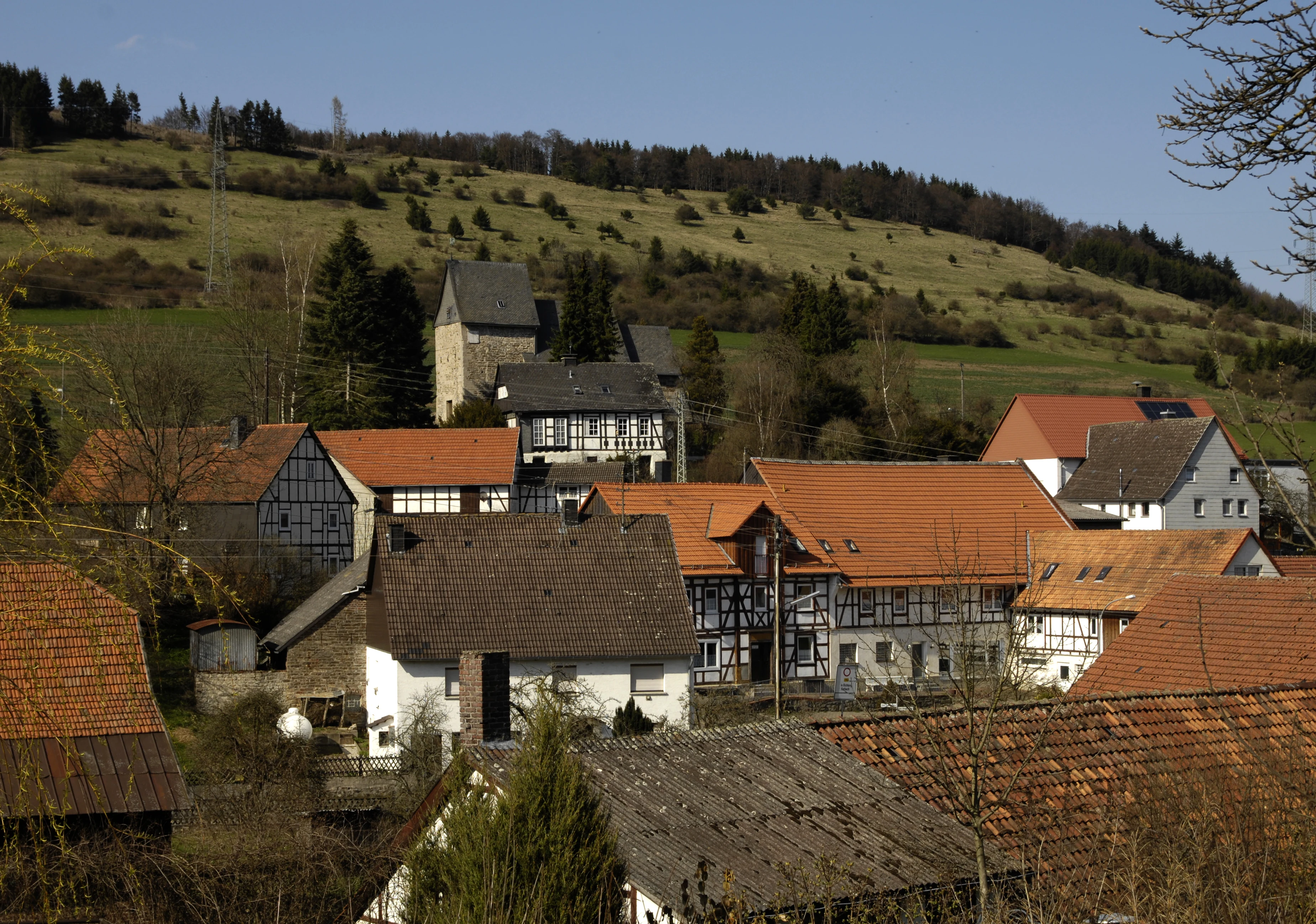
A cluster of traditional timber-framed houses with red tiled roofs in a village setting, with a large grassy hillside rising behind them.
A view of the village of Welleringhausen with the Grotenberg ridge in the background.

Naturschutzgebiet Grotenberg bei Welleringhausen history and protected-area timeline

The dry grassland of the Grotenberg slope is itself a product of long-standing agricultural use, having been shaped by extensive sheep grazing that suppressed woody plants and maintained open, species-rich sward on the shallow soils. This traditional land use created the conditions that later justified formal protection.

In the late 1950s, the upper slopes of the Grotenberg were planted with spruce, a common afforestation practice of the period that aimed to use marginal land for timber production. Over subsequent decades, this conifer planting encroached onto the open grassland and threatened to shade out the specialized species that depended on it.

The area was finally designated as a nature reserve in 1992 under the identifier 1635046, recognized for its botanical and zoological significance. Following designation, active management began to reverse the earlier afforestation: spruce trees were progressively removed and extensive grazing with Heidschnucken sheep was reintroduced to restore the open, species-rich grassland character of the slope. These measures reflect the modern conservation approach in German Naturschutzgebiete, where active management is used to maintain habitats that depend on continued low-intensity land use.

Naturschutzgebiet Grotenberg bei Welleringhausen landscape and geographic character

The landscape of the reserve is defined by a single prominent feature: the southern slope of the Grotenberg hill. This south-facing slope receives more sunlight and warmth than the surrounding terrain, creating drier, warmer microclimatic conditions that favor grassland over forest.

The underlying geology is diabase, a fine-grained volcanic rock that weathers into shallow, nutrient-poor, acidic soils. These substrate conditions are central to the landscape's character, because they prevent competitive grasses and shrubs from dominating and instead allow stress-adapted, slow-growing plant communities to flourish. The result is a distinctive open, low-growing sward with patches of exposed rock and thin soil.

The surrounding region belongs to the Upland, the eastern extension of the Sauerland mountains, where rounded ridges, mixed forests, and small upland villages form a characteristic mosaic. Within this mosaic, the Grotenberg slope stands out as a bright, grass-covered opening above the darker forest belt, visible from Welleringhausen and from higher vantage points in the surrounding hills. The reserve is small enough to be walked across in a short visit, but the topography gives it a strong visual presence in the local landscape.

Naturschutzgebiet Grotenberg bei Welleringhausen ecosystems, habitats, and plant life

Ecologically, the reserve is dominated by acid silicate dry grassland, a habitat type that has become scarce in the eastern foothills of the Sauerland. Roughly ten hectares of the protected area support this vegetation, which is dominated by small, stress-tolerant grasses and herbs adapted to acidic, nutrient-poor, drought-prone conditions on diabase rock.

Surveys of the reserve have recorded 163 vascular plant species across the site as a whole. On the exposed rocks within the protected area, lichens are a prominent component of the biological community. Reindeer lichens and shield lichens are particularly well represented and contribute to the characteristic appearance of the open rock surfaces.

The combination of warm, dry slopes, shallow soils, and traditional grazing has produced a habitat mosaic that supports both plant specialists and a diverse insect fauna. The reserve's ecological significance lies less in its size than in the concentration of uncommon habitat types within a single small site, making it a valuable reference area for the conservation of silicate grassland communities in the region.

Naturschutzgebiet Grotenberg bei Welleringhausen wildlife and species highlights

The wildlife of the Grotenberg reserve reflects its open, dry, sun-exposed character. Breeding bird surveys have identified important populations of species typical of open and semi-open upland habitats. The recorded species include the common whitethroat, the great grey shrike, and the red-backed shrike, as well as twelve territories of tree pipits and six territories of meadow pipits, an unusually high density for such a small site.

The insect fauna has been surveyed in some detail. Eleven butterfly species have been recorded in the reserve, along with sixteen beetle species and six grasshopper species. Among the grasshoppers, the wart-biter, a species of conservation interest in Germany, has been documented.

The combination of breeding birds of dry grassland and shrub-edge habitats, together with a notable diversity of butterflies, beetles, and grasshoppers, indicates that the reserve functions as an important refuge for warm-adapted invertebrate and bird communities that have become rare in more intensively used landscapes of the region.

Naturschutzgebiet Grotenberg bei Welleringhausen conservation status and protection priorities

The reserve was designated in 1992 specifically to protect the botanical and zoological values of the slope, and its formal designation text emphasizes the rarity, distinctive character, and beauty of the area. This language reflects the standard German approach to Naturschutzgebiete, where habitats and species of regional or national significance receive legal protection against damaging land use changes.

Beyond passive protection, the reserve is actively managed. Spruce plantations that were established in the late 1950s on the upper slopes have been progressively removed, and extensive grazing with Heidschnucken sheep has been reintroduced to maintain the open grassland character. This combination of habitat restoration and traditional grazing management is essential because the grassland habitat itself is a product of human land use and would otherwise revert to forest.

At a regional level, the Grotenberg reserve is one of several small protected sites within the Naturpark Diemelsee, and it contributes to the broader network of Naturschutzgebiete in the Landkreis Waldeck-Frankenberg. The site is registered internationally in the World Database on Protected Areas under the ID 163386 and is classified as an IUCN Category IV Habitat and Species Management Area, recognizing its role in targeted conservation of a specific habitat type.

Naturschutzgebiet Grotenberg bei Welleringhausen cultural meaning and human context

The landscape that the reserve protects is closely tied to the cultural history of the Upland region. For generations, the slopes around villages such as Welleringhausen were used for extensive sheep grazing, a practice that shaped both the vegetation and the visual character of the area. The dry grassland of the Grotenberg is itself a legacy of this traditional land use.

The late twentieth-century shift toward spruce afforestation on marginal land marked a break with that tradition, and the reserve's modern management, including the deliberate use of Heidschnucken grazing, represents a conscious effort to reconnect conservation with the cultural landscape heritage of the region. In this sense, the reserve is as much a product of local agricultural history as it is a site of natural heritage.

Top sights and standout views in Naturschutzgebiet Grotenberg bei Welleringhausen

The reserve's principal highlight is its compact stand of acid silicate dry grassland, a habitat that is otherwise vanishingly rare at the eastern edge of the Sauerland mountains and that hosts 163 recorded vascular plant species.

Its breeding bird assemblage, including great grey shrike, red-backed shrike, common whitethroat, and a notable density of tree pipits and meadow pipits, together with the presence of the wart-biter grasshopper and a rich lichen flora on exposed rocks, distinguishes the site as a disproportionately species-rich refuge for its size.

The active restoration story, from spruce invasion back to open sheep-grazed grassland, gives the reserve additional value as a demonstration of how traditional land use can be revived to sustain specialized upland habitats.

Best time to visit Naturschutzgebiet Grotenberg bei Welleringhausen

Because the reserve's ecological interest rests on its open grassland character, late spring and summer are the most rewarding times for visitors interested in seeing the grassland in active growth and in hearing breeding birds. Warm, sunny days typically bring out the richest insect activity and make the lichen communities on the rocks easiest to observe.

In autumn, the grasses and herbs take on drier tones, and the contrast between the bright open slope and the surrounding darker forests becomes more pronounced, while in winter the reserve's open structure is at its most visible from the village below. Visitors should always remain on existing paths, as the small size of the reserve means that trampling can have a noticeable effect on its fragile vegetation and lichen cover.

Monthly climate preview

Long-term temperature ranges and monthly precipitation records at a representative coordinate

Climate Normals and Annual Weather Patterns for Naturschutzgebiet Grotenberg bei Welleringhausen

Temperature and precipitation normals for Naturschutzgebiet Grotenberg bei Welleringhausen reveal a distinct annual rhythm spanning sub-zero winter minimums and warm summer peaks. Examining the complete twelve-month climate record provides deeper insight into long-term meteorological trends across this protected area.
Annual mean9 °C
0 °C18 °C
Jan
Feb
Mar
Apr
May12°
Jun15°
Jul18°
Aug18°
Sep14°
Oct
Nov
Dec
Warmest month
July

18 °C

Coolest month
January

-0.2 °C

Wettest month
July

2.6 mm/day

Driest month
April

1.7 mm/day

Park location guide

Geography guide, regional context, and park location map for Naturschutzgebiet Grotenberg bei Welleringhausen

Naturschutzgebiet Grotenberg bei Welleringhausen park geography, regions, and map view in Germany

Understand where Naturschutzgebiet Grotenberg bei Welleringhausen sits in Germany through a broader geographic reading of the surrounding landscape, nearby location context, and its mapped position within the national park landscape.

How Naturschutzgebiet Grotenberg bei Welleringhausen fits into Germany

Germany is a federal republic in Western and Central Europe with a population of over 83 million across sixteen constituent states. It is Europe's largest economy by nominal GDP and a major global exporter and importer. The capital is Berlin, and the country borders Denmark, Poland, Czech Republic, Austria, Switzerland, France, Luxembourg, Belgium, and the Netherlands.

Wider geography shaping Naturschutzgebiet Grotenberg bei Welleringhausen in Germany

Germany is located in Western and Central Europe, spanning 357,022 km². It borders Denmark to the north, Poland and the Czech Republic to the east, Austria and Switzerland to the south, and France, Luxembourg, Belgium, and the Netherlands to the west. The country has coastlines on the Baltic Sea and North Sea to the north, with the Alps located in the southern region.

Map view of Naturschutzgebiet Grotenberg bei Welleringhausen

Use this park location map to pinpoint Naturschutzgebiet Grotenberg bei Welleringhausen in Germany, understand its exact geographic position, and read its mapped placement within the surrounding landscape more clearly.

Pigeon | © OpenStreetMap contributors

Location context for Naturschutzgebiet Grotenberg bei Welleringhausen

Waldeck-Frankenberg

Visual exploration of acid silicate dry grasslands and upland habitats

Naturschutzgebiet Grotenberg bei Welleringhausen Photos, Scenery, and Landscapes

Photographic records capture the open southern slopes and specialized vegetation characteristic of Naturschutzgebiet Grotenberg bei Welleringhausen. Visual documentation reveals the protected diabase terrain and rare upland habitats maintained through conservation grazing.

A cluster of traditional timber-framed houses with red tiled roofs in a village setting, with a large grassy hillside rising behind them.

Park atlas

Compare adjacent upland reserves and connected conservation landscapes in the surrounding region.

Parks Near Naturschutzgebiet Grotenberg bei Welleringhausen and Regional Protected Areas

Visitors exploring Naturschutzgebiet Grotenberg bei Welleringhausen can continue comparing adjacent upland reserves and protected landscapes across the surrounding hills. Broadening the geographic scope reveals how similar habitats and regional terrain link conservation sites throughout the district.
Nature reserveHochsauerlandkreis
About 2.9 km away#1 closest

Southwest

Naturschutzgebiet Osterntal: Protected Valley Mosaic and Regional Geography

Explore nature reserve boundaries and ecological terrain in Hochsauerlandkreis.

Naturschutzgebiet Osterntal protects a distinct valley mosaic in the eastern Sauerland, featuring rare wet grasslands and nutrient-poor meadows. This nature reserve provides essential habitat connectivity within the broader European Bird Protection Area, showcasing the region's managed pastoral landscape and varied topography.

Area
0.064 km²
Established
2003
Relief
Upland
Climate
Temperate
Nature reserveHesse
About 4.4 km away#2 closest

West

Naturschutzgebiet Osterkopf bei Usseln: Protected Highland Heath and Upland Landscape

Hesse nature reserve with Atlantic-Boreal botanical features

Located in the Upland highlands of northern Hesse, this protected area features rare summit heath and species-rich mountain meadows. The reserve represents a functional link in the regional network of highland ecosystems, preserving specialized habitats characterized by mat-grass swards and an unusual northern vegetation profile.

Area
0.357 km²
Established
1982
IUCN
IV
Relief
Mountain
A soft watercolor painting depicting a landscape of rolling green hills, gentle slopes, and distant mountains against a plain background.
Nature reserveHessen
About 4.8 km away#3 closest

West

Naturschutzgebiet Kahle Pön bei Usseln: Protected Highland Heath and Upland Landscapes

A rare botanical nature reserve within the Hessian Upland landscape

Naturschutzgebiet Kahle Pön bei Usseln protects an open heath plateau above the Usseln valley, providing essential habitat for heath-breeding birds and rare butterflies. This nature reserve serves as an vital component of the transboundary highland heath network, demonstrating unique conservation efforts through sheep grazing and sod removal on former beech woodland soils in Waldeck-Frankenberg.

Area
0.35 km²
Established
1987
IUCN
IV
Nature reserveHochsauerlandkreis
About 6.1 km away#4 closest

Southwest

Naturschutzgebiet Almecke: Geographic Atlas and Protected Landscape Overview

A preserved hedgerow mosaic in the Hochsauerlandkreis region.

Naturschutzgebiet Almecke is a significant nature reserve characterized by its formal inclusion in the European bird protection area network. The site offers a concentrated look at traditional cultural landscapes, specifically the interaction between steep valley topography, contour-following hedgerows, and dry upland pastures. This protected area serves as an essential case study in localized conservation geography and habitat structure within the wider Sauerland region.

Area
0.058 km²
Established
2003
Relief
Upland
Scope
Terrestrial
Nature reserveWaldeck-Frankenberg
About 8.3 km away#5 closest

West

Naturschutzgebiet Jägers Weinberg: Geographic Profile of a Protected Upland Wetland

A mapped nature reserve in the Waldeck-Frankenberg district of northern Hesse

Naturschutzgebiet Jägers Weinberg is a protected wetland landscape in northern Hesse, Germany. This area preserves a rare combination of raised bog and birch swamp forest, functioning as a vital botanical refuge in the Waldeck-Frankenberg district. Its mapped boundaries highlight a specialized ecological site that offers clear insights into the micro-topography and natural history of the local Upland terrain.

Area
0.254 km²
Established
1979
IUCN
IV
Relief
Upland
A watercolor-style digital illustration of a gentle, rolling green landscape with a winding path and distant hills on a white background.
Nature reserveWaldeck-Frankenberg
About 8.3 km away#6 closest

West

Naturschutzgebiet Grebensteine bei Willingen: Protected Forest and Rock Outcrop Atlas

Ecological mapping of the Itter valley gorge forest in Waldeck-Frankenberg

This nature reserve protects a rare, near-primary gorge forest (Schluchtwald) in northern Hesse. Its steep slopes are characterized by isolated rock outcrops, boulder-rich substrates, and springs that foster high botanical diversity. The site serves as a critical example of upland forest conservation within the larger protected landscape of the Rothaargebirge foothills and the Diemelsee Nature Park.

Area
0.157 km²
Established
1985
IUCN
IV
Relief
Mountain
A horizontal watercolor painting depicting a soft, pastel-colored landscape with rolling hills in the background, a line of trees in the midground, and a small winding stream or boggy area in the foreground.
Nature reserveHessen
About 8.7 km away#7 closest

West

Naturschutzgebiet Alter Hagen bei Willingen: Protected Nature Reserve and Wetland Atlas

Landscape and geographic overview in the Hessen region

Naturschutzgebiet Alter Hagen bei Willingen covers a significant floodplain system in the Hessen uplands. This nature reserve serves as a critical habitat for diverse butterfly communities and relict woodland flora, centered on the headwaters of the River Itter. Its mix of swamps, bogs, and beech-dominated forest makes it a key site for understanding the geography of protected mire ecosystems in Central Germany.

Area
1.436 km²
Established
1989
IUCN
IV
Relief
Upland
Nature reserveNorth Rhine-Westphalia
About 9.6 km away#8 closest

Southwest

Naturschutzgebiet Oberes Dittelsbachtal - Klokenbruch: Regional Protected Area Map

Sauerland brook valley and meadow landscape

This nature reserve protects 14 hectares of the upper Dittelsbach stream and surrounding damp grasslands. The landscape is defined by its compact valley form, spring-fed mires, and traditional grazing patches, serving as an important link for bird protection in the Medebacher Bucht region of North Rhine-Westphalia.

Area
0.139 km²
Established
2003
Scope
Terrestrial
Water
Major water bodies

Common questions about visiting, size, designation, and location context for Naturschutzgebiet Grotenberg bei Welleringhausen

Naturschutzgebiet Grotenberg bei Welleringhausen FAQs for park facts, access, geography, and protected area context

Find quick answers about Naturschutzgebiet Grotenberg bei Welleringhausen, including protected-area facts, park geography, trail and visitor context, and how the park fits into its surrounding country and regional landscape.
MoriAtlas Explorer

Continue Your Protected Areas Search Across the Global Atlas

Deepen your exploration by continuing the structured search for national parks and protected areas worldwide. Utilize the comprehensive filtering capabilities to compare different conservation landscapes and refine your understanding of global park geography. Discover more about the distribution and characteristics of protected natural areas.

Global natural geography