
Mori Atlas logo
Nature reserveNaturschutzgebiet Oberes Elsetal

Understanding the mapped habitat mosaic of spring seepage zones, wet meadows, and riparian woodland.

Naturschutzgebiet Oberes Elsetal: A Representative Protected Brook Valley Landscape in North Rhine-Westphalia

Naturschutzgebiet Oberes Elsetal represents a refined example of a farmed Mittelgebirge brook valley located within the rolling terrain of the Südsauerländer Bergland. This protected area features a dense, structured mosaic of habitats including spring seepage zones, wet grasslands, tall herb fringes, and continuous alder gallery woodland along the upper Else stream. The site serves as a vital geographic link in the local landscape, preserving rare ecological conditions within a small, highly defined surface area in North Rhine-Westphalia.

brook valleystream headwaterswet grasslandmarshy meadowspring seepagetall herb fringe
A stylized graphic illustration of a mountainous landscape featuring a waterfall cascading between high cliffs, framed by evergreen trees in the foreground.

Naturschutzgebiet Oberes Elsetal

Nature reserve

Park overview

Structured park overview, official facts, and landscape profile for Naturschutzgebiet Oberes Elsetal

Naturschutzgebiet Oberes Elsetal park facts, protected area profile, and essential visitor context

Review the core facts for Naturschutzgebiet Oberes Elsetal, including designation, size, terrain, visitor scale, habitats, and operating context in one park-focused overview.

About Naturschutzgebiet Oberes Elsetal

Naturschutzgebiet Oberes Elsetal is a small but ecologically coherent nature reserve in the Südsauerländer Bergland, the southern Sauerland uplands of western Germany. It follows the headwaters of the Else stream through a shallow, agriculturally shaped valley south of the hamlet of Else, near the township of Herscheid. Although the protected surface is modest, the site concentrates a remarkable variety of brook, meadow, marsh, and woodland habitats into a narrow ribbon along the watercourse.

The valley begins in a shallow depression where the Else emerges from a grassy, seasonally trampled source area used as cattle pasture. From there the brook runs through about one kilometer of protected land. Its margins shift repeatedly: in some places they are open wet meadows grazed by livestock, in others ungrazed tall herb fringes dominated by meadowsweet, and elsewhere narrow strips of black alder forming a loose gallery forest. Lower in the valley, a particularly well-developed stand of pond horsetail and branched bur-reed reedbed marks a widening of the floodplain.

Beyond the immediate brook corridor, the reserve encompasses adjoining wet grassland, marshy fallow land, and, on the drier upper slopes, a small aging orchard as well as a remnant oak-hornbeam woodland fragment. This juxtaposition of wet valley floor and warmer, drier slope woodland gives the small reserve an unusually layered vegetation profile.

Although the site has no dramatic landmarks, its value lies precisely in this fine-grained mosaic. The North Rhine-Westphalia state office for nature, environment, and consumer protection (LANUV) describes the area as a locally important habitat complex with high structural diversity, and emphasizes the importance of maintaining extensive grassland use and protecting the spring zones from trampling by livestock.

Quick facts and research context for Naturschutzgebiet Oberes Elsetal

Naturschutzgebiet Oberes Elsetal covers about 5.3 hectares in Herscheid, a municipality in the Märkischer Kreis district of North Rhine-Westphalia. The reserve lies south and southeast of the small settlement of Else and borders the Plettenberg-Hüinghausen airfield to the east.

It was designated as a nature reserve in 1998 through Landscape Plan No. 5 Herscheid issued by the Märkischer Kreis. The site is officially catalogued under the identifier MK-067 in the North Rhine-Westphalia nature protection information system.

The reserve protects the upper reaches of the Else, a tributary of the Lenne, and a roughly one-kilometer stretch of the brook together with adjacent wet meadows, tall herb fringes, marshy fallow land, alder gallery woodland, and a small remnant of oak-hornbeam forest on the slope.

Protection and recognition

Documented terrestrial protection scope and conservation status data

Naturschutzgebiet Oberes Elsetal Protection Status and Recognition

Naturschutzgebiet Oberes Elsetal holds a defined terrestrial protection scope within its regional landscape boundary. Structured facts outline the recorded designation history and official recognition details available for the protected area.

Protection details

Protection scope
Terrestrial
Park context

Deeper park guide and search-rich context for Naturschutzgebiet Oberes Elsetal

Naturschutzgebiet Oberes Elsetal history, landscape, wildlife, and travel context

Explore Naturschutzgebiet Oberes Elsetal through its history, landscape character, ecosystems, wildlife, conservation priorities, cultural context, and seasonal travel timing in a structured park guide built for atlas discovery and search intent.

Why Naturschutzgebiet Oberes Elsetal stands out

The reserve is best known as a textbook example of a farmed Mittelgebirge brook valley, where a near-natural spring brook, wet meadows, tall herb fringes, and alder riparian woodland remain tightly interlinked. Its defining quality is the tight structural mosaic of seepage areas, moist grasslands, and continuous shoreline woodland along a very short stretch of the Else stream. It also stands out as a refuge for moisture-loving plant communities such as marsh marigold meadows, meadowsweet tall herb fringes, and pond horsetail stands, set within an otherwise agricultural low mountain range landscape.
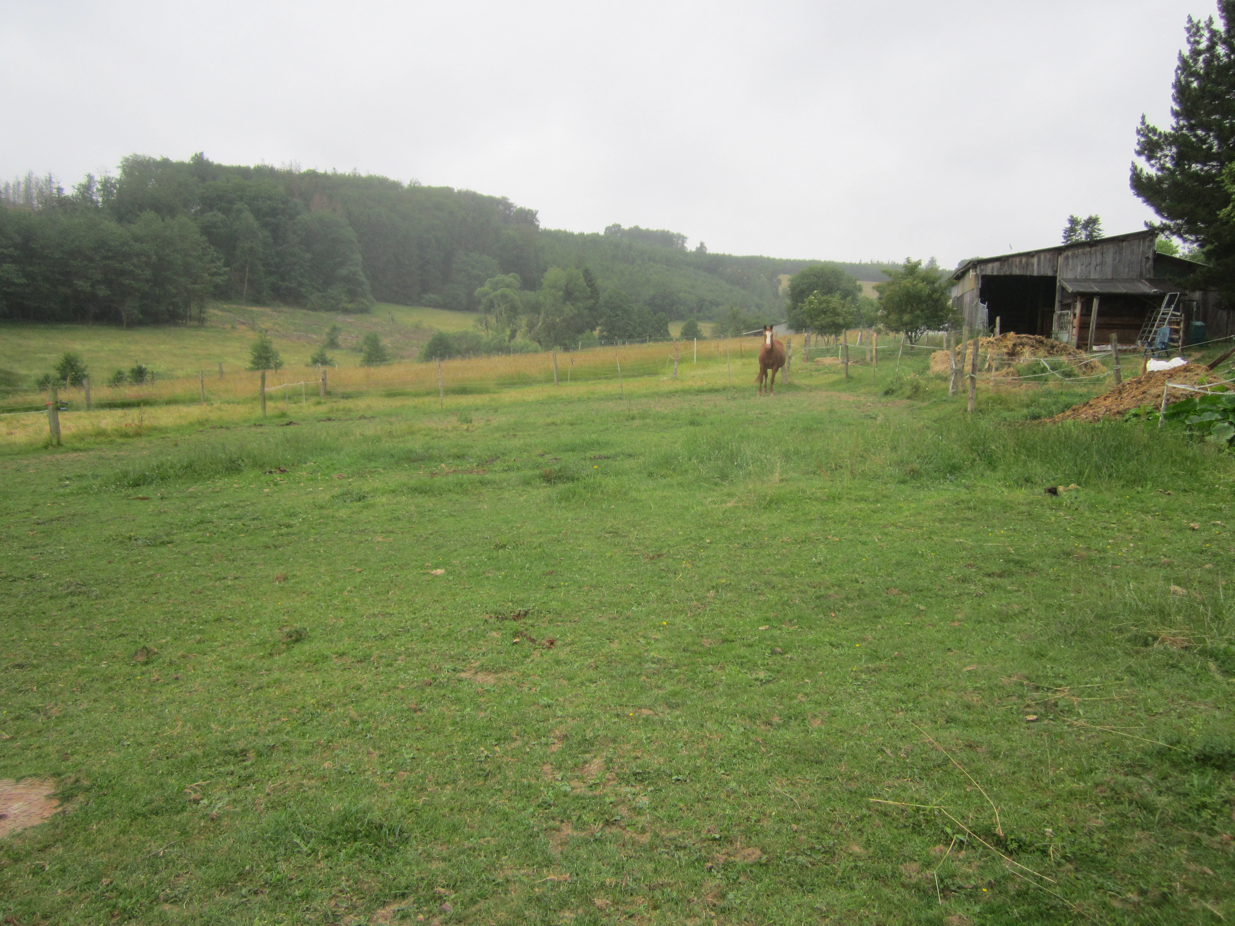
A green pasture with a horse standing in the middle distance; a small rustic wooden barn is on the right, with a forested hillside in the background under a cloudy sky.
A view of the open pastureland and meadow in the Oberes Elsetal nature reserve.

Naturschutzgebiet Oberes Elsetal history and protected-area timeline

The reserve was formally designated in 1998 under Landscape Plan No. 5 Herscheid, drawn up by the Märkischer Kreis, the administrative district in which Herscheid lies. This landscape plan, published in Lüdenscheid in the same year, established the legal framework that set aside the upper Else valley as a protected area.

Long before protection, the valley was shaped by traditional rural land use: grazing cattle on the water meadows, haymaking on the drier grassland, and small-scale orchard management on the slopes. The nature reserve designation was intended to preserve the surviving cultural landscape features such as meadow strips, fallow wet ground, and orchard remnants, while curbing the intensification of grassland use that had begun to threaten seepage habitats elsewhere in the region.

The site is catalogued in official state records as MK-067 and has since been included in broader inventories of protected areas in the Märkischer Kreis, including the published overview of nature reserves in the district by Michael Bußmann.

Naturschutzgebiet Oberes Elsetal landscape and geographic character

The protected area occupies a shallow brook valley set within the rolling uplands of the Südsauerländer Bergland. The terrain is gently sloping rather than dramatic, defined by the narrow floor of the upper Else valley and the rising valley flanks above it. The valley opens westward into a broader agricultural landscape and, in its eastern part, curves toward a slope edge where the brook locally cuts small stone banks into the hillside.

The valley floor is a mosaic of moist and wet grassland broken by marshy depressions and slow-moving spring seepage zones. Where the slope rises to the south, the land becomes drier and supports orchard remnants and woodland. To the east, the boundary of the reserve meets the terrain associated with the Plettenberg-Hüinghausen airfield, giving the protected strip a clear eastern edge.

Although the surface is only about 5.3 hectares, the landscape reads as layered: wet valley bottom, tall herb fringe, riparian alder gallery, slope woodland, and, beyond the reserve, surrounding farmland and meadows. This layering in such a small area is one of the defining topographical characteristics of the site.
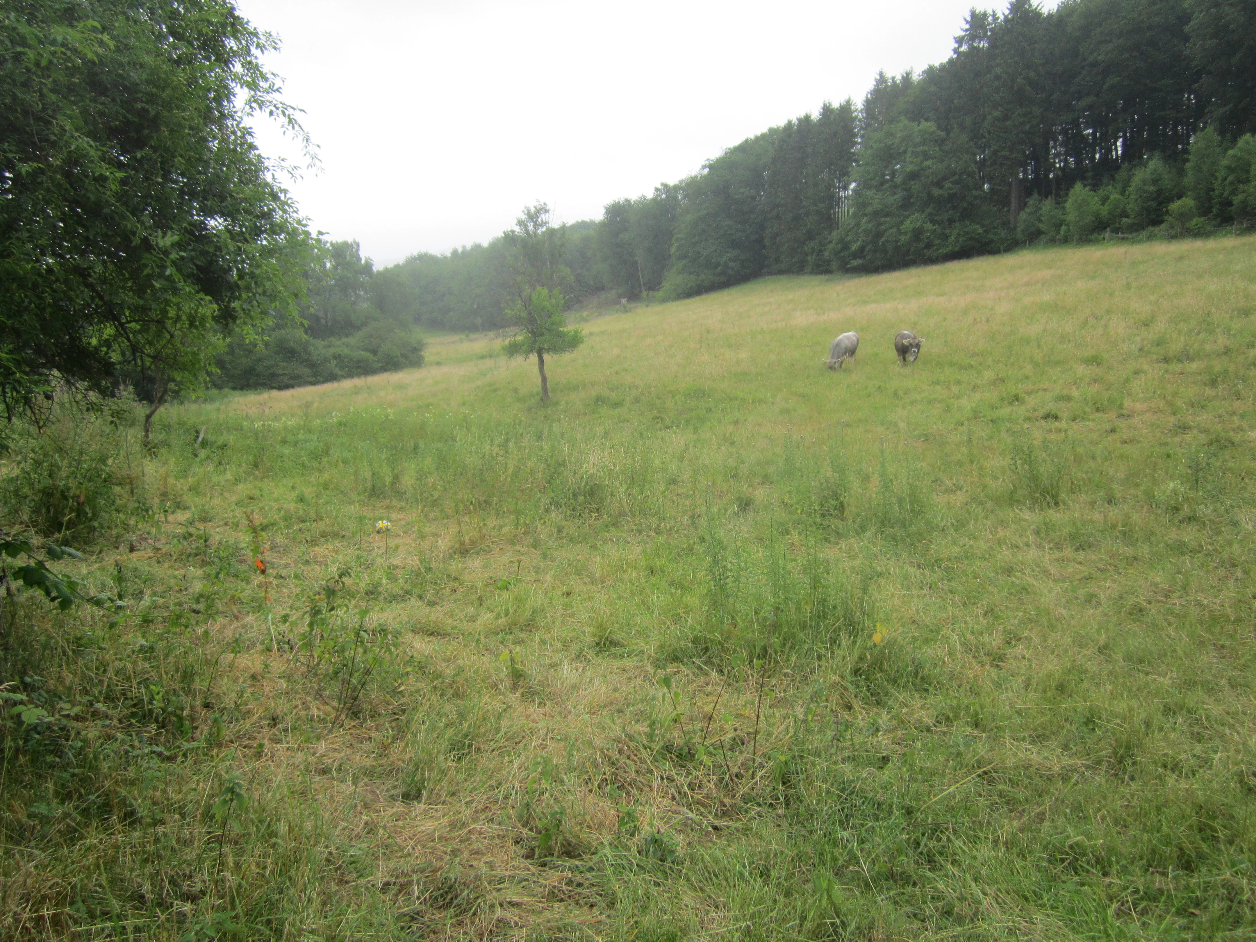
A wide view of a gently sloping grassy meadow in the Oberes Elsetal nature reserve, bordered by a dense forest on the right, with a few grazing animals in the distance.
A view of the open meadows and forest edge in the Oberes Elsetal nature reserve.

Naturschutzgebiet Oberes Elsetal ecosystems, habitats, and plant life

Ecologically, the reserve represents a typical, well-preserved brook headwater system of the central German low mountain ranges. Its habitats include near-natural spring brook channels, marshy seepage areas with pond horsetail and branched bur-reed, wet meadows with marsh marigold and bitter cress, meadowsweet-dominated tall herb fringes, and regularly mown or grazed fattier meadows on slightly drier ground.

Along the brook itself, a linear alder gallery, in places mixed with ash, forms the backbone of the riparian vegetation. Where the valley bends east, this gallery transitions abruptly into a relict oak-hornbeam woodland on the slope above, illustrating how sharply the habitats shift over a short distance when slope angle, soils, and groundwater change.

The combination of open seepage zones, herb fringes, wet and moist grassland, and shoreline woodland makes the reserve ecologically richer than its small size would suggest. The state biotope register specifically highlights the close interlocking of these habitats as the defining feature of the area.

Naturschutzgebiet Oberes Elsetal wildlife and species highlights

The source content does not provide a detailed fauna inventory, but it does emphasize that the reserve was set aside to maintain a brook valley with specially adapted flora and fauna. The protected habitat mosaic, particularly the wet meadows, seepage zones, tall herb fringes, and alder gallery woodland, is well suited to common brookside fauna typical of the Sauerland: dragonflies and other insects along the slow-moving spring brook, amphibians in the marshy depressions and pond horsetail stands, and a typical songbird community of wet woodland edges and orchard slopes.

Because the original German Wikipedia page focuses on vegetation rather than fauna, detailed wildlife section content beyond these habitat-driven expectations would not be reliably supported.

Naturschutzgebiet Oberes Elsetal conservation status and protection priorities

The reserve's conservation significance lies in the preservation of a brook headwater system that still retains many of its traditional features despite being embedded in an agricultural landscape. According to the LANUV biotope register, the site has at least local significance for the Südsauerländer Bergland natural region, because the close interplay between spring brook, wet grassland, tall herb vegetation, and brookside woodland has become increasingly uncommon in the region under modern land use.

Protection aims include preserving existing wet and marshy grassland, restoring structural diversity where elements have simplified, and countering two main pressures: intensification of the remaining fattier meadow parcel, and trampling damage to sensitive spring areas from grazing cattle. Recommended measures include extensive grassland use of the fattier meadow, the long-term maintenance of fallow wet grassland through infrequent mowing cycles, and improved protection of the source areas from livestock impact.

By conserving these features together rather than in isolation, the reserve maintains a small but high-quality example of how brook valleys in farmed Mittelgebirge landscapes can remain ecologically functional.

Naturschutzgebiet Oberes Elsetal cultural meaning and human context

The valley reflects a long history of low-intensity agricultural use in the Sauerland, with cattle grazing on the water meadows, hay harvest on drier grasslands, and small orchard management on the slopes. These traditional practices are themselves part of what the reserve protects: the wet meadows and fallow marshland are described in the official assessment as a living witness of the cultural landscape.

The aging orchard on the upper slope and the alignment of meadows and fallow strips along the brook are direct legacies of this rural land use. Maintaining the site therefore also means sustaining an inherited pattern of farming that has shaped the valley for generations.

Top sights and standout views in Naturschutzgebiet Oberes Elsetal

One of the reserve's strongest features is the unusually tight structural mosaic of habitats along a single short brook valley: spring seepage zones, marshy grassland, meadowsweet tall herb fringes, alder gallery woodland, and a small oak-hornbeam slope woodland all occur within walking distance of each other.

Another distinguishing point is the presence of a particularly well-developed pond horsetail and branched bur-reed community at a floodplain widening, illustrated in official records as a characteristic habitat element of the area. The transition from linear alder riparian woodland to oak-hornbeam forest along the eastern valley bend is also an unusually clear example of a slope-driven vegetation shift in miniature.

Best time to visit Naturschutzgebiet Oberes Elsetal

The source material does not specify seasonal access or visiting logistics, so detailed seasonal recommendations would not be reliably supported. In general, late spring through early summer is the period when wet meadow flowers such as marsh marigold and bitter cress are most visible, and when the meadowsweet tall herb fringes along the Else are at their most expressive. Late summer highlights the taller herb and reed vegetation, while early autumn brings clearer views into the gallery woodland as surrounding grasses shorten.

Monthly climate preview

Long term temperature and precipitation patterns across representative coordinates

Naturschutzgebiet Oberes Elsetal Climate Normals and Monthly Weather Records

Measured historical records track average monthly temperature swings and precipitation rates across a representative point within Naturschutzgebiet Oberes Elsetal. Examining the complete twelve month profile reveals detailed climate normals and deeper seasonal variations for the protected area.
Annual mean9 °C
0 °C18 °C
Jan
Feb
Mar
Apr
May13°
Jun16°
Jul18°
Aug18°
Sep14°
Oct
Nov
Dec
Warmest month
July

18.3 °C

Coolest month
January

0.3 °C

Wettest month
December

3 mm/day

Driest month
April

1.8 mm/day

Park location guide

Geography guide, regional context, and park location map for Naturschutzgebiet Oberes Elsetal

Naturschutzgebiet Oberes Elsetal park geography, regions, and map view in Germany

Understand where Naturschutzgebiet Oberes Elsetal sits in Germany through a broader geographic reading of the surrounding landscape, nearby location context, and its mapped position within the national park landscape.

How Naturschutzgebiet Oberes Elsetal fits into Germany

Germany is a federal republic in Western and Central Europe with a population of over 83 million across sixteen constituent states. It is Europe's largest economy by nominal GDP and a major global exporter and importer. The capital is Berlin, and the country borders Denmark, Poland, Czech Republic, Austria, Switzerland, France, Luxembourg, Belgium, and the Netherlands.

Wider geography shaping Naturschutzgebiet Oberes Elsetal in Germany

Germany is located in Western and Central Europe, spanning 357,022 km². It borders Denmark to the north, Poland and the Czech Republic to the east, Austria and Switzerland to the south, and France, Luxembourg, Belgium, and the Netherlands to the west. The country has coastlines on the Baltic Sea and North Sea to the north, with the Alps located in the southern region.

Map view of Naturschutzgebiet Oberes Elsetal

Use this park location map to pinpoint Naturschutzgebiet Oberes Elsetal in Germany, understand its exact geographic position, and read its mapped placement within the surrounding landscape more clearly.

Pigeon | © OpenStreetMap contributors

Location context for Naturschutzgebiet Oberes Elsetal

North Rhine-Westphalia

Visual reference for brook valleys, riparian woodlands, and habitats

Naturschutzgebiet Oberes Elsetal Photos and Landscape Scenery

Visual documentation of Naturschutzgebiet Oberes Elsetal reveals the structural mosaic of spring seepage zones, wet grasslands, and riparian alder forests. Photographic records illustrate the distinct topography and habitat layering across this protected low mountain brook valley.

A green pasture with a horse standing in the middle distance; a small rustic wooden barn is on the right, with a forested hillside in the background under a cloudy sky.

A wide landscape view of a green meadow in the Oberes Elsetal nature reserve, with scattered trees and gentle hills under an overcast sky.

A wide view of a gently sloping grassy meadow in the Oberes Elsetal nature reserve, bordered by a dense forest on the right, with a few grazing animals in the distance.

Park atlas

Compare regional valley reserves and surrounding low mountain range habitats

Explore Parks Near Naturschutzgebiet Oberes Elsetal and Adjacent Protected Areas

Browsing other protected areas near Naturschutzgebiet Oberes Elsetal reveals similar brook valley ecosystems and regional conservation networks. Comparing adjacent reserves helps place small headwater habitats within the broader topography of the Südsauerländer Bergland.
Nature reserveNorth Rhine-Westphalia
About 7.3 km away#1 closest

East

Heinrich-Bernhard-Höhle Nature Reserve and Karst Landscape in North Rhine-Westphalia

Examining the geology and protection status of the Sauerland karst system

The Heinrich-Bernhard-Höhle represents a unique convergence of conservation designations, functioning as a nature reserve, paleontological monument, and FFH habitat area. Centered on a 192-meter limestone cave network, the site preserves essential subterranean geological structures and surface beech forests within the North Rhine-Westphalia region.

Area
0 km²
Established
1934
Relief
Upland
Access
Highly restricted
Nature reserveNordrhein-Westfalen
About 7.6 km away#2 closest

Northeast

Naturschutzgebiet Schlänke: Woodland Conservation in the Märkischer Kreis Region

Protected beech-forest terrain and spring-blooming flora

Spanning roughly 0.6 hectares, Naturschutzgebiet Schlänke is a focused nature reserve dedicated to the preservation of native deciduous woodland. The site occupies a north-facing slope, creating specific moisture conditions that sustain a notable population of spring snowflakes, marking it as a significant botanical patch within the broader forested landscape of Plettenberg.

Area
0.006 km²
Established
1985
Relief
Upland
Climate
Temperate
A watercolor painting showing a tranquil reservoir surrounded by rolling green hills, forests, and grassy shorelines under a pale sky.
Protected areaNordrhein-Westfalen
About 11 km away#3 closest

South

Listertalsperre Reservoir and Protected Forest Landscape in North Rhine-Westphalia

Historic gravity dam and regional hydrologic landmark.

Explore the detailed geography of Listertalsperre, a unique reservoir site characterized by its historic stone masonry dam and role in the regional water supply. This protected area offers insight into the engineered landscapes of the Sauerland, featuring forest-covered ridges and specialized waterfowl habitats that define this segment of the regional watershed.

Area
1.68 km²
Established
1912
Relief
Upland
Climate
Temperate
A soft watercolor illustration of a landscape featuring green rolling hills, a meandering river or stream, and distant low mountains under a light sky.
Nature reserveNorth Rhine-Westphalia
About 13 km away#4 closest

Southeast

Naturschutzgebiet Ahauser Klippen und Stausee: Protected Area and Limestone Landscape Atlas

A key nature reserve in the Attendorn-Elsper limestone basin of North Rhine-Westphalia.

Naturschutzgebiet Ahauser Klippen und Stausee is a compact yet ecologically rich nature reserve defined by carbonate geology and steep cliff biotopes. The area serves as a core refugial site within the Sauerland, integrating diverse forest stands, rare fissure vegetation, and essential waterbird resting zones at the reservoir edge.

Area
0.239 km²
Established
2003
IUCN
IV
Relief
Upland
A horizontal watercolor painting depicting a gentle, light-filled landscape featuring soft green trees, rolling hills, and a small water feature.
Nature reserveNorth Rhine-Westphalia
About 14 km away#5 closest

East

Hohe Ley Nature Reserve: Limestone Cliffs and Forest Geography in North Rhine-Westphalia

Protected calcareous woodland and raptor breeding habitat

This nature reserve in the Sauerland region features a prominent limestone cliff and a complex mosaic of woodruff and wavy hair grass beech forests. As part of a larger European habitat network, the reserve supports rare dry grassland and ravine woodland communities. Its topography provides critical nesting sites for eagle owls and common kestrels, anchoring a valuable ecological corridor within the local landscape.

Area
0.498 km²
Established
1981
A horizontal watercolor painting depicting a soft-toned landscape with a winding river, grassy banks, and distant rolling hills in light pastel colors.
Protected landscapeMaerkischer Kreis
About 14 km away#6 closest

North

Landschaftsschutzgebiet Balve Mittleres Hönnetal Protected Landscape and Map

Regional geography and forested valley terrain in Maerkischer Kreis

Covering roughly 4,745 hectares, this protected landscape is defined by its extensive beech and spruce woodlands alongside the Hönne river. The area highlights the unique proximity between traditional forest and agricultural zones and residential edges. This atlas entry details the topographic profile and land use patterns found across this distinctive German protected territory.

Area
47.457 km²
Established
1989
Relief
Upland
Climate
Temperate
A soft watercolor illustration of a wide river landscape with rolling green hills in the background and grassy riverbanks in the foreground.
Nature reserveNordrhein-Westfalen
About 16 km away#7 closest

Northwest

Naturschutzgebiet Pragpaul: Nature Reserve and Protected Lenne Valley Landscapes

Geographic atlas and protected area boundary overview

Naturschutzgebiet Pragpaul preserves a narrow, steeply sloping strip of forest between Altena and Nachrodt-Wiblingwerde. The site integrates rocky cliff outcrops, dense beech woodlands, and near-natural riverine sections along the Lenne, forming a vital component of the Schluchtwälder im Lennetal protected network.

Area
0.7 km²
Established
1999
IUCN
IV
Nature reserveKreis Olpe
About 16 km away#8 closest

East

Wunderwäldchen Nature Reserve: Mapping Botanical Biodiversity in the District of Kreis Olpe

A cross-boundary woodland refuge in the Sauerland region

Wunderwäldchen is a protected nature reserve spanning the border of two municipalities in Kreis Olpe. This small beech and oak woodland serves as a critical botanical refuge, sustaining rare plant species on its carbonate-enriched soils. It remains a key example of how even minute, fragmented habitats provide essential ecological value within the densely managed landscapes of the Lenne valley.

Area
0.007 km²
Established
1981
IUCN
IV
Relief
Upland

Common questions about visiting, size, designation, and location context for Naturschutzgebiet Oberes Elsetal

Naturschutzgebiet Oberes Elsetal FAQs for park facts, access, geography, and protected area context

Find quick answers about Naturschutzgebiet Oberes Elsetal, including protected-area facts, park geography, trail and visitor context, and how the park fits into its surrounding country and regional landscape.
MoriAtlas Explorer

Continue Your Protected Areas Search Across the Global Atlas

Deepen your exploration by continuing the structured search for national parks and protected areas worldwide. Utilize the comprehensive filtering capabilities to compare different conservation landscapes and refine your understanding of global park geography. Discover more about the distribution and characteristics of protected natural areas.

Global natural geography