
Mori Atlas logo
Nature reserveNaturschutzgebiet Ölfetal

Examining the ecological boundaries and meadow mosaic of this North Rhine-Westphalian protected landscape.

Naturschutzgebiet Ölfetal: A Protected Stream Valley and Grassland Reserve in the Sauerland

Naturschutzgebiet Ölfetal encompasses roughly 12 hectares of species-rich grassland along the Ölfe stream in the Medebach area of North Rhine-Westphalia. This protected nature reserve preserves a vital riparian mosaic of wet and dry meadow habitats, serving as a functional component of the regional Medebacher Bucht bird protection area. The landscape is characterized by its gentle stream-valley terrain, forming a fragmented yet ecologically significant corridor near the Hessian border.

nature reservegrassland valleymeadow streamwet meadowEuropean Bird Protection AreaSauerland
A flat-style digital illustration showing a meandering river flowing through a green valley with a meadow, coniferous trees, and distant pinkish-hued mountains under a sunlit sky.

Naturschutzgebiet Ölfetal

Nature reserve

Park overview

Structured park overview, official facts, and landscape profile for Naturschutzgebiet Ölfetal

Naturschutzgebiet Ölfetal park facts, protected area profile, and essential visitor context

Review the core facts for Naturschutzgebiet Ölfetal, including designation, size, terrain, visitor scale, habitats, and operating context in one park-focused overview.

About Naturschutzgebiet Ölfetal

Naturschutzgebiet Ölfetal is a small but ecologically focused nature reserve in the eastern Sauerland region of western Germany. It lies within the municipal territory of Medebach, in the Hochsauerlandkreis district of North Rhine-Westphalia, and consists of two separate grassland sections that together trace parts of the small Ölfe stream as it flows through a shallow valley near the village of Dreislar. The western section reaches the boundary with the adjacent town area of Hallenberg, while the eastern section extends all the way to the state border between North Rhine-Westphalia and Hesse.

The character of the reserve is shaped by a stream-side meadow landscape: a narrow valley in which the Ölfe creates the central hydrological thread around which the protected vegetation develops. The mix of moist riparian conditions near the stream and drier upland edges produces ecological transitions that are typical for old valley grassland habitats in the central German uplands: wet meadows against drier hay meadows, reed-like flushes against tall herb patches, and scrubby margin transitions at the field edges. The reserve's modest size is precisely what makes this habitat compact and worth preserving, since specialists of these transitional zones are sensitive to even small changes in land use.

The site's value extends beyond its own footprint: it is part of the European Bird Protection Area Medebacher Bucht, a larger network of stream-valley and grassland reserves across the Medebach area, and it adjoins the Mahlbach- und Ölfetalsystem nature reserve in neighboring Hallenberg. This puts it within a regional complex of stream valleys that together provide continuous habitat corridors for birds, amphibians, and meadow flora at the western edge of the Rothaargebirge uplands.

Quick facts and research context for Naturschutzgebiet Ölfetal

Naturschutzgebiet Ölfetal is a designated nature reserve in the Hochsauerlandkreis district of North Rhine-Westphalia, administered as part of the Medebach municipal landscape planning framework. It was officially designated as a protected area in 2003 and lies within the city area of Medebach, west and southeast of Dreislar.

The reserve covers roughly 12 hectares split into two distinct sections, with the eastern section reaching the border with Hesse and the western section bordering the town area of Hallenberg. It is part of the European Bird Protection Area Medebacher Bucht and shares a continuous stream corridor with the adjacent Mahlbach- und Ölfetalsystem nature reserve to the west.

Protection and recognition

Documented protection scope and official recognition details for Naturschutzgebiet Ölfetal

Naturschutzgebiet Ölfetal Protection Status and Terrestrial Conservation Data

Terrestrial protection status and designation records for Naturschutzgebiet Ölfetal outline its formal conservation framework. Verified facts detail the protected area management scope and international recognition standing without unverified claims.

Protection details

Protection scope
Terrestrial
Park context

Deeper park guide and search-rich context for Naturschutzgebiet Ölfetal

Naturschutzgebiet Ölfetal history, landscape, wildlife, and travel context

Explore Naturschutzgebiet Ölfetal through its history, landscape character, ecosystems, wildlife, conservation priorities, cultural context, and seasonal travel timing in a structured park guide built for atlas discovery and search intent.

Why Naturschutzgebiet Ölfetal stands out

Naturschutzgebiet Ölfetal is best known for protecting species-rich grassland along the Ölfe stream, where a narrow valley meadow system preserves both wet marshy vegetation and drier meadow flora in close proximity. Its botanical inventory includes a notably long list of meadow and wetland plant species recorded by the North Rhine-Westphalian state office for nature, environment and consumer protection, indicating a high habitat quality for this kind of small protected valley. The reserve is also valued as a breeding and foraging site for typical grassland and shrubland birds associated with traditional low-intensity agricultural landscapes in central Germany. Its position within the broader Medebacher Bucht bird protection area connects it functionally with a wider regional network of stream-valley and grassland reserves across the eastern Sauerland.
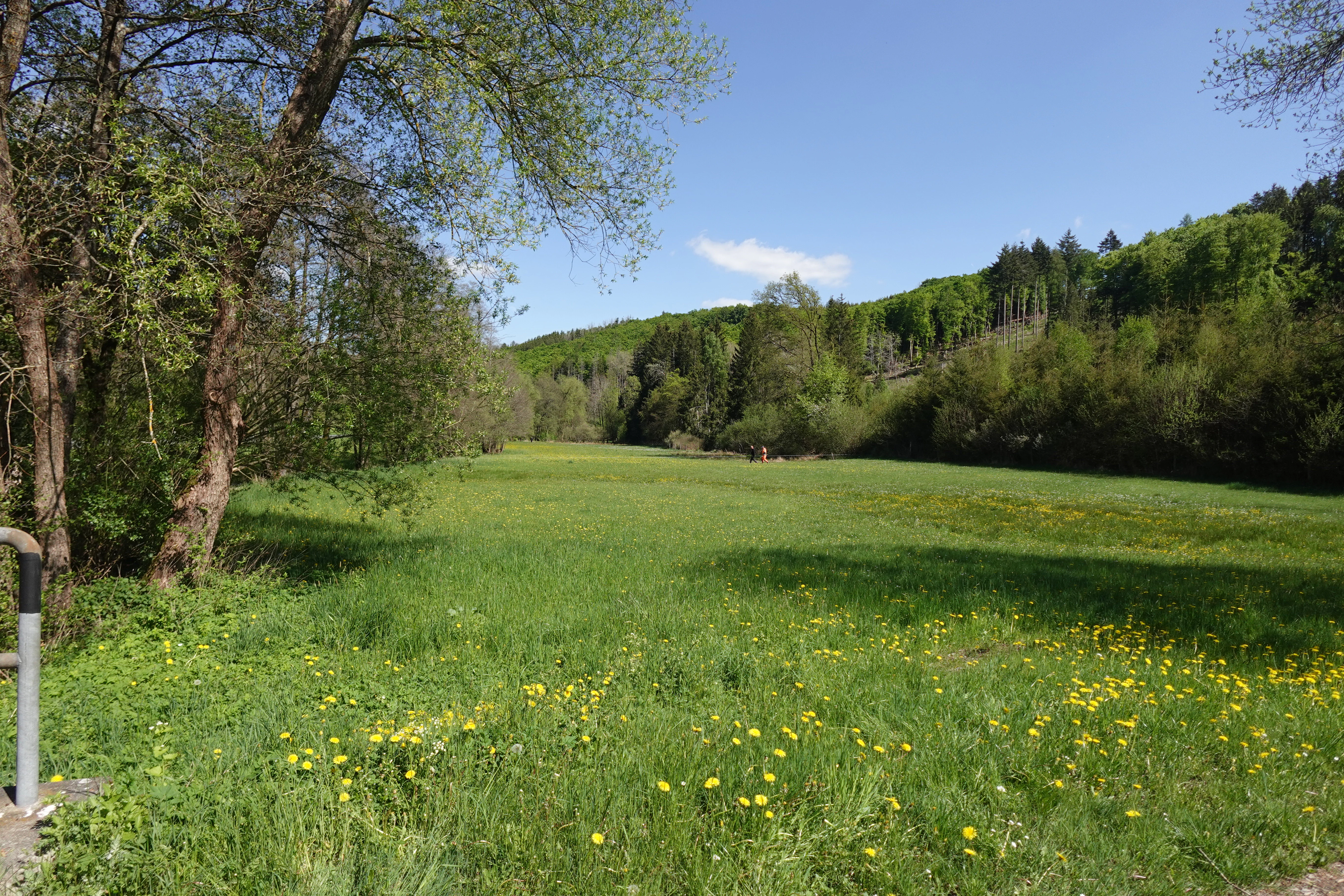
A landscape view of a green valley with a meadow full of yellow wildflowers in the foreground, flanked by mature trees on the left and a forested hillside in the background under a blue sky.
A scenic view of the lush, green Ölfe Valley with scattered yellow wildflowers.

Naturschutzgebiet Ölfetal history and protected-area timeline

The area now known as Naturschutzgebiet Ölfetal was officially designated as a nature reserve in 2003, when the Hochsauerlandkreis district adopted the Landscape Plan for the Medebach area. The 2003 plan codified the protected status of the grassland sections of the Ölfe stream valley west and southeast of Dreislar, anchoring them within the broader Grünlandtäler (meadow-valley) network of the district.

Prior to formal designation, the valley was valued regionally for its species-rich meadows and its stream-side plant communities, conditions that are typical of long-cultivated low-intensity agricultural landscape in the Sauerland. Recognized along with the protection were concerns about rarity, distinctiveness, and scenic character, which are the standard criteria under which German nature reserves are formally designated. Since 2003, the reserve has functioned as a stable protected component of the Medebacher Bucht European Bird Protection Area.

Naturschutzgebiet Ölfetal landscape and geographic character

The landscape of Naturschutzgebiet Ölfetal is a typical Sauerland stream valley: a narrow, gently sloping meadow corridor shaped by the Ölfe stream and framed by surrounding agricultural land and forest patches beyond the reserve boundaries. The valley floor is characterized by open grassland that follows the course of the water, with subtle transitions between the wet, stream-adjacent zone and the drier upper meadow surfaces.

The two sections of the reserve sit on opposite ends of this valley system, creating a fragmented but connected protected corridor. The western section transitions toward the landscape of Hallenberg and connects ecologically to the adjacent Mahlbach- und Ölfetalsystem nature reserve, which protects a closely related stream valley. The eastern section reaches the Hessian border, placing it at the regional divide between North Rhine-Westphalia and Hesse.

Subtle relief and watercourses dominate the visual character of the site. There are no dramatic cliffs or alpine features; instead, the interest of the landscape lies in its quiet, layered mosaic of meadow types, the gentle course of the Ölfe, and the broader rural upland framing in which the reserve sits. The surrounding land is part of the eastern Rothaargebirge foothills, where woodland edge, pasture, and small stream valleys alternate in a finely fragmented pattern.

Naturschutzgebiet Ölfetal ecosystems, habitats, and plant life

The ecological identity of Naturschutzgebiet Ölfetal is rooted in its stream-side grassland system, supporting a remarkable density of meadow plant species for such a small area. The botanical inventory recorded by the North Rhine-Westphalian state office includes characteristic species of both wet and dry meadows, along with ruderal and edge-of-habitat species that develop where field margins meet the protected zone. This indicates a long-standing low-intensity management regime that has preserved a high diversity of herbaceous plants.

Wetland and moisture-loving plants are particularly notable: species such as Sumpf-Dotterblume (marsh marigold), Sumpf-Vergissmeinnicht (marsh forget-me-not), Wasser-Minze (water mint), Bachbunge (brooklime), Echte Brunnenkresse (watercress), Sumpf-Helmkraut (marsh skullcap), Sumpf-Schachtelhalm (marsh horsetail) and Schmalblättriges Wollgras (narrow-leaved cottongrass) indicate the importance of the Ölfe's riparian margin. These wet-zone plants coexist with drier meadow types, including Magerwiesen-Margerite (oxeye daisy of poor meadows), Wiesen-Flockenblume (knapweed), Wiesen-Bocksbart (goat's-beard), and the orchid Breitblättriges Knabenkraut (broad-leaved marsh orchid).

Non-native as well as native edge species further enrich the habitat structure. Plants such as Hopfen (hop), Echtes Springkraut (touch-me-not), Moschus-Malve (musk mallow), and Heide-Nelke (heath pink) illustrate the diverse microhabitats within the transition between forest edge, scrub, meadow, and stream. The variety of species present, particularly among threatened and specialist plants, is what gives the reserve its habitat quality.

Naturschutzgebiet Ölfetal wildlife and species highlights

The wildlife profile of Naturschutzgebiet Ölfetal is dominated by birds and insects typical of low-intensity grassland landscapes in central Germany. Breeding and visiting bird species recorded by the state environmental office include Amsel (blackbird), Bachstelze (white wagtail), Baumpieper (tree pipit), Bluthänfling (linnet), Buchfink (chaffinch), Dorngrasmücke (common whitethroat), Eichelhäher (jay), Elster (magpie), Feldlerche (skylark), Fitis (willow warbler), Gartengrasmücke (garden warbler), Goldammer (yellowhammer), Grünfink (greenfinch), Heckenbraunelle (dunnock), Mönchsgrasmücke (blackcap), Neuntöter (red-backed shrike), Rabenkrähe (carrion crow), Rebhuhn (grey partridge), Ringeltaube (wood pigeon), Rohrammer (reed bunting), Rotkehlchen (robin), Sumpfrohrsänger (marsh warbler), Turteltaube (turtle dove), Wacholderdrossel (fieldfare), Wachtel (quail), Weidenmeise (willow tit), Zaunkönig (wren), and Zilpzalp (chiffchaff).

The presence of Wachtel and Rebhuhn is particularly notable because both species have undergone significant declines in central European farmland. The recorded Neuntöter (red-backed shrike), which uses thorny scrub and tall herb borders, similarly points to a habitat with good structural diversity. Older records also note the Braunkehlchen (whinchat) as a former breeder in the nearby Pitzfeld area, indicating that some of the broader regional grassland complex has shifted in its bird community over recent decades, a pattern that aligns with regional declines in meadow-nesting species.

Insect fauna includes the Blauflügel-Prachtlibelle (a damselfly of small streams), the Gemeiner Grashüpfer, Roesels Beißschrecke, Nachtigall-Grashüpfer, and Zwitscherschrecke grasshopper species, all of which depend on warm, unimproved meadow conditions. Amphibians are represented by the Grasfrosch (common frog), which uses the stream corridor and adjacent wet flushes for breeding.

Naturschutzgebiet Ölfetal conservation status and protection priorities

From a conservation standpoint, Naturschutzgebiet Ölfetal is a textbook example of a small, focused protected area: a modest site whose significance is disproportionate to its size because it preserves a habitat that is highly vulnerable to land-use intensification. The site is officially designated as a Naturschutzgebiet under the standard German criteria of rarity, distinctiveness, and scenic character, with specific reference to the protection of grassland, stream, and species inventory.

Its integration into the European Bird Protection Area Medebacher Bucht elevates the reserve from a local protection status to a contribution within a transnational network of protected bird habitats. Within that network, it functions as one of the connecting stream-valley reserves that together maintain a continuous grassland and wetland habitat complex across the eastern Sauerland. Conservation value therefore lies both in its specific botanical and ornithological richness and in its role as a link in this broader regional corridor.

The reserve's value is reinforced by the wide range of plant species it shelters, including several that are individually noted as rare or threatened in the regional record. Protecting these species requires ongoing low-intensity management: continued hay-meadow agriculture, careful grazing, and the avoidance of nutrient input or drainage, all of which would alter the delicate balance between wet and dry meadow zones that defines the site.

Naturschutzgebiet Ölfetal cultural meaning and human context

The cultural context of Naturschutzgebiet Ölfetal is closely tied to the long agricultural tradition of the Sauerland meadows. The valley's grassland character is the product of centuries of human use as hay meadow and light pasture, and the preservation of its botanical richness depends directly on the continuation of low-intensity, traditional land management in the area.

Within Medebach's cultural landscape, the reserve represents one of many small, locally integrated stream-valley protections that the Hochsauerlandkreis has formalized over recent decades, reflecting a regional awareness of how traditional landscapes shape identity and ecological quality at once. The naming of the area, derived from the small Ölfe stream itself, is shared in the adjacent Mahlbach- und Ölfetalsystem nature reserve, indicating a strong local sense of place rooted in the region's water geography.

Top sights and standout views in Naturschutzgebiet Ölfetal

A species-rich Sauerland stream-valley reserve along the Ölfe near Dreislar, with two protected sections totaling roughly 12 hectares in the Medebach area.

Part of the European Bird Protection Area Medebacher Bucht, with documented breeding populations of grassland and shrubland birds including Rebhuhn, Wachtel, Rohrammer, Sumpfrohrsänger, and Neuntöter.

Noted for a long botanical inventory of meadow, wetland, and edge species, including threatened grassland plants such as Breitblättriges Knabenkraut, Trollblume, Heide-Nelke, and the orchid-rich wet meadow flora of the Sauerland.

Formally designated as a nature reserve in 2003 through the Hochsauerlandkreis Landscape Plan for Medebach, and contiguous with the Hallenberg-side Mahlbach- und Ölfetalsystem reserve at the western edge of the Ölfe catchment.

Best time to visit Naturschutzgebiet Ölfetal

The most rewarding time to experience the ecological character of Naturschutzgebiet Ölfetal is late spring through summer, when the valley meadows reach their peak flowering and the highest number of breeding bird species are detectable. Visits in late May and June typically offer the densest plant display, especially of wet meadow and riparian species, while mid-summer is best for observing adult birds actively foraging along the stream margins and field edges.

Late summer to early autumn brings a quieter phase, with mature grass swards, ripening seeds attracting finches and buntings, and the most sober depiction of the meadow mosaic itself. Winter conditions can make the lightly structured terrain easy to read across, but the access conditions and the muted biological signals make the site far less rewarding outside the warmer half of the year.

Monthly climate preview

Track monthly temperature variations and precipitation averages across the protected terrain

Naturschutzgebiet Ölfetal Climate Normals and Long-Term Weather Patterns

Representative coordinate records show measured monthly temperature swings from sub-zero winter minimums to warm summer maximums alongside consistent daily precipitation rates. Examining the full twelve-month climate profile reveals comprehensive long-term averages across the protected area.
Annual mean8 °C
-1 °C18 °C
Jan-1°
Feb
Mar
Apr
May12°
Jun15°
Jul18°
Aug17°
Sep13°
Oct
Nov
Dec
Warmest month
July

17.6 °C

Coolest month
January

-1 °C

Wettest month
July

2.6 mm/day

Driest month
April

1.7 mm/day

Park location guide

Geography guide, regional context, and park location map for Naturschutzgebiet Ölfetal

Naturschutzgebiet Ölfetal park geography, regions, and map view in Germany

Understand where Naturschutzgebiet Ölfetal sits in Germany through a broader geographic reading of the surrounding landscape, nearby location context, and its mapped position within the national park landscape.

How Naturschutzgebiet Ölfetal fits into Germany

Germany is a federal republic in Western and Central Europe with a population of over 83 million across sixteen constituent states. It is Europe's largest economy by nominal GDP and a major global exporter and importer. The capital is Berlin, and the country borders Denmark, Poland, Czech Republic, Austria, Switzerland, France, Luxembourg, Belgium, and the Netherlands.

Wider geography shaping Naturschutzgebiet Ölfetal in Germany

Germany is located in Western and Central Europe, spanning 357,022 km². It borders Denmark to the north, Poland and the Czech Republic to the east, Austria and Switzerland to the south, and France, Luxembourg, Belgium, and the Netherlands to the west. The country has coastlines on the Baltic Sea and North Sea to the north, with the Alps located in the southern region.

Map view of Naturschutzgebiet Ölfetal

Use this park location map to pinpoint Naturschutzgebiet Ölfetal in Germany, understand its exact geographic position, and read its mapped placement within the surrounding landscape more clearly.

Pigeon | © OpenStreetMap contributors

Location context for Naturschutzgebiet Ölfetal

North Rhine-Westphalia

Visual exploration of protected grassland habitats, riparian zones, and valley meadow terrain

Naturschutzgebiet Ölfetal Photos and Stream Valley Landscape Scenery

Visual documentation captures the gentle valley topography, meandering stream corridors, and diverse meadow flora defining this Sauerland reserve. Studying these protected landscapes reveals the subtle ecological gradients and quiet upland terrain characteristic of the region.

A landscape view of a green valley with a meadow full of yellow wildflowers in the foreground, flanked by mature trees on the left and a forested hillside in the background under a blue sky.

Park atlas

Compare adjacent stream valleys and regional reserves across the eastern Sauerland uplands

Explore Other Parks Near Naturschutzgebiet Ölfetal and Surrounding Protected Landscapes

Discover protected areas near the surrounding region to compare valley meadow habitats, stream corridors, and upland bird protection zones. Continuing exploration from Naturschutzgebiet Ölfetal reveals a broader network of connected reserves across the central German landscape.
A watercolor painting of a gentle river valley with soft green hills, wildflowers in the foreground, and a wooden fence line.
Nature reserveNorth Rhine-Westphalia
About 4.4 km away#1 closest

Northeast

Naturschutzgebiet Orketal Nature Reserve: Protected Brook Valley and Floodplain Geography

Regional conservation landmark in North Rhine-Westphalia, Germany.

Naturschutzgebiet Orketal protects a continuous stretch of the Orke brook, featuring a rich assembly of floodplain meadows and nutrient-poor grassland habitats. Documented for its role in maintaining healthy freshwater ecosystems and supporting breeding populations of kingfishers and grey wagtails, the reserve forms a critical link in the broader Medebacher Bucht ecological network.

Area
1.98 km²
Established
1999
Climate
Temperate
Scope
Terrestrial
Nature reserveNorth Rhine-Westphalia
About 9.8 km away#2 closest

West

Naturschutzgebiet Ahretalsystem: Mapped Protected Brook Valley and Low Mountain Landscape

Ecological terrain analysis of the Sauerland uplands

Naturschutzgebiet Ahretalsystem protects a refined valley system in the Rothaargebirge, showcasing the intricate interplay between near-natural stream courses and traditional mountain pastures. This reserve serves as a key site for montane brook conservation, hosting significant botanical populations within its mosaic of wet meadows and dry slope grasslands across the Winterberg landscape.

Area
0.358 km²
Established
2008
Relief
Mountain
Climate
Temperate
Nature reserveNorth Rhine-Westphalia
About 9.8 km away#3 closest

North

Naturschutzgebiet Oberes Dittelsbachtal - Klokenbruch: Regional Protected Area Map

Sauerland brook valley and meadow landscape

This nature reserve protects 14 hectares of the upper Dittelsbach stream and surrounding damp grasslands. The landscape is defined by its compact valley form, spring-fed mires, and traditional grazing patches, serving as an important link for bird protection in the Medebacher Bucht region of North Rhine-Westphalia.

Area
0.139 km²
Established
2003
Scope
Terrestrial
Water
Major water bodies
A horizontal watercolor painting depicting a soft green landscape with rolling hills, a meandering stream, and light vegetation.
Nature reserveNordrhein-Westfalen
About 10 km away#4 closest

Northwest

Naturschutzgebiet Schluchtwald Helle: Ravine Forest Geography and Protected Area Overview

Mapping the Sauerland upland streams and old-growth woodland habitat

This protected nature reserve spans roughly 58 hectares of steep, incised terrain near Winterberg, Germany. It safeguards the headwaters of the Helle stream, providing a stable, humid microclimate that fosters high biodiversity within a compact, moss-covered woodland setting that remains free from active human management.

Area
0.581 km²
Established
2008
IUCN
IV
Relief
Upland
Nature reserveHochsauerlandkreis
About 11 km away#5 closest

North

Naturschutzgebiet Almecke: Geographic Atlas and Protected Landscape Overview

A preserved hedgerow mosaic in the Hochsauerlandkreis region.

Naturschutzgebiet Almecke is a significant nature reserve characterized by its formal inclusion in the European bird protection area network. The site offers a concentrated look at traditional cultural landscapes, specifically the interaction between steep valley topography, contour-following hedgerows, and dry upland pastures. This protected area serves as an essential case study in localized conservation geography and habitat structure within the wider Sauerland region.

Area
0.058 km²
Established
2003
Relief
Upland
Scope
Terrestrial
Nature reserveNorth Rhine-Westphalia
About 13 km away#6 closest

West

Naturschutzgebiet Odeborn-Talsystem: Protected Valley and Meadow Geography

Nature reserve terrain in the Rothaar Mountains of North Rhine-Westphalia.

Naturschutzgebiet Odeborn-Talsystem protects a vital valley system featuring traditionally managed mountain grasslands and the winding course of the Odeborn stream. This nature reserve provides essential habitat connectivity within the broader North Rhine-Westphalia region, representing a unique intersection of stream, forest, and open-field topography managed for conservation.

Area
0.575 km²
Established
2008
IUCN
IV
Relief
Upland
Nature reserveNorth Rhine-Westphalia
About 13 km away#7 closest

Northwest

Naturschutzgebiet Oberes Ruhrtal: Mapping the Sauerland Headwater Valley Landscape

Protected grassland and river valley geography

Discover the topography and protected boundaries of Naturschutzgebiet Oberes Ruhrtal. This nature reserve in North Rhine-Westphalia preserves a classic headwater valley, where the young Ruhr meanders through nutrient-poor meadows, wet grasslands, and varied riparian terrain, offering a clear example of traditional agricultural landscape conservation.

Area
0.553 km²
Established
2008
IUCN
IV
Relief
Upland
Nature reserveWaldeck-Frankenberg
About 13 km away#8 closest

North

Naturschutzgebiet Jägers Weinberg: Geographic Profile of a Protected Upland Wetland

A mapped nature reserve in the Waldeck-Frankenberg district of northern Hesse

Naturschutzgebiet Jägers Weinberg is a protected wetland landscape in northern Hesse, Germany. This area preserves a rare combination of raised bog and birch swamp forest, functioning as a vital botanical refuge in the Waldeck-Frankenberg district. Its mapped boundaries highlight a specialized ecological site that offers clear insights into the micro-topography and natural history of the local Upland terrain.

Area
0.254 km²
Established
1979
IUCN
IV
Relief
Upland

Common questions about visiting, size, designation, and location context for Naturschutzgebiet Ölfetal

Naturschutzgebiet Ölfetal FAQs for park facts, access, geography, and protected area context

Find quick answers about Naturschutzgebiet Ölfetal, including protected-area facts, park geography, trail and visitor context, and how the park fits into its surrounding country and regional landscape.
MoriAtlas Explorer

Continue Your Protected Areas Search Across the Global Atlas

Deepen your exploration by continuing the structured search for national parks and protected areas worldwide. Utilize the comprehensive filtering capabilities to compare different conservation landscapes and refine your understanding of global park geography. Discover more about the distribution and characteristics of protected natural areas.

Global natural geography