
Mori Atlas logo
Nature reserveNaturschutzgebiet Opspring

A compact forest nature reserve protecting the headwaters of the Grafschaft stream and its side brooks

Naturschutzgebiet Opspring: Mapped Boundaries and Protected Stream Valley Geography in Nordrhein-Westfalen

(Naturschutzgebiet HSK-554 Opspring)

Naturschutzgebiet Opspring occupies three distinct, forested parcels within the narrow, V-shaped valleys of the Schmallenberg municipality. This nature reserve safeguards critical headwater ecosystems, where north-facing slopes and beech-dominated ravines provide a stable, moist microclimate. By mapping these specialized woodlands, we trace the essential role of this site within the wider conservation network of the Rothaar foothills in Germany.

headwater forestbeech foreststream valleynature reserveSauerlandRothaar foothills
A flat-style vector illustration showing a mountainous forest landscape with a flowing stream, a small waterfall in the distance, and tall pine trees under a clear sky.

Naturschutzgebiet Opspring

Nature reserve

Park overview

Structured park overview, official facts, and landscape profile for Naturschutzgebiet Opspring

Naturschutzgebiet Opspring park facts, protected area profile, and essential visitor context

Review the core facts for Naturschutzgebiet Opspring, including designation, size, terrain, visitor scale, habitats, and operating context in one park-focused overview.

About Naturschutzgebiet Opspring

Naturschutzgebiet Opspring is a small but ecologically focused nature reserve in the central Sauerland, in the municipality of Schmallenberg within the Hochsauerlandkreis of North Rhine-Westphalia. With an area of just 11.7 hectares, it is a textbook example of the kind of compact, geomorphologically distinct protection area that is typical of Germany's Naturschutzgebiet system, where small parcels of forest, valley, or wetland are individually safeguarded for their ecological and landscape value.

The reserve lies southeast of the village of Grafschaft, where the land rises into the forested ridges that form the watershed between the Lenne and its tributaries. Opspring consists of three separate but adjacent land parcels, all of them occupying narrow, steep-sided valley bottoms and slopes. These parcels include the headwater zone of the Grafschaft stream itself, a tributary of the Lenne, and the headwaters of two unnamed side brooks known locally as Bauke and N.N.

Ecologically, Opspring is valued primarily for its forest communities. The north-facing valley slopes are dominated by European beech (Rotbuche) with scattered Norway spruce (Rotfichte), while the lower rocky sections support a more shade-tolerant, ravine-like woodland type (Schatthangwald) featuring sycamore maple (Bergahorn). These microclimatically cool, moist conditions, combined with stable groundwater seeps and spring influence, create habitat for several regionally uncommon plant species.

Designated in 2008 through the Landschaftsplan Schmallenberg Südost, the reserve is managed by the lower landscape authority of the Hochsauerlandkreis. Its protective designation rests on the German standard recognition of rarity, distinctive character, and scenic beauty, and its conservation focus is squarely on preserving the forest stand together with its associated species assemblage.

Quick facts and research context for Naturschutzgebiet Opspring

Naturschutzgebiet Opspring is a 11.7 hectare nature reserve located southeast of the village of Grafschaft in the Schmallenberg municipal area of the Hochsauerlandkreis, in the German state of North Rhine-Westphalia. It carries the official designation HSK-554 and falls within IUCN Category IV as a Habitat/Species Management Area, reflecting its focus on conserving valued forest and headwater habitats rather than large-scale wilderness.

The reserve was formally designated in 2008 through the Landschaftsplan Schmallenberg Südost landscape plan by the Hochsauerlandkreis, and is administered by the district's lower landscape authority (Untere Landschaftsbehörde). Its purpose is to protect forested valley habitat along the headwaters of the Grafschaft stream and two of its tributaries, including endangered plant species documented by the state agency for nature, environment, and consumer protection of North Rhine-Westphalia.

Protection and recognition

Explore documented terrestrial conservation metrics and official recognition records

Naturschutzgebiet Opspring Protection Status and International Recognition

Terrestrial protection status and formal designation records outline the conservation framework established for Naturschutzgebiet Opspring. Documented administrative parameters and database registry entries provide clear context for ongoing environmental preservation efforts.

Protection details

Protection scope
Terrestrial
WDPA ID
389857
Park context

Deeper park guide and search-rich context for Naturschutzgebiet Opspring

Naturschutzgebiet Opspring history, landscape, wildlife, and travel context

Explore Naturschutzgebiet Opspring through its history, landscape character, ecosystems, wildlife, conservation priorities, cultural context, and seasonal travel timing in a structured park guide built for atlas discovery and search intent.

Why Naturschutzgebiet Opspring stands out

Opspring is best known as a compact forest reserve safeguarding the spring and upper catchment of the Grafschaft stream and two of its side brooks. Its quiet, north-facing wooded valleys, shallow rocky slopes, and mixed beech-spruce forests make it a representative example of the small, ecologically focused nature reserves typical of the Sauerland uplands. The reserve is also notable for the documented presence of uncommon forest and woodland-floor plant species, giving it botanical significance far beyond its modest size. Together with neighboring protected areas in Schmallenberg, it forms part of a tightly woven network of Holz und Quellbach reserves across the southern Rothaar foothills.
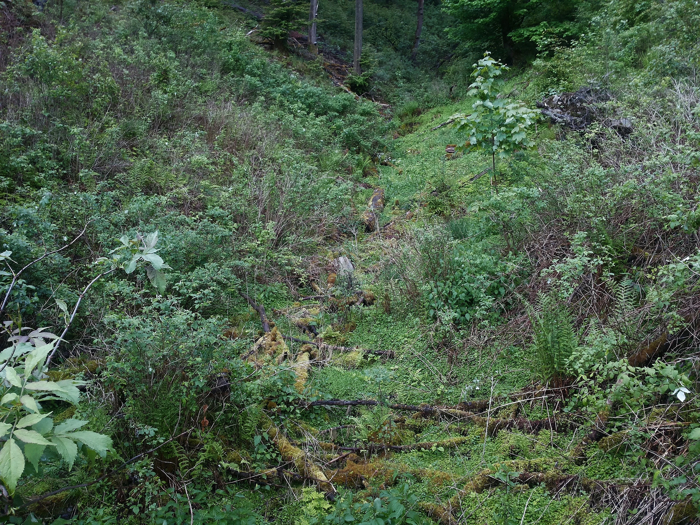
A small stream flows through a lush green ravine with thick vegetation, ferns, and mossy ground.
A small spring brook flowing through a forested ravine in the Opspring nature reserve.

Naturschutzgebiet Opspring history and protected-area timeline

The Naturschutzgebiet Opspring was officially designated as a protected area in 2008. Its establishment came through the Landschaftsplan Schmallenberg Südost, a landscape planning instrument prepared by the Hochsauerlandkreis that bundles conservation objectives for the southeastern portion of the Schmallenberg municipal area.

Under that plan, the area encompassing the headwaters of the Grafschaft stream, together with two spring-fed tributary valleys, was identified as worthy of protection and formally set aside as a Naturschutzgebiet. The reserve is administered by the Untere Landschaftsbehörde, the lower landscape authority of the district, which remains responsible for oversight and habitat management. The designation itself followed the standard German approach under which areas are protected for their rarity, distinctive character, and landscape beauty.

Naturschutzgebiet Opspring landscape and geographic character

The landscape of Opspring is defined by narrow, V-shaped stream valleys cut into the forested hills of the Sauerland. The reserve is essentially a set of stream headwater valleys, where steep, north-facing slopes channel runoff into small brooks that flow into the Grafschaft system and ultimately into the Lenne river.

The terrain is characterized by typical Rothaar foothills topography, with forested slopes converging above small valley floors that carry spring-fed watercourses almost year-round. In the lower parts of the slopes, low rocky outcrops break through the soil, creating the cooler, moister microclimate that supports the reserve's distinctive vegetation. Together, the three non-contiguous parcels form a mosaic of upper catchment habitats, each piece small on its own but collectively reinforcing the integrity of the local stream network.

Naturschutzgebiet Opspring ecosystems, habitats, and plant life

Opspring's ecological character centers on the forest and woodland-floor habitats that line its spring-fed valleys. The dominant forest cover is mature beech with an admixture of spruce on the valley slopes, a classic combination in the central German uplands. The shaded, rocky lower slopes develop into a more specialized shade-slope woodland community featuring sycamore maple, a vegetation type that thrives in cool, humid, structurally sheltered conditions.

A defining ecological feature is the persistent influence of spring and groundwater seepage throughout the three parcels. This moisture gradient, combined with topographic shade, supports small-scale but species-rich woodland-floor communities and a documented set of uncommon ferns, forbs, and sedges typical of the region's best-preserved headwater forests. The reserve's ecological value lies less in its size than in the integrity and continuity of these valley forest habitats.

Naturschutzgebiet Opspring wildlife and species highlights

The reserve's focus is botanical, but the cool, moist headwater forests of Opspring also provide important habitat for forest-dwelling fauna typical of the Sauerland, including breeding birds, small mammals, and woodland invertebrates that depend on undisturbed beech and mixed-forest environments. The springhead areas in particular offer reliable moisture and shelter, factors that are highly relevant for amphibians and stream-associated invertebrate communities. However, the available source material does not provide extended detail on specific animal records, so the reserve's profile remains centered on its habitat rather than on widely cited wildlife species.

Naturschutzgebiet Opspring conservation status and protection priorities

Opspring was designated to protect forest habitat along the upper reaches of the Grafschaft stream and its tributaries. At approximately 11.7 hectares, it is a small reserve, but its conservation rationale is tightly focused: safeguarding woodland communities, rare plant species, and the integrity of a headwater stream system that connects to the broader Lenne catchment.

The area is classified as IUCN Category IV, a Habitat/Species Management Area, reflecting active protection of particular species and habitats rather than wildnerness-level preservation. It is administered by the Untere Landschaftsbehörde of the Hochsauerlandkreis and fits into the wider Schmallenberg network of forests, spring valleys, and slopes that the district has progressively assembled into a comprehensive system of small nature reserves.

Top sights and standout views in Naturschutzgebiet Opspring

Opspring stands out for the combination of beech-dominated north-facing slopes, a shade-slope ravine woodland community on rocky lower slopes, and a network of small springhead brooks that feed into the Grafschaft and eventually the Lenne. The reserve's three separate but neighboring parcels gather these features into a compact, easy-to-characterize conservation unit.

Its plant documentation, including uncommon ferns, forbs, and sedges such as oak fern, lady fern, angular sedge, and narrow-leaved willowherb, gives Opspring botanical weight far beyond its area. As a 2008 designation under the Schmallenberg Südost landscape plan, it also represents the modern, plan-based approach to small-scale nature protection in the German Hochsauerland.

Best time to visit Naturschutzgebiet Opspring

Opspring is a low-visibility, ecologically oriented reserve without dedicated visitor infrastructure, so timing is generally a matter of landscape appreciation rather than seasonal access. Late spring and early summer bring the freshest green canopy and the most active woodland-floor vegetation, while autumn offers colorful beech foliage that complements the mossy, rocky slopes typical of the reserve's terrain. Winter visits are possible but offer less ecological visibility, with bare canopies and reduced understory. Because specific access details and visitor infrastructure are limited in the source material, broader Sauerland seasonal patterns of mild summers and snowy winters can guide timing in a general sense.

Monthly climate preview

Long-term representative point measurements tracking monthly temperature and precipitation variation

Naturschutzgebiet Opspring Climate Normals, Annual Temperature and Precipitation Rhythm

Representative coordinate records for Naturschutzgebiet Opspring trace measured long-term temperature ranges and daily precipitation averages across twelve distinct months. Examining the comprehensive monthly climate profile reveals specific annual meteorological patterns captured at a standard elevation.
Annual mean8 °C
-1 °C17 °C
Jan-1°
Feb
Mar
Apr
May12°
Jun15°
Jul17°
Aug17°
Sep13°
Oct
Nov
Dec
Warmest month
July

17.4 °C

Coolest month
January

-0.7 °C

Wettest month
December

3 mm/day

Driest month
April

1.8 mm/day

Park location guide

Geography guide, regional context, and park location map for Naturschutzgebiet Opspring

Naturschutzgebiet Opspring park geography, regions, and map view in Germany

Understand where Naturschutzgebiet Opspring sits in Germany through a broader geographic reading of the surrounding landscape, nearby location context, and its mapped position within the national park landscape.

How Naturschutzgebiet Opspring fits into Germany

Germany is a federal republic in Western and Central Europe with a population of over 83 million across sixteen constituent states. It is Europe's largest economy by nominal GDP and a major global exporter and importer. The capital is Berlin, and the country borders Denmark, Poland, Czech Republic, Austria, Switzerland, France, Luxembourg, Belgium, and the Netherlands.

Wider geography shaping Naturschutzgebiet Opspring in Germany

Germany is located in Western and Central Europe, spanning 357,022 km². It borders Denmark to the north, Poland and the Czech Republic to the east, Austria and Switzerland to the south, and France, Luxembourg, Belgium, and the Netherlands to the west. The country has coastlines on the Baltic Sea and North Sea to the north, with the Alps located in the southern region.

Map view of Naturschutzgebiet Opspring

Use this park location map to pinpoint Naturschutzgebiet Opspring in Germany, understand its exact geographic position, and read its mapped placement within the surrounding landscape more clearly.

Pigeon | © OpenStreetMap contributors

Location context for Naturschutzgebiet Opspring

Nordrhein-Westfalen

Explore protected habitats, stream valleys, and forest terrain across the reserve

Naturschutzgebiet Opspring Photos and Landscape Scenery Visuals

Visual documentation captures the narrow stream valleys, mature beech forest, and rocky slope habitats defining the reserve. Examining these protected area views reveals the rugged terrain and springhead catchments characterizing the local Sauerland landscape.

A small stream flows through a lush green ravine with thick vegetation, ferns, and mossy ground.

Park atlas

Compare adjacent valley reserves and regional forest habitats across the Rothaar foothills

Explore Parks Near Naturschutzgebiet Opspring and Surrounding Protected Landscapes

Visitors exploring Naturschutzgebiet Opspring can browse neighboring headwater reserves and protected stream valleys in the surrounding Sauerland region. Extending the geographic review reveals connected conservation networks and similar upland forest habitats across the district.
Nature reserveNordrhein-Westfalen
About 4.1 km away#1 closest

North

Naturschutzgebiet Schmalenautal: Protected Grassland and Valley Mosaic in North Rhine-Westphalia

Regional geography and protected landscape analysis

Discover the topography and conservation geography of Naturschutzgebiet Schmalenautal, a nature reserve in the Hochsauerlandkreis district. This protected area features a steep-sided valley with distinct Magergrünland meadows, spring-fed brooks, and shrubby slopes that support a rare regional biodiversity mosaic.

Area
0.118 km²
Established
2008
IUCN
IV
Relief
Upland
A soft watercolor painting of a rolling landscape with green hills, a cluster of trees, and a small water body in the foreground.
Nature reserveNordrhein-Westfalen
About 8 km away#2 closest

North

Naturschutzgebiet Quellgebiet der Henne: Exploring the Sauerland Springhead Landscape

A protected forest area in the Rothaargebirge foothills of Germany.

This protected area captures the headwaters of the Henne river, featuring a dense ash-dominated mixed forest in the Sauerland uplands. The terrain consists of narrow, humid valleys that protect the delicate springhead ecosystem, offering a focused study of central European forest hydrology and regional conservation.

Area
0.107 km²
Established
2008
IUCN
IV
Nature reserveNorth Rhine-Westphalia
About 8.3 km away#3 closest

East

Naturschutzgebiet Oberes Lennetal: Protected Stream Valley and Meadow Ecosystem Atlas

Geographic analysis of the Upper Lenne valley conservation area.

Naturschutzgebiet Oberes Lennetal serves as a cornerstone of habitat protection along the upper Lenne River in North Rhine-Westphalia. The reserve features a unique combination of near-natural stream channels and traditionally managed valley meadows. This atlas entry details the site's role in the regional network of protected lands, emphasizing its hydrological features and diverse mountain grassland character within the Sauerland.

Area
0.256 km²
Established
2008
IUCN
IV
Watercolor painting of a green, rolling landscape with trees and distant hills against a white background.
Nature reserveNordrhein-Westfalen
About 10 km away#4 closest

West

Naturschutzgebiet Schluchtwald bei Hundesossen: Forest Reserve and Protected Landscape Atlas

Ravine forest and spring habitats in the Sauerland region

Located in the Lenne valley, this nature reserve is a benchmark for central European Schluchtwald ravine forests. The site supports dense beech stands and specialized spring-fed microhabitats on steeply dissected slopes. It serves as a key component of the regional conservation network, offering deep insights into the ecological structure of protected deciduous woodlands in the Rothaargebirge uplands.

Area
0.297 km²
Established
2008
IUCN
IV
Relief
Upland
Nature reserveNorth Rhine-Westphalia
About 10 km away#5 closest

East

Naturschutzgebiet Odeborn-Talsystem: Protected Valley and Meadow Geography

Nature reserve terrain in the Rothaar Mountains of North Rhine-Westphalia.

Naturschutzgebiet Odeborn-Talsystem protects a vital valley system featuring traditionally managed mountain grasslands and the winding course of the Odeborn stream. This nature reserve provides essential habitat connectivity within the broader North Rhine-Westphalia region, representing a unique intersection of stream, forest, and open-field topography managed for conservation.

Area
0.575 km²
Established
2008
IUCN
IV
Relief
Upland
Nature reserveNorth Rhine-Westphalia
About 13 km away#6 closest

East

Naturschutzgebiet Ahretalsystem: Mapped Protected Brook Valley and Low Mountain Landscape

Ecological terrain analysis of the Sauerland uplands

Naturschutzgebiet Ahretalsystem protects a refined valley system in the Rothaargebirge, showcasing the intricate interplay between near-natural stream courses and traditional mountain pastures. This reserve serves as a key site for montane brook conservation, hosting significant botanical populations within its mosaic of wet meadows and dry slope grasslands across the Winterberg landscape.

Area
0.358 km²
Established
2008
Relief
Mountain
Climate
Temperate
Nature reserveNordrhein-Westfalen
About 13 km away#7 closest

North

Naturschutzgebiet Palmetal Protected Area Map and Sauerland Highland Landscape Context

Stream corridors and floodplain meadows in Nordrhein-Westfalen

Located in the foothills of the Rothaargebirge, Naturschutzgebiet Palmetal preserves a cohesive upland stream ecosystem. The reserve centers on the Palme and Brabecke brooks, protecting 11.7 hectares of wet meadow and gallery forest habitats. This site provides a representative look at the small-scale valley landscapes found within the Hochsauerlandkreis region, emphasizing the interplay between waterway, floodplain, and local terrain.

Area
0.117 km²
Established
2008
IUCN
IV
Relief
Upland
Nature reserveNordrhein-Westfalen
About 15 km away#8 closest

North

Naturschutzgebiet Oegmannsholz: Protected Forest and Geological Landscapes in Nordrhein-Westfalen

A dense nature reserve featuring beech woodland, rock formations, and valley springs.

Naturschutzgebiet Oegmannsholz represents a concentrated protected area within the Sauerland region of Germany. This reserve safeguards diverse forest microhabitats, including mature beech stands and steep drainage lines known as Kerbtalsiepen. Its structural variety, from rocky outcrops to flowing springs, creates a distinct natural terrain within the broader North Rhine-Westphalia conservation network.

Area
0.113 km²
Established
2008
IUCN
IV

Common questions about visiting, size, designation, and location context for Naturschutzgebiet Opspring

Naturschutzgebiet Opspring FAQs for park facts, access, geography, and protected area context

Find quick answers about Naturschutzgebiet Opspring, including protected-area facts, park geography, trail and visitor context, and how the park fits into its surrounding country and regional landscape.
MoriAtlas Explorer

Continue Your Protected Areas Search Across the Global Atlas

Deepen your exploration by continuing the structured search for national parks and protected areas worldwide. Utilize the comprehensive filtering capabilities to compare different conservation landscapes and refine your understanding of global park geography. Discover more about the distribution and characteristics of protected natural areas.

Global natural geography