
Mori Atlas logo
Nature reserveNaturschutzgebiet Orketal

A conservation focus on brook habitats, floodplain meadows, and Sauerland landscape connectivity.

Naturschutzgebiet Orketal Nature Reserve: Mapped Protected Landscapes in the Orke Valley

Naturschutzgebiet Orketal serves as a vital protected corridor along the Orke brook in the North Rhine-Westphalia region of Germany. This nature reserve preserves a complex mosaic of freshwater brook environments, traditional floodplain meadows, and adjacent woodland slopes that sustain indicator species. Through its integration with the Medebacher Bucht bird protection area and surrounding forest reserves, the site functions as a key component of the regional conservation network.

brook valleyfloodplain meadowsfreshwater habitatskingfisher habitatbird protection areaFFH site
A flat-style digital illustration of a mountain valley with a waterfall in the center, pine trees in the midground, and a grassy meadow with grazing animals in the foreground.

Naturschutzgebiet Orketal

Nature reserve

Park overview

Structured park overview, official facts, and landscape profile for Naturschutzgebiet Orketal

Naturschutzgebiet Orketal park facts, protected area profile, and essential visitor context

Review the core facts for Naturschutzgebiet Orketal, including designation, size, terrain, visitor scale, habitats, and operating context in one park-focused overview.

About Naturschutzgebiet Orketal

Naturschutzgebiet Orketal is a compact but ecologically focused nature reserve in the Sauerland region of western Germany. It was created to protect a typical section of the Orke valley where the small brook, soft floodplain meadows, and adjacent wooded slopes still form an integrated habitat mosaic. Although the reserve covers less than two square kilometres, it sits within a wider network of protected areas that gives it importance well beyond its size.

The reserve is centred on the Orke itself, from the municipal boundary with Winterberg in the west to the municipal boundary with the Hessian town of Lichtenfels in the east. The valley runs through open farmland and coniferous forest typical of the Rothaargebirge foothills, with the green belt of the Aue providing the most distinctive habitat feature. The village of Medelon lies inside the protected zone and breaks the reserve into two landscape sections. To the west of Medelon, the reserve borders and effectively continues the protection corridor of the adjacent Naturschutzgebiet Waldreservat Glindfeld (Medebach), so that a visitor moving along the Orke valley sees an almost continuous landscape of protected meadow, brook, and woodland.

From a conservation perspective, Orketal is integrated into several overlapping legal frameworks. It is part of the larger European Bird Protection Area Medebacher Bucht, and the western portion of the reserve also intersects with the FFH site Waldreservat Glindfeld-Orketal under the EU Habitats Directive. These designations mean the area is managed not just as a small local nature reserve but as a node within transnational ecological networks, even though the everyday protection work is carried out by municipal and county authorities. The published Schutzzweck, or protection objective, formally recognises the area for the rarity, special character, and natural beauty of a Sauerland brook valley that has retained much of its traditional character.

Quick facts and research context for Naturschutzgebiet Orketal

Naturschutzgebiet Orketal is a 197.92 hectare nature reserve within the town limits of Medebach in North Rhine-Westphalia, Germany, first protected by decree of the Bezirksregierung Arnsberg in 1999 and reconfirmed in 2003 under the Hochsauerlandkreis landscape plan for Medebach. The reserve tracks the Orke, a small Sauerland brook, together with its Aue floodplain meadows and the surrounding valley slopes. It is part of the European Bird Protection Area Medebacher Bucht (DE-4717-401) and intersects the FFH site Waldreservat Glindfeld-Orketal. The reserve stretches along the Medebach-Winterberg boundary in the west toward the Medebach-Lichtenfels boundary in the east and is split in two by the village of Medelon.

Protection and recognition

Documented terrestrial protection scope and established designation year

Naturschutzgebiet Orketal Protection Status and Designation History

Naturschutzgebiet Orketal maintains a documented terrestrial protection status established in the year 2003. Official records outline the baseline designation framework and management scope without supplementary international recognition sources.

Protection details

Protection scope
Terrestrial
Designated year
2003
Transboundary protection
No
Park context

Deeper park guide and search-rich context for Naturschutzgebiet Orketal

Naturschutzgebiet Orketal history, landscape, wildlife, and travel context

Explore Naturschutzgebiet Orketal through its history, landscape character, ecosystems, wildlife, conservation priorities, cultural context, and seasonal travel timing in a structured park guide built for atlas discovery and search intent.

Why Naturschutzgebiet Orketal stands out

Naturschutzgebiet Orketal is best known for protecting a continuous, largely intact stretch of the Orke brook together with its species-rich floodplain meadows. The Orketal is one of the Sauerland valleys where traditional grassland management, clean flowing water, and adjacent woodland still combine to support sensitive indicator species, including breeding kingfishers and grey wagtails. It is also recognised as a local building block within the larger Medebacher Bucht bird protection area and the Waldreservat Glindfeld-Orketal FFH site, which gives this modest reserve regional conservation significance far beyond its own borders.
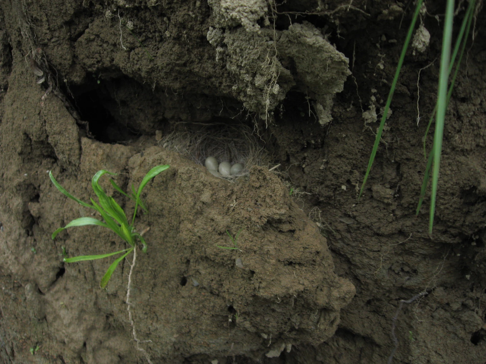
A small bird nest containing several speckled eggs, built into a hollowed-out muddy riverbank with green grasses nearby.
A bird nest with eggs tucked into the earthen bank of the Orke river.

Naturschutzgebiet Orketal history and protected-area timeline

Naturschutzgebiet Orketal was first formally designated as a protected area in 1999 by decree of the Bezirksregierung Arnsberg, the regional government authority then responsible for nature protection in this part of North Rhine-Westphalia. The decree established the statutory protection of the Orke brook, the surrounding floodplain meadows, and the adjoining valley landscapes that define the reserve.

In 2003, the reserve was reorganised through the landscape plan for Medebach produced by the Untere Landschaftsbehörde of the Hochsauerlandkreis. Under this updated plan the Orketal area was re-designated as a Naturschutzgebiet, reaffirming and refining its protection status in line with the evolving regional conservation framework. The 2003 re-designation also formally embedded the reserve in the county's wider protected-area system, placing it alongside neighbouring reserves such as Waldreservat Glindfeld, Hallebachtal, and the various Medebach meadow and slope reserves listed in the district inventory. The 2003 landscape plan, which devotes pages 25 to 31 and 74 to Orketal, remains the principal reference document for management and protection objectives.

Naturschutzgebiet Orketal landscape and geographic character

The landscape of Naturschutzgebiet Orketal is shaped by the Orke, a small Sauerland brook that has carved a relatively narrow, softly contoured valley between the town boundaries. The valley sides rise gently rather than dramatically, carrying a mix of coniferous forest, mixed woodland, and traditionally managed grassland. The valley floor follows the brook closely, with shallow banks, eroded edges, gravel beds, and the wider Aue floodplain stretching out beside the channel.

The defining visual character of the reserve is the contrast between the linear green corridor of the floodplain meadows along the Orke and the darker, forested slopes on either side. The valley is wide enough in places for open meadows dotted with wildflowers, and narrow enough elsewhere to feel enclosed by forest. The village of Medelon sits in the valley floor and breaks the reserve into two visually distinct sections. Toward the western end, the protected landscape merges almost seamlessly into the Glindfeld forest reserve, where the same valley pattern continues under a different protective designation. The eastern boundary near the Hessian state line marks a transition into the neighbouring landscape of Lichtenfels.

Naturschutzgebiet Orketal ecosystems, habitats, and plant life

Ecologically, the reserve preserves a representative slice of a Sauerland brook valley where flowing freshwater, soft floodplain meadows, wet flushes, and adjacent woodland coexist within a short distance. The Orke itself provides a continuous thread of fresh, oxygen-rich water, with shallow gravel reaches and undercut banks that create microhabitats for fish, dragonflies, and bank-nesting birds. The adjacent Aue holds both wet and mesotrophic grassland communities, where traditional low-intensity management has allowed meadow species typical of nutrient-poor sites to persist.

Vegetation in the reserve reflects this habitat mosaic. The documented plant list includes typical floodplain and wet-meadow species such as bittercress, brook water-cress, water forget-me-not, marsh marigold, marsh woundwort, common valerian, meadow lady's mantle, several bedstraws and stitchworts, yellow flag iris, yellow water-lily, common butterbur, and various Carex and fern species associated with moist shaded valley forest. Heathland and dry-grassland indicators such as bell heather, broom, and autumn crocus occur on drier slopes. The presence of Trollblume (globeflower), Devil's-bit scabious, and several orchids points to remnant high-quality semi-natural grassland, while species like common broom and heather hint at the transition to drier hillside heath characteristic of the Rothaargebirge periphery.

Naturschutzgebiet Orketal wildlife and species highlights

The wildlife character of Naturschutzgebiet Orketal is dominated by species adapted to clean, slow-flowing brooks and adjacent floodplain meadows. The brook supports native brown trout (Bachforelle) and the surroundings hold breeding populations of grey wagtail (Gebirgsstelze) and European kingfisher (Eisvogel), both classic indicator species for healthy lowland brook habitats in central Europe. Kingfishers in particular require stable banks and clear water for nesting, so their documented presence here is itself an indicator of habitat quality.

A wide range of other breeding birds has been recorded, including white wagtail, whinchat, marsh warbler, garden warbler, blackcap, wood warbler, tree creeper, willow tit, blue tit, great tit, robin, wren, common chiffchaff, redstart, goldfinch, yellowhammer, spotted flycatcher, and red-backed shrike (Neuntöter), together with mallard as a typical waterfowl on the brook. The reserve also supports diverse dragonfly and damselfly communities, such as the blaugrüne Mosaikjungfer, the blaugrüne Prachtlibelle, and the willow emerald, which depend on slow-moving reaches and wet meadow margins. Among reptiles, the grass snake (Ringelnatter) is documented, completing a typical lowland-brook faunal assemblage. Numerous grasshoppers documented in the area, including the meadow grasshopper, field grasshopper, and Roesel's bush-cricket, confirm the presence of structured, undisturbed meadow vegetation.

Naturschutzgebiet Orketal conservation status and protection priorities

The principal conservation value of Naturschutzgebiet Orketal lies in maintaining an ecologically functional brook valley in a region where land use has historically been dominated by forestry, agriculture, and small-scale settlement. The reserve formally protects the Orke brook itself, its floodplain meadows, and the broader habitat mosaic from more intensive forms of land use. The Schutzzweck states that the area has been declared a nature reserve on the grounds of its rarity, special character, and natural beauty, a phrasing typical of German NSG protection orders.

Beyond its national designation, the reserve contributes to two European-level conservation instruments. It lies within the EU Birds Directive site Medebacher Bucht (DE-4717-401), which protects important populations of bird species across a much larger landscape, and it overlaps with the FFH site Waldreservat Glindfeld-Orketal under the EU Habitats Directive. This nesting of local, regional, and European protections gives the reserve an outsized role in maintaining habitat continuity for brook species, floodplain meadow communities, and the forest habitats that together define the Orke valley. The recurring presence of sensitive indicator species such as kingfisher, grey wagtail, and brown trout underpins the broader claim that the valley remains ecologically intact.

Top sights and standout views in Naturschutzgebiet Orketal

Naturschutzgebiet Orketal offers a focused view of a traditional Sauerland brook valley and is best appreciated as a quiet, walkable landscape of small scale and high habitat integrity. Its strongest points of interest are the protected stretch of the Orke and its Aue floodplain meadows, the presence of breeding kingfishers and grey wagtails along the brook, and the unusually rich plant inventory documented by the state environment agency. The reserve also stands out for its integration into the Medebacher Bucht bird protection area and the Glindfeld-Orketal FFH site, and for the seamless way it links with the neighbouring forest reserve to the west, creating a near-continuous protected valley on the northern edge of Medebach.


Monthly climate preview

Long-term temperature ranges and precipitation averages recorded at a representative elevation point

Naturschutzgebiet Orketal Climate Normals and Monthly Weather Patterns

Recorded measurements from 1991 to 2020 establish the baseline temperature and precipitation rhythm across twelve distinct periods at a representative coordinate. Reviewing the complete monthly profile provides deeper analytical context for long-term climatological conditions across the protected terrain.
Annual mean8 °C
-1 °C18 °C
Jan-1°
Feb
Mar
Apr
May12°
Jun15°
Jul18°
Aug17°
Sep13°
Oct
Nov
Dec
Warmest month
July

17.6 °C

Coolest month
January

-1 °C

Wettest month
July

2.6 mm/day

Driest month
April

1.7 mm/day

Park location guide

Geography guide, regional context, and park location map for Naturschutzgebiet Orketal

Naturschutzgebiet Orketal park geography, regions, and map view in Germany

Understand where Naturschutzgebiet Orketal sits in Germany through a broader geographic reading of the surrounding landscape, nearby location context, and its mapped position within the national park landscape.

How Naturschutzgebiet Orketal fits into Germany

Germany is a federal republic in Western and Central Europe with a population of over 83 million across sixteen constituent states. It is Europe's largest economy by nominal GDP and a major global exporter and importer. The capital is Berlin, and the country borders Denmark, Poland, Czech Republic, Austria, Switzerland, France, Luxembourg, Belgium, and the Netherlands.

Wider geography shaping Naturschutzgebiet Orketal in Germany

Germany is located in Western and Central Europe, spanning 357,022 km². It borders Denmark to the north, Poland and the Czech Republic to the east, Austria and Switzerland to the south, and France, Luxembourg, Belgium, and the Netherlands to the west. The country has coastlines on the Baltic Sea and North Sea to the north, with the Alps located in the southern region.

Map view of Naturschutzgebiet Orketal

Use this park location map to pinpoint Naturschutzgebiet Orketal in Germany, understand its exact geographic position, and read its mapped placement within the surrounding landscape more clearly.

Pigeon | © OpenStreetMap contributors

Location context for Naturschutzgebiet Orketal

North Rhine-Westphalia

Visual reference collection highlighting brook habitats, floodplain meadows, and forest terrain.

Naturschutzgebiet Orketal Landscape Photos and Protected Valley Scenery

Visual documentation captures the intact valley corridor, meandering brook channels, and wildflower meadows defining Naturschutzgebiet Orketal. Studying field photography reveals habitat mosaics, forest edges, and protected Sauerland topography.

A small bird nest containing several speckled eggs, built into a hollowed-out muddy riverbank with green grasses nearby.

A wide view of a green meadow in the Orketal valley with a line of trees in the background and several sheep grazing in the distance.

Park atlas

Compare adjacent brook valleys, forest reserves, and connected conservation landscapes in the surrounding region.

Other Parks Near Naturschutzgebiet Orketal And Regional Protected Areas

Browsing other parks near Naturschutzgebiet Orketal reveals broader ecological patterns across the Sauerland uplands and nearby river corridors. Comparing these protected landscapes highlights connected habitats, regional river valleys, and shared conservation networks throughout central Germany.
A watercolor painting showing a soft, green, rolling valley with a stream and yellow wildflowers in the foreground against a light, distant hilly horizon.
Nature reserveNorth Rhine-Westphalia
About 4.4 km away#1 closest

Southwest

Naturschutzgebiet Ölfetal: Mapped Boundaries and Grassland Ecosystems in the Sauerland

A regional protected nature reserve near Medebach

Naturschutzgebiet Ölfetal offers a detailed look into the meadow-and-stream ecology of the Sauerland uplands. Stretching along the Ölfe river, the reserve features a complex mosaic of wet and dry meadow habitats that support specific plant species and local grassland bird populations. Its protected status maintains a vital stream corridor that bridges agricultural zones and broader ecological networks within eastern North Rhine-Westphalia.

Area
0.124 km²
Established
2003
Relief
Lowland
Scope
Terrestrial
Nature reserveHochsauerlandkreis
About 8.5 km away#2 closest

Northwest

Naturschutzgebiet Almecke: Geographic Atlas and Protected Landscape Overview

A preserved hedgerow mosaic in the Hochsauerlandkreis region.

Naturschutzgebiet Almecke is a significant nature reserve characterized by its formal inclusion in the European bird protection area network. The site offers a concentrated look at traditional cultural landscapes, specifically the interaction between steep valley topography, contour-following hedgerows, and dry upland pastures. This protected area serves as an essential case study in localized conservation geography and habitat structure within the wider Sauerland region.

Area
0.058 km²
Established
2003
Relief
Upland
Scope
Terrestrial
Nature reserveNorth Rhine-Westphalia
About 8.7 km away#3 closest

Northwest

Naturschutzgebiet Oberes Dittelsbachtal - Klokenbruch: Regional Protected Area Map

Sauerland brook valley and meadow landscape

This nature reserve protects 14 hectares of the upper Dittelsbach stream and surrounding damp grasslands. The landscape is defined by its compact valley form, spring-fed mires, and traditional grazing patches, serving as an important link for bird protection in the Medebacher Bucht region of North Rhine-Westphalia.

Area
0.139 km²
Established
2003
Scope
Terrestrial
Water
Major water bodies
Nature reserveHochsauerlandkreis
About 10 km away#4 closest

North

Naturschutzgebiet Osterntal: Protected Valley Mosaic and Regional Geography

Explore nature reserve boundaries and ecological terrain in Hochsauerlandkreis.

Naturschutzgebiet Osterntal protects a distinct valley mosaic in the eastern Sauerland, featuring rare wet grasslands and nutrient-poor meadows. This nature reserve provides essential habitat connectivity within the broader European Bird Protection Area, showcasing the region's managed pastoral landscape and varied topography.

Area
0.064 km²
Established
2003
Relief
Upland
Climate
Temperate
A soft watercolor painting depicting a landscape of rolling green hills, gentle slopes, and distant mountains against a plain background.
Nature reserveHessen
About 11 km away#5 closest

North

Naturschutzgebiet Kahle Pön bei Usseln: Protected Highland Heath and Upland Landscapes

A rare botanical nature reserve within the Hessian Upland landscape

Naturschutzgebiet Kahle Pön bei Usseln protects an open heath plateau above the Usseln valley, providing essential habitat for heath-breeding birds and rare butterflies. This nature reserve serves as an vital component of the transboundary highland heath network, demonstrating unique conservation efforts through sheep grazing and sod removal on former beech woodland soils in Waldeck-Frankenberg.

Area
0.35 km²
Established
1987
IUCN
IV
A pale, minimalist watercolor painting showing rolling green hills, meadows, and sparse trees against a soft, light background.
Nature reserveWaldeck-Frankenberg
About 11 km away#6 closest

North

Naturschutzgebiet Grotenberg bei Welleringhausen: Mapped Nature Reserve in Waldeck-Frankenberg

A preserved dry grassland landscape in the eastern Sauerland mountains.

This protected area represents a crucial remnant of silicate dry grassland in the Waldeck-Frankenberg district. Known for its diabase-rich volcanic substrate and successful habitat restoration through traditional Heidschnucken sheep grazing, the reserve offers a compact window into the upland ecology of the eastern Sauerland mountain region.

Area
0.198 km²
Established
1992
IUCN
IV
A horizontal watercolor painting depicting a soft green landscape with rolling hills, a meandering stream, and light vegetation.
Nature reserveNordrhein-Westfalen
About 11 km away#7 closest

West

Naturschutzgebiet Schluchtwald Helle: Ravine Forest Geography and Protected Area Overview

Mapping the Sauerland upland streams and old-growth woodland habitat

This protected nature reserve spans roughly 58 hectares of steep, incised terrain near Winterberg, Germany. It safeguards the headwaters of the Helle stream, providing a stable, humid microclimate that fosters high biodiversity within a compact, moss-covered woodland setting that remains free from active human management.

Area
0.581 km²
Established
2008
IUCN
IV
Relief
Upland
Nature reserveWaldeck-Frankenberg
About 11 km away#8 closest

Northwest

Naturschutzgebiet Jägers Weinberg: Geographic Profile of a Protected Upland Wetland

A mapped nature reserve in the Waldeck-Frankenberg district of northern Hesse

Naturschutzgebiet Jägers Weinberg is a protected wetland landscape in northern Hesse, Germany. This area preserves a rare combination of raised bog and birch swamp forest, functioning as a vital botanical refuge in the Waldeck-Frankenberg district. Its mapped boundaries highlight a specialized ecological site that offers clear insights into the micro-topography and natural history of the local Upland terrain.

Area
0.254 km²
Established
1979
IUCN
IV
Relief
Upland

Common questions about visiting, size, designation, and location context for Naturschutzgebiet Orketal

Naturschutzgebiet Orketal FAQs for park facts, access, geography, and protected area context

Find quick answers about Naturschutzgebiet Orketal, including protected-area facts, park geography, trail and visitor context, and how the park fits into its surrounding country and regional landscape.
MoriAtlas Explorer

Continue Your Protected Areas Search Across the Global Atlas

Deepen your exploration by continuing the structured search for national parks and protected areas worldwide. Utilize the comprehensive filtering capabilities to compare different conservation landscapes and refine your understanding of global park geography. Discover more about the distribution and characteristics of protected natural areas.

Global natural geography