
Mori Atlas logo
Nature reserveNaturschutzgebiet Piepenbruch

A vital spring-fed grassland refuge within the traditional Sauerland agricultural mosaic

Naturschutzgebiet Piepenbruch: Examining the Protected Wet Meadow Landscapes of Hochsauerlandkreis

Naturschutzgebiet Piepenbruch represents a critical conservation effort to preserve moisture-loving grassland habitats in the Hochsauerlandkreis region. Located along an east-facing valley slope near Langscheid, this protected nature reserve serves as an ecologically significant stepping-stone for birdlife and marsh flora. By maintaining traditional grazing regimes on these saturated slopes, the reserve protects a rare fragment of the historic landscape once characteristic of German upland valleys.

wet meadownature reserveSauerlandNorth Rhine-Westphaliastepping-stone habitatspring-fed grassland
A flat-style digital illustration depicting a wide, verdant green valley featuring a waterfall cascading from tall rocky cliffs into a winding stream, with small houses situated in the lower foreground and forested hills in the distance.

Naturschutzgebiet Piepenbruch

Nature reserve

Park overview

Structured park overview, official facts, and landscape profile for Naturschutzgebiet Piepenbruch

Naturschutzgebiet Piepenbruch park facts, protected area profile, and essential visitor context

Review the core facts for Naturschutzgebiet Piepenbruch, including designation, size, terrain, visitor scale, habitats, and operating context in one park-focused overview.

About Naturschutzgebiet Piepenbruch

Naturschutzgebiet Piepenbruch is a very compact but ecologically focused nature reserve in the Sauerland region of western Germany. Its subject is not a dramatic landscape feature, but a particular type of habitat: small, waterlogged patches of agricultural grassland that have been kept open through grazing for generations. By formally protecting such a small slice of land, the reserve aims to lock in a tradition of low-intensity land use that is rapidly disappearing across central German uplands.

The reserve sits on the east-facing slope of a small side valley belonging to the Flasmecke, a stream that flows through the local landscape protection area of the same name. The ground is permanently damp because groundwater emerges along the slope and keeps the soil saturated. This combination of slope orientation, shallow groundwater, and grazing has produced a patchwork of rush-dominated wet meadows intermingled with slightly drier pasture.

Designated in 2019 as part of the new Landscape Plan Sundern, the reserve belongs to a wave of small, targeted designations that complement larger landscape protection areas in the Hochsauerlandkreis. Piepenbruch does not seek to attract large numbers of visitors; instead, it functions as a refuge patch that supports characteristic plants and birds of wet grassland, while conservation is achieved through continued grazing under the county's cultural landscape programme.

Quick facts and research context for Naturschutzgebiet Piepenbruch

Naturschutzgebiet Piepenbruch is a nature reserve in North Rhine-Westphalia, Germany, located east of Langscheid in the town of Sundern within the Hochsauerlandkreis. The site covers about 2.3 hectares of spring-fed, rush-rich wet pasture on a valley slope above the Flasmecke stream.

It was designated as a nature reserve in 2019 through the revised Landscape Plan Sundern, having previously been unscheduled land under the 1993 plan. The reserve is enclosed by the Flasmecketal Landscape Protection Area and forms part of a broader network of protected sites in the Sauerland.

Protection and recognition

Terrestrial conservation management scope and official protected area records

Naturschutzgebiet Piepenbruch Protection Status and Recognition Data

Naturschutzgebiet Piepenbruch maintains documented terrestrial protection metrics within the global database. Verified administrative records outline the official conservation status and management scope for this protected landscape.

Protection details

Protection scope
Terrestrial
Transboundary protection
No
WDPA ID
555737235
Park context

Deeper park guide and search-rich context for Naturschutzgebiet Piepenbruch

Naturschutzgebiet Piepenbruch history, landscape, wildlife, and travel context

Explore Naturschutzgebiet Piepenbruch through its history, landscape character, ecosystems, wildlife, conservation priorities, cultural context, and seasonal travel timing in a structured park guide built for atlas discovery and search intent.

Why Naturschutzgebiet Piepenbruch stands out

Piepenbruch is best known as a protected example of a historically widespread but now scarce habitat: permanently moist, spring-influenced pasture on a low mountain valley slope. The reserve combines small-scale wet grassland, characteristic rush vegetation, and a traditional grazing regime, making it a textbook case of a Sauerland wet meadow fragment.
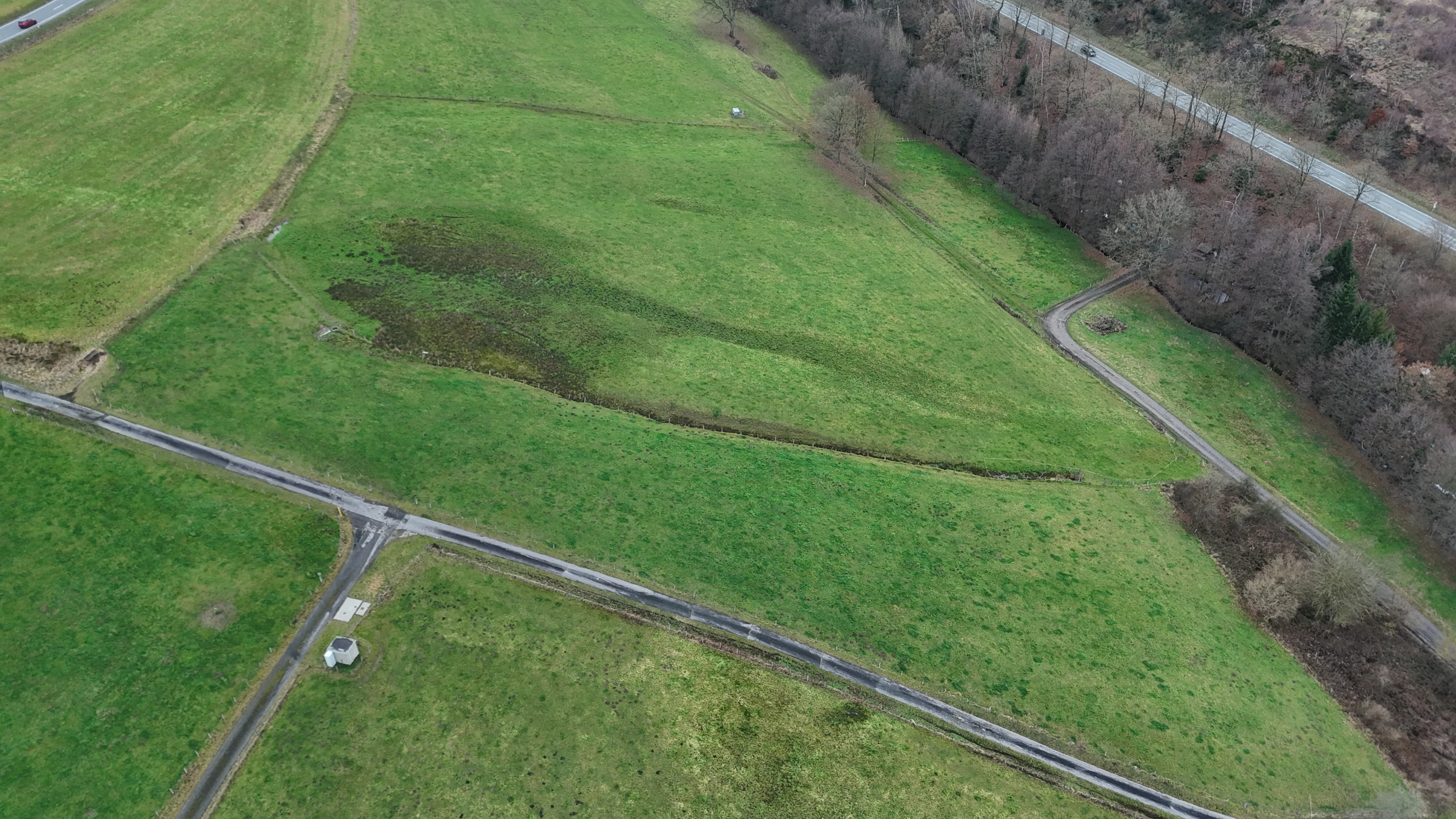
An aerial view of a green meadow in the Piepenbruch nature reserve, with narrow trails and a small water channel cutting through the grass.
Aerial view of the Piepenbruch nature reserve showing wet grassland habitats.

Naturschutzgebiet Piepenbruch history and protected-area timeline

The area that is now Naturschutzgebiet Piepenbruch had no formal conservation status under the original Landscape Plan Sundern of 1993. For more than two decades afterwards the wet meadows at the head of the Flasmecke side valley were simply part of the ordinary countryside, despite their ecological interest.

Protection came in 2019, when the Hochsauerlandkreis adopted a fully revised Landscape Plan Sundern. As part of this new plan, the county council designated Piepenbruch as a nature reserve, embedding the small wet pasture site within the wider Flasmecketal Landscape Protection Area. The designation was tied explicitly to a continuing grazing regime, intended to keep the characteristic rush-rich grassland intact.

Naturschutzgebiet Piepenbruch landscape and geographic character

The landscape of Piepenbruch is a typical Sauerland minor valley setting, defined less by dramatic relief than by subtle gradients of moisture. The reserve lies on the east-exposed slope that drops down toward the Flasmecke stream, a small watercourse that winds through a wider wooded and pastoral valley to the north.

Topography is shaped by gently sloping fields rather than steep crags. The defining landscape feature is not elevation but the presence of springs along the slope, which keep parts of the pasture permanently soft and saturated. As a result, the terrain divides into wet, occasionally almost boggy depressions and slightly firmer, somewhat drier pasture strips, separated by no clear boundary.

Around the reserve proper, the Flasmecketal landscape protection area extends the same gently sloping countryside further along the valley, mixing pasture, hedgerow, woodland edge, and occasional stream-side vegetation to create a quiet mid-mountain mosaic typical of the southern Hochsauerlandkreis.

Naturschutzgebiet Piepenbruch ecosystems, habitats, and plant life

Ecologically, Piepenbruch belongs to the group of spring-fed wet meadows that were once widespread across the German Mittelgebirge but have shrunk dramatically with modern agricultural drainage and intensification. The reserve functions as a small but representative fragment of that formerly common habitat type.

Two wet pasture areas form the core of the site. Both are kept moist by springs and seepage lines that emerge along the valley slope. The vegetation is dominated by soft rush species, with characteristic spring starwort mixed in, alongside plants more typical of marsh marigold meadows. The resulting mosaic supports a noticeably richer flora than the surrounding improved grassland.

Because the site lies within a much larger landscape protection area, its ecological value extends beyond its two hectares. The combination of protected wet meadow, surrounding grazed slopes, hedgerows, and nearby stream-side vegetation creates a coherent ecological gradient that supports both wetland plants and the insects and birds associated with them.

Naturschutzgebiet Piepenbruch wildlife and species highlights

The reserve is recognised as habitat for bird species associated with open wet grassland, although the tiny size of the protected area means its role is primarily as a refuge and stepping stone rather than a self-contained bird territory. Within the broader Sauerland farming landscape, the wet meadows of Piepenbruch and similar sites provide nesting and feeding habitat that has become harder to find on intensively improved pasture.

The plant communities also support a range of invertebrates typical of damp, traditionally managed grassland, including pollinators associated with marsh marigold and rush flowers. While the available source material does not provide a detailed species list, the landscape plan explicitly identifies the area as significant for rare plant and bird species, and highlights its function as a refuge patch in a heavily used agricultural environment.

Naturschutzgebiet Piepenbruch conservation status and protection priorities

From a conservation standpoint, Piepenbruch matters because it protects a habitat that has become rare nationwide: traditionally grazed, spring-fed wet pasture on a low mountain slope. The Landscape Plan Sundern describes such wet pastures as a formerly widespread grassland type that is now comparatively uncommon and therefore especially worthy of preservation.

The formal protection goal is twofold. The reserve is intended to safeguard, maintain, and develop wet grassland and its associated plant and animal communities as a stepping-stone and refuge habitat within a heavily used agricultural region. It also serves to secure, on a long-term basis, particularly worthy habitats protected under section 30 of the Federal Nature Conservation Act and the populations of rare plant and animal species associated with them.

Management is deliberately simple and traditional. The obliging requirement attached to the designation is that the grassland must continue to be grazed, preferably following the grazing protocols of the Hochsauerlandkreis cultural landscape programme. This preserves the low-intensity land use on which the habitat depends and ensures the conservation value of the site is maintained through ongoing farming practice rather than abandonment.

Naturschutzgebiet Piepenbruch cultural meaning and human context

Piepenbruch reflects the long-standing pastoral land use that has shaped the Sauerland for centuries. The reserve is not a wilderness; it is operated farmland whose traditional grazing pattern is the very reason it has ecological value. By tying the nature reserve status directly to continued grazing under the county's cultural landscape programme, the designation explicitly recognises that the cultural practice of low-intensity mountain pasture is part of what needs to be preserved.

The site also fits into a broader pattern of small, habitat-focused reserves in the Hochsauerlandkreis, where individual fragments of meadow, woodland, and stream valley are protected within a larger matrix of working countryside and landscape protection areas.

Top sights and standout views in Naturschutzgebiet Piepenbruch

Piepenbruch is a textbook example of a very small, very specific nature reserve whose value lies in what it represents rather than in sheer size. Its highlights include:

Echo of a lost habitat type: the reserve protects a fragment of spring-fed wet pasture that was once commonplace in the German Mittelgebirge and is now scarce.

Close integration of culture and ecology: protection only works because grazing continues, linking conservation directly to traditional mountain farming.

Strong landscape context: the reserve sits within the larger Flasmecketal Landscape Protection Area, giving the small site a buffer of less intensively used countryside.

Recognised stepping-stone value: the site is explicitly identified as a refuge and stepping-stone habitat in an intensively farmed region.

Recent designation: protection only began in 2019, making the reserve a relatively young but clearly defined addition to the network of Sauerland nature reserves.

Best time to visit Naturschutzgebiet Piepenbruch

Because Piepenbruch is a tiny wet meadow reserve rather than an attraction with developed visitor infrastructure, the practical value of seasonal timing lies in matching conditions for quiet nature observation.

Late spring and early summer are likely to be the most rewarding periods for visiting the area more broadly. This is when marsh marigolds, ragged robin, and rush flowers are at their peak in wet meadows of this type, and associated insects and birds are most active. Late summer and early autumn tend to be a quieter period with grasses and rushes in seed, offering a different but still pleasant character.

Wet soils are a defining feature of the site at any time of year, so visitors should expect damp ground, especially after rain. Winter is generally not recommended for viewing but illustrates the importance of preserving the habitat year-round.


Monthly climate preview

Long-term representative point measurements for temperature and precipitation by month

Naturschutzgebiet Piepenbruch Climate Normals and Annual Temperature Rhythm

Representative coordinate records for Naturschutzgebiet Piepenbruch outline a measured annual temperature range from sub-zero winter minimums to warm summer maximums alongside steady daily precipitation averages. Detailed monthly breakdowns provide complete baseline climate profiles for analytical comparison across the entire protected area.
Annual mean9 °C
0 °C18 °C
Jan
Feb
Mar
Apr
May12°
Jun16°
Jul18°
Aug18°
Sep14°
Oct
Nov
Dec
Warmest month
July

18.2 °C

Coolest month
January

0.3 °C

Wettest month
December

2.7 mm/day

Driest month
April

1.7 mm/day

Park location guide

Geography guide, regional context, and park location map for Naturschutzgebiet Piepenbruch

Naturschutzgebiet Piepenbruch park geography, regions, and map view in Germany

Understand where Naturschutzgebiet Piepenbruch sits in Germany through a broader geographic reading of the surrounding landscape, nearby location context, and its mapped position within the national park landscape.

How Naturschutzgebiet Piepenbruch fits into Germany

Germany is a federal republic in Western and Central Europe with a population of over 83 million across sixteen constituent states. It is Europe's largest economy by nominal GDP and a major global exporter and importer. The capital is Berlin, and the country borders Denmark, Poland, Czech Republic, Austria, Switzerland, France, Luxembourg, Belgium, and the Netherlands.

Wider geography shaping Naturschutzgebiet Piepenbruch in Germany

Germany is located in Western and Central Europe, spanning 357,022 km². It borders Denmark to the north, Poland and the Czech Republic to the east, Austria and Switzerland to the south, and France, Luxembourg, Belgium, and the Netherlands to the west. The country has coastlines on the Baltic Sea and North Sea to the north, with the Alps located in the southern region.

Map view of Naturschutzgebiet Piepenbruch

Use this park location map to pinpoint Naturschutzgebiet Piepenbruch in Germany, understand its exact geographic position, and read its mapped placement within the surrounding landscape more clearly.

Pigeon | © OpenStreetMap contributors

Location context for Naturschutzgebiet Piepenbruch

HochsauerlandkreisNordrhein-Westfalen

Visualizing the wet meadow habitats and protected Sauerland valley terrain

Naturschutzgebiet Piepenbruch Photos and Landscape Scenery

Visual records reveal the spring-fed moisture gradients and low-intensity pasture zones defining Naturschutzgebiet Piepenbruch. Examining these field photographs clarifies the unique vegetation patterns and protected landscape character preserved across the valley slope.

An aerial view of a green meadow in the Piepenbruch nature reserve, with narrow trails and a small water channel cutting through the grass.

An aerial view of green rolling hills and meadows in Germany, with small residential clusters and forest edges visible.

Park atlas

Compare regional upland landscapes and surrounding nature reserves

Explore Protected Areas and Parks Near Naturschutzgebiet Piepenbruch

Browsing parks near Naturschutzgebiet Piepenbruch reveals a broader network of protected Sauerland valleys, damp pastures, and low-mountain habitats. Extending the geographic comparison helps connect individual nature reserves with the wider regional conservation landscape.
A soft watercolor illustration depicting rolling green hills, dense forest patches, and a winding stream flowing through a grassy meadow.
Protected landscapeGermany
About 3.7 km away#1 closest

North

Luerwald und Bieberbach Protected Landscape: Regional Forest Map and Habitat Overview

A major continuous woodland reserve in North Rhine-Westphalia, Germany.

Spanning the landscape between Neheim and Menden, Luerwald und Bieberbach functions as a critical Special Protection Area. The terrain features extensive beech and oak woodlands intersected by the Bieberbach stream, creating an important haven for woodland species and maintaining a large, undisturbed environmental mosaic across the northern Sauerland.

Nature reserveHochsauerlandkreis
About 4.5 km away#2 closest

East

Naturschutzgebiet Oberes Walpketal: Protected Nature Reserve and Valley Geography

Brook valley habitat in the Hochsauerlandkreis region of Germany.

Located in the Sundern area, Naturschutzgebiet Oberes Walpketal encompasses a 5.6-hectare valley corridor shaped by the upper Walpke stream. The site serves as a vital protected area, showcasing the ecological transition from moist alder riparian forests to upland beech stands typical of the Sauerland landscape. This record outlines the reserve's topography, stream-side composition, and its function as a stepping-stone biotope.

Area
0.056 km²
Established
2019
Relief
Upland
Climate
Temperate
A soft watercolor painting of a green, rolling valley with a stream winding through the grassy foreground against a background of distant, misty hills.
Nature reserveNordrhein-Westfalen
About 4.9 km away#3 closest

West

Naturschutzgebiet Orlebachtal Protected Stream Valley and Floodplain Geography

A preserved meandering valley in the Sauerland foothills

This nature reserve protects a small but geomorphically active stream valley featuring a clean, oxygen-rich brook and diverse floodplain meadows. Managed through traditional grazing to sustain rare grassland species, the valley provides a representative look at the terrain and riparian ecology of the North Rhine-Westphalia region.

Area
0.151 km²
Established
1989
Relief
Upland
Scope
Terrestrial
Nature reserveNorth Rhine-Westphalia
About 6 km away#4 closest

Southeast

Naturschutzgebiet Schla Nature Reserve: Geographic Profile and Protected Forest Landscape

Limestone hilltop woodland in North Rhine-Westphalia

Naturschutzgebiet Schla serves as a representative example of calcareous oak-hornbeam forests in the Hochsauerlandkreis. This small, 3.4-hectare nature reserve preserves ancient, 200-year-old oaks and a specialized geophyte-rich herb layer. Its hilltop position, characterized by thin limestone soils and proximity to an abandoned quarry, creates a unique microclimate that supports forest biodiversity and research into habitat connectivity in rural Germany.

Area
0.034 km²
Established
1993
Relief
Upland
Scope
Terrestrial
Nature reserveHochsauerlandkreis
About 6.1 km away#5 closest

Southeast

Naturschutzgebiet Schatthangwald Röhre Protected Nature Reserve in Hochsauerlandkreis

Geographic overview of limestone forests and karst cave systems

Spanning 5.6 hectares, Naturschutzgebiet Schatthangwald Röhre illustrates a dense concentration of calcareous habitats. The area features a complex intersection of beech forest, abandoned limestone quarry floors, and significant subterranean features within the Röhr river valley context.

Area
0.056 km²
Established
1993
Relief
Upland
Scope
Terrestrial
A watercolor illustration depicting a wide valley with green hills, white limestone rock formations, and a small reddish cave entrance.
Protected landscapeNordrhein-Westfalen
About 6.2 km away#6 closest

West

Hönnetal Protected Landscape: Mapping the Karst Valley and Limestone Cliffs of Nordrhein-Westfalen

A deep dive into the geology, conservation, and physical terrain of the Hönne river valley.

The Hönnetal stands as one of Central Europe's most striking karst landscapes, characterized by white limestone cliffs rising 60 meters above the riverbed. This protected area within Nordrhein-Westfalen represents a critical intersection of ancient geological processes, including dense cave networks and unique beech forests, alongside a historic civic conservation movement that preserves its defining natural boundaries.

Area
1.442 km²
Established
1920
Relief
Upland
Climate
Temperate
Nature reserveNorth Rhine-Westphalia
About 6.3 km away#7 closest

North

Naturschutzgebiet Schakenberg: Protected Beech Forest Landscape and Regional Geography

A rare calcareous woodland reserve in the Hachener Kuppenland

Naturschutzgebiet Schakenberg safeguards a near-natural Waldmeister-Buchenwald forest on a limestone hilltop. This protected area acts as a crucial ecological anchor within the Luerwald and Bieberbach Natura 2000 network, showcasing the distinct hilly topography and forest biodiversity characteristic of the eastern Sauerland.

Area
0.022 km²
Established
1998
Relief
Upland
Climate
Temperate
Nature reserveHochsauerlandkreis
About 6.4 km away#8 closest

East

Naturschutzgebiet Oberlauf des Hellefelder Baches: Protected Stream and Valley Geography

A forest-focused nature reserve in the Hochsauerlandkreis

Discover the geographic layout of Naturschutzgebiet Oberlauf des Hellefelder Baches, a nature reserve in the northern Sauerland. This protected area centers on the upper reaches of the Hellefelder Bach, preserving wooded ravines and critical headwater springs within a broader matrix of regional forest management.

Area
0.089 km²
Established
2019
Relief
Upland
Scope
Terrestrial

Common questions about visiting, size, designation, and location context for Naturschutzgebiet Piepenbruch

Naturschutzgebiet Piepenbruch FAQs for park facts, access, geography, and protected area context

Find quick answers about Naturschutzgebiet Piepenbruch, including protected-area facts, park geography, trail and visitor context, and how the park fits into its surrounding country and regional landscape.
MoriAtlas Explorer

Continue Your Protected Areas Search Across the Global Atlas

Deepen your exploration by continuing the structured search for national parks and protected areas worldwide. Utilize the comprehensive filtering capabilities to compare different conservation landscapes and refine your understanding of global park geography. Discover more about the distribution and characteristics of protected natural areas.

Global natural geography