Mori Atlas logo
Nature reserveNaturwald Kramer

Tracing the vertical gradient of forest zones across this significant Bavarian mountain protected area

Naturwald Kramer Nature Reserve: Mapped Protected Landscapes in the Ammergauer Alps of Bavaria

Naturwald Kramer encompasses an extensive mountain forest landscape within the Ammergauer Alps of Upper Bavaria, Germany. This protected area features a striking vertical elevation range, spanning from 755 meters to nearly 1950 meters, and serves as a vital reference site for natural forest dynamics. The terrain transitions from dense carbonate mountain mixed forests to rare snow heath pine woodlands, all supported by an intricate network of Loisach tributaries and dolomite bedrock formations.

natural forestAlpine forestmountain mixed forestsnow heath pine woodlandNatura 2000Ammergauer Alps

Naturwald Kramer

Nature reserve

Park overview

Structured park overview, official facts, and landscape profile for Naturwald Kramer

Naturwald Kramer park facts, protected area profile, and essential visitor context

Review the core facts for Naturwald Kramer, including designation, size, terrain, visitor scale, habitats, and operating context in one park-focused overview.

About Naturwald Kramer

Naturwald Kramer is a substantial protected forest area in the northern Ammergauer Alps, covering roughly 1590 hectares of terrain that spans almost 1200 meters of elevation. Designated in 2020 and managed by the Bayerische Staatsforsten (Bavarian State Forests), it represents one of the most ambitious outcomes of the Volksbegehren "Artenvielfalt and Naturschönheit in Bayern," a citizen initiative that pushed the Bavarian state government to set aside 10 percent of the state forest from active management.

The forest sits west of Garmisch-Partenkirchen and stretches toward the Austrian border, encompassing dramatic peaks such as the Kramerspitz and Hoher Ziegspitz. Its location within the FFH-Gebiet Ammergebirge and the overlapping bird Special Protection Area means that the protection status of Naturwald Kramer is reinforced at the European Natura 2000 level, securing both habitat and species protections.

Ecologically, the area is characterized by a classic Bavarian carbonate mountain mixed forest at lower elevations, transitioning upward into a distinctive Alpine-edge pine forest community. The site also contains the older Jakelberg Nature Forest Reserve, which has been set aside from forestry since 1989 and provides an important long-term reference for studying natural forest succession on dolomitic substrates in the Ammergauer Alps.

Quick facts and research context for Naturwald Kramer

Naturwald Kramer lies in the Ammergauer Alps within the district of Garmisch-Partenkirchen in Upper Bavaria. The protected forest was officially designated in 2020 by the Bavarian State Forest administration under Article 12a of the Bavarian Forest Act.

The site covers about 1590 hectares at elevations between roughly 755 meters and 1950 meters. It overlaps entirely with the Natura 2000 Habitats Directive site and the Special Protection Area known as Ammergebirge mit Kienberg und Schwarzenberg sowie Falkenstein.

Park context

Deeper park guide and search-rich context for Naturwald Kramer

Naturwald Kramer history, landscape, wildlife, and travel context

Explore Naturwald Kramer through its history, landscape character, ecosystems, wildlife, conservation priorities, cultural context, and seasonal travel timing in a structured park guide built for atlas discovery and search intent.

Why Naturwald Kramer stands out

Naturwald Kramer is best known for its unusually large, contiguous mountain mixed forest that has been permanently removed from timber management, allowing natural forest dynamics to unfold across an extensive altitudinal range. Within its boundaries lies the older Jakelberg Nature Forest Reserve, founded in 1989, where lower slopes host classic carbonate mountain mixed forests of spruce, fir, and beech, while sun-exposed, drier upper slopes transition into rare snow heath pine woodland (Schneeheide-Kiefernwald) on Hauptdolomite bedrock. The combination of geological variety, strong elevation contrast, and legal protection from forestry makes the area a reference site for natural forest development in the Bavarian Alps. Its setting at the northern edge of the Ammergebirge adds to its ecological value as a transitional zone between northern Alpine foothills and high alpine environments.
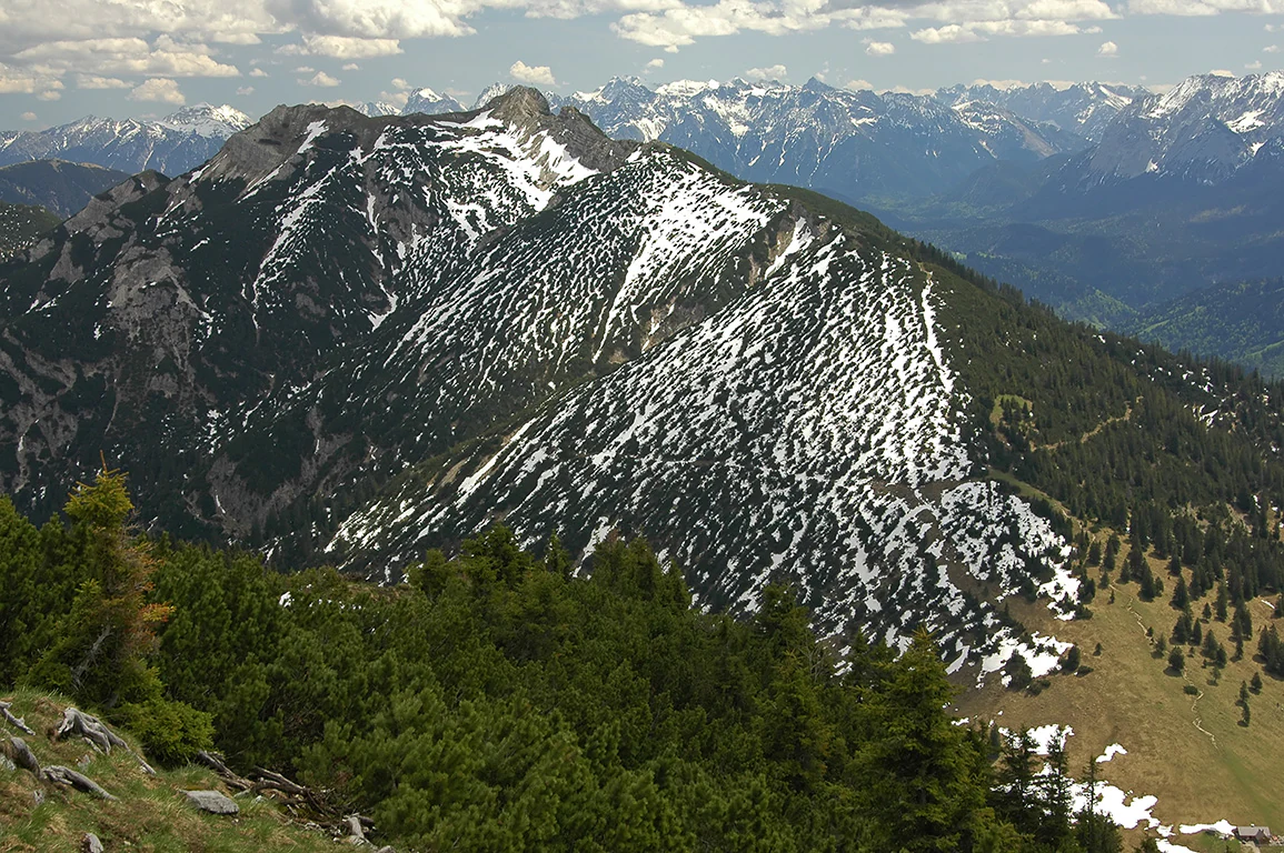
High altitude view of the rocky, snow-dusted Kramerspitz peak and surrounding forest in the Ammergau Alps.
Panoramic view of the Kramerspitz summit in the Ammergau Alps, featuring mountain mixed forest and partially snow-covered slopes.

Naturwald Kramer history and protected-area timeline

The origin of Naturwald Kramer as an officially designated area lies in the political and ecological momentum generated by the Volksbegehren "Artenvielfalt and Naturschönheit in Bayern," a successful citizen initiative that led the Bavarian state government to commit to taking 10 percent of state forest out of active use. In line with this commitment, parts of the area that had already been classified by the Bavarian State Forests as Klasse-1-Wald (forest withdrawn from regular use) were converted into a permanent natural forest.

The formal designation took place in 2020 under Article 12a of the Bavarian Forest Act, which governs Naturwaldreservate and Naturwaldflächen. Prior to this, the southern portion of the current protected forest had already been set aside in 1989 as the Jakelberg Nature Forest Reserve, covering about 110 hectares. The amalgamation of these historical protections into a single large Naturwald reflects a broader Bavarian and European trend of expanding strictly protected forest reserves.

Naturwald Kramer landscape and geographic character

The landscape of Naturwald Kramer is shaped by the rugged northern foothills and higher ridges of the Ammergauer Alps. Elevation spans from approximately 755 meters near Bundesstraße 23 in the south to almost 1950 meters near the summit of the Kramer itself, producing a sharp vertical gradient over a relatively compact area.

Notable summits within the protected forest include the Grießberg at 1636 meters, Rauhenstein at 1728 meters, Vorderer Ziegspitz at 1815 meters, Hoher Ziegspitz at 1864 meters, and the Kramerspitz at 1985 meters. The underlying bedrock is dominated by Hauptdolomit (Main Dolomite), which contributes to the relatively dry, carbonate-rich soils typical of the region.

A network of streams, including the Loisach tributaries Beistallaine, Zieggraben, Kammerlaine, Dürerlaine, Kögerlaine, and Ackerlaine, cuts through the valleys and contributes to the diversity of slopes and microhabitats. The result is a mosaic of forested slopes, rocky outcrops, and gentler valley terrain that defines the visual character of the Ammergauer Alps at this latitude.

Naturwald Kramer ecosystems, habitats, and plant life

Ecologically, Naturwald Kramer is defined by its forest communities, which change markedly with elevation and exposure. On the cooler and moister lower and middle slopes, the forest is dominated by a typical carbonate mountain mixed forest (Carbonat-Bergmischwald) composed of spruce, fir, and beech, with the species mix shifting gradually as conditions change.

At higher altitudes, where solar exposure is stronger and the sites become drier, spruce and fir gradually give way to Scots pine, forming the characteristic Carbonat-Kiefernwald am Alpenrand (Calamagrostio variae-Pinetum). This distinct pine woodland is a sub-group of the snow heath pine forest (Schneeheide-Kiefernwald) listed as a protected habitat type under the Habitats Directive.

The combination of dolomitic soils, steep slopes, valley streams, and forest refugia creates a complex mosaic of microhabitats. Because the forest is no longer subject to timber harvesting, natural processes such as windthrow, bark beetle dynamics, and natural regeneration are now actively expressed, increasing the structural diversity of habitats over time.

Naturwald Kramer wildlife and species highlights

Although the source material for Naturwald Kramer emphasizes vegetation and forest type more than fauna, the overlap of the protected forest with the Special Protection Area Ammergebirge mit Kienberg und Schwarzenberg sowie Falkenstein indicates that the area supports a rich birdlife typical of the Bavarian Alps. Forested montane slopes, mixed woodland, and cliff habitats provide breeding and foraging grounds for species associated with Alpine forests and rocky terrain.

The structural complexity of an unmanaged, naturally developing forest, with standing deadwood, fallen logs, and varying age classes, generally benefits a wide range of forest-dependent fauna, including saproxylic insects and cavity-nesting birds. The broader Ammergebirge context, which hosts raptors and other sensitive Alpine species, suggests that Naturwald Kramer contributes meaningfully to the regional network of habitats for these species.

Naturwald Kramer conservation status and protection priorities

The conservation significance of Naturwald Kramer lies in its large size, its strict protection from forestry, and its embedding within multiple layers of national and European protection. It is classified as an IUCN Category IV area (Habitat/Species Management Area), although in practice, the absence of active timber extraction means it functions as a strictly protected reference forest.

The area lies within the FFH-Gebiet Ammergebirge and within the larger Special Protection Area for birds, ensuring that it benefits from the protections of the EU Habitats and Birds Directives. The legally protected status of the snow heath pine woodland community under Section 30 of the Federal Nature Conservation Act adds a further layer of habitat-specific protection.

The site's designation in 2020 was a direct outcome of the Volksbegehren "Artenvielfalt and Naturschönheit in Bayern," illustrating the role of public policy in expanding the network of protected forests in Bavaria. As a permanently set-aside Naturwald, it serves as a reference area for natural forest development, supporting long-term monitoring, research, and biodiversity protection in the Ammergauer Alps.

Naturwald Kramer cultural meaning and human context

Naturwald Kramer is located in a region with deep cultural ties to Alpine traditions. The forest surrounds the market town of Garmisch-Partenkirchen, an area historically known for its mountain communities, pastoral land use, and Alpine tourism. Surrounding settlements such as Farchant, Grainau, Burgrain, and Griesen reflect the dispersed settlement patterns typical of the Bavarian Alps.

The forest itself is a product of modern conservation culture in Bavaria, shaped less by traditional land-use practices and more by recent public engagement with biodiversity through citizen-led initiatives. Its name derives from the Kramer, the prominent peak at the heart of the protected area, which has long served as a local landmark for communities in the Loisach valley.

Top sights and standout views in Naturwald Kramer

Naturwald Kramer stands out as one of Bavaria's largest Naturwaldflächen, combining a strict no-harvest regime with dramatic Alpine topography. The dramatic elevation range and the diversity of forest types, ranging from classic mountain mixed forest to rare snow heath pine woodland on dolomite, make it an important reference site for natural forest dynamics in the Ammergauer Alps.

Best time to visit Naturwald Kramer

The forest can be appreciated across the seasons as a quiet mountain landscape. Late spring and early summer offer fresh green foliage and active birdlife in the mixed forests at lower elevations, while summer is convenient for exploring higher slopes where the pine woodlands are most visible. Autumn brings strong colors in the deciduous components of the mountain mixed forest, and winter adds a quiet, snowy atmosphere that emphasizes the dramatic relief of the Kramerspitz and surrounding peaks. Because the area is managed primarily as a natural forest reserve, visitors generally experience it as a tranquil, low-intervention mountain environment year-round.

Monthly climate preview

Measured annual temperature and monthly precipitation patterns across representative coordinates

Naturwald Kramer Climate Normals and Long-Term Weather by Month

Representative coordinate records show measured average temperatures ranging from sub-zero winter minimums to warm summer maximums alongside varying monthly precipitation rates. Exploring the full twelve-month climate profile provides detailed historical normals for temperature and precipitation across Naturwald Kramer.
Annual mean6 °C
-4 °C15 °C
Jan-4°
Feb-3°
Mar
Apr
May10°
Jun13°
Jul15°
Aug15°
Sep11°
Oct
Nov
Dec-3°
Warmest month
July

15.1 °C

Coolest month
January

-4.1 °C

Wettest month
June

5.8 mm/day

Driest month
February

2.3 mm/day

Park location guide

Geography guide, regional context, and park location map for Naturwald Kramer

Naturwald Kramer park geography, regions, and map view in Germany

Understand where Naturwald Kramer sits in Germany through a broader geographic reading of the surrounding landscape, nearby location context, and its mapped position within the national park landscape.

How Naturwald Kramer fits into Germany

Germany is a federal republic in Western and Central Europe with a population of over 83 million across sixteen constituent states. It is Europe's largest economy by nominal GDP and a major global exporter and importer. The capital is Berlin, and the country borders Denmark, Poland, Czech Republic, Austria, Switzerland, France, Luxembourg, Belgium, and the Netherlands.

Wider geography shaping Naturwald Kramer in Germany

Germany is located in Western and Central Europe, spanning 357,022 km². It borders Denmark to the north, Poland and the Czech Republic to the east, Austria and Switzerland to the south, and France, Luxembourg, Belgium, and the Netherlands to the west. The country has coastlines on the Baltic Sea and North Sea to the north, with the Alps located in the southern region.

Map view of Naturwald Kramer

Use this park location map to pinpoint Naturwald Kramer in Germany, understand its exact geographic position, and read its mapped placement within the surrounding landscape more clearly.

Pigeon | © OpenStreetMap contributors

Location context for Naturwald Kramer

Bavaria

Visual reference of mountain mixed forest, dolomite ridges, and protected habitats in Upper Bavaria

Naturwald Kramer Photos, Landscapes, and Alpine Forest Scenery

Visual documentation of Naturwald Kramer reveals the complex altitudinal gradient and dense mountain mixed forest spanning the Ammergauer Alps. Examining photographic views of the protected landscape provides clear insight into native habitats, limestone terrain, and non-intervention forest dynamics.

High altitude view of the rocky, snow-dusted Kramerspitz peak and surrounding forest in the Ammergau Alps.

Park atlas

Discover related Alpine landscapes and regional forest reserves across Upper Bavaria.

Explore Protected Areas and Parks Near Naturwald Kramer

Compare Naturwald Kramer with other protected mountain forests and nearby Alpine reserves. Examining surrounding regional geography provides a broader perspective on conservation frameworks throughout the Ammergauer Alps.
A watercolor painting showing a panoramic view of soft mountain ridges and evergreen forests flanking a winding valley stream.
Nature reserveOberbayern
About 8.7 km away#1 closest

Southeast

Schachen und Reintal: A Protected Alpine Landscape in the Wetterstein Mountains

Geographic atlas and nature reserve mapping for Oberbayern

Spanning from the Zugspitzplatt to the rugged Jubiläumsgrat, Schachen und Reintal serves as a vital nature reserve in the Bavarian Alps. The area preserves a wide topographical gradient of limestone terrain, river-carved gorges, and pristine forests, providing an essential look at the protected high alpine geography of the Wetterstein range.

Area
39.636 km²
Established
1970
IUCN
IV
Nature reserveOberbayern
About 14 km away#2 closest

Southeast

Naturwaldreservat Wettersteinwald: Protected Nature Reserve and Alpine Forest Geography

Oberbayern, Germany; subalpine forest conservation and limestone mountain terrain

Uncover the ecological structure of Naturwaldreservat Wettersteinwald, one of the oldest nature forest reserves in the Bavarian Alps. Located on steep Wetterstein limestone, the area encompasses a compact mosaic of spruce and stone pine, protecting essential habitat for rare saproxylic beetle species within its defined 42 hectare boundaries.

Area
0.426 km²
Established
1978
Relief
Mountain
Climate
Alpine
A horizontal watercolor painting showing a range of light-colored, jagged mountain peaks in the background with a green coniferous forest and a small body of water in the foreground.
Nature reserveTyrol
About 20 km away#3 closest

Southeast

Arnspitze Group Nature Reserve: Mapped Limestone Ridge and Alpine Geography

A historic protected massif in the Austrian Tyrol.

The Arnspitze Group represents a vital limestone ridge ecosystem within the Northern Limestone Alps. This nature reserve, spanning the border region, displays significant karst formations and forested slopes. Gain insight into the ridge layout, summit heights, and the protected status that defines this essential Tyrolean mountain chain through detailed map-based discovery.

Area
12.5 km²
Established
1942
Relief
Mountain
Climate
Alpine
A horizontal watercolor illustration of a landscape with green pine trees in the foreground, a pale yellow meadow, and soft purple and green rolling mountains in the background against a white background.
Nature reserveBavaria
About 47 km away#4 closest

Northeast

Schellenbergmoor Nature Reserve: Geographic Mapping of Bavarian Pre-Alpine Wetland Landscapes

Protected peatland terrain in the Tölzer Moorachse corridor

Schellenbergmoor functions as a protected nature reserve situated in the pre-Alpine hill and moorland zone of Upper Bavaria. This site preserves rare raised and transitional bog habitats, serving as a critical node for hydrology and ecosystem connectivity between Lake Starnberg and the Loisach river basin.

Established
1987
Watercolor illustration of a lush natural ravine with a small cascading waterfall, surrounded by green forest slopes and distant rolling hills.
Nature reserveBavaria
About 60 km away#5 closest

West

Rohrbachtobel im Wirlinger Forst Nature Reserve and Bavarian Pre-Alpine Forest Geography

Mapped protected gorge landscapes and molasse geology in the Oberallgäu district

Rohrbachtobel im Wirlinger Forst offers a unique look at small-scale protected landscapes in Germany. This nature reserve features a dramatic stream-cut gorge and serves as a natural habitat for diverse plant species, including European yew and multiple orchid varieties, within the wider context of the Bavarian pre-Alpine forest zone.

Area
0.14 km²
Established
1959
Relief
Upland
Scope
Terrestrial
A horizontal watercolor illustration depicting a soft, atmospheric landscape with marshy ground, scattered evergreen trees, and distant hills.
Nature reserveLandkreis Oberallgäu
About 62 km away#6 closest

West

Schönleitenmoos im Wierlinger Forst Protected Nature Reserve and Allgäu Bog Landscape

Raised bog geography on the Rhine-Danube watershed in Germany.

Schönleitenmoos im Wierlinger Forst is a compact nature reserve characterized by its well-preserved raised bog sequence and post-glacial origins. This site in the Oberallgäu district is essential for studying peatland vegetation zones and the rare occurrence of the rust-leaved alpine rose outside the high Alps, offering a detailed perspective on Bavarian landscape formation.

Area
0.23 km²
Established
1960
A soft watercolor painting showing rolling green hills and a forested ridgeline against a pale sky on a white background.
Nature reserveBaden-Württemberg
About 69 km away#7 closest

West

Adelegg Nature Reserve: Geographic Profile of an Alpine-Influenced Forested Ridge in Baden-Württemberg

Mapping deep ravine terrain and protected forest mosaics in Germany

The Adelegg nature reserve represents a vital Natura 2000 site within the Westallgäu region. This protected area features a striking vertical relief composed of steep, forested slopes and high-elevation grasslands. Explore the geographic layout of this ridge, which includes a complex array of calcareous beech forests, rare orchid habitats, and diverse ravine ecosystems that define this rugged southwestern German landscape.

Area
6.33 km²
Established
2019
Relief
Mountain
Climate
Temperate
Nature reserveBavaria
About 71 km away#8 closest

West

Nagelfluhkette Nature Park: Mapping the Alpine Ridges and Conglomerate Landscapes

A cross-border nature reserve in the Bavarian Alps.

Nagelfluhkette Nature Park is defined by its dramatic vertical transitions and unique Nagelfluh conglomerate geology. This protected area connects valley wetlands like the Großer Alpsee with steep mountain summits along the Hochgrat ridge. The region serves as an essential example of integrated conservation, linking forests, high-altitude moorlands, and traditional alpine agricultural landscapes across the Bavarian and Vorarlberg border.

Area
480 km²
Established
2008
Relief
Mountain
Climate
Alpine

Common questions about visiting, size, designation, and location context for Naturwald Kramer

Naturwald Kramer FAQs for park facts, access, geography, and protected area context

Find quick answers about Naturwald Kramer, including protected-area facts, park geography, trail and visitor context, and how the park fits into its surrounding country and regional landscape.
MoriAtlas Explorer

Continue Your Protected Areas Search Across the Global Atlas

Deepen your exploration by continuing the structured search for national parks and protected areas worldwide. Utilize the comprehensive filtering capabilities to compare different conservation landscapes and refine your understanding of global park geography. Discover more about the distribution and characteristics of protected natural areas.

Global natural geography