

Mori Atlas logo
Nature reserveNaturwald Vierzehnheiligen

Mapping the ecological geography of near-natural deciduous woodlands in Upper Franconia, Bavaria

Naturwald Vierzehnheiligen Protected Nature Reserve and Franconian Jura Forest Landscapes

Naturwald Vierzehnheiligen stands as a core protected area within the northern Franconian Jura, covering over 500 hectares of diverse deciduous mixed woodland. This site showcases a complex mosaic of steep limestone slopes, shaded stream valleys, and centuries-old beech and oak stands that sustain rare forest-dwelling species. By examining the mapped boundaries and terrain, observers can understand how this reserve integrates into the wider network of Bavarian protected landscapes and the surrounding rock-and-slope woodland systems.

Naturwaldbroadleaved forestbeech forestoak-hornbeam forestNatura 2000FFH site

Naturwald Vierzehnheiligen

Nature reserve

Park overview

Structured park overview, official facts, and landscape profile for Naturwald Vierzehnheiligen

Naturwald Vierzehnheiligen park facts, protected area profile, and essential visitor context

Review the core facts for Naturwald Vierzehnheiligen, including designation, size, terrain, visitor scale, habitats, and operating context in one park-focused overview.

About Naturwald Vierzehnheiligen

Naturwald Vierzehnheiligen is a strictly protected forest area in the northern Frankenalb, in the transition zone between the Main valley and the Franconian Jura. Its roughly 541-hectare footprint is split across three discrete parcels, the smallest near the locality of Vierzehnheiligen itself, a middle section west of Klosterlangheim, and the largest in the Forst Langheim, southeast of the famous pilgrimage basilica.

Forest dynamics rather than forestry are the guiding principle here. Aside from safety interventions and forest protection measures, the area is allowed to develop without harvest, so that deadwood, veteran trees, natural regeneration and old-growth characteristics can accumulate over time. This makes it both a conservation area and a long-term reference site for understanding how Central European broadleaved forests evolve naturally.

The protected area sits inside a wider European conservation framework. It overlaps fully with the Habitat Directive site Waldgebiete Buchrangen und Spendweg and lies within the bird protection area Felsen- und Hangwälder im nördlichen Frankenjura. It also falls inside the Naturpark Fränkische Schweiz - Frankenjura, tying the strict reserve to a broader landscape of sandstone cliffs, dry valleys and traditional Franconian woodland.

Its ecological identity is shaped by the geology of the northern Franconian Jura: limestone ridges, slope breaks, eroded marl and clay terraces, and narrow stream channels each produce distinct site conditions. Rare beech woodland types such as the orchid-beech forest grow on the warmer, nutrient-rich Malmschutt slopes, while ash, alder and sycamore dominate the wetter valley floors. The older reserve at Kitschentalrangen contains beech trees estimated to be up to two centuries old.

Quick facts and research context for Naturwald Vierzehnheiligen

Naturwald Vierzehnheiligen extends across about 541 hectares in three separate areas in the northern Frankenalb, between Bad Staffelstein and Lichtenfels in Upper Franconia. It is a strictly protected forest area under Article 12a of the Bavarian Forest Act, where commercial timber harvesting is replaced by a regime of non-intervention aside from necessary forest protection and traffic safety measures.

The forest lies within the FFH site known as Waldgebiete Buchrangen und Spendweg and within the bird protection area Felsen- und Hangwälder im nördlichen Frankenjura. It is managed by the Bayerische Staatsforsten (Bavarian State Forests). A core zone, the Kitschentalrangen nature forest reserve, has been protected since 1978 and contains some of the oldest trees in the area.

Protection and recognition

Documented management scope and formal protected area designation metrics for Naturwald Vierzehnheiligen

Naturwald Vierzehnheiligen Protection Status and Terrestrial Conservation Data

Naturwald Vierzehnheiligen maintains a documented terrestrial protection scope within its regional conservation framework. Formal designation records compile official management parameters and international recognition sources to support structured park research.

Protection details

Protection scope
Terrestrial
Transboundary protection
No
Park context

Deeper park guide and search-rich context for Naturwald Vierzehnheiligen

Naturwald Vierzehnheiligen history, landscape, wildlife, and travel context

Explore Naturwald Vierzehnheiligen through its history, landscape character, ecosystems, wildlife, conservation priorities, cultural context, and seasonal travel timing in a structured park guide built for atlas discovery and search intent.

Why Naturwald Vierzehnheiligen stands out

The forest is best known for being one of Bavaria's largest contiguous reserves of near-natural deciduous mixed woodland, where centuries of minimal intervention have produced exceptionally old beech stands and a structurally complex mosaic of slope forests and stream valleys. It is also recognized as a stronghold for species tied to mature broadleaved forests with abundant deadwood, including rare wood-dwelling insects, cavity-using bats such as Bechstein's and the lesser-known whiskered bat, and a notably rich mollusk community for a Central European forest.
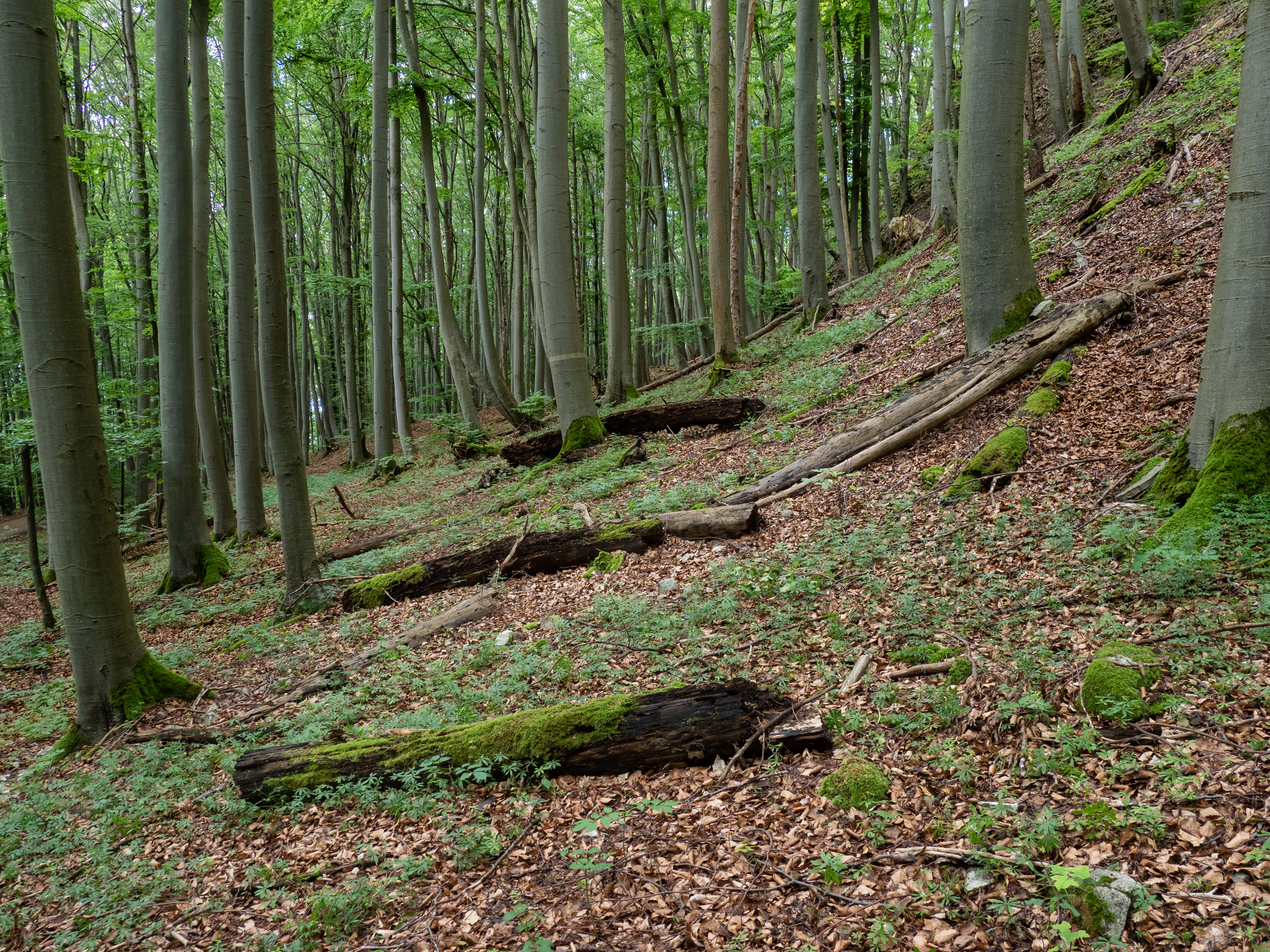
Kitschentalrangen forest
A view of the Kitschentalrangen nature forest reserve

Naturwald Vierzehnheiligen history and protected-area timeline

The oldest protected portion of the present-day Naturwald Vierzehnheiligen is the Kitschentalrangen nature forest reserve, which has been formally protected since 1978. For decades this small core quietly demonstrated the ecological value of letting beech, oak and hornbeam stands develop without timber extraction.

A much larger chapter began with the Bavarian Volksbegehren on biodiversity and natural beauty in 2019, a popular initiative that pushed the state government to commit to substantially expanding strict forest reserves. In June 2020 this political commitment was translated into practice, and the expanded Naturwald Vierzehnheiligen was formally designated, bringing the previously existing reserve into a much larger 541-hectare protected mosaic.

The designation reflects Article 12a of the Bavarian Forest Act and contributes to a national German strategy that seeks to remove approximately five percent of the country's forests from active management. The area is administered by the Bayerische Staatsforsten under this reserve framework rather than as a traditional commercial forest.

Naturwald Vierzehnheiligen landscape and geographic character

The protected landscape is shaped by the foothills of the northern Franconian Jura, where limestone uplands break into steeper wooded slopes and small valleys. The forest occupies these slope and ridge systems rather than flat lowlands, climbing over transitions between dry rock-influenced sites and more sheltered, moist draws.

The terrain includes dramatic breaks where Malmschutt has rolled over an underlying Ornatenton terrace, producing steep, unstable sections that favor old, twisted trees and high structural diversity in the canopy. Narrow, shaded stream channels cut through the property, and the eastern and southern margins abut small Franconian villages such as Klosterlangheim, Mistelfeld, and Lahm bei Lichtenfels.

Beyond the reserve itself lie neighboring features that help frame the scenery: the Staffelberg to the southwest, a distinctive Franconian Jura hill crowned by a memorial and long-distance views, and the broader rock-and-slope woodlands of the Naturpark Fränkische Schweiz. Together these create the characteristic alternating mosaic of woodland, rocky pasture and small valley settlements of the region.

Naturwald Vierzehnheiligen ecosystems, habitats, and plant life

Vegetation in the reserve is exceptionally varied for a Central European forest, reflecting the strong contrast in geology, moisture and slope within a relatively small area. Beechwoods of several different community types dominate, from the widespread woodrush beech forest on more acidic substrates to the woodruff beech forest on richer sites and the rare orchid beech forest on calcareous, humus-rich soils.

Where oak gains ground over beech, the forest transitions into oak-hornbeam woodlands of both the Galium and Stellaria types, rich in herbs and shrubs. Steeper slope breaks and cool, humid gorges support a distinct slope and ravine mixed forest of sycamore, wych elm, ash and lime, while alder and ash forest threads along the small brooks that drain the area.

Older portions of the forest have been shaped by centuries of minimal interference. Stands include pedunculate oak, small-leaved lime, hornbeam, field maple, wild service tree (Elsbeere) and whitebeam (Mehlbeere). These veteran and multi-aged trees, along with abundant standing and fallen deadwood, create the structural features on which many of the reserve's most characteristic species depend.

Naturwald Vierzehnheiligen wildlife and species highlights

The forest's combination of old broadleaved trees, frequent deadwood and connected canopy makes it an unusually strong habitat for species that require mature, undisturbed woodland. Several bat species of conservation concern are present, including the Bechstein's bat and the extremely rare, reclusive whiskered bat (Mopsfledermaus), both of which depend on tree cavities and old growth.

The bird community is similarly distinctive, with numerous woodpecker species including black, middle, lesser, grey and green woodpeckers. Other characteristic forest birds include stock dove, golden oriole, pied flycatcher, honey buzzard, Eurasian pygmy owl, Eurasian scops owl and eagle owl. The eagle owl in particular highlights the value of the reserve's undisturbed rocky slopes and old trees.

Beneath the canopy the reserve supports fire salamanders, a rich array of saproxylic insects that depend on deadwood, and a notably diverse mollusk fauna, unusual for a Central European forest. These groups together indicate long ecological continuity rather than recent rewilding from disturbed land.

Naturwald Vierzehnheiligen conservation status and protection priorities

Strict non-intervention management is the central conservation tool. Commercial forestry is excluded, and even most traditional habitat interventions are avoided; only measures genuinely needed for forest protection, such as pest or disease responses, and for visitor safety are permitted. This approach aligns with the Article 12a provisions of the Bavarian Forest Act.

The reserve contributes to Germany's national strategy to remove roughly five percent of the forest estate from any form of timber extraction, providing a large reference area where natural forest dynamics, including regeneration, gap formation, deadwood accumulation and tree mortality, can be observed in a region otherwise long shaped by forestry.

On the European scale, the area is fully integrated into the Natura 2000 network: the entire forest sits within the FFH site Waldgebiete Buchrangen und Spendweg and the broader Special Protection Area for birds that covers the rocky and slope forests of the northern Franconian Jura. International classification is complicated by the fact that the site has not been formally reported to the IUCN and may not meet the size thresholds of IUCN protected-area categories.

Top sights and standout views in Naturwald Vierzehnheiligen

The reserve stands out for the unusual scale at which near-natural deciduous forest has been set aside in Bavaria, blending a 1970s-era nature forest reserve with a much larger 2020 expansion to create a single strictly protected area of over 500 hectares.

It is also notable for the depth of its wildlife communities relative to a relatively small footprint: a high concentration of rare bats, multiple woodpecker species, large owls, fire salamanders and an exceptionally diverse mollusk fauna all coexist within a single forest mosaic that includes beech, oak-hornbeam, slope and ravine woodland types.

Monthly climate preview

Long term temperature and precipitation patterns measured at representative coordinates

Naturwald Vierzehnheiligen Climate Normals and Annual Weather Rhythm

Representative coordinate records show average temperatures ranging from sub-zero winter lows to warm summer highs alongside consistent monthly precipitation values. Exploring the full twelve month profile reveals detailed temperature shifts and precipitation metrics across the protected area.
Annual mean8 °C
-2 °C19 °C
Jan-2°
Feb-1°
Mar
Apr
May13°
Jun16°
Jul19°
Aug19°
Sep14°
Oct
Nov
Dec-1°
Warmest month
July

18.7 °C

Coolest month
January

-1.9 °C

Wettest month
July

2.7 mm/day

Driest month
April

1.4 mm/day

Park location guide

Geography guide, regional context, and park location map for Naturwald Vierzehnheiligen

Naturwald Vierzehnheiligen park geography, regions, and map view in Germany

Understand where Naturwald Vierzehnheiligen sits in Germany through a broader geographic reading of the surrounding landscape, nearby location context, and its mapped position within the national park landscape.

How Naturwald Vierzehnheiligen fits into Germany

Germany is a federal republic in Western and Central Europe with a population of over 83 million across sixteen constituent states. It is Europe's largest economy by nominal GDP and a major global exporter and importer. The capital is Berlin, and the country borders Denmark, Poland, Czech Republic, Austria, Switzerland, France, Luxembourg, Belgium, and the Netherlands.

Wider geography shaping Naturwald Vierzehnheiligen in Germany

Germany is located in Western and Central Europe, spanning 357,022 km². It borders Denmark to the north, Poland and the Czech Republic to the east, Austria and Switzerland to the south, and France, Luxembourg, Belgium, and the Netherlands to the west. The country has coastlines on the Baltic Sea and North Sea to the north, with the Alps located in the southern region.

Map view of Naturwald Vierzehnheiligen

Use this park location map to pinpoint Naturwald Vierzehnheiligen in Germany, understand its exact geographic position, and read its mapped placement within the surrounding landscape more clearly.

Pigeon | © OpenStreetMap contributors

Location context for Naturwald Vierzehnheiligen

Bavaria

Visual reference for the broadleaved woodlands, steep terrain, and habitats of Upper Franconia

Naturwald Vierzehnheiligen Photos and Protected Forest Landscape Scenery

Explore detailed visual records of Naturwald Vierzehnheiligen, capturing the mature beech stands and steep limestone slopes of the northern Franconian Jura. These field photographs illustrate the complex canopy structures and shaded stream valleys that define the protected forest environment.

Kitschentalrangen forest

Park atlas

Compare adjacent forest reserves and regional protected areas across Upper Franconia

Explore Parks Near Naturwald Vierzehnheiligen and Surrounding Protected Landscapes

Browse nearby national parks and connected woodland reserves to compare regional protected landscapes and terrain types. Continuing from Naturwald Vierzehnheiligen reveals the broader ecological spread of the northern Franconian Jura.
Protected landscapeBavaria
Mapped location lies within the park boundary#1 closest

Southeast

Naturpark Fränkische Schweiz, Frankenjura: An Atlas of Bavarian Karst and Forested Landscapes

Protected landscape geography within the northern Franconian Jura.

Naturpark Fränkische Schweiz, Frankenjura is a landmark protected area covering over 2,300 square kilometers across Bavaria. Its terrain is defined by a rhythmic sequence of limestone plateaux, winding river valleys, and dolomite formations, balanced by the quieter, pine-dominated reaches of the Veldensteiner Forst. This atlas entry details the park's geological complexity and its significant role in regional conservation.

Area
2,335.44 km²
Established
1968
Relief
Upland
Climate
Temperate
Protected landscapeBavaria
About 15 km away#2 closest

Northeast

Naturpark Frankenwald: Geographic Profile of Bavaria's Forested Protected Landscape

A vast, interconnected upland spanning the Bavaria and Thuringia border

Naturpark Frankenwald functions as a large-scale managed nature preserve that integrates cultural heritage with ecological conservation. The terrain consists of gentle mountainous ridges, narrow river valleys, and extensive mixed forests that form a continuous landscape belt across northern Bavaria. This profile provides an overview of the regional geography, boundary extent, and the natural features that define this significant central German upland area.

Area
1,023 km²
Established
1973
Relief
Upland
Climate
Temperate
Nature reserveBayern
About 31 km away#3 closest

Southwest

Naturwald Wasserwand Nature Reserve: Mapped Protected Forests of Upper Franconia, Bayern

An undisturbed oak and beech woodland within the Bruderwald forest plateau.

Naturwald Wasserwand represents a core node in the protected forest network surrounding Bamberg, Bayern. This nature reserve, spanning 30 hectares, focuses on preserving near-natural forest processes through the exclusion of active timber management. The site provides a unique opportunity to study the development of mature broadleaf stands in a transitional zone between suburban expansion and the rural Franconian countryside.

Area
0.291 km²
Established
2022
IUCN
IV
Relief
Lowland
Nature reserveOberfranken
About 31 km away#4 closest

Southwest

Naturwald Wolfsruhe Protected Forest Reserve: An Oberfranken Geography and Atlas Overview

Analyzing the forest composition and Keuper escarpment landscape

Naturwald Wolfsruhe is a protected nature reserve in Oberfranken that showcases a unique forest ecosystem shaped by former coppice-with-standards management. This site offers valuable insight into the biodiversity of the Franconian Keuper-Lias region, where pedunculate oak stands and varied soil substrates create a distinct natural landscape south of Bamberg.

Area
0.465 km²
Established
1978
IUCN
IV
Relief
Lowland
Nature reserveThuringia
About 36 km away#5 closest

Northwest

Am Pfingsthut Nature Reserve: Mapped Protected Landscapes in Southern Thuringia

Historic woodland habitat and regional conservation mosaic.

Located in the district of Hildburghausen, Am Pfingsthut represents a significant nature reserve with over fifty years of conservation history. The site contributes to a connected regional network of protected forested habitats and open meadows, showcasing the transition between rural settlement areas and the natural terrain of southern Germany.

Area
0.334 km²
Established
1967
IUCN
IV
Nature reserveThuringia
About 36 km away#6 closest

Northwest

Werra bis Treffurt mit Zuflüssen: Protected River and Floodplain Network in Thuringia

Mapping an extensive 191 kilometer Natura 2000 river corridor.

The Werra bis Treffurt mit Zuflüssen protected area serves as a vital ecological corridor in Thuringia. This site encompasses a complex mosaic of fast-flowing highland brooks, expansive floodplain meadows, inland salt sites, and rare dissolution lakes. Its geography bridges high-altitude source regions with lower river valleys, creating a distinctive landscape transect that supports essential freshwater habitats and rare aquatic species across the state.

Area
22.6 km²
Established
2008
IUCN
IV
Relief
Mixed relief
Nature reserveThuringia
About 37 km away#7 closest

Northwest

Lachenwäldchen Nature Reserve: Protected Woodland Geography in Southern Thuringia

Mapping forest habitats and biodiversity in the Hildburghausen district

Lachenwäldchen is a 45.8 hectare nature reserve in Thuringia, Germany, providing a stable forest microclimate for saproxylic insects and beetle species. Its position within the rural landscape near Heldburg showcases the significance of compact, preserved woodland patches for regional conservation efforts and ecological connectivity in southern Germany.

Area
0.458 km²
Established
1961
IUCN
IV
Relief
Upland
Nature reserveLandkreis Haßberge
About 42 km away#8 closest

Southwest

Schulterbachtal Nature Reserve: Mapped Geography and Protected Wetland Landscapes in Bavaria

A focused analysis of the Steigerwald wetland and brook habitats

Schulterbachtal occupies a protected valley floor within the Haßberge district, characterized by its near-natural stream, extensive wet meadow communities, and characteristic alder-ash woodland belts. As a key segment of the northern Steigerwald ecosystem, this site demonstrates the ecological significance of managed cultural landscapes and provides a detailed view of its hydrological and vegetative terrain.

Area
0.341 km²
Established
1990
IUCN
IV

Common questions about visiting, size, designation, and location context for Naturwald Vierzehnheiligen

Naturwald Vierzehnheiligen FAQs for park facts, access, geography, and protected area context

Find quick answers about Naturwald Vierzehnheiligen, including protected-area facts, park geography, trail and visitor context, and how the park fits into its surrounding country and regional landscape.
MoriAtlas Explorer

Continue Your Protected Areas Search Across the Global Atlas

Deepen your exploration by continuing the structured search for national parks and protected areas worldwide. Utilize the comprehensive filtering capabilities to compare different conservation landscapes and refine your understanding of global park geography. Discover more about the distribution and characteristics of protected natural areas.

Global natural geography