
Mori Atlas logo
Protected landscapeNellingen

Mapping the cultural and ecological features of this central Swabian protected area

Nellingen Protected Landscape: Geographic Analysis of the Swabian Alb Hill and Basin Terrain

(Landschaftsschutzgebiet „Nellingen“)

The Nellingen Protected Landscape preserves a distinct portion of the Kuppenalb plateau within the Swabian Alb. This region features a mosaic of dry valleys, limestone hilltops, and traditional orchards that illustrate the deep connection between Jurassic geology and historic land management. Our mapping analysis traces the boundaries and landscape character of this conservation area, highlighting the interplay of juniper heaths, calcareous grasslands, and dry-stone structures within the Alb-Donau-Kreis district.

protected landscapeLandschaftsschutzgebietSwabian AlbKuppenalbdry valleysjuniper heath
Digital illustration of a serene landscape at sunset, featuring rolling green hills, a curving dirt path, a dense forest on the right, and three wind turbines in the distance against a pink and orange sky.

Nellingen

Protected landscape

Park overview

Structured park overview, official facts, and landscape profile for Nellingen Protected Landscape

Nellingen Protected Landscape park facts, protected area profile, and essential visitor context

Review the core facts for Nellingen Protected Landscape, including designation, size, terrain, visitor scale, habitats, and operating context in one park-focused overview.

About Nellingen Protected Landscape

Nellingen Protected Landscape (Landschaftsschutzgebiet „Nellingen“) is a protected countryside area in the Alb-Donau-Kreis, situated in the eastern part of the German state of Baden-Württemberg. It sits on the Swabian Alb, the karstic plateau formed from Jurassic limestone that runs across southern Germany, and is specifically located at the transition between two of its natural regions: the Mittlere Kuppenalb (Middle Kuppenalb) and the Albuch und Härtsfeld. The plateau's geological history is central to the character of the protected area, since the gentle uplift and subsequent erosion of the limestone layers have produced the rolling topography of Kuppen, hollows, dolines and dry valleys that defines this part of the Alb.

In ecological and cultural terms, the area is best understood as a working cultural landscape. Although often described as semi-natural, the habitats protected here have been shaped over centuries by grazing, hay-cutting, orchard management and the careful maintenance of small field structures. Juniper heaths (Wacholderheiden) and nutrient-poor grasslands (Magerrasen) reflect historic sheep grazing and the low productivity of the dry, lime-rich soils. Traditional orchards (Streuobstwiesen) supply fruit trees in an open, park-like arrangement that has both cultural and biodiversity value. Field hedges, dry-stone walls and isolated mature trees or tree groups add structural diversity to the landscape, providing nesting sites, corridors and visual texture.

The protected area consists of several parcels around the municipality of Nellingen rather than a single contiguous block. This fragmented arrangement reflects the way that particularly valuable landscape features are interspersed with the surrounding settlements and farmland, so protection is concentrated on the most ecologically and aesthetically significant sections. The area's unbuilt scenery and locally distinctive landforms also serve a recreational function, providing nearby residents with a quiet countryside for walking and nature observation close to the village.

Within the wider conservation network of the Swabian Alb, Nellingen Protected Landscape connects to several other designations. The Mönchsteig nature reserve lies to the south, while the Vögelestal und Oberes Lontal nature reserve borders it to the north. The protected area also overlaps with the European Natura 2000 site Kuppenalb bei Laichingen und Lonetal, an FFH (Habitats Directive) area, and is adjacent to other landscape protection areas such as those of Merklingen and Dornstadt. Several designated natural monuments (Naturdenkmale) within its borders include a sinkhole doline with a pond and woodland, three former clay pits, and a stand of trees on a former sheep pasture. IUCN has classified the site under Category V, reflecting its role as a Protected Landscape where human land use and natural values are managed together.

Quick facts and research context for Nellingen Protected Landscape

Nellingen Protected Landscape is a German Landschaftsschutzgebiet (landscape protection area) located in the Alb-Donau-Kreis district of Baden-Württemberg. It was established by ordinance of the Regierungspräsidium Nordwürttemberg and dates to September 1999. The site covers approximately 1,521 hectares across several parcels arranged around the municipality of Nellingen on the Swabian Alb plateau. It is classified as IUCN Category V (Protected Landscape/Seascape) and is administered at the district level. The area is characterized by a typical Kuppenalb mosaic of dry valleys, hilltops and depressions, enriched by juniper heaths, nutrient-poor grasslands, orchards and traditional field structures.

Protection and recognition

Explore documented protection records and management frameworks for Nellingen.

Nellingen Protection Status and Terrestrial Conservation Registry

Terrestrial conservation records for Nellingen compile documented protection status and baseline management parameters. Global protected area databases supply verified administrative details for comprehensive analysis.

Protection details

Protection scope
Terrestrial
WDPA ID
323170
Park context

Deeper park guide and search-rich context for Nellingen Protected Landscape

Nellingen Protected Landscape history, landscape, wildlife, and travel context

Explore Nellingen Protected Landscape through its history, landscape character, ecosystems, wildlife, conservation priorities, cultural context, and seasonal travel timing in a structured park guide built for atlas discovery and search intent.

Why Nellingen Protected Landscape stands out

Nellingen Protected Landscape is best known for preserving a representative and visually striking example of the Kuppenalb, the hill-and-basin terrain of the central Swabian Alb. Its identity is rooted in the interplay between the underlying Jurassic geology, which has produced the dry valleys, dolines and Kuppen, and the centuries of agricultural land use that have shaped the current character of the countryside. The cultural landscape features are just as defining as the natural landforms. Wacholderheiden (juniper heaths), Magerrasen (poor grasslands), Streuobstwiesen (traditional orchards), Steinriegel (dry-stone wall field boundaries), Feldhecken (field hedges) and scattered old trees express a long continuity of low-intensity land management. These elements together give the protected area its ecological richness and its distinctive scenic quality within the broader Swabian Alb region.
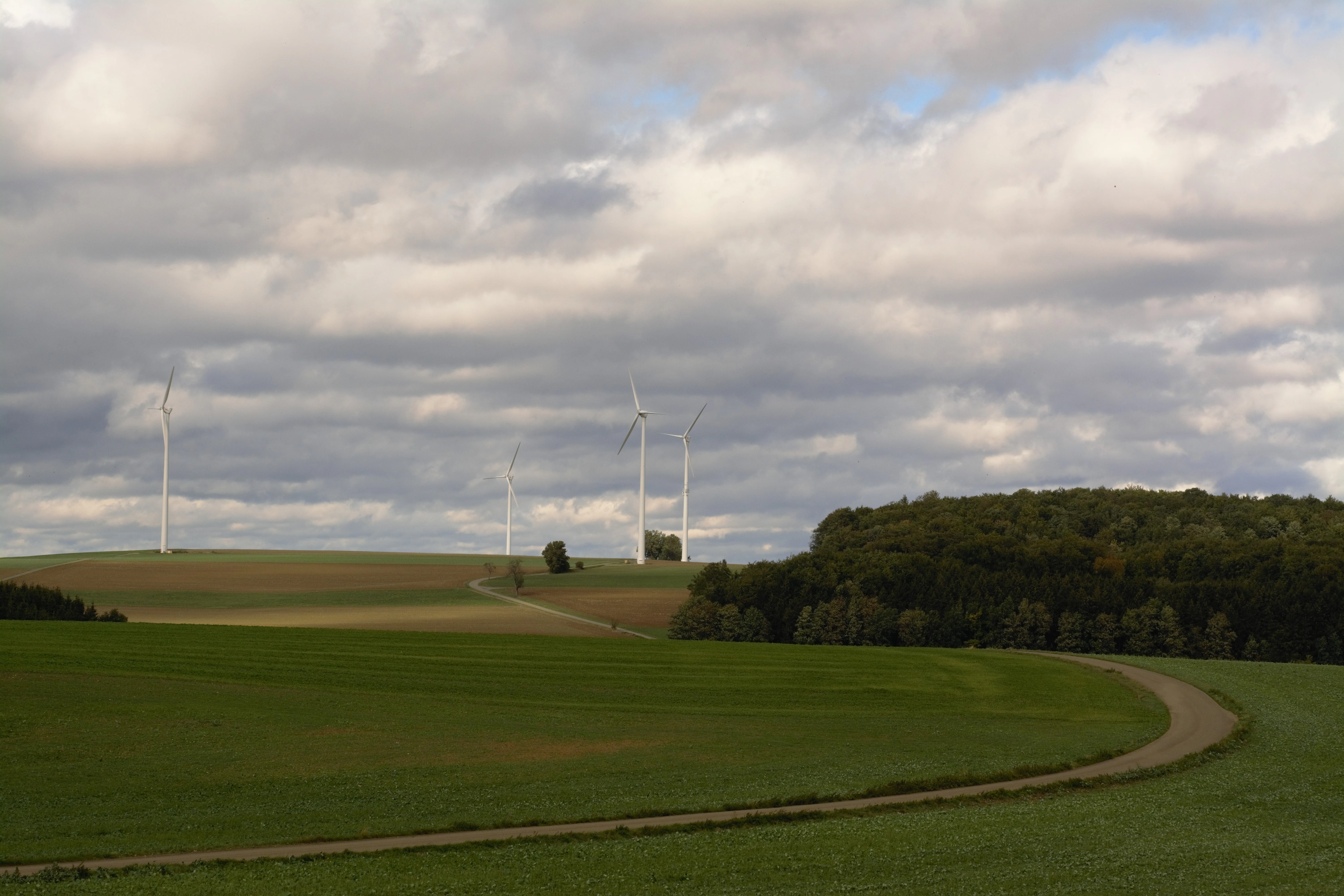
A wide view of a rolling green agricultural landscape with a dirt path winding through fields and wind turbines in the distance under a cloudy sky.
Agricultural landscape and wind turbines near Oppingen in the Nellingen region.

Nellingen Protected Landscape history and protected-area timeline

The Nellingen Protected Landscape was established on 20 September 1999 by ordinance of the Regierungspräsidium Nordwürttemberg, the regional administrative authority responsible for much of northern Württemberg. Like other Landschaftsschutzgebiete in Baden-Württemberg, its creation was part of the state's broader effort to maintain the visual, ecological and cultural characteristics of representative countryside outside of strictly protected nature reserves.

The protected area's statutory purpose reflects the longstanding recognition that the Kuppenalb landscapes around Nellingen are the result of a long interaction between geology, climate and human land management. By setting aside the most characteristic sections of dry valleys, hilltops, juniper heaths, orchards and traditional field structures, the ordinance acknowledged the value of preserving the working agricultural landscape rather than only its strict nature zones. Subsequent alignment with European habitat protection, through overlap with the FFH area Kuppenalb bei Laichingen und Lonetal, has reinforced its role within the wider conservation network of the Swabian Alb.

The local administration of the area falls under the Alb-Donau-Kreis district, which remains the primary body coordinating land-use planning and conservation oversight within the boundaries of the protected landscape.

Nellingen Protected Landscape landscape and geographic character

The landscape of Nellingen Protected Landscape is defined by the classic morphology of the Mittlere Kuppenalb and the adjacent Albuch und Härtsfeld subregions of the Swabian Alb. The underlying Jurassic limestone has been weathered over millions of years into a mosaic of gently rounded Kuppen (hilltops), shallow sinkholes and a network of Trockentäler (dry valleys) that lack permanent surface water because rainfall drains through the karstic rock. This combination of open hilltops, dropout hollows and descending dry valleys gives the area its recognizable, undulating character and produces many of the viewpoints that contribute to the visual quality of the protected countryside.

A particular landform feature within the protected area is a Trichterdoline, or funnel-shaped sinkhole, with an associated Hüle, a traditional small pond or water hollow. Sinkholes and other shallow depressions on the Swabian Alb often collect slightly more moisture and finer sediment than the surrounding slopes, producing locally distinct vegetation and microhabitats. The presence of three former Lehmgruben (clay pits) and a former Schafweide (sheep pasture) with its surviving tree growth indicates how the geological substrate and historic land use have jointly shaped the present-day features of the terrain.

Because the landscape is largely unbuilt, the visual interplay between open farmland, scattered woodland patches, hedgerows and orchards remains intact across the protected parcels. The result is a varied, aesthetically appealing countryside in which the geological foundations and the cultural land use are still clearly legible.

Nellingen Protected Landscape ecosystems, habitats, and plant life

Ecologically, Nellingen Protected Landscape represents a typical and well-developed example of the Swabian Alb's cultural landscape habitats. While the soils are generally thin and lime-rich, the diversity of landforms, exposures and historic management has produced a range of semi-natural vegetation types within a relatively modest area.

The Wacholderheiden (juniper heaths) are among the most characteristic plant communities. These open, shrub-dominated grasslands are relicts of past grazing pressure and contain specialist species adapted to dry, calcareous conditions. The associated Magerrasen (nutrient-poor grasslands) further enrich the botanical diversity of the area, often harbouring orchids and other uncommon wildflowers typical of the Swabian Alb.

Streuobstwiesen (traditional orchards) form another important habitat layer. These park-like arrangements of fruit trees, often old and structurally varied, support birds, bats and insects and are a hallmark of southern German agricultural heritage. Field hedges (Feldhecken), field margins (Feldraine), dry-stone wall rows (Steinriegel), scattered single trees and tree groups provide additional structural connectivity and refuge for wildlife. Together, these elements build a fine-grained mosaic in which different habitat types abut one another frequently, supporting species that depend on edges between open and sheltered environments.

Nellingen Protected Landscape wildlife and species highlights

Although the official description of the protected area focuses broadly on ecological and landscape values rather than species lists, the habitats present in Nellingen Protected Landscape provide homes for the kind of wildlife associated with the Swabian Alb's traditional countryside. The juniper heaths, poor grasslands and orchard meadows are particularly important for insects such as butterflies, wild bees and other pollinators, several of which are specialists of calcareous grasslands and old orchard habitats in this region.

Birds benefit from the combination of open ground, scattered trees, hedgerows and orchards. Typical species of this kind of Swabian cultural landscape include those associated with field edges, orchard meadows and dry valley slopes, as well as raptors and other predators that hunt across the mosaic of habitats. Small mammals, bats and reptiles also find refuge in the dry-stone walls, old trees, sinkholes and remaining field margins. Beyond the strictly protected boundaries, the surrounding dry valleys and neighbouring nature reserves such as Vögelestal und Oberes Lontal and Mönchsteig extend the available wildlife habitat.

Nellingen Protected Landscape conservation status and protection priorities

Nellingen Protected Landscape has been established with the explicit goal of preserving the diversity, character and beauty of the Kuppenalb countryside around Nellingen. Its conservation purpose, as stated in the founding ordinance, is to maintain the area's distinctive combination of landforms and land uses: Trockentäler (dry valleys), Kuppen (hilltops) and Senken (basins); ecologically valuable cultural landscape features such as field hedges, woodland patches, dry-stone walls, field margins, juniper heaths, nutrient-poor grasslands, scattered trees, tree groups and orchards; and the unbuilt, aesthetically appealing landscape parts that serve as locally and regionally significant recreation areas.

In practical terms, the protection seeks to keep the area free from development pressures, maintain the integrity of its traditional land management and preserve the visual relationship between geology and land use that defines the Kuppenalb. By overlapping with the Natura 2000 site Kuppenalb bei Laichingen und Lonetal, a European habitat protection area, the landscape is also tied into the continent-wide effort to conserve representative calcareous grassland and orchid-rich habitats. Internationally, the site is recorded in the World Database on Protected Areas under WDPA ID 323170, and IUCN classifies it as a Category V Protected Landscape, recognizing that long-established human land management is integral to its conservation value rather than incidental to it.

Nellingen Protected Landscape cultural meaning and human context

The protected landscape around Nellingen sits within a region of southern Germany where the rural past is unusually visible in the present-day scenery. Centuries of grazing, hay-making, fruit cultivation and careful boundary management have created a working countryside that is simultaneously a cultural inheritance and an ecological asset. The traditional Streuobstwiesen, in particular, are an iconic element of Swabian rural culture, providing fruit, timber and habitat while giving the wider landscape its distinctive park-like texture.

Other features such as Steinriegel (dry-stone walls), Feldraine (field margins) and the maintenance of Wacholderheiden reflect a continuity of small-scale, labour-intensive land practices that have shaped the Alb for generations. The Hüle, a traditional water feature associated with a local sinkhole, hints at how communities historically managed scarce water on the dry plateau. While the protected landscape ordinance does not single out intangible heritage, the protection of these features implicitly preserves the cultural landscape that local communities have tended over many generations.

Top sights and standout views in Nellingen Protected Landscape

Nellingen Protected Landscape preserves one of the more complete surviving examples of the central Swabian Alb's hill-and-basin topography, with dry valleys, sinkholes and characteristic Kuppen forming a continuous backdrop to the working farmland around Nellingen. What sets the area apart is the unusually rich combination of geological landforms and traditional cultural landscape structures: juniper heaths, poor calcareous grasslands, orchards, hedges and dry-stone boundaries together create a finely structured, ecologically valuable mosaic.

The area's integration into a wider conservation network, including adjacent nature reserves and the Natura 2000 site Kuppenalb bei Laichingen und Lonetal, adds to its importance. For visitors, the attraction is less about dramatic scenery and more about the layered, readable character of the countryside, where karstic geology, historic land management and an unspoiled rural environment are still closely intertwined.

Best time to visit Nellingen Protected Landscape

The Swabian Alb around Nellingen is rewarding in any season, but different times of year emphasize different qualities of the protected landscape. Late spring and early summer bring the richest display of wildflowers in the nutrient-poor grasslands and juniper heaths, when orchids and other calcareous specialists are at their peak and the orchards are in full leaf. Early summer evenings are also a good time to observe insects and birds in the hedgerows and field margins.

In autumn, the traditional orchards (Streuobstwiesen) become a focal point, both visually and culturally, as fruit ripens and leaves turn. Winter visits reveal the underlying structure of the landscape: the dry valleys, hilltops and dry-stone walls become more visible once vegetation dies back, and clear weather often produces excellent distant views across the Alb plateau. Snow on the Kuppenalb is uncommon but, when it falls, sharply highlights the area's rolling topography.

Monthly climate preview

Review measured monthly averages and long term climate data for Nellingen

Nellingen Climate Normals and Long Term Temperature and Precipitation Patterns

Long term representative measurements outline the annual temperature and precipitation rhythm across Nellingen, spanning average minimums to maximums from NASA POWER data. Reviewing the complete twelve month climate profile reveals detailed monthly fluctuations and broader meteorological context.
Annual mean8 °C
-1 °C18 °C
Jan-1°
Feb-1°
Mar
Apr
May12°
Jun16°
Jul18°
Aug18°
Sep13°
Oct
Nov
Dec-1°
Warmest month
July

17.8 °C

Coolest month
January

-1.5 °C

Wettest month
July

3.4 mm/day

Driest month
February

1.7 mm/day

Park location guide

Geography guide, regional context, and park location map for Nellingen Protected Landscape

Nellingen Protected Landscape park geography, regions, and map view in Germany

Understand where Nellingen Protected Landscape sits in Germany through a broader geographic reading of the surrounding landscape, nearby location context, and its mapped position within the national park landscape.

How Nellingen Protected Landscape fits into Germany

Germany is a federal republic in Western and Central Europe with a population of over 83 million across sixteen constituent states. It is Europe's largest economy by nominal GDP and a major global exporter and importer. The capital is Berlin, and the country borders Denmark, Poland, Czech Republic, Austria, Switzerland, France, Luxembourg, Belgium, and the Netherlands.

Wider geography shaping Nellingen Protected Landscape in Germany

Germany is located in Western and Central Europe, spanning 357,022 km². It borders Denmark to the north, Poland and the Czech Republic to the east, Austria and Switzerland to the south, and France, Luxembourg, Belgium, and the Netherlands to the west. The country has coastlines on the Baltic Sea and North Sea to the north, with the Alps located in the southern region.

Map view of Nellingen Protected Landscape

Use this park location map to pinpoint Nellingen Protected Landscape in Germany, understand its exact geographic position, and read its mapped placement within the surrounding landscape more clearly.

Pigeon | © OpenStreetMap contributors

Location context for Nellingen Protected Landscape

Baden-Wuerttemberg

Visualizing the hilltops, dry valleys, and juniper heaths of the Swabian Alb

Nellingen Landscape Photos and Protected Area Scenery

Photographic records capture the undulating karst terrain, traditional orchards, and dry-stone boundaries defining the protected countryside around Nellingen. Visual exploration reveals the geological formations and semi-natural habitats shaping the character of the Swabian Alb region.

A wide view of a rolling green agricultural landscape with a dirt path winding through fields and wind turbines in the distance under a cloudy sky.

Park atlas

Compare regional karst terrain and adjacent conservation landscapes across the Swabian Alb

Explore Other Parks and Protected Areas Near Nellingen in Baden-Württemberg

Browse protected areas and natural reserves located near Nellingen to compare similar limestone geology and traditional rural terrain. Continuing through these surrounding designations reveals the broader ecological patterns of the central Swabian plateau.
Protected landscapeBaden-Württemberg
About 7.7 km away#1 closest

West

Oberes Filstal-Gemeinde Mühlhausen im Täle: Protected Landscape Geography and Map Data

Swabian Alb regional landscape and habitat mosaic

Analyze the protected landscape of Oberes Filstal-Gemeinde Mühlhausen im Täle through its unique physical terrain and ecological structure. This area in the Göppingen district features a complex interplay of river valleys and plateau uplands, creating a habitat corridor that links the Fils valley with the wider Swabian Alb, supporting diverse flora and traditional land-use patterns.

Area
5.13 km²
Established
1983
IUCN
V
Protected landscapeBaden-Württemberg
About 7.8 km away#2 closest

North

Weigoldsberg Protected Landscape: Mapped Terrain in the Swabian Alb of Baden-Württemberg

A contiguous hill-landscape with integrated Natura 2000 ecological zones

Weigoldsberg functions as a coherent protected landscape unit within the Mittlere Kuppenalb, spanning the transition between upland terrain and the Fils valley. This area integrates near-natural forest, traditional meadow mosaics, and high-value ecological zones such as the Filsalb FFH and Mittlere Schwäbische Alb bird protection area. Gain insights into its relief, land use patterns, and conservation designation.

Area
2.16 km²
Established
1975
IUCN
V
Relief
Mountain
Watercolor illustration of rolling green hills, trees, and wildflowers, with a soft, bright, and light aesthetic.
Protected landscapeBaden-Württemberg
About 10 km away#3 closest

West

Oberes Filstal-Stadt Wiesensteig: Protected Landscape and Regional Geography Mapping

An atlas overview of the Mittlere Kuppenalb landscape mosaic

Covering roughly 171 hectares around Wiesensteig, this protected area serves as a vital component of the central Swabian Alb geography. The site features an undulating karst terrain characterized by a dense forest mosaic, hedgerows, and historic pastoral features. Through its alignment with local Natura 2000 sites, it forms a cohesive ecological bridge between the upper Fils valley and the surrounding high plateau.

Area
1.71 km²
Established
1985
IUCN
V
Relief
Highland
A soft watercolor illustration showing a rolling landscape with gentle hills, grassy fields, and tree lines in shades of green, yellow, and faint pink.
Protected landscapeBaden-Württemberg
About 12 km away#4 closest

Northwest

Oberes Filstal-Gemeinde Gruibingen: Protected Landscape and Regional Geography

Swabian Alb terrain within the Göppingen district

Oberes Filstal-Gemeinde Gruibingen forms a crucial ecological envelope around specialized nature reserves on the Swabian Alb. The landscape is defined by its characteristic kuppen hill-and-basin topography, featuring ridge slopes, stream-cut valleys, and traditional agricultural land that supports high floristic diversity within the Baden-Württemberg region.

Area
1.71 km²
Established
1984
IUCN
V
A soft watercolor painting depicting rolling green hills and meadows against a white background.
Protected landscapeBaden-Württemberg
About 12 km away#5 closest

West

Neidlinger Tal Protected Landscape: Regional Geography and Mapped Boundaries

A study of the Swabian Alb and Alb foreland transition terrain

The Neidlinger Tal protected landscape represents a vital intersection of natural regions in Baden-Württemberg. Its boundaries encompass a mosaic of forest and farmland, providing a comprehensive look at how historical land use patterns coexist with modern conservation efforts within the Swabian Alb, including various bird and habitat protection designations.

Area
10.959 km²
Established
1975
IUCN
V
Relief
Upland
Faint watercolor illustration of rolling green hills and a pinkish foreground against a white background.
Protected areaBaden-Württemberg
About 12 km away#6 closest

Northeast

Albtrauf Donzdorf-Heubach: Protected Escarpments and Karst Terrain in the Swabian Alb

Natura 2000 protected area in eastern Baden-Württemberg

The Albtrauf Donzdorf-Heubach site comprises eight protected parcels along the Swabian Alb. Its geography is defined by steep limestone cliffs, dissected valleys, and extensive karst systems that support specialized biodiversity. This protected landscape highlights the complex interaction between Upper Jurassic geological formations and traditional land-use patterns across the Göppingen and Ostalbkreis districts.

Area
25.333 km²
Established
2019
Relief
Highland
Climate
Temperate
A pale, soft-toned watercolor painting depicting a gentle, rolling landscape with green fields, distant hills, and sparse clusters of trees.
Protected landscapeBaden-Württemberg
About 13 km away#7 closest

West

Sommerschafweide hinter dem Hockenden Stein, Auchtweide Protected Landscape and Map

Historic Swabian Alb pasture and geological Kanzel terrain

Discover the geographic layout of Sommerschafweide hinter dem Hockenden Stein, Auchtweide, a protected area in Baden-Württemberg. This site highlights traditional grazed Magerrasen, mature pasture beeches, and the striking geological rock formation known as the Hockender Stein, offering insight into the conservation of the Mittlere Kuppenalb cultural landscape.

Area
0.065 km²
Established
1955
IUCN
V
Relief
Upland
Protected landscapeBaden-Württemberg
About 15 km away#8 closest

Northwest

Weilheim an der Teck auf Gemarkungen Weilheim und Hepsisau Protected Landscape Atlas

Volcanic hill geography in the Baden-Württemberg region

This protected area safeguards a richly structured landscape where rolling foothills meet the steep escarpments of the Swabian Alb. Centered on the volcanic peaks of Limburg and Egelsberg, the region maintains a vital balance between forest corridors and open agricultural plains within the district of Esslingen.

Area
13.615 km²
Established
1979
IUCN
V

Common questions about visiting, size, designation, and location context for Nellingen Protected Landscape

Nellingen Protected Landscape FAQs for park facts, access, geography, and protected area context

Find quick answers about Nellingen Protected Landscape, including protected-area facts, park geography, trail and visitor context, and how the park fits into its surrounding country and regional landscape.
MoriAtlas Explorer

Continue Your Protected Areas Search Across the Global Atlas

Deepen your exploration by continuing the structured search for national parks and protected areas worldwide. Utilize the comprehensive filtering capabilities to compare different conservation landscapes and refine your understanding of global park geography. Discover more about the distribution and characteristics of protected natural areas.

Global natural geography