

Mori Atlas logo
Protected landscapeNeuhausen-Biet

Mapping the distinctive mosaic of Würm valley floors, forest ridges, and orchard-dotted agricultural terrain

Neuhausen-Biet: A Significant Protected Landscape Linking the Gäu Plateaus and Black Forest Fringe

(Landschaftsschutzgebiet „Neuhausen-Biet)

Neuhausen-Biet represents a crucial 1,927-hectare protected landscape within the Enzkreis district of southwestern Germany. This region functions as a vital ecological corridor, bridging the transition between the open agricultural Gäu plateaus and the dissected forest slopes of the Northern Black Forest fringe. Through structured mapping, observers can trace the interplay of the Würm river valley, secluded side valleys like the Monbach, and the varied patchwork of meadows and woodlands that define this representative southwestern German terrain.

protected landscapeLandschaftsschutzgebietEnzkreisBaden-WürttembergGäu plateauBlack Forest fringe

Neuhausen-Biet

Protected landscape

Park overview

Structured park overview, official facts, and landscape profile for Neuhausen-Biet

Neuhausen-Biet park facts, protected area profile, and essential visitor context

Review the core facts for Neuhausen-Biet, including designation, size, terrain, visitor scale, habitats, and operating context in one park-focused overview.

About Neuhausen-Biet

Neuhausen-Biet is one of the more compact yet structurally varied protected landscapes in the Enzkreis, in the northwestern part of Baden-Württemberg. Although the area covers only about 1,927 hectares, it spans two clearly different natural regions, the Obere Gäue to the north and east, and the Schwarzwald-Randplatten (Black Forest fringe plateaus) to the west and south. This makes it ecologically richer than its modest size would suggest.

Geographically, the protected area centers on the municipality of Neuhausen and follows the topography of the Würm river valley and its tributary valleys. The landscape alternates between flat plateau surfaces used for agriculture and pastures, valley slopes that grade into woodland, and narrow side valleys with more natural, near-closed forest cover. Small settlements and the main built-up areas of the municipality are excluded from the protection, so the protected zone acts as a continuous ring and valley system around the inhabited core.

Neuhausen-Biet is also structurally important for regional nature conservation. It borders the nature reserves Klebwald, Monbach / Maisgraben / St. Leonhardquelle, and Unteres Würmtal, and a small portion of its territory lies within the FFH site 7118-341 Würm-Nagold-Pforte. Together with adjoining protected landscapes in the Enzkreis, Neuhausen-Biet forms part of a larger biotope network connecting the Black Forest with the Gäu plateaus of the Neckar and Tauber region.

Quick facts and research context for Neuhausen-Biet

Neuhausen-Biet was established on 26 August 2004 by regulation of the Landratsamt Enzkreis. It carries the official protected area number 2.36.041 and is classified under IUCN Category V (Protected Landscape/Seascape), which is the category generally used for German Landschaftsschutzgebiete.

The protected landscape is administered by the Landratsamt Enzkreis and is documented in the national World Database on Protected Areas under WDPA ID 325168. Its boundaries and management framework are integrated into the Baden-Württemberg state register of protected areas maintained by the Landesanstalt für Umwelt.

Protection and recognition

Terrestrial conservation framework and official protected area records

Neuhausen-Biet Protection Status and Designated Area Recognition

Terrestrial protection status for Neuhausen-Biet encompasses recorded management scope and administrative attributes. Verified records compile official designation data to support comprehensive conservation analysis.

Protection details

Protection scope
Terrestrial
Transboundary protection
No
WDPA ID
325168
Park context

Deeper park guide and search-rich context for Neuhausen-Biet

Neuhausen-Biet history, landscape, wildlife, and travel context

Explore Neuhausen-Biet through its history, landscape character, ecosystems, wildlife, conservation priorities, cultural context, and seasonal travel timing in a structured park guide built for atlas discovery and search intent.

Why Neuhausen-Biet stands out

Neuhausen-Biet is known primarily for preserving the visual and ecological transition zone between the agricultural Gäu landscape and the forested edge of the Black Forest. Its most recognizable features are the Würm river valley, the side valleys such as the Monbach valley on the edge of the protected zone, and the patchwork of meadows, orchards, fields, and forest blocks that surrounds the municipality of Neuhausen. The area also stands out for how strongly it functions as connective habitat: it borders several nature reserves and partly overlaps the FFH site "Würm-Nagold-Pforte", reinforcing its role as a link within a larger Black Forest fringe biotope network.
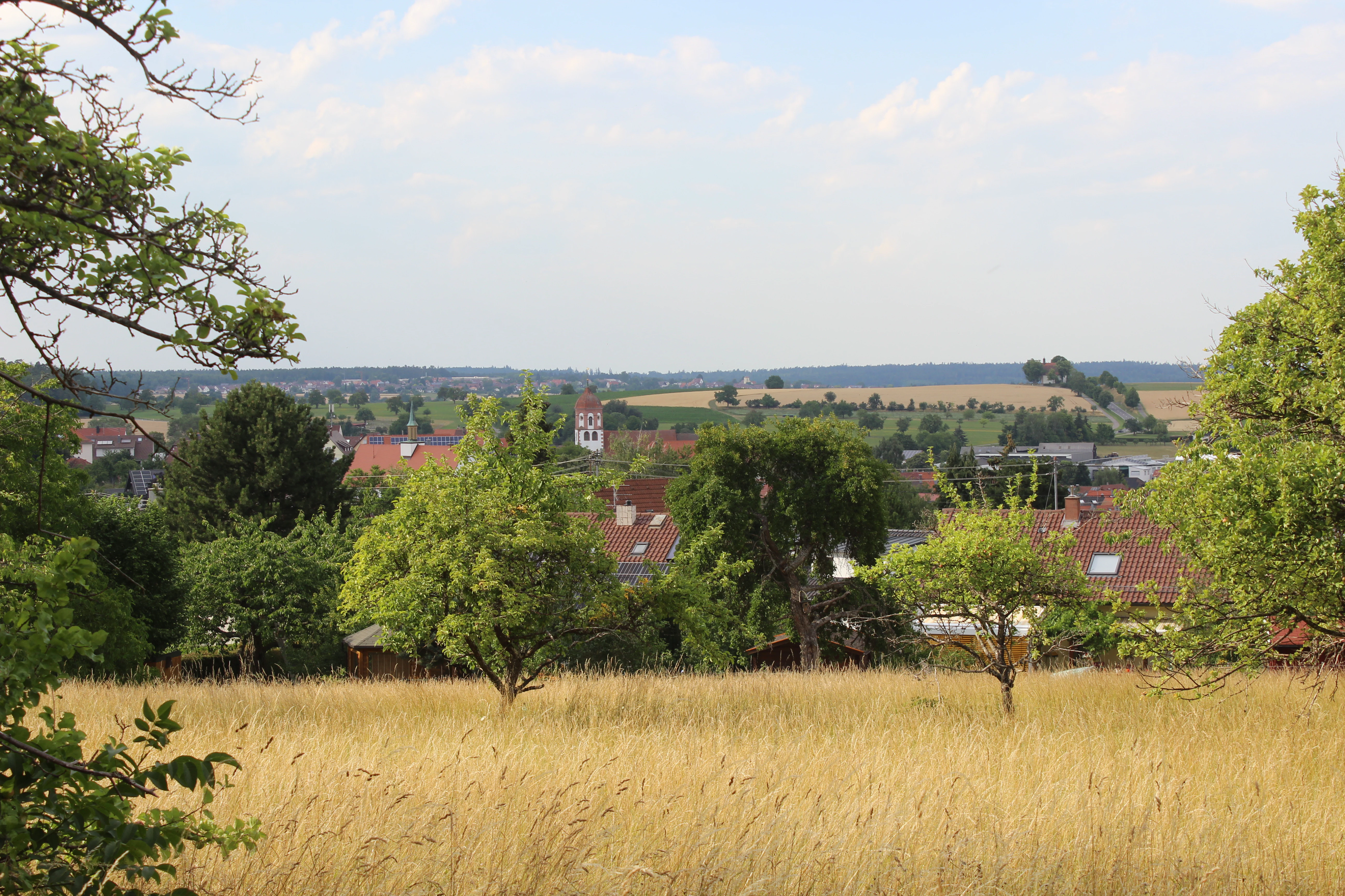
View of Neuhausen from Galgenberg
View of Neuhausen, Enzkreis, with the St. Wendelin Chapel on the right and Hamberg visible on the horizon

Neuhausen-Biet history and protected-area timeline

The protected landscape Neuhausen-Biet is a relatively modern designation in its current form, established by regulation of the Landratsamt Enzkreis on 26 August 2004. Its establishment consolidated earlier, narrower protections into a single landscape-scale framework suited to contemporary conservation thinking.

When the 2004 regulation came into force, two older landscape protection orders were partially superseded in the overlap zone: a 1939 order by the Landratsamt Pforzheim protecting landscape parts along the Würm valley on the municipal lands of Mühlhausen, Steinegg, Tiefenbronn, Hamberg, and Würm, and a 1940 order by the Landratsamt Enzkreis protecting landscape parts in the Monbach valley on Neuhausen municipal land. Where those earlier orders overlapped with Neuhausen-Biet, they ceased to apply, but they remain historically relevant as the preceding protection framework.

The 2004 redesign reflected a shift from isolated valley-by-valley protections to a more holistic, municipality-scale landscape protection approach. It also embedded the area within a broader biotope network concept, explicitly recognizing the Würm valley as a green and recreation corridor and the wider plateau-forest mosaic as part of a large-scale habitat connection.

Neuhausen-Biet landscape and geographic character

The landscape of Neuhausen-Biet is shaped by the meeting of two contrasting natural regions. To the north and east lies the Obere Gäue, a relatively open, gently rolling plateau landscape with agricultural fields, meadows, scattered orchards, and small villages. To the west and south, the Black Forest fringe plateaus, the Schwarzwald-Randplatten, rise in a noticeably more forested, steeper, and more dissected terrain.

The Würm river, which gives the protected zone part of its identity, has cut a valley through this transition. The valley floor is broader and more open, used in part for grazing and as a near-natural green corridor. Side valleys such as the Monbach valley deepen the relief and introduce narrow, more enclosed forest landscapes.

Visually, the area alternates between wide views over agricultural plateau surfaces and tighter, wood-framed views into valley heads and slopes. Wooded ridges, field margins, hedges, and orchard stands create a typical southwestern German Gäu fringe mosaic, often photographed from elevation points such as the Galgenberg viewpoint near Neuhausen itself.

Neuhausen-Biet ecosystems, habitats, and plant life

Ecologically, Neuhausen-Biet functions as a representative example of a southwestern German Gäu fringe landscape with strong transitions to Black Forest ecosystems. The plateau areas carry agricultural vegetation, mesophilic meadows, and orchard structures typical of the upper Gäu, while the valley slopes and side valleys transition to mixed and conifer-rich forest communities more characteristic of the Schwarzwald-Randplatten.

The Würm valley itself provides a near-natural river corridor with associated floodplain vegetation, while smaller tributaries such as the Monbach add shaded, humid forest microhabitats in narrow valleys. These gradients give the protected landscape a notable diversity of habitat types within a small spatial footprint.

Because the area includes part of the FFH site Würm-Nagold-Pforte, its ecological significance is recognized at the European level for selected habitat types and species tied to this transition zone between loess and giau plateaus and forested mountain fringe.

Neuhausen-Biet wildlife and species highlights

Although the source material does not enumerate specific species, Neuhausen-Biet's habitat mosaic suggests meaningful wildlife value: open agricultural and meadow zones support small game, farmland bird communities, and insect diversity, while valley forests and stream corridors offer cover and movement corridors for forest-associated species, including deer and typical Black Forest fringe fauna.

Small portions of the protected area fall within the FFH site Würm-Nagold-Pforte, which is designated at the European level partly because of habitat-dependent species, indicating that the area hosts or contributes to conserving habitat for protected or sensitive fauna. The continuity with neighboring nature reserves (Klebwald, Monbach / Maisgraben / St. Leonhardquelle, Unteres Würmtal) further supports species movement across the broader forest fringe system.

Neuhausen-Biet conservation status and protection priorities

The principal conservation purpose of Neuhausen-Biet, per the 2004 regulation, is to preserve the diversity, character, and beauty of the local landscape, an objective rooted specifically in the contrast between valley floors and high plateaus and in the area's geological variety. The regulation also stresses the high recreational value of this spatially varied landscape.

A second core aim is the conservation and enhancement of the Würm valley as a valuable green and local recreation corridor. In addition, the regulation views the broad open areas of the protected landscape as part of a large-scale biotope network, recognizing that their ecological value lies as much in connectivity as in local habitat quality.

The protected landscape also plays a stabilizing role for what the regulation describes as the largely balanced and ecologically intact natural balance of the area. By overlaying part of the FFH site Würm-Nagold-Pforte and adjoining nature reserves, Neuhausen-Biet functionally reinforces a coordinated habitat protection system spanning municipality, district, federal state, and European levels.

Neuhausen-Biet cultural meaning and human context

Neuhausen-Biet's cultural meaning is closely tied to the long-standing rural and small-settlement character of the municipality of Neuhausen itself. The area includes traditional land use patterns: meadows, pastures, orchards, and managed woodland, all of which form part of the regional Enzkreis identity.

The protected landscape's name partly preserves older local landscape terminology. "Biet" is a regional term historically used in parts of southwestern Germany to describe open land, woodland clearings, or shared common areas around settlements, and its presence in the name reflects the area's role as a shared rural landscape surrounding the village.

Settlements such as Hamberg, Steinegg, and Tiefenbronn, visible from surrounding viewpoints and partly bordering the protected area, anchor this rural landscape identity, while the Würm valley itself has long served as a green axis between villages and a focus of local recreation.

Top sights and standout views in Neuhausen-Biet

The standout strengths of Neuhausen-Biet lie in its compression of multiple landscape types into a small, continuous protected zone, its function as a transition between Gäu plateau and Black Forest fringe, and its integration into a network of adjoining nature reserves and a European-level FFH site.

Its long valley sequences, especially along the Würm and into side valleys like the Monbach, and its patterned mosaic of fields, orchards, and forest blocks make it a visually distinctive and ecologically representative southwestern German protected landscape, well suited for both low-impact outdoor recreation and habitat connectivity.

Best time to visit Neuhausen-Biet

The area is most appealing in late spring and summer, when meadows, orchards, and field margins are in active growth and the Würm valley is at its greenest. These months make the valley-gau-forest contrasts particularly visible and support outdoor use of the protected landscape's recreation corridors.

Autumn is also well suited, with typical Gäu fringe color shifts in orchard and mixed forest stands. In winter, snow cover can visually dramatize the transition between the open plateau and the forested Black Forest fringe, though visitors should rely on general seasonal conditions rather than on-site operational specifics.

Monthly climate preview

Long-term representative point measurements tracking monthly temperature and precipitation rhythms across the protected terrain

Neuhausen-Biet Climate Normals and Annual Weather Patterns

Long-term NASA Power records for a representative coordinate at 338 meters elevation outline the measured annual temperature and precipitation rhythm across Neuhausen-Biet. Reviewing the complete twelve-month climate profile provides deeper context on average temperature ranges and monthly precipitation distribution.
Annual mean9 °C
0 °C20 °C
Jan
Feb
Mar
Apr
May13°
Jun17°
Jul20°
Aug19°
Sep15°
Oct10°
Nov
Dec
Warmest month
July

19.6 °C

Coolest month
January

-0 °C

Wettest month
May

2.7 mm/day

Driest month
April

1.7 mm/day

Park location guide

Geography guide, regional context, and park location map for Neuhausen-Biet

Neuhausen-Biet park geography, regions, and map view in Germany

Understand where Neuhausen-Biet sits in Germany through a broader geographic reading of the surrounding landscape, nearby location context, and its mapped position within the national park landscape.

How Neuhausen-Biet fits into Germany

Germany is a federal republic in Western and Central Europe with a population of over 83 million across sixteen constituent states. It is Europe's largest economy by nominal GDP and a major global exporter and importer. The capital is Berlin, and the country borders Denmark, Poland, Czech Republic, Austria, Switzerland, France, Luxembourg, Belgium, and the Netherlands.

Wider geography shaping Neuhausen-Biet in Germany

Germany is located in Western and Central Europe, spanning 357,022 km². It borders Denmark to the north, Poland and the Czech Republic to the east, Austria and Switzerland to the south, and France, Luxembourg, Belgium, and the Netherlands to the west. The country has coastlines on the Baltic Sea and North Sea to the north, with the Alps located in the southern region.

Map view of Neuhausen-Biet

Use this park location map to pinpoint Neuhausen-Biet in Germany, understand its exact geographic position, and read its mapped placement within the surrounding landscape more clearly.

Pigeon | © OpenStreetMap contributors

Location context for Neuhausen-Biet

Baden-Württemberg

Explore the terrain, scenery, and habitats of the Black Forest fringe

Neuhausen-Biet Photos and Landscapes: Visualizing the Protected Area

Visual records reveal the diverse topography and ecological transition zones defining Neuhausen-Biet. Photographic documentation highlights the distinct character of the Würm river valley, surrounding plateaus, and protected woodlands.

View of Neuhausen from Galgenberg

Panorama of Hamberg, Steinegg, and Tiefenbronn

Park atlas

Compare surrounding regional geography and connected protected landscapes

Parks Near Neuhausen-Biet, Explore Related Protected Areas in the Region

Browsing other protected areas near Neuhausen-Biet reveals how adjacent river valleys and plateau habitats link together across the district. Expanding the geographic comparison provides a clearer picture of the regional biotope network and surrounding terrain.
Protected landscapeBaden-Württemberg
About 13 km away#1 closest

Southeast

Heckengäu-Weil der Stadt Protected Landscape: Mapping the Cultural Scenery of Baden-Württemberg

A regional mosaic of orchard meadows and river valleys

Heckengäu-Weil der Stadt defines a complex protected area composed of fourteen distinct sub-sections circling the town of Weil der Stadt. This geography preserves an intact cultural landscape of small-scale fields, hedgerows, and the Würm river floodplain, standing as a critical transition zone between the Gäu plateau and the rising foothills of the Black Forest.

Area
17.7 km²
Established
1986
IUCN
V
Relief
Upland
Nature reserveBaden-Württemberg
About 13 km away#2 closest

West

Eyach oberhalb Neuenbürg Nature Reserve: Mapped Geography and Protected Area Context

A diverse habitat mosaic in the northern Black Forest highlands

The Eyach oberhalb Neuenbürg nature reserve protects an intricate valley system that cuts through the northern Black Forest. This site is defined by its rich variety of forest, grassland, and rocky habitats clustered across steep hillsides and plateau surfaces. The data highlights the essential land cover and topographical features that sustain this protected area within the Baden-Württemberg regional landscape, offering a precise look at its ecological configuration and physical boundaries.

Area
3.219 km²
Established
2019
Relief
Mountain
Climate
Temperate
Protected landscapeBaden-Württemberg
About 14 km away#3 closest

Northwest

Grafenhausener Kirschengau: Protected Landscape and Regional Geography in Baden-Wurttemberg

Orchard meadows and Arnbach stream valley terrain.

Spanning 137 hectares near Birkenfeld, the Grafenhausener Kirschengau preserves a vital cultural and ecological mosaic in the Kraichgau uplands. This protected landscape combines calcareous grasslands, wooded slopes, and riparian gallery forest, offering a detailed glimpse into the region's traditional land-use history and geological heritage.

Area
1.366 km²
Established
1983
IUCN
V
Relief
Upland
Protected landscapeBaden-Württemberg
About 14 km away#4 closest

East

Weissach Protected Landscape: A Geographic Overview of the Heckengäu Mosaic in Germany

Orchard meadows, dry grasslands, and riparian corridors in Baden-Württemberg

Discover the unique geography of the Weissach protected landscape, a five hundred hectare mosaic of traditional orchards, hedges, and small-scale field systems in the Neckar Basin. This atlas entry details the connectivity of its sub-areas, from the Strudelbach valley to the dry grassland slopes, framing the area as a vital component of the broader regional conservation network.

Area
5.782 km²
Established
1994
IUCN
V
Relief
Upland
Protected landscapeBaden-Württemberg
About 15 km away#5 closest

North

Gengenbachtal und Dolinenlandschaft südlich Göbrichen: Protected Landscape and Karst Geography

Geographic profile of the Enzkreis district in Baden-Württemberg

This protected area captures the contrast between the wooded Gengenbach stream valley and the doline-studded meadows of the Kraichgau. By preserving these distinct meadow and karst habitats, the landscape provides a clear window into the geological transition between the Black Forest and the surrounding plateaus of southwestern Germany.

Area
3.398 km²
Established
1952
IUCN
V
Protected landscapeBaden-Württemberg
About 17 km away#6 closest

Southwest

Teinachtal mit Seitentälern: Protected River Valley Landscape in the Northern Black Forest

Geographic map overview of the Teinach river valley and tributary systems.

The Teinachtal mit Seitentälern protected area serves as a significant conservation zone in the Landkreis Calw. This landscape, integrated with the Naturpark Schwarzwald Mitte and Nord, preserves a richly structured network of stream corridors and forest slopes that connect diverse local habitats.

Area
12.606 km²
Established
2000
IUCN
V
Protected landscapeBaden-Württemberg
About 22 km away#7 closest

East

Wartbiegel - Katharinenlinde und Umgebung: Mapped Protected Landscape and Regional Geography

Traditional orchard mosaic in the Neckar basin, Germany

Discover the geographic structure of Wartbiegel - Katharinenlinde und Umgebung. This protected landscape preserves a unique relief of slopes and agricultural patterns in Baden-Württemberg. The area functions as a vital example of traditional land-use conservation, combining local ecological value with a textured rural landscape near Schwieberdingen.

Area
0.421 km²
Established
1987
IUCN
V
Relief
Upland
Protected landscapeBaden-Württemberg
About 23 km away#8 closest

North

Wössinger Waldwiesen: A Protected Landscape in the Kraichgau Region of Baden-Württemberg

Mapped valley meadows and stream corridor geography

Wössinger Waldwiesen is a compact protected landscape located in the Baden-Württemberg region of Germany. The area provides a significant example of Kraichgau valley geography, blending orchard meadows with the headwaters of the Walzbach stream. This protected territory focuses on maintaining diverse meadow habitats and transitioning former conifer stands into structured, native broadleaf forest ecosystems.

Area
0.056 km²
Established
1988
IUCN
V
Relief
Upland

Common questions about visiting, size, designation, and location context for Neuhausen-Biet

Neuhausen-Biet FAQs for park facts, access, geography, and protected area context

Find quick answers about Neuhausen-Biet, including protected-area facts, park geography, trail and visitor context, and how the park fits into its surrounding country and regional landscape.
MoriAtlas Explorer

Continue Your Protected Areas Search Across the Global Atlas

Deepen your exploration by continuing the structured search for national parks and protected areas worldwide. Utilize the comprehensive filtering capabilities to compare different conservation landscapes and refine your understanding of global park geography. Discover more about the distribution and characteristics of protected natural areas.

Global natural geography