Mori Atlas logo
Wildlife reserveNguru Lake

A critical Sahelian freshwater landscape defined by its endorheic lake and flood pulse.

Nguru Lake Wildlife Reserve: Mapping the Seasonal Wetland Geography of Yobe Nigeria

(Nguru Lake (and Marma Channel) complex)

Nguru Lake represents a core component of the Hadejia-Nguru wetlands in northeastern Nigeria. This protected landscape sits within a low-relief Sahelian environment where seasonal water flows from the Marma Channel drive an expansive flood system. Explore the geographic boundaries and seasonal changes that shape this significant wetland habitat and its surrounding oxbow features.

Sahelian wetlandendorheic lakefreshwater lakeseasonal floodplainmigratory waterbirdswaterfowl sanctuary

Nguru Lake

Wildlife reserve

Park overview

Structured park overview, official facts, and landscape profile for Nguru Lake

Nguru Lake park facts, protected area profile, and essential visitor context

Review the core facts for Nguru Lake, including designation, size, terrain, visitor scale, habitats, and operating context in one park-focused overview.

About Nguru Lake

Nguru Lake is a shallow, seasonally fluctuating lake in the far northern part of Nigeria, near the border with the broader Lake Chad basin. Although the lake is only about 37 square kilometers in its open-water form, it sits within a much larger hydrological and ecological landscape defined by the Komadugu Yobe river system, the Hadejia River, and the network of floodplains and oxbow lakes around them. The lake itself is endorheic, meaning it has no outflow; its water balance is governed almost entirely by seasonal inflow via the Marma Channel, evaporation, and the slow rise and fall of the surrounding floodplain.

The lake's defining role is as the northern anchor of the Hadejia-Nguru wetlands, one of the largest and most ecologically important wetland complexes in the West African Sahel. When seasonal rains swell the Hadejia system, the Marma Channel delivers water into Nguru Lake and onto its floodplain, producing a seasonal inundation area of around 581 square kilometers. These seasonal waters have shaped a landscape of open lake, fringing marshes, oxbow lakes, and wet grasslands that together support a remarkably rich birdlife. The lake and the nearby Dagona oxbow system (Gastu, Maram, and associated oxbows) have been recognized internationally through the Ramsar Convention and form the Dagona Waterfowl Sanctuary, an integral component of Chad Basin National Park.

Ecologically, Nguru Lake is driven by a productive algal base, dominated by green algae (Chlorophyta), cyanobacteria, diatoms, and dinoflagellates, which supports both zooplankton communities and a diverse fish fauna. Up to 24 fish species from 13 genera have been recorded, with cichlids forming the majority of the catch and several other families contributing important shares. This productivity supports a local fishery whose sustainable yields have been documented in scientific surveys of the lake. The lake is therefore both an ecological stronghold and a resource base for surrounding communities.

Beyond its ecological and hydrological importance, Nguru Lake is significant in the regional conservation landscape. It sits inside one of Nigeria's most important protected-area complexes, the Chad Basin National Park system, and is linked through the Hadejia-Nguru wetlands to broader efforts to safeguard Sahelian wetland habitats. Its mix of resident and migratory birdlife, productive fisheries, and dependence on intact seasonal hydrology makes it a key reference site for understanding both Sahelian wetlands and the conservation challenges facing them.

Quick facts and research context for Nguru Lake

Nguru Lake lies in Yobe State in northeastern Nigeria, just south of the town of Nguru in the Sahelian transition zone. It is part of the Hadejia-Nguru wetlands, a recognized Ramsar site and a key component of Chad Basin National Park via the Dagona Waterfowl Sanctuary. The lake covers around 37 square kilometers and sits at approximately 342 meters elevation, with average depths around 2.5 meters and a maximum near 7 meters; it is fed by the Marma Channel and has no natural outflow. The climate is strongly seasonal, with a dry season from November to April and a monsoon-driven wet season peaking from June onward.

Protection and recognition

Documented terrestrial protection scope and Ramsar wetland designation data

Nguru Lake Protection Status and International Recognition Records

Terrestrial protection records for Nguru Lake highlight its official Ramsar wetland designation status and international recognition framework. Conservation database records outline the documented management scope without assuming active ecological outcomes.

International recognition

Protection details

Protection scope
Terrestrial
Transboundary protection
No
Park context

Deeper park guide and search-rich context for Nguru Lake

Nguru Lake history, landscape, wildlife, and travel context

Explore Nguru Lake through its history, landscape character, ecosystems, wildlife, conservation priorities, cultural context, and seasonal travel timing in a structured park guide built for atlas discovery and search intent.

Why Nguru Lake stands out

Nguru Lake is best known as a critical seasonal waterbird habitat within the Hadejia-Nguru wetlands and as a Ramsar-recognized component of the Dagona Waterfowl Sanctuary inside Chad Basin National Park. It is also recognized for its highly productive algal and fish ecology, which supports a substantial local fishery. Together these qualities make the lake a defining ecological anchor in one of West Africa's most important inland wetland complexes.
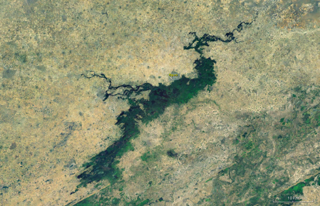
Satellite imagery showing the Hadejia-Nguru wetlands area with the dark blue form of Nguru Lake surrounded by arid landscape.
Satellite view of Nguru Lake in Yobe State, Nigeria.

Nguru Lake history and protected-area timeline

Nguru Lake's significance rose to international attention through its inclusion in the Hadejia-Nguru wetlands, which were designated as a Ramsar site and incorporated into Nigeria's protected-area framework as part of the Dagona Waterfowl Sanctuary within Chad Basin National Park. The wetland complex gained formal recognition as an important staging and wintering area for Palearctic migratory waterbirds. While the lake itself is a long-standing natural feature of the Sahelian landscape, its modern conservation identity is closely tied to the development of Chad Basin National Park as an umbrella for wetlands in northeastern Nigeria.

The lake area has also been the subject of ecological and fisheries research documenting its algal dynamics, fish community, and waterbird populations. These studies have informed assessments of sustainable fishing pressure and of the lake's role as a habitat for migratory and resident species. The broader history of the Hadejia-Nguru system is also shaped by upstream water management and changing rainfall patterns, which have affected seasonal inflows into the lake via the Marma Channel.

Nguru Lake landscape and geographic character

Nguru Lake sits in a low-relief Sahelian landscape at around 342 meters above sea level, characteristic of the flat to gently undulating terrain of northeastern Nigeria. The lake itself is broad and shallow, reaching a maximum depth of only about 7 meters with an average depth close to 2.5 meters, giving it the expansive, shallow profile typical of endorheic Sahelian lakes. There is no significant topographic relief around the lake; instead, the landscape character is shaped by water rather than by mountains or cliffs.

The defining landscape feature is the seasonal flood system associated with the lake. During the wet season, water from the Hadejia River system enters the lake via the Marma Channel, and the lake expands outward across its floodplain, which can reach roughly 581 square kilometers at peak inundation. Around the lake lie the Dagona oxbow lakes, known locally as Dagona Ox-bow Lakes, which are curving, seasonally filled channels cut off from the Marma Channel. Together, the open lake, the fringing floodplain, and the oxbow network form a mosaic of open water, marshland, wet grassland, and seasonally exposed mudflats, shaped entirely by the annual rhythm of flood and drawdown.

Nguru Lake ecosystems, habitats, and plant life

The natural character of Nguru Lake and its surroundings is defined by strongly seasonal wetland dynamics. During the wet season and the months following peak rains, the lake and its floodplain form a broad expanse of shallow freshwater, marshes, and seasonally inundated grasslands. As the dry season progresses, water recedes, exposing mudflats and concentrating birdlife along shrinking shorelines. This annual pulse drives both the lake's productivity and its importance for wildlife.

Ecologically, the lake is dominated by a rich algal community in which green algae (Chlorophyta) form the largest share of biomass, followed by cyanobacteria, diatoms, and dinoflagellates. This algal base underpins a zooplankton community of cladoceans, copepods, rotifers, and protozoans, which in turn supports a diverse fish fauna spanning at least 13 genera. The vegetation surrounding the lake and floodplain includes aquatic and wetland plant communities typical of Sahelian floodplain systems, including stands of reeds, sedges, and seasonally flooded grasses whose extent shifts with the annual flood cycle.

The interplay between water levels, algal productivity, and wetland vegetation makes Nguru Lake a textbook example of a Sahelian seasonal wetland, where ecological processes are tightly synchronized to the annual flood pulse.

Nguru Lake wildlife and species highlights

Wildlife at Nguru Lake is dominated by its avifauna. The lake and its associated floodplain, together with the nearby Dagona oxbow lakes (Gastu, Maram, and related oxbows), support roughly 20,000 waterbirds and serve as an important stopover and wintering site for migratory birds from the northern hemisphere. The seasonal concentration of open water, marshland, and exposed mudflats creates ideal conditions for both resident waterbirds and long-distance migrants, including groups such as ducks, geese, waders, herons, and other typical Sahelian wetland species.

The lake's fish fauna is also significant. Up to 24 fish species from 13 genera have been recorded, with cichlids making up the bulk of the fish community. Other recorded families include Clariidae (air-breathing catfishes), Mormyridae (elephant fishes and relatives), Cyprinidae (carps), Alestidae, Mochokidae (including Synodontis catfishes), and electric catfishes. Notable species documented in the lake include the West African lungfish, Nile perch, African bonytongue, elephantnose fish, African sharptooth catfish, and several tilapia species such as Nile tilapia. Daily fishery yields from the lake have been measured at around 540 kilograms, suggesting a healthy, productive fish community that supports local livelihoods.

Nguru Lake conservation status and protection priorities

Nguru Lake's conservation importance is anchored by its position within the Hadejia-Nguru wetlands, one of the most ecologically valuable wetland complexes in Nigeria and the wider Sahel. The lake and its associated Dagona oxbow system are recognized internationally as a Ramsar site, and they form an integral part of Chad Basin National Park through the Dagona Waterfowl Sanctuary. This layered protection reflects the lake's importance as a habitat for migratory and resident waterbirds, as well as its role in sustaining regional fisheries.

Conservation significance is driven by three main factors: the lake's role as a staging and wintering ground for Palearctic migratory waterbirds; its role in supporting a productive and still-sustainable fishery under documented harvest levels; and its position within a larger Sahelian wetland landscape that is increasingly under pressure from climate variability and upstream water management. The lake's endorheic, monsoon-fed hydrology makes it especially sensitive to changes in rainfall and inflows from the Komadugu Yobe system, meaning its long-term conservation status is closely tied to broader watershed management. Its inclusion in the Ramsar network and within Chad Basin National Park provides an institutional framework for ongoing monitoring and protection.

Nguru Lake cultural meaning and human context

Nguru Lake is closely tied to the town of Nguru and to the broader communities of the Yobe State region, where seasonal fishing in the lake and its floodplain is an important livelihood. The seasonal rhythm of the lake shapes local life, with fishing activity and wetland use peaking during and after the flood season and shifting during the long dry period. The Hadejia-Nguru wetlands more broadly have long-standing significance for communities across northern Nigeria, and the lake's inclusion within the Dagona Waterfowl Sanctuary reflects both ecological and cultural relationships between people and this Sahelian wetland landscape.

Top sights and standout views in Nguru Lake

Nguru Lake's standout qualities are its role as the northern anchor of the Hadejia-Nguru wetlands, its status as a Ramsar-recognized site within Chad Basin National Park via the Dagona Waterfowl Sanctuary, and its capacity to support tens of thousands of waterbirds as both a resident and migratory habitat. Equally distinctive is the lake's shallow, endorheic geography, fed by the Marma Channel, which produces a dramatic annual flood pulse across about 581 square kilometers of floodplain. Beneath this bird-focused identity, the lake's productive algal and fish ecology anchors a substantial inland fishery, making Nguru Lake a rare example of a Sahelian wetland that is simultaneously a high-priority bird site and a working freshwater ecosystem.

Best time to visit Nguru Lake

The character of a visit to Nguru Lake is shaped above all by the seasonal flood cycle. The wet season, from roughly May or June through September or October, brings the West African monsoon and lifts inflows from the Hadejia system via the Marma Channel, expanding the lake and its floodplain. This is when the wetland is at its most expansive and biologically dynamic, with the largest open-water area and the richest mix of aquatic and marshland conditions, though heavy rains and heat can make travel conditions demanding.

The dry season, from November through April, brings lower water levels, exposed mudflats, and concentrations of waterbirds along shrinking shorelines, making it often considered a strong period for observing birdlife, especially migratory species. Temperatures across the year range from about 19 to 45 degrees Celsius, so the cooler dry months offer more comfortable outdoor conditions than the hottest periods. Visitors interested in peak bird numbers typically focus on the dry-season window, while those interested in the wetland at its fullest extent benefit from being present during the late wet season and immediately afterward.
Monthly climate preview

Long-term representative measurements showing monthly temperature and precipitation cycles

Nguru Lake Climate Normals, Annual Temperature and Precipitation Rhythm

Representative coordinates record measured monthly temperature swings and seasonal precipitation shifts across twelve distinct periods. Examining complete monthly climate normals for Nguru Lake provides detailed insight into long-term environmental patterns.
Annual mean28 °C
21 °C34 °C
Jan21°
Feb25°
Mar29°
Apr33°
May34°
Jun32°
Jul29°
Aug27°
Sep28°
Oct28°
Nov25°
Dec22°
Warmest month
May

33.6 °C

Coolest month
January

21.4 °C

Wettest month
August

6.2 mm/day

Driest month
January

0 mm/day

Park location guide

Geography guide, regional context, and park location map for Nguru Lake

Nguru Lake park geography, regions, and map view in Nigeria

Understand where Nguru Lake sits in Nigeria through a broader geographic reading of the surrounding landscape, nearby location context, and its mapped position within the national park landscape.

How Nguru Lake fits into Nigeria

Nigeria is a West African federal republic spanning 923,769 km² between the Sahel and the Gulf of Guinea. It is Africa's most populous nation with over 236 million residents, composed of diverse ethnic groups including Hausa, Yoruba, Igbo, and numerous others. The country operates as a federal presidential republic with 36 states and the Federal Capital Territory, using English as its official language and possessing significant linguistic diversity with over 525 indigenous languages.

Wider geography shaping Nguru Lake in Nigeria

Nigeria occupies West Africa between the Sahel region to the north and the Gulf of Guinea in the Atlantic Ocean to the south. It shares borders with Niger to the north, Chad to the northeast, Cameroon to the east, and Benin to the west. The country covers an area of 923,769 square kilometres.

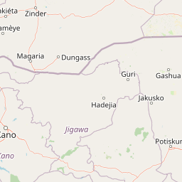
Map view of Nguru Lake

Use this park location map to pinpoint Nguru Lake in Nigeria, understand its exact geographic position, and read its mapped placement within the surrounding landscape more clearly.

Pigeon | © OpenStreetMap contributors

Location context for Nguru Lake

Yobe

Explore national park photography capturing seasonal floodplains and migratory bird habitats.

Nguru Lake Photos and Scenery: Visualizing Sahelian Wetland Landscapes

Visual documentation reveals the expansive shallow waters, seasonal floodplains, and diverse habitats defining Nguru Lake. Examining these protected area images provides deep insight into the unique geography and ecological character of the regional wetland system.

Satellite imagery showing the Hadejia-Nguru wetlands area with the dark blue form of Nguru Lake surrounded by arid landscape.

Park atlas

Discover related wetlands, floodplains, and regional conservation landscapes

Explore Protected Areas and Parks Near Nguru Lake for Regional Comparison

Compare Nguru Lake with other regional protected areas and wetland reserves across the surrounding landscape. Broaden your geographic analysis by examining related habitats and connected ecosystems in the wider basin.
A horizontal watercolor painting depicting a soft green landscape with rolling hills in the background and marshy vegetation in the foreground.
Protected areaZinder
About 138 km away#1 closest

Northwest

Guidimouni Lake Protected Area: Wetland Geography and Zinder Region Landscape Atlas

A Ramsar-designated freshwater and saline wetland system in the Sahel.

Guidimouni Lake is a significant endorheic wetland situated within the Zinder Region of Niger. This protected area consists of a long, narrow depression featuring a rare coexistence of fresh and saline water basins. Beyond its ecological role, the site provides a critical framework for understanding the interplay between Sahelian sand plains, local water-lily habitats, and the regional agro-pastoral economy.

Area
0.6 km²
Established
2019
Relief
Lowland
Climate
Subtropical
Wildlife reserveZinder
About 154 km away#2 closest

Northwest

Mare de Lassouri Wildlife Reserve: Geographic Context and Sahel Wetland Mapping

Protecting vital aquatic habitats in the Zinder Region

Mare de Lassouri serves as a central hub for wetland conservation within the Zinder Region of Niger. This shallow freshwater basin offers a rich habitat mosaic where migratory waterbirds congregate amid bushy savanna, providing essential ecological value and sustaining local agricultural livelihoods in a resource-scarce Sahelian landscape.

Area
7.5 km²
Established
2005
Relief
Lowland
Climate
Arid
National parkNigeria
About 340 km away#3 closest

South

Yankari National Park: A Protected National Park within Nigeria's Geographic Atlas

Explore the mapped terrain and protected landscape of Yankari National Park.

Yankari National Park, designated as a national park within Nigeria, offers a distinct focus for atlas-driven exploration of protected landscapes. This resource provides a detailed perspective on the park's geographic identity, its mapped boundaries, and its significance within Nigeria's wider network of natural areas. Engage with structured information that highlights the park's place in the regional geography and its value as a mapped natural landscape.

A soft, horizontal watercolor painting showing a green and tan landscape of trees and hills with a reflecting body of water in the foreground, set against a white background.
Nature reserveMaradi Region
About 361 km away#4 closest

West

Geschützter Wald von Madarounfa: Protected Woodland and Nature Reserve in the Maradi Region

Mapping the Sahel-Sudan transition landscapes of Niger.

Located in the Maradi Region, this nature reserve protects a rare mosaic of dryland vegetation, including acacia and tamarind groves on alluvial soils. The woodland functions as a critical environmental anchor within the surrounding agricultural plains, offering a window into the natural history of the Goulbi de Maradi river valley.

Area
8.3 km²
Established
1950
Relief
Lowland
Climate
Subtropical
A soft watercolor painting showing a winding river or lake flowing through a landscape with gentle green hills, clusters of trees, and a pale sky.
Nature reserveMaradi Region
About 362 km away#5 closest

West

Madarounfa Lake Nature Reserve: Geographic Overview of Niger's Premier Wetland

Seasonal wetlands and riparian habitats in Maradi Region

Madarounfa Lake functions as a pivotal natural feature in the Maradi Region, blending seasonal hydrological shifts with a distinct cultural identity. This protected area supports critical riparian woodland and waterbird populations, serving as an essential resource for the surrounding landscape. Its classification as a wetland of international importance highlights the environmental complexity of the Sahel-Sudanese transition zone.

Area
8.5 km²
Established
2019
Relief
Lowland
Scope
Terrestrial
Wildlife reserveBorno
About 365 km away#6 closest

East

Lake Chad Game Reserve: A Regional Geography and Wetland Protected Area Profile

Examining the floodplain terrain and hydrological network of Borno, Nigeria.

Lake Chad Game Reserve serves as a primary example of Sahelian wetland ecology, covering vast plains in Borno, Nigeria. The area is characterized by seasonal inundation and a diverse mosaic of swamps, marshes, and river corridors. This profile details the geographic boundaries and distinctive terrain that make the reserve a vital protected landscape within the West African environmental system.

Area
6,073.54 km²
IUCN
IV
Relief
Lowland
Climate
Tropical
National parkNigeria
About 431 km away#7 closest

East

Chad Basin National Park: Exploring Nigeria's Protected Natural Landscape

Mapped protected area and regional geography context.

Chad Basin National Park is a key protected landscape within Nigeria, designated as a national park. This page serves as a gateway to understanding its specific geographic identity, mapped boundaries, and its role within the country's natural terrain. Users can explore detailed information, focusing on the park's atlas-relevant features and its contribution to Nigeria's protected areas, offering a distinct view of the nation's geography.

Area
2,258 km²
Established
1991
IUCN
II
Relief
Lowland
Wildlife reserveNassarawa
About 483 km away#8 closest

South

Pandam Wildlife Park: Geographic Overview and Protected Area Mapping

Wetland and savanna ecosystems of the Bauchi Plateau

Pandam Wildlife Park serves as a centerpiece for wetland conservation in Nigeria, protecting a diverse matrix of seasonal floodplains, savanna woodlands, and gallery forests. This entry provides geographic data on the reserve, focusing on the seasonal connectivity of Pandam Lake and its role in maintaining a rich corridor of biodiversity across the Nassarawa regional boundary.

Area
197.42 km²
Established
1972
Visitors
27K annual
Relief
Lowland

Common questions about visiting, size, designation, and location context for Nguru Lake

Nguru Lake FAQs for park facts, access, geography, and protected area context

Find quick answers about Nguru Lake, including protected-area facts, park geography, trail and visitor context, and how the park fits into its surrounding country and regional landscape.
MoriAtlas Explorer

Continue Your Protected Areas Search Across the Global Atlas

Deepen your exploration by continuing the structured search for national parks and protected areas worldwide. Utilize the comprehensive filtering capabilities to compare different conservation landscapes and refine your understanding of global park geography. Discover more about the distribution and characteristics of protected natural areas.

Global natural geography