Mori Atlas logo
Marine protected areaNimpal Channel Marine Conservation Area

A community-led marine reserve integrating tidal channel dynamics and protected mangrove forests

Nimpal Channel Marine Conservation Area: Mapped Reef and Coastal Protected Landscapes in Yap

Nimpal Channel Marine Conservation Area represents a strategic marine protected area located along the western coast of Yap. This site encompasses a critical reef channel interface and adjacent mangrove forests that act as vital filters for local coastal waters. By mapping the interaction between these terrestrial margins and tidal flow, the reserve provides a structured perspective on regional conservation within the Federated States of Micronesia.

marine conservation areacommunity-based conservationcoral reefmangrove foresttidal channelfish stocks

Nimpal Channel Marine Conservation Area

Marine protected area

Park overview

Structured park overview, official facts, and landscape profile for Nimpal Channel Marine Conservation Area

Nimpal Channel Marine Conservation Area park facts, protected area profile, and essential visitor context

Review the core facts for Nimpal Channel Marine Conservation Area, including designation, size, terrain, visitor scale, habitats, and operating context in one park-focused overview.

About Nimpal Channel Marine Conservation Area

Nimpal Channel Marine Conservation Area is a community-based marine conservation site located along the western shore of Yap, the largest and westernmost of the main islands in Yap State, Federated States of Micronesia. Covering about 77 hectares, it sits along a tidal channel that connects nearshore coral reef habitats with the mangrove systems that fringe parts of the Yap main island coastline. The reserve is small in geographic scale but rich in ecological function, anchoring reef health in a stretch of coast that has long supported traditional fishing and marine resource use.

The site is the product of collaboration between two Yap villages, Okaw and Kaday, which lie within the Weloy municipality, and the Yap Conservation Action Planning initiative. This partnership reflects a broader pattern of community-driven conservation across Yap, where local stewardship is closely tied to customary marine tenure and traditional management of reef and lagoon resources. By placing day-to-day oversight in the hands of neighboring communities, the conservation area combines formal protection with the kind of local knowledge and cultural connection that have shaped Yap's relationship with the sea for generations.

Beyond its original fisheries protection role, the reserve has gained further recognition for its resilience in the face of ecological pressures that have affected reefs across the wider Pacific. Its position within an interconnected coastal system, where mangroves shelter juvenile fish and filter coastal waters, gives it a role that extends well beyond its 77-hectare footprint, contributing to the long-term recovery and stability of Yap's western reef ecosystem.

Quick facts and research context for Nimpal Channel Marine Conservation Area

Nimpal Channel Marine Conservation Area sits on the western coast of Yap, the westernmost main island of Yap State in the Federated States of Micronesia. The site is a community-initiated marine reserve rather than a large-scale national park, covering approximately 77 hectares (190 acres) of reef and channel habitat.

It is cooperatively managed by the villages of Okaw and Kaday within Weloy municipality, working alongside the Yap Conservation Action Planning framework. The reserve's value extends beyond its own boundaries thanks to its connection with adjacent mangrove forests, which together underpin the resilience of Yap's western reef systems.

Protection and recognition

Examine the documented marine protection status and official international recognition records.

Nimpal Channel Marine Conservation Area Protection Status and Formal Recognition Data

Marine conservation status and management scope details define the baseline records for Nimpal Channel Marine Conservation Area. Structured tracking provides access to verified protection metrics and formal international recognition entries without external assumptions.

Protection details

Protection scope
Marine
Transboundary protection
No
Park context

Deeper park guide and search-rich context for Nimpal Channel Marine Conservation Area

Nimpal Channel Marine Conservation Area history, landscape, wildlife, and travel context

Explore Nimpal Channel Marine Conservation Area through its history, landscape character, ecosystems, wildlife, conservation priorities, cultural context, and seasonal travel timing in a structured park guide built for atlas discovery and search intent.

Why Nimpal Channel Marine Conservation Area stands out

Nimpal Channel Marine Conservation Area is best known as a community-led example of marine conservation in Yap, where local villages have taken direct responsibility for managing a reef channel habitat. The site is closely linked with the successful protection of neighboring mangrove forests, which play a central filtration role for the waters flowing through the channel. The area also became notable for surviving the crown-of-thorns starfish outbreak that affected Yap's reefs beginning in 2009, helping to preserve coral cover and the broader reef ecosystem during a period of significant disturbance in the wider Micronesia region.

Nimpal Channel Marine Conservation Area history and protected-area timeline

Nimpal Channel Marine Conservation Area was originally established with the goal of protecting local fish stocks, reflecting longstanding community priorities on Yap around sustaining reef fisheries for village use. From the start, the initiative was a joint effort between the villages of Okaw and Kaday in the Weloy municipality and the Yap Conservation Action Planning program.

A turning point in the reserve's modern history came in 2009, when crown-of-thorns starfish began spreading through Yap's coral reefs. Because predatory outbreaks of this sea star can quickly strip coral tissue and reshape entire reef systems, the appearance of COTS in Yap raised concerns for the long-term health of the island's marine habitats, including those within the Nimpal Channel reserve.

The broader management response that followed, including the decision to formally protect nearby mangrove forests as a sanctuary, marked a significant expansion of the conservation vision around the channel. Recognizing that mangroves filter water flowing into the reef area, this additional protection helped stabilize conditions for recovery and reinforced the ecological case for treating the Nimpal Channel area and its surrounding mangroves as a single connected system.

Nimpal Channel Marine Conservation Area landscape and geographic character

The landscape of Nimpal Channel Marine Conservation Area is defined by the interface between Yap's western coastline and its surrounding Pacific waters. The protected zone centers on a tidal channel that forms part of the coastal reef system along the island's western side, where reef structures meet fringing shoreline habitats. This channel setting creates a dynamic environment shaped by tidal flow, sediment movement, and the daily exchange of water between reef, mangrove, and open ocean.

Neighboring the channel are mangrove forests that line parts of Yap's coast, forming a transitional landscape between land and sea. These mangroves are not just scenery; they are a structural part of the conservation area's ecological landscape, filtering land-derived runoff and providing sheltered margins that influence the health of the downstream reef channel.

Nimpal Channel Marine Conservation Area ecosystems, habitats, and plant life

Ecologically, Nimpal Channel Marine Conservation Area is defined by the relationship between its coral reef channel and the surrounding mangrove forests. The reef channel hosts coral communities and supports the fish populations that originally motivated the reserve's creation, while the mangroves along the coast act as both nursery habitat and a natural filtration system, improving water quality before it reaches the reef.

This connected setup, reef, channel, and mangroves functioning as one system, gives the area a layered ecological character that is more resilient than the individual habitats alone. It also reflects a broader pattern of tropical Pacific coastal ecosystems in which mangroves and reefs are tightly linked through water movement, nutrient cycling, and shared species.

Nimpal Channel Marine Conservation Area wildlife and species highlights

The wildlife profile of Nimpal Channel Marine Conservation Area centers on the reef and mangrove-dependent species typical of Yap's western coast. The channel and its reef structures support reef fish populations that have been the focus of community protection efforts, while the adjacent mangroves provide shelter for juvenile fish and other marine life that move between habitats as they grow.

The site also has a notable story tied to crown-of-thorns starfish, which began affecting Yap's reefs in 2009. The fact that the Nimpal Channel area and its mangroves together held up relatively well during this regional outbreak has been an important signal about the site's ecological value and the role mangrove protection can play in supporting reef resilience.

Nimpal Channel Marine Conservation Area conservation status and protection priorities

Nimpal Channel Marine Conservation Area stands out as a community-based conservation model in Yap, combining village stewardship with broader planning under the Yap Conservation Action Planning framework. Its protection framework is rooted in the desire to maintain healthy fish stocks and has expanded over time to address larger reef health concerns.

The conservation significance of the site was reinforced when crown-of-thorns starfish began impacting Yap's reefs in 2009. The decision to designate the nearby mangroves as a sanctuary, in recognition of their water-filtering role, has been a key conservation outcome, helping to support the recovery of coral reef habitat and showing how protecting one part of a coastal system can strengthen the whole.

Nimpal Channel Marine Conservation Area cultural meaning and human context

The reserve reflects the central role of village communities in managing marine resources on Yap, where traditional stewardship of reef and lagoon areas is deeply woven into everyday life. The collaboration between Okaw and Kaday, two villages within the Weloy municipality, brings a community-led cultural dimension to the conservation effort, anchoring it in local relationships with the sea as much as in formal ecological planning.

Top sights and standout views in Nimpal Channel Marine Conservation Area

Nimpal Channel Marine Conservation Area offers a compact but ecologically rich slice of Yap's western coastline, where a community-managed reef channel sits alongside protected mangrove forests. Its scale is modest, but its role in filtering water, supporting reef recovery after the crown-of-thorns outbreak, and sustaining local fisheries makes it a meaningful node in Yap's wider coastal ecosystem.

The reserve is also notable for what it represents: a village-led conservation partnership that links traditional marine stewardship with structured planning under the Yap Conservation Action Planning initiative, demonstrating how small protected areas can carry substantial conservation weight when paired with strong local engagement.

Best time to visit Nimpal Channel Marine Conservation Area

The character of the Nimpal Channel area, like much of Yap's western coast, is shaped by tropical Pacific climate patterns, with a generally warm and humid environment year-round. Conditions on the reef channel and in the adjacent mangroves tend to be most settled during the drier parts of the regional climate cycle, when seas are typically calmer and underwater visibility for observing reef habitat is often at its best.

Periods of heavier regional rainfall can affect coastal water clarity and accessibility of nearshore areas, while the broader reef environment continues to function through seasonal changes. For visitors interested in understanding the connection between mangroves and reef health, timing a visit when both habitats can be comfortably observed side by side offers the most complete picture of the conservation area's ecological story.

Monthly climate preview

Long-term representative temperature and monthly precipitation averages for Yap

Nimpal Channel Marine Conservation Area Climate Normals and Weather by Month

Historical data records consistent year-round thermal averages alongside shifting monthly precipitation volumes across the representative coordinate. Opening the complete climate profile provides comprehensive monthly breakdowns for deeper analysis of the protected area.
Annual mean28 °C
28 °C29 °C
Jan28°
Feb28°
Mar28°
Apr28°
May28°
Jun28°
Jul28°
Aug28°
Sep28°
Oct28°
Nov29°
Dec28°
Warmest month
November

28.5 °C

Coolest month
February

27.6 °C

Wettest month
August

10.9 mm/day

Driest month
March

3.9 mm/day

Park location guide

Geography guide, regional context, and park location map for Nimpal Channel Marine Conservation Area

Nimpal Channel Marine Conservation Area park geography, regions, and map view in Micronesia

Understand where Nimpal Channel Marine Conservation Area sits in Micronesia through a broader geographic reading of the surrounding landscape, nearby location context, and its mapped position within the national park landscape.

How Nimpal Channel Marine Conservation Area fits into Micronesia

The Federated States of Micronesia (FSM) is a sovereign island nation in the Caroline Islands region of Micronesia, Oceania. Comprising four states spanning nearly 2,700 km across the western Pacific just north of the equator, the federation includes around 607 islands with a land area of approximately 702 km². The capital is Palikir on Pohnpei Island, and the largest city is Weno in Chuuk. The nation achieved independence in 1986 through a Compact of Free Association with the United States.

Wider geography shaping Nimpal Channel Marine Conservation Area in Micronesia

The Federated States of Micronesia lies in the western Pacific Ocean, northeast of Indonesia and Papua New Guinea, south of Guam and the Marianas, west of Nauru and the Marshall Islands, and east of Palau and the Philippines. The four states span a longitudinal distance of almost 2,700 km just north of the equator. Each state is centered on volcanic islands with outlying atolls, situated within the Caroline Islands archipelago.

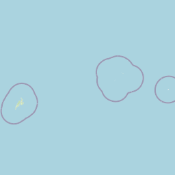
Map view of Nimpal Channel Marine Conservation Area

Use this park location map to pinpoint Nimpal Channel Marine Conservation Area in Micronesia, understand its exact geographic position, and read its mapped placement within the surrounding landscape more clearly.

Pigeon | © OpenStreetMap contributors

Location context for Nimpal Channel Marine Conservation Area

Yap
Park atlas

Compare regional marine reserves and connected coastal conservation zones across the surrounding territory.

Parks Near Nimpal Channel Marine Conservation Area and Related Protected Landscapes

Browsing other protected areas near Nimpal Channel Marine Conservation Area reveals broader regional patterns in coral reef management and tidal channel ecology. Extending the geographic comparison helps travelers and researchers evaluate adjacent coastal sanctuaries and connected marine ecosystems.
Protected areaPalau
About 431 km away#1 closest

Southwest

Ebiil Channel Conservation Area: Geographic Map and Protected Marine Landscape Profile

Coastal conservation mapping in northern Palau

Examine the physical geography and protected maritime boundaries of the Ebiil Channel Conservation Area. This site highlights the coastal transition zones between land and sea in northern Palau, providing essential context for the reef-based topography and marine reserves of the archipelago.

Water
Water-dominated
Marine protected areaNgaraard
About 432 km away#2 closest

Southwest

East Coast Ngaraad Marine Conservation Area: Marine Protected Area and Coastal Map

Northern Babeldaob coastal geography and marine reserve boundaries

Located in Ngaraard State, this marine protected area serves as a significant site for reef conservation and coastal habitat preservation in Palau. The region illustrates the connection between tropical island forest watersheds and reef-fringed lagoons, providing a clear view of the protected coastal environment in northern Babeldaob.

Relief
Lowland
Climate
Tropical
Access
Access unknown
Scope
Marine
Watercolor painting of a calm lake surrounded by lush green hills, with reeds in the foreground and overhanging branches at the top.
Nature reserveMelekeok
About 444 km away#3 closest

Southwest

Lake Ngardok Nature Reserve: Mapped Protected Area and Freshwater Geography in Melekeok

Protected wetland landscapes of central Babeldaob Island

Lake Ngardok serves as a landmark freshwater reserve in Melekeok, featuring extensive marshlands and a connected river drainage system. As a protected watershed on Babeldaob Island, the area offers significant insights into Pacific island freshwater ecology, providing a stable habitat within a dense tropical forest catchment for diverse endemic species and rare wildlife.

Area
4.93 km²
Established
2002
Water
Water-dominated
Nature reserveState of Ngeremlengui
About 455 km away#4 closest

Southwest

Bkulabeluu Conservation Area: Inland Forest Nature Reserve in Ngeremlengui, Palau

Mapped protected landscapes of northern Babeldaob

Deepen your understanding of Bkulabeluu Conservation Area, a significant nature reserve situated in the interior highlands of the State of Ngeremlengui. This atlas entry details the volcanic ridges, tropical rainforest vegetation, and watershed connectivity that define the protected landscape of Babeldaob island, serving as a cornerstone for terrestrial conservation in Palau.

Nature reserveState of Airai
About 458 km away#5 closest

Southwest

Airai State Conservation Area: Protected Forest and Watershed Geography in the State of Airai

Nature reserve on Babeldaob Island, Palau

Located in the State of Airai on Babeldaob Island, this nature reserve protects native forest and watershed headwaters. The area is a key example of state-level terrestrial conservation in Palau, providing essential inland habitat and contributing to the island's overall ecological health through its managed landscape boundaries.

Relief
Lowland
A watercolor painting showing a panoramic view of green islands surrounded by calm, light blue water under a soft pink and yellow sunrise or sunset sky.
Marine protected areaKoror
About 488 km away#6 closest

Southwest

Rock Islands: Protected Marine Landscape and Limestone Archipelago Mapping

Geographic analysis of the reef-derived island system in Koror, Palau.

The Rock Islands consist of hundreds of limestone outcrops scattered across the Southern Lagoon, forming a mosaic of vegetated caps and narrow intertidal notches. This atlas entry provides a structured look at the archipelago's protected boundaries, marine lagoon features, and the unique geology that distinguishes these island landforms in the western Pacific.

Area
41.12 km²
Established
2012
Relief
Lowland
Climate
Tropical
National parkWest Papua
About 1,280 km away#7 closest

South

Teluk Cenderawasih National Park: West Papua's Protected Landscape and Geographic Atlas Entry

Mapped boundaries and regional natural geography.

Delve into the protected area details of Teluk Cenderawasih National Park, situated in the West Papua region. This page serves as a factual entry point for understanding the park's geographic placement and its role as a mapped natural landscape. Examine the park's protected boundaries and how they integrate with the regional geography, providing essential context for atlas exploration.

Area
14,535 km²
Established
2002
IUCN
II
Scope
Mixed
Protected landscapeSurigao del Norte
About 1,322 km away#8 closest

West

Siargao Islands Protected Landscape and Seascape: Geographic Atlas and Park Profile

Protected marine and island landscapes in Surigao del Norte

Spanning Siargao, Bucas Grande, and surrounding islets, this major reserve offers a unique look at the integration of karst-featured terrestrial landscapes with diverse marine zones. Trace the boundaries of a significant Philippine protected area defined by its dense coral reefs, sheltered lagoons, and expansive seagrass meadows supporting rare coastal biodiversity.

Area
2,789.14 km²
Established
1996
Relief
Upland
Climate
Tropical

Common questions about visiting, size, designation, and location context for Nimpal Channel Marine Conservation Area

Nimpal Channel Marine Conservation Area FAQs for park facts, access, geography, and protected area context

Find quick answers about Nimpal Channel Marine Conservation Area, including protected-area facts, park geography, trail and visitor context, and how the park fits into its surrounding country and regional landscape.
MoriAtlas Explorer

Continue Your Protected Areas Search Across the Global Atlas

Deepen your exploration by continuing the structured search for national parks and protected areas worldwide. Utilize the comprehensive filtering capabilities to compare different conservation landscapes and refine your understanding of global park geography. Discover more about the distribution and characteristics of protected natural areas.

Global natural geography