Why Nordre Rønner stands out
Nordre Rønner is best known for its compact combination of three things. First, its position as a small, windswept island group in the Kattegat north of Læsø, shaped by post-glacial land uplift that has fused several islets together into a single linked system. Second, the granite lighthouse Nordre Rønner Fyr on Spirholm, built in 1880 to mark a remote stretch of Danish coastal waters and automated in 1963. Third, and perhaps most importantly from an ecological standpoint, the islands are recognized for their rich coastal bird life and marine mammal presence. They host breeding terns, common eiders, and a sizable population of black guillemots, while Borfeld is known as a breeding site for harbor seals. This combination of cultural maritime heritage and formally protected island habitat gives Nordre Rønner a distinctive profile among Danish protected areas.
Nordre Rønner history and protected-area timeline
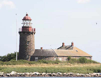
Nordre Rønner's documented history is closely bound up with the construction and operation of its lighthouse. The current Nordre Rønner Fyr was built in 1880 on the main island Spirholm, using granite from the island of Hirsholm. For more than eighty years the lighthouse was a manned station, sustaining a small resident community on Spirholm, where on 1 February 1916 thirteen people were recorded as living, falling to five inhabitants by 1930.
The operational life of the manned station came to an end with the automation of the lighthouse in 1963, after which the keepers and their families departed and the islands became fully uninhabited. The lighthouse tower and associated keeper's dwellings remained on Spirholm as a reminder of this earlier era, though the buildings stood largely unused for several decades.
A new chapter began in 2005, when Læsø Municipality acquired Spirholm along with the lighthouse and its buildings. The goal of the acquisition was to secure public access to the Nordre Rønner area and to renovate the lighthouse complex so that it could once again be presented as it appeared when the islands had a resident community. From 2008, the islands have been managed in cooperation between the volunteer association Nordre Rønners Venner and a steering group that includes representatives from the municipality's environment committee and organizations such as the Danish Outdoor Council. In 2009, EU funding supported the renovation of the lighthouse, which today functions as both a heritage site and a destination for visitors to the islands.
Nordre Rønner landscape and geographic character
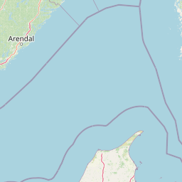
The landscape of Nordre Rønner is defined by its small scale and its sea-dominated setting. The islands cover a combined area of roughly eleven hectares and consist of stony ground, low dunes, and patches of coastal meadow. Their visual character is shaped as much by the surrounding Kattegat as by the land itself, with shallow waters and the connecting sand reef Rønnerev extending south toward Læsø.
Post-glacial land uplift has been a continuous force here, gradually pushing the islands upward and causing several of them to merge over time. The result is a cluster of linked islets rather than a single compact landmass. Spirholm, the largest at around 3.3 hectares, is the central island and carries the lighthouse and its associated built environment. Around it lie smaller formations including Store Stenholm, Lille Stenholm, Langholm, Klatterne, and Borfeld, each with its own subtle variation in elevation and exposure.
The terrain is low and open, with little vertical relief apart from the eighteen-meter lighthouse tower. Vegetation is sparse and coastal in character, dominated by dune grasses and low salt-tolerant plants typical of small Danish sea islands. The atmosphere is dominated by wind, sea, and sky, giving the island group the feel of a remote outpost even though it lies within sight of much larger Læsø to the south.
Nordre Rønner ecosystems, habitats, and plant life
Although tiny in area, Nordre Rønner carries an unusually high ecological weight for its size. The island group lies centrally within the Natura 2000 area known as 'Havet omkring Nordre Rønner', and the surrounding marine and coastal zone is protected under multiple overlapping frameworks. The site is formally designated as a habitat area, a bird protection area, and a Ramsar wetland site, recognizing both the terrestrial habitats of the islands and the marine environment around them.
The islands' habitats are shaped by exposure and by their small size. Stony beaches, low dunes, and coastal meadows form the main vegetation zones, with sparse, salt-tolerant plant communities characteristic of Danish outer-coast islets. The shallow waters around Nordre Rønner and the connecting reef Rønnerev provide feeding and resting conditions for seabirds and support the broader marine ecosystem of the northern Kattegat.
The combination of formal protection, restricted access through its uninhabited status, and its position at the interface between sea and land gives Nordre Rønner a particular ecological character. While the terrestrial area is limited, the protection regime extends well beyond the shoreline, integrating the islands into a wider coastal-marine conservation system.
Nordre Rønner wildlife and species highlights
Nordre Rønner's wildlife profile is dominated by birds and marine mammals rather than terrestrial species, reflecting the strongly coastal character of the island group. The islands are an important breeding site for several species of terns, and they support a notably large population of black guillemots, a seabird species closely associated with rocky and stony coastlines. Rock pipits and common eiders are also part of the regular breeding fauna of the islands.
Marine mammal presence is centered on Borfeld, one of the smaller islands in the group, which holds a breeding population of harbor seals. This makes the broader Nordre Rønner area significant for pinniped life as well as for seabirds. The surrounding waters, including the shallow reef Rønnerev, provide feeding and transit habitat for these animals.
The relative absence of human disturbance, combined with formal protection under the Natura 2000 network and the Ramsar Convention, reinforces the importance of the site for the species that use it. While the inventory is modest in species terms, the breeding populations of terns, guillemots, eiders, and harbor seals give Nordre Rønner a strong and distinctive wildlife identity within the Danish Kattegat.
Nordre Rønner conservation status and protection priorities
Conservation significance is central to Nordre Rønner's modern identity. The islands sit at the core of Natura 2000 site number 20, 'Havet omkring Nordre Rønner', and they have been formally designated under all three key layers of Danish and European nature protection that apply to this kind of coastal-marine area: as a habitat area, as a bird protection area, and as a Ramsar wetland site.
This layered designation reflects the site's value both for breeding seabirds and for marine mammal populations such as the harbor seals of Borfeld, as well as for the broader shallow marine habitat of the northern Kattegat. By combining habitat protection with bird-specific protection and international wetland recognition, Nordre Rønner exemplifies how even very small Danish island groups can qualify for the strongest available nature protection frameworks.
On land, conservation management is reinforced by the islands' uninhabited status and by their ownership under Læsø Municipality. The management partnership with Nordre Rønners Venner and the involvement of bodies such as the Danish Outdoor Council help ensure that public access, heritage preservation, and ecological protection are pursued in a coordinated way.
Nordre Rønner cultural meaning and human context
The cultural context of Nordre Rønner is shaped primarily by its maritime and lighthouse heritage rather than by an inland or agricultural tradition. For over eighty years the islands were home to a working lighthouse community centered on Spirholm, where keepers and their families lived alongside the eighteen-meter granite tower built in 1880. The presence of a measurable resident population in the early twentieth century, including thirteen inhabitants in 1916 and five by 1930, reflects how remote Danish sea islands once sustained small but real communities tied to navigational safety.
The automation of the lighthouse in 1963 marked the end of this way of life on Spirholm and set the stage for the islands' transformation into an uninhabited but publicly recognized site. The renovation of the lighthouse and its associated dwellings, supported by EU funding and the work of the local friends' association, gives the site a renewed cultural role as a heritage destination within the Læsø area.
Top sights and standout views in Nordre Rønner
Nordre Rønner's strongest points of distinction are its compactness and its layered identity. The combination of a tiny, uninhabited island group, a still-standing manned-era granite lighthouse from 1880, and triple formal nature protection status makes the site unusually concentrated in significance. Visitors encounter dunes, stony shores, and open sea within walking distance of an active cultural-heritage restoration project.
Equally notable is the site's ecological density. Breeding terns, black guillemots, rock pipits, and common eiders share the islands with a breeding population of harbor seals on Borfeld, all within a marine area protected as both a Natura 2000 habitat and a Ramsar wetland. Few places of comparable size combine such a depth of protection with such an accessible human story.
Best time to visit Nordre Rønner
Because the islands are uninhabited and exposed, the character of a visit to Nordre Rønner varies noticeably with season. Summer months offer the longest daylight hours and calmer conditions for approaching the islands by boat, and they coincide with the most active period for the breeding seabirds that give the site its ecological significance. Daytime boat access, including the small harbor on the north side of Spirholm, is most practical in this period.
Spring and early autumn bring cooler weather, stronger winds, and less predictable sea conditions, but they can offer quieter visits with fewer other people on the islands. Winter is the least suitable period for general visitation due to short daylight and rougher seas, though the lighthouse complex and its surroundings remain visible from Læsø throughout the year. As in any small Danish sea island, conditions should be checked locally before planning a trip.