
Mori Atlas logo
Protected landscapeÖde im Hartberg

A detailed geographic overview of protected rock outcrops and dry grassland terrain near Bad Urach.

Öde im Hartberg Protected Landscape: Mapping the Limestone Slopes and Juniper Heath of the Swabian Alb

(Landschaftsschutzgebiet Öde im Hartberg)

Öde im Hartberg encompasses a distinctive limestone slope on the Swabian Alb in Baden-Württemberg. This protected landscape is defined by its sun-drenched juniper heathland and the prominent rock heads of Hartbergfels and Seeburger Nägelesfels. Within its ten-hectare footprint, the area functions as a vital link in a regional network of protected sites, including Natura 2000 zones and the UNESCO Biosphärengebiet Schwäbische Alb, representing the natural terrain of the Middle Swabian Alb.

juniper heathlimestone landscapedry grasslandcliff habitatrock outcropsnatural monument
A digital illustration showing a lush green valley with a river and waterfall, framed by stylized trees under a soft sunrise.

Öde im Hartberg

Protected landscape

Park overview

Structured park overview, official facts, and landscape profile for Öde im Hartberg

Öde im Hartberg park facts, protected area profile, and essential visitor context

Review the core facts for Öde im Hartberg, including designation, size, terrain, visitor scale, habitats, and operating context in one park-focused overview.

About Öde im Hartberg

Öde im Hartberg is a compact, ecologically focused protected landscape in the Landkreis Reutlingen, Baden-Württemberg. Although it is small in area, it captures several of the defining landscape elements of the Middle Swabian Alb in a single site: a juniper-dominated dry heath, successional scrub and woodland, and prominent Jurassic limestone cliff features. The protected landscape lies on a south-facing slope of the Hartberg, immediately north of the Seeburg district of Bad Urach, where the Fischburgtal valley opens out toward the town.

The site belongs to the Mittlere Kuppenalb natural region. Geologically, it straddles the boundary between the Upper Massive Limestone and the Lower Massive Limestone of the Upper Jurassic, which is the underlying reason for the dry, sun-exposed character of the slope and for the presence of the rock heads that mark the southern edge of the reserve.

Ecologically, Öde im Hartberg is representative of the traditional Swabian Alb juniper heaths that developed through long-term grazing. Today the heath is partly maintained as open habitat and partly in transition, with shrubs and successional forest gradually reclaiming parts of the slope. The Hartbergfels and Seeburger Nägelesfels are also individually protected as natural monuments, highlighting their geological and visual significance.

Quick facts and research context for Öde im Hartberg

Öde im Hartberg was designated as a protected landscape (Landschaftsschutzgebiet) by the former Landratsamt Münsingen on 31 May 1955 and is now administered under the Landratsamt Reutlingen. It lies on the territory of the town of Bad Urach.

The reserve covers about 10.1 hectares on a south-facing slope of the Hartberg, at the transition between the Upper and Lower Massive Limestone formations of the Upper Jurassic. It belongs to the natural region of the Mittlere Kuppenalb and is bordered to the west by the Fischburgtal protected landscape.

Protection and recognition

Documented conservation records and official protected area baseline metrics

Öde im Hartberg Protection Status and International Recognition Data

Conservation records assemble documented protection status and baseline designation metrics for Öde im Hartberg. Verified database entries track administrative frameworks and official protected area registries without assuming management outcomes.

Protection details

WDPA ID
323441
Park context

Deeper park guide and search-rich context for Öde im Hartberg

Öde im Hartberg history, landscape, wildlife, and travel context

Explore Öde im Hartberg through its history, landscape character, ecosystems, wildlife, conservation priorities, cultural context, and seasonal travel timing in a structured park guide built for atlas discovery and search intent.

Why Öde im Hartberg stands out

Öde im Hartberg is best known for its large, open juniper heath on a sunny limestone slope, a characteristic land use type of the Swabian Alb. The reserve is closely associated with the Hartbergfels and the Seeburger Nägelesfels, two striking rock heads that anchor the southern edge of the site.
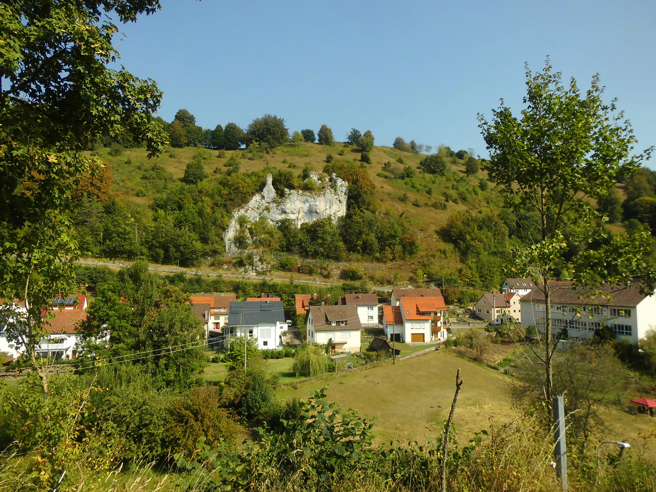
A sunny day view of a light-colored limestone rock cliff emerging from a grassy and wooded hillside, with residential houses of a small village visible at the base of the slope.
The Hartbergfels rock formation rises above the village of Seeburg within the Öde im Hartberg protected area.

Öde im Hartberg history and protected-area timeline

The site was formally protected on 31 May 1955, when the Landratsamt Münsingen issued the ordinance that established Öde im Hartberg as a Landschaftsschutzgebiet. The designation came during a wider wave of landscape protections across the Swabian Alb in the post-war decades, when many traditional grazing landscapes, heaths, and valley features were put under formal protection to prevent further agricultural intensification and loss of open habitat.

Following administrative reforms, oversight of the reserve passed from the former Landratsamt Münsingen to the Landratsamt Reutlingen. In the decades since its designation, the area has also become part of a layered network of higher-level protections. The Hartbergfels and Seeburger Nägelesfels have been recognized as area-based natural monuments, and Öde im Hartberg has been incorporated into the Uracher Talspinne Natura 2000 site, the Mittlere Schwäbische Alb bird protection area, and the care zone of the Biosphärengebiet Schwäbische Alb.

Öde im Hartberg landscape and geographic character

The landscape of Öde im Hartberg is shaped by its setting on a south-facing slope of the Hartberg, just outside Bad Urach. The slope descends from the Hartberg toward the valley of the Fischburgtal, producing a warm, dry microclimate that has historically supported open heathland rather than closed forest. The reserve lies within the Mittlere Kuppenalb, a landscape region defined by rounded hilltops and shallow valleys typical of the Middle Swabian Alb.

The geology of the site is dominated by Upper Jurassic limestone, with the area straddling the boundary between the Upper and Lower Massive Limestone formations. This limestone foundation is responsible for the dry soils and the exposure of bare rock across the slope. In the southern part of the reserve, two prominent rock heads rise above the surrounding heath: the Hartbergfels and the Seeburger Nägelesfels, both individually designated as natural monuments.

Alongside the open terrain, the protected landscape shows a mosaic of juniper shrubs, scrub, and patches of successional woodland. This gives the area a varied, textured appearance and ensures that both open and lightly wooded habitats are represented within its small footprint.

Öde im Hartberg ecosystems, habitats, and plant life

Öde im Hartberg is essentially a dry, calcareous habitat island. Its base ecosystem is a juniper heath on a limestone slope, the type of habitat traditionally maintained by grazing on the Swabian Alb. Such heaths support a distinct community of warmth-loving grasses, herbs, and low shrubs adapted to thin, stony soils and strong sun exposure.

A significant portion of the reserve is in active ecological transition. Where grazing pressure has eased, juniper and herb-rich heath is being colonized by shrubs and young woodland, creating a successional mosaic. This patchwork of open heath, scrub, and developing woodland increases habitat diversity within a very small area, supporting different groups of insects, birds, and small mammals at different stages of vegetation development.

The rocky outcrops at the southern edge add a further ecological dimension. Exposed limestone cliffs and boulder fields provide nesting and roosting sites for cliff-nesting birds and bats, and host specialized plant communities adapted to bare rock and thin rendzina soils.

Öde im Hartberg wildlife and species highlights

While the small size of Öde im Hartberg limits its capacity to host large or wide-ranging fauna, the reserve is ecologically meaningful for species tied to dry limestone heaths and cliff habitats. Its mosaic of open juniper heath, scrub, and successional woodland supports typical Swabian Alb fauna, including insects and reptiles associated with warm, sunny slopes, as well as small mammals and songbirds that use the structural diversity of the vegetation.

The rock faces of the Hartbergfels and Seeburger Nägelesfels provide specialist cliff habitat. These outcrops are valued by nesting and roosting birds, and by bat species that use crevices in the limestone. Their inclusion in Natura 2000 and bird protection area designations reflects their broader regional importance for these groups, even though Öde im Hartberg itself occupies only a small fraction of those larger sites.

Öde im Hartberg conservation status and protection priorities

Öde im Hartberg was established primarily to safeguard a representative example of the traditional juniper heath landscape of the Swabian Alb from further loss and from agricultural or forestry intensification. By formally protecting the open heath, the rock features, and the transition zones of the slope, the 1955 ordinance aimed to maintain both the visual character and the ecological values of the area.

The conservation importance of the site extends well beyond its original designation. It lies within the Uracher Talspinne Natura 2000 site, which protects a network of valleys and slopes around Bad Urach for their habitat and species value at the European level. It is also part of the Mittlere Schwäbische Alb bird protection area and falls inside the care zone (Pflegezone) of the UNESCO Biosphärengebiet Schwäbische Alb, where the focus is on maintaining and developing semi-natural cultural landscapes shaped by long-standing human use.

The Hartbergfels and the Seeburger Nägelesfels are additionally protected as flächenhafte Naturdenkmale, giving the rock features their own independent protection status. Together, these overlapping designations mean that a very small area carries an unusually dense layer of conservation recognition.

Öde im Hartberg cultural meaning and human context

Öde im Hartberg belongs to a long cultural landscape tradition on the Swabian Alb, where juniper heaths developed through centuries of grazing by sheep and other livestock on sun-exposed limestone slopes. The heath is therefore both a natural habitat and a cultural-historical feature, reflecting a regional land-use pattern that has shaped the appearance of the Middle Swabian Alb for generations.

The rock heads of the Hartbergfels and Seeburger Nägelesfels are also part of the local sense of place. As individually protected natural monuments near Bad Urach, they are recognizable landmarks above Seeburg, contributing to the geological identity of the Urach area and connecting the small reserve to the wider cultural landscape of the Swabian Alb.

Top sights and standout views in Öde im Hartberg

The reserve's standout features are its open juniper heath on a warm south-facing slope and the two natural monument rock heads, the Hartbergfels and the Seeburger Nägelesfels, which anchor the site and give it a memorable profile despite its small size.

Its layered conservation status is also a defining quality. Within just a few hectares, the landscape holds a local protected landscape designation, two natural monuments, parts of Natura 2000 and EU bird protection areas, and a place inside the UNESCO Biosphärengebiet Schwäbische Alb, making it a small but intensively protected component of the Middle Swabian Alb.

Best time to visit Öde im Hartberg

The juniper heath and open slopes of Öde im Hartberg are most vivid in late spring and summer, when low-growing herbs, flowering shrubs, and juniper are easiest to observe against the dry limestone ground. In these months the south-facing slope is at its warmest and the rock heads of the Hartbergfels and Seeburger Nägelesfels stand out clearly against the sky. Spring also offers fresh green growth on the heath, while late summer and early autumn bring riper colors and berry-set on shrubs, making the mosaic of heath, scrub, and successional woodland especially visible.

Monthly climate preview

Long-term temperature ranges and monthly precipitation averages for Baden-Württemberg

Öde im Hartberg Climate Normals and Annual Weather Patterns

Historical climate records from 1991 to 2020 outline the measured monthly temperature swings and precipitation rates recorded at representative elevations in Öde im Hartberg. Reviewing the full twelve-month statistical profile provides detailed baseline data for analyzing long-term environmental patterns across the protected terrain.
Annual mean8 °C
-1 °C18 °C
Jan-1°
Feb
Mar
Apr
May13°
Jun16°
Jul18°
Aug18°
Sep14°
Oct
Nov
Dec
Warmest month
July

18.2 °C

Coolest month
January

-1.1 °C

Wettest month
July

3.2 mm/day

Driest month
February

1.7 mm/day

Park location guide

Geography guide, regional context, and park location map for Öde im Hartberg

Öde im Hartberg park geography, regions, and map view in Germany

Understand where Öde im Hartberg sits in Germany through a broader geographic reading of the surrounding landscape, nearby location context, and its mapped position within the national park landscape.

How Öde im Hartberg fits into Germany

Germany is a federal republic in Western and Central Europe with a population of over 83 million across sixteen constituent states. It is Europe's largest economy by nominal GDP and a major global exporter and importer. The capital is Berlin, and the country borders Denmark, Poland, Czech Republic, Austria, Switzerland, France, Luxembourg, Belgium, and the Netherlands.

Wider geography shaping Öde im Hartberg in Germany

Germany is located in Western and Central Europe, spanning 357,022 km². It borders Denmark to the north, Poland and the Czech Republic to the east, Austria and Switzerland to the south, and France, Luxembourg, Belgium, and the Netherlands to the west. The country has coastlines on the Baltic Sea and North Sea to the north, with the Alps located in the southern region.

Map view of Öde im Hartberg

Use this park location map to pinpoint Öde im Hartberg in Germany, understand its exact geographic position, and read its mapped placement within the surrounding landscape more clearly.

Pigeon | © OpenStreetMap contributors

Location context for Öde im Hartberg

Baden-Württemberg

Visualizing limestone outcrops, juniper heath, and varied terrain on the Swabian Alb

Öde im Hartberg Photos and Protected Landscape Scenery

Visual records capture the open juniper heath, striking limestone rock heads, and successional woodland that define the protected landscape of Öde im Hartberg. Examining these terrain views and habitat details provides a clearer understanding of the protected area environment and its distinct regional character.

A sunny day view of a light-colored limestone rock cliff emerging from a grassy and wooded hillside, with residential houses of a small village visible at the base of the slope.

Park atlas

Compare adjacent limestone reserves and regional conservation areas on the Swabian Alb

Explore Parks Near Öde im Hartberg and Surrounding Protected Landscapes

Browse protected areas near Öde im Hartberg to examine similar limestone slopes, juniper heathlands, and regional cliff habitats across the Middle Swabian Alb. Comparing adjacent reserves reveals the broader ecological network and geological patterns defining local conservation zones.
Protected landscapeBaden-Württemberg
About 3.1 km away#1 closest

Northwest

Wolfsschlucht Protected Landscape: Swabian Alb Gorge Geography and Regional Mapping

A key geotope within the central Swabian Alb mountain terrain.

Wolfsschlucht preserves a distinctive limestone gorge and ravine forest system within a compact 1.4 hectare area. Its geography highlights the intersection of karst landforms, steep valley relief, and layered conservation status, serving as a representative model of the central Swabian Alb's geological and ecological character in Baden-Württemberg.

Area
0.014 km²
Established
1955
IUCN
V
A pale, soft-toned watercolor painting depicting a gentle, rolling landscape with green fields, distant hills, and sparse clusters of trees.
Protected landscapeBaden-Württemberg
About 11 km away#2 closest

Northeast

Sommerschafweide hinter dem Hockenden Stein, Auchtweide Protected Landscape and Map

Historic Swabian Alb pasture and geological Kanzel terrain

Discover the geographic layout of Sommerschafweide hinter dem Hockenden Stein, Auchtweide, a protected area in Baden-Württemberg. This site highlights traditional grazed Magerrasen, mature pasture beeches, and the striking geological rock formation known as the Hockender Stein, offering insight into the conservation of the Mittlere Kuppenalb cultural landscape.

Area
0.065 km²
Established
1955
IUCN
V
Relief
Upland
Protected landscapeBaden-Württemberg
About 14 km away#3 closest

Northwest

Neuffen auf Gemarkungen Neuffen und Kappishäusern Protected Area and Regional Landscape

Geography of the Swabian Alb escarpment and riparian zones

This protected landscape defines the visual and ecological character of the area surrounding the Hohenneuffen and Jusi hills. The terrain spans limestone slopes, fruit-bearing orchards, and the Steinach river valley. By integrating local habitat protection with regional biosphere networks, the region serves as a vital transition point between the plateau and the Neckar basin.

Area
13.41 km²
Established
1993
IUCN
V
Relief
Mountain
A pale watercolor landscape illustration showing rolling green hills and meadows under a soft yellow sky.
Protected landscapeBaden-Württemberg
About 16 km away#4 closest

North

Owen Protected Landscape: A Geographic Analysis of Orchard Meadows and Teckberg Terrain

Baden-Württemberg protected area and regional landscape map

Examine the detailed landscape composition of the Owen protected area, a vital reserve in the Mittleres Albvorland. This atlas entry focuses on the interaction between traditional orchard meadow mosaics, hedgerows, and the abrupt topographical shift toward the Teckberg peak, providing a clear geographic context for this protected natural region.

Area
5.67 km²
Established
1974
IUCN
V
Protected landscapeBaden-Württemberg
About 16 km away#5 closest

South

Hinter Gleinsgelesberg Protected Landscape: Swabian Alb Geographic Atlas

Successional forest terrain in Baden-Württemberg

Hinter Gleinsgelesberg is a protected forest patch situated on the karstic plateau of the Swabian Alb in southwestern Germany. Originally used as grazing land, the terrain now exhibits a characteristic transition to closed successional woodland. This site acts as a representative element within the broader network of landscape protection areas located along the Mittlere Flächenalb plateau near Pfronstetten and Hayingen.

Area
0.062 km²
Established
1955
IUCN
V
Relief
Upland
Watercolor illustration of rolling green hills, trees, and wildflowers, with a soft, bright, and light aesthetic.
Protected landscapeBaden-Württemberg
About 17 km away#6 closest

Northeast

Oberes Filstal-Stadt Wiesensteig: Protected Landscape and Regional Geography Mapping

An atlas overview of the Mittlere Kuppenalb landscape mosaic

Covering roughly 171 hectares around Wiesensteig, this protected area serves as a vital component of the central Swabian Alb geography. The site features an undulating karst terrain characterized by a dense forest mosaic, hedgerows, and historic pastoral features. Through its alignment with local Natura 2000 sites, it forms a cohesive ecological bridge between the upper Fils valley and the surrounding high plateau.

Area
1.71 km²
Established
1985
IUCN
V
Relief
Highland
A soft watercolor painting depicting rolling green hills and meadows against a white background.
Protected landscapeBaden-Württemberg
About 17 km away#7 closest

Northeast

Neidlinger Tal Protected Landscape: Regional Geography and Mapped Boundaries

A study of the Swabian Alb and Alb foreland transition terrain

The Neidlinger Tal protected landscape represents a vital intersection of natural regions in Baden-Württemberg. Its boundaries encompass a mosaic of forest and farmland, providing a comprehensive look at how historical land use patterns coexist with modern conservation efforts within the Swabian Alb, including various bird and habitat protection designations.

Area
10.959 km²
Established
1975
IUCN
V
Relief
Upland
Protected landscapeBaden-Württemberg
About 17 km away#8 closest

North

Tiefenbachtal Protected Landscape: Geographic Boundaries and Regional Terrain Map

Swabian Alb foothill mosaic in the Esslingen district

Investigate the protected landscape of Tiefenbachtal, where gently rolling terrain and stream-cut valleys form a continuous ecological corridor. This record covers the physical geography, meadow and woodland composition, and the broader context of this site within the Baden-Württemberg pre-Alb landscape.

Area
0.35 km²
Established
1958
IUCN
V
Relief
Upland

Common questions about visiting, size, designation, and location context for Öde im Hartberg

Öde im Hartberg FAQs for park facts, access, geography, and protected area context

Find quick answers about Öde im Hartberg, including protected-area facts, park geography, trail and visitor context, and how the park fits into its surrounding country and regional landscape.
MoriAtlas Explorer

Continue Your Protected Areas Search Across the Global Atlas

Deepen your exploration by continuing the structured search for national parks and protected areas worldwide. Utilize the comprehensive filtering capabilities to compare different conservation landscapes and refine your understanding of global park geography. Discover more about the distribution and characteristics of protected natural areas.

Global natural geography