Mori Atlas logo
Protected landscapeOsjakowski Zespół Przyrodniczo-Krajobrazowy

Examining the Warta river valley geography and protected floodplain landscape networks.

Osjakowski Zespół Przyrodniczo-Krajobrazowy: A Protected Wetland Corridor in Poland

Osjakowski Zespół Przyrodniczo-Krajobrazowy serves as a critical ecological link within the Lodzkie Voivodeship, connecting larger landscape parks through the natural Warta river valley. This protected area incorporates the Wężnica river mouth, creating an expansive mosaic of floodplain habitats and wetland terrain that support diverse vascular flora and significant breeding bird populations.

river valleyWarta riverwetland habitatswaterbird refugefloodplainprotected landscape

Osjakowski Zespół Przyrodniczo-Krajobrazowy

Protected landscape

Park overview

Structured park overview, official facts, and landscape profile for Osjakowski Zespół Przyrodniczo-Krajobrazowy

Osjakowski Zespół Przyrodniczo-Krajobrazowy park facts, protected area profile, and essential visitor context

Review the core facts for Osjakowski Zespół Przyrodniczo-Krajobrazowy, including designation, size, terrain, visitor scale, habitats, and operating context in one park-focused overview.

About Osjakowski Zespół Przyrodniczo-Krajobrazowy

Osjakowski Zespół Przyrodniczo-Krajobrazowy is a category of Polish landscape and nature protection applied to a river-valley area in central Poland. The complex lies within the Kotlina Szczercowska mesoregion and occupies a strategic position along the Warta river, one of the major lowland rivers of the Polish heartland. Administratively, the protected area stretches across the Siemkowice commune in Pajęczno County and the Konopnica and Osjaków communes in Wieluń County, reflecting how natural river systems often cut across multiple local jurisdictions.

The defining geographical feature of the complex is its position in the landscape: it occupies a stretch of the Warta valley that effectively links two larger protected landscape parks of regional importance. To the west lies the Załęczański Park Krajobrazowy; to the east lies the Park Krajobrazowy Międzyrzecza Warty i Widawki. The Osjakowski complex therefore plays an important connective role, extending the protected character of the Warta valley between these two anchors and enriching the broader corridor with additional habitats, particularly around the mouth of the Wężnica tributary.

From a biodiversity perspective, the area functions as a significant wetland refuge within an otherwise agricultural and forested landscape. Researchers have documented around 230 bird species using the site, of which roughly 145 are breeding species, confirming the complex's role as a waterbird stronghold. The flora is similarly rich: more than 1,000 vascular plant species have been recorded, forming approximately 230 distinct plant communities. This combination of high avian diversity, varied vegetation, and continuous river-valley habitat gives the protected area genuine landscape and ecological value beyond a small local designation.

Quick facts and research context for Osjakowski Zespół Przyrodniczo-Krajobrazowy

Osjakowski Zespół Przyrodniczo-Krajobrazowy is a Polish protected landscape category (zespół przyrodniczo-krajobrazowy) located in the Łódź Voivodeship. It was established in 1998 by regulation of the then Wojewoda of Sieradz and spans communes in both Pajęczno County and Wieluń County. The site covers about 2,492 hectares and falls largely under the management of the Wieluń Forest District, with a small portion administered by the Złoczew Forest District. Its protected subject is a section of the Warta river valley connecting two larger landscape parks.

Protection and recognition

Examine documented terrestrial conservation frameworks and official designation records for Osjakowski Zespół Przyrodniczo-Krajobrazowy.

Osjakowski Zespół Przyrodniczo-Krajobrazowy Protection Status and Regional Scope

Osjakowski Zespół Przyrodniczo-Krajobrazowy maintains structured terrestrial protection status across its defined conservation boundaries. Available designation records outline the foundational management scope and baseline geographic framework without external recognition sources.

Protection details

Protection scope
Terrestrial
Transboundary protection
No
Park context

Deeper park guide and search-rich context for Osjakowski Zespół Przyrodniczo-Krajobrazowy

Osjakowski Zespół Przyrodniczo-Krajobrazowy history, landscape, wildlife, and travel context

Explore Osjakowski Zespół Przyrodniczo-Krajobrazowy through its history, landscape character, ecosystems, wildlife, conservation priorities, cultural context, and seasonal travel timing in a structured park guide built for atlas discovery and search intent.

Why Osjakowski Zespół Przyrodniczo-Krajobrazowy stands out

The protected area is best known for protecting a section of the Warta river valley, including the mouth section of the Wężnica tributary, and for serving as a connecting ecological corridor between the Załęczański Landscape Park and the Międzyrzecza Warty i Widawki Landscape Park. It is also recognized for its value as a refuge for wetland and water-associated birdlife. Surveys have recorded around 230 bird species in the area, with roughly 145 of them breeding locally, reflecting the importance of the floodplain habitats within the broader regional network of protected river landscapes.

Osjakowski Zespół Przyrodniczo-Krajobrazowy history and protected-area timeline

The Osjakowski Zespół Przyrodniczo-Krajobrazowy was formally established in 1998 through a regulation issued on 31 July 1998 by the Wojewoda of Sieradz. At that time, the surrounding region was still organized under the older Sieradz voivodeship structure, before later administrative reforms placed the site within the contemporary Łódź Voivodeship.

The creation of the complex was motivated by the need to protect a representative section of the Warta river valley that was not yet covered by the neighboring landscape parks. By giving protected status to this connecting stretch, including the mouth section of the Wężnica river, the designation effectively extended and consolidated the network of protected river-valley landscapes along this portion of the Warta. Subsequent planning documents, including environmental assessments connected to the Wieluń and Złoczew Forest Districts, have continued to reference the complex as part of the regional conservation framework.

Osjakowski Zespół Przyrodniczo-Krajobrazowy landscape and geographic character

The protected area follows the natural grain of the Warta river valley through the Kotlina Szczercowska, a lowland mesoregion in central Poland. Its terrain is shaped by the river itself rather than by dramatic relief: gentle slopes, floodplain terraces, and wet valley bottomland characterize the local scenery. Because the boundary was drawn to capture the river corridor, the landscape reads as a continuous green ribbon connecting the two larger landscape parks on either side.

A secondary landscape element is the mouth section of the Wężnica, which adds a smaller tributary valley to the broader Warta floodplain and creates additional wetland microhabitats where the two watercourses meet. Most of the protected surface, around 2,485 hectares, lies within the Wieluń Forest District, giving the area a strongly forested character along the dry valley edges, while the wetter valley floor retains its open, marshy character.

Osjakowski Zespół Przyrodniczo-Krajobrazowy ecosystems, habitats, and plant life

Ecologically, the complex is defined by its river-valley habitats and the contrast between forested uplands and wet floodplain. The floodplain supports a mosaic of wet meadows, reedbeds, oxbow-like channels, and marshy pockets typical of lowland Polish rivers. The vascular flora documented on the site is unusually rich: more than 1,000 species of vascular plants have been recorded, organizing themselves into roughly 230 plant communities, indicating a finely varied mosaic of habitats rather than a single uniform environment.

The river itself, together with the lower Wężnica, provides the moisture and disturbance regime that sustains the wetland communities. The surrounding dry-ground forest, managed as part of the Wieluń Forest District, contributes different habitat types and helps connect the wet core with the broader forested landscape of the region.

Osjakowski Zespół Przyrodniczo-Krajobrazowy wildlife and species highlights

The complex is particularly significant for its birdlife, functioning as an important refuge for water-associated and wetland species. Bird surveys have recorded approximately 230 species in total, of which about 145 are breeding locally. This density of breeding waterbirds and wetland-associated species points to the area's importance as a stopover, feeding, and nesting habitat within the regional network of protected river valleys.

Beyond birds, the combination of wet floodplain habitats, riparian forest, and adjoining dry forest creates conditions favorable for a wide range of typical central-Polish lowland fauna. However, the available documentation emphasizes the avifauna most strongly, which aligns with the area's broader recognition as a refuge for waterbirds and wetland species along the Warta.

Osjakowski Zespół Przyrodniczo-Krajobrazowy conservation status and protection priorities

From a conservation standpoint, the complex's main significance lies in its role as a connective protected landscape. By safeguarding the stretch of the Warta valley between the Załęczański Landscape Park and the Międzyrzecza Warty i Widawki Landscape Park, the designation strengthens the integrity of a continuous riverine corridor and limits fragmentation of wetland habitats in the region.

The area also contributes to conservation at the broader landscape level by protecting the mouth section of the Wężnica and by maintaining a diverse wetland-forest mosaic within a largely agricultural and forestry-dominated region. The recorded diversity of breeding waterbird species and the high number of vascular plant communities support the area's recognized ecological value, even though the complex is a smaller-scale designation than the two neighboring landscape parks.

Top sights and standout views in Osjakowski Zespół Przyrodniczo-Krajobrazowy

The standout features of Osjakowski Zespół Przyrodniczo-Krajobrazowy are its position as a connecting stretch of the Warta valley between two larger landscape parks, its rich wetland bird community of roughly 145 breeding species, and its unusually diverse vascular flora of more than 1,000 species.

The inclusion of the mouth of the Wężnica adds a second riverine element to the protected area, broadening the wetland mosaic and reinforcing the corridor function of the complex within the protected landscape network of the Łódź region.

Best time to visit Osjakowski Zespół Przyrodniczo-Krajobrazowy

Because the protected area's character is defined by its river-valley habitats, the most rewarding periods for nature-focused visits are generally spring and early summer, when wetland vegetation is most expressive, waterbird activity along the Warta is at its peak, and the surrounding forest is fully leafed out without yet carrying the dense summer vegetation that obscures views.

Monthly climate preview

Long-term temperature ranges and monthly precipitation averages across the protected landscape

Osjakowski Zespol Przyrodniczo-Krajobrazowy Climate and Annual Weather Patterns

Historical climate records from NASA measurements outline annual temperature swings and monthly precipitation distributions for Osjakowski Zespol Przyrodniczo-Krajobrazowy. Reviewing the complete twelve-month climatology data provides deeper insight into long-term environmental patterns across the protected area.
Annual mean9 °C
-3 °C20 °C
Jan-3°
Feb-1°
Mar
Apr
May14°
Jun18°
Jul20°
Aug20°
Sep15°
Oct
Nov
Dec-1°
Warmest month
July

20.4 °C

Coolest month
January

-2.9 °C

Wettest month
July

2.5 mm/day

Driest month
January

1.3 mm/day

Park location guide

Geography guide, regional context, and park location map for Osjakowski Zespół Przyrodniczo-Krajobrazowy

Osjakowski Zespół Przyrodniczo-Krajobrazowy park geography, regions, and map view in Poland

Understand where Osjakowski Zespół Przyrodniczo-Krajobrazowy sits in Poland through a broader geographic reading of the surrounding landscape, nearby location context, and its mapped position within the national park landscape.

How Osjakowski Zespół Przyrodniczo-Krajobrazowy fits into Poland

Poland, officially the Republic of Poland, is a Central European country spanning from the Baltic Sea in the north to the Carpathian Mountains in the south. It borders Germany, Czech Republic, Slovakia, Ukraine, Belarus, Lithuania, and Kaliningrad Oblast. The country has a temperate climate, diverse landscapes, and is known for its rich history, cultural heritage, and strong economic position within the EU.

Wider geography shaping Osjakowski Zespół Przyrodniczo-Krajobrazowy in Poland

Poland occupies 312,696 km2 in Central Europe, extending from the Baltic Sea coast in the north to the Sudetes and Carpathian Mountains in the south. It borders Germany to the west, Czech Republic and Slovakia to the south, Ukraine and Belarus to the east, and Lithuania and Kaliningrad Oblast to the northeast. The landscape includes lowland plains, uplands, and mountain ranges.

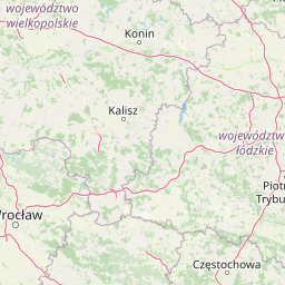
Map view of Osjakowski Zespół Przyrodniczo-Krajobrazowy

Use this park location map to pinpoint Osjakowski Zespół Przyrodniczo-Krajobrazowy in Poland, understand its exact geographic position, and read its mapped placement within the surrounding landscape more clearly.

Pigeon | © OpenStreetMap contributors

Location context for Osjakowski Zespół Przyrodniczo-Krajobrazowy

Lodzkie Voivodeship
Park atlas

Compare adjacent river valley reserves and connected regional conservation areas

Parks Near Osjakowski Zespół Przyrodniczo-Krajobrazowy and Surrounding Protected Landscapes

Browse other protected areas near Osjakowski Zespół Przyrodniczo-Krajobrazowy to compare nearby river corridors and lowland floodplain habitats. Examining adjacent conservation zones provides deeper geographic context for the regional wetland network.
Protected landscapeŁódź Voivodeship
About 5.8 km away#1 closest

South

Załęczański Park Krajobrazowy: Mapping the Karst Landscape and Warta River Geography

A comprehensive look at protected karst features in central Poland.

Spanning the Wieluńska Upland, Załęczański Park Krajobrazowy serves as a central protected landscape renowned for its geological diversity. From the Warta River meanders and oxbow lakes to the concentrated cave systems and pulsating karst springs, this geography provides an in-depth look at the intersection of river dynamics and limestone terrain within the Polish Jura.

Area
147.5 km²
Established
1978
Relief
Upland
Climate
Temperate
Nature reserveLodzkie Voivodeship
About 7.7 km away#2 closest

Southeast

Rezerwat przyrody Mokry Las: Protected Oak-Hornbeam Forest and Regional Geography

A botanical forest refuge in the Kotlina Szczercowska basin.

Situated in the Pajęczno County of central Poland, Rezerwat przyrody Mokry Las is a dedicated nature reserve protecting a complete stand of oak-hornbeam forest. The area stands as an island of mixed deciduous and coniferous woodland within the gentle terrain of the Kotlina Szczercowska, offering a clear view of regional botanical conservation and forest ecology.

Area
0.146 km²
Established
1983
Relief
Lowland
Climate
Temperate
Nature reserveŁódź Voivodeship
About 12 km away#3 closest

South

Dąbrowa w Niżankowicach Nature Reserve: Protected Forest Landscapes and Regional Geography

A vital oak forest sanctuary in Poland's Łódź Voivodeship.

Dąbrowa w Niżankowicach preserves a mosaic of acidophilous oak woodlands and rare flora within the Łódź Voivodeship. This nature reserve functions as a concentrated site for vegetation-focused conservation, maintaining natural forest structures that have become increasingly scarce throughout the wider Wyżyna Wieluńska landscape. Its mapped boundaries highlight a significant ecological island within a predominantly agricultural region.

Area
1.025 km²
Established
1983
Relief
Upland
Climate
Temperate
A watercolor painting of a green, tree-covered hillside set against a pale background.
Nature reserveSilesian Voivodeship
About 36 km away#4 closest

South

Modrzewiowa Góra Nature Reserve: Protected Forest Geography in Silesian Voivodeship

Veteran larch and oak woodland on the Wieluńska Upland

Modrzewiowa Góra functions as a critical nature reserve containing hundreds of mature Polish larch and ancient oaks. Representing a significant ecological fragment in southern Poland, the site maintains natural woodland structure that contrasts with the surrounding agricultural land. This map and geographic record explores the reserve's unique status as a botanical archive within the broader context of the Silesian Voivodeship's natural terrain.

Area
0.493 km²
Established
1957
Relief
Upland
Climate
Temperate
A minimalist watercolor painting showing stylized evergreen trees, rolling hills, and distant mountains in soft green, pink, and yellow tones against a white background.
Nature reserveLodz Voivodeship
About 38 km away#5 closest

Northeast

Rezerwat przyrody Jodły Łaskie im. Stanisława Kostki Wisińskiego Protected Area Atlas

Mapping forest ecosystems and glacial geography in Lodz Voivodeship.

The Rezerwat przyrody Jodły Łaskie im. Stanisława Kostki Wisińskiego serves as a key reference point for central European lowland forest conservation. This nature reserve protects a rare silver fir stand along with mature oaks and pines, showcasing a complex mosaic of forest community types across its uniquely varied glacial lowland terrain.

Area
0.584 km²
Established
1991
Relief
Lowland
Scope
Terrestrial
Nature reserveŁódź Voivodeship
About 41 km away#6 closest

Northwest

Długosz Królewski w Węglewicach Nature Reserve: Mapped Protected Landscapes in Poland

A focused floristic sanctuary in the Łódź Voivodeship.

Długosz Królewski w Węglewicach is a small but ecologically significant nature reserve in the Łódź Voivodeship. Primarily designated to protect royal fern habitats, the reserve showcases a diverse transition of forest types and wetland conditions, offering a clear window into the rare botanical geography of the Kotlina Grabowska region.

Area
0.033 km²
Established
1965
Relief
Lowland
Scope
Terrestrial
A watercolor painting showing a soft landscape with green fields, a cluster of trees, and a small lookout tower against a plain white background.
Nature reserveŚląskie
About 43 km away#7 closest

South

Dębowa Góra Nature Reserve: Geographic Profile of an Urban-Adjacent Protected Forest

Preserving ancient mixed woodland in the Śląskie Voivodeship

Located in the town of Kłobuck, Dębowa Góra serves as a critical nature reserve shielding a fragmented but authentic relic of old-growth oak and hornbeam forest. The site occupies the elevated topography of the Wieluńska Upland, providing an important contrast to the surrounding industrial landscape through its ancient trees and protected understory vegetation.

Area
0.054 km²
Established
1953
Relief
Upland
Climate
Temperate
A soft watercolor painting of a wide, rolling landscape with green hills, patches of trees, and subtle pink ground tones.
Protected areaPoland
About 57 km away#8 closest

Southeast

Przełom Warty koło Mstowa: Mapping the Protected River Corridor and Limestone Geography

A critical geological breakthrough in the Częstochowa Upland.

This protected area features a twelve kilometer river gorge carved by the Warta. The terrain is characterized by dramatic limestone outcrops such as the Brama Mirowska, paired with rich meadow habitats and oak hornbeam forests. Explore the intersection of geology and conservation within this key corridor of the Polish Jura, where river dynamics meet ancient upland landscapes.

Relief
Upland
Climate
Temperate
Scope
Terrestrial
Water
Major water bodies

Common questions about visiting, size, designation, and location context for Osjakowski Zespół Przyrodniczo-Krajobrazowy

Osjakowski Zespół Przyrodniczo-Krajobrazowy FAQs for park facts, access, geography, and protected area context

Find quick answers about Osjakowski Zespół Przyrodniczo-Krajobrazowy, including protected-area facts, park geography, trail and visitor context, and how the park fits into its surrounding country and regional landscape.
MoriAtlas Explorer

Continue Your Protected Areas Search Across the Global Atlas

Deepen your exploration by continuing the structured search for national parks and protected areas worldwide. Utilize the comprehensive filtering capabilities to compare different conservation landscapes and refine your understanding of global park geography. Discover more about the distribution and characteristics of protected natural areas.

Global natural geography