
Mori Atlas logo
Protected landscapeÖstliches Hexental

Mapping the mosaic of riparian forests, traditional orchard meadows, and woodland corridors

Östliches Hexental Protected Landscape and Regional Geography within Baden-Württemberg, Germany

(Landschaftsschutzgebiet „Östliches Hexental“)

Östliches Hexental serves as a primary protected landscape located in the Breisgau-Hochschwarzwald district of southwestern Germany. This area features an intricate geographical mosaic where near-natural stream corridors meet steep forest gradients and open meadow systems. Situated at the ecological transition between the High Black Forest and the Markgräfler Hügelland, the region preserves a distinct cultural landscape that bridges highland terrain and rolling hill country.

landscape protection areaBlack Forestvalley landscapemixed woodlandorchard meadowsriparian gallery forest
Stylized vector illustration of a river valley with terraced green fields, forests, and purple mountains under a pink sunset sky

Östliches Hexental

Protected landscape

Park overview

Structured park overview, official facts, and landscape profile for Östliches Hexental

Östliches Hexental park facts, protected area profile, and essential visitor context

Review the core facts for Östliches Hexental, including designation, size, terrain, visitor scale, habitats, and operating context in one park-focused overview.

About Östliches Hexental

Östliches Hexental preserves the eastern section of the Hexental valley, one of the characteristic transverse valleys on the western margin of the Southern Black Forest. The protected area sits between the Schönberg massif and the southern High Black Forest ridge, in a transitional zone where the steep wooded slopes of the Schwarzwald meet the rolling agricultural hill country of the Markgräfler Hügelland.

Ecologically and visually, the protected area is anchored by its mosaic structure. Woodlands and meadow areas alternate across the valley, while near-natural streams with their gallery forests (Auwald) cut through the landscape. Traditional orchard meadows (Obstbaumwiesen or Streuobstwiesen) and small field hedges (Feldgehölze / Feldhecken) provide additional layers of structural diversity. This combination produces a richly textured habitat mosaic that supports a wide range of plant and animal species typical of southern German mid-mountain landscapes.

The area falls within two major natural regions: 155-Hochschwarzwald (the High Black Forest) and 201-Markgräfler Hügelland (the Markgräfler hill country), which together span the larger natural region units 15-Schwarzwald and 20-Südliches Oberrheintiefland. A small part of the protected landscape also overlaps with the FFH area Nr. 8012-342 Schönberg mit Schwarzwaldhängen, linking it to the European Natura 2000 network.

Administratively, Östliches Hexental is also part of the Naturpark Südschwarzwald, placing it in a broader regional framework of nature-based recreation and landscape conservation. The protected landscape was legally established by ordinance of the Landratsamt Breisgau-Hochschwarzwald on 18 January 2008, and is registered in conservation databases with the WDPA identifier 390331 and the German federal identifier 3.15.045.

Quick facts and research context for Östliches Hexental

Östliches Hexental is a designated landscape protection area (Landschaftsschutzgebiet, IUCN Category V) located in Breisgau-Hochschwarzwald, Baden-Württemberg, southwestern Germany. The protected area covers approximately 526 hectares and spans the municipalities of Au, Sölden, and Wittnau, situated east of the Schönberg mountain and on the edge of the southern High Black Forest. It lies within both the Naturpark Südschwarzwald and partly within the FFH (Flora-Fauna-Habitat) site Nr. 8012-342 Schönberg mit Schwarzwaldhängen. The area was officially designated on 18 January 2008 under ordinance of the Landratsamt Breisgau-Hochschwarzwald.

Protection and recognition

Examine documented protection records and official conservation designations

Protection Status and International Recognition Data for Östliches Hexental

Examine the verified protection status and management scope recorded for Östliches Hexental within official conservation databases. Review structured registry entries to understand the designated framework governing this protected natural landscape.

Protection details

WDPA ID
390331
Park context

Deeper park guide and search-rich context for Östliches Hexental

Östliches Hexental history, landscape, wildlife, and travel context

Explore Östliches Hexental through its history, landscape character, ecosystems, wildlife, conservation priorities, cultural context, and seasonal travel timing in a structured park guide built for atlas discovery and search intent.

Why Östliches Hexental stands out

Östliches Hexental is best known for the classic Black Forest valley mosaic of mixed woodland, extensively used meadows, riparian gallery forests, orchard meadows, and field hedges laced together by near-natural stream courses. The protected area preserves a quintessential southern Black Forest cultural landscape in a relatively compact and accessible setting just east of Freiburg, where the High Black Forest drops toward the Markgräfler Hügelland.
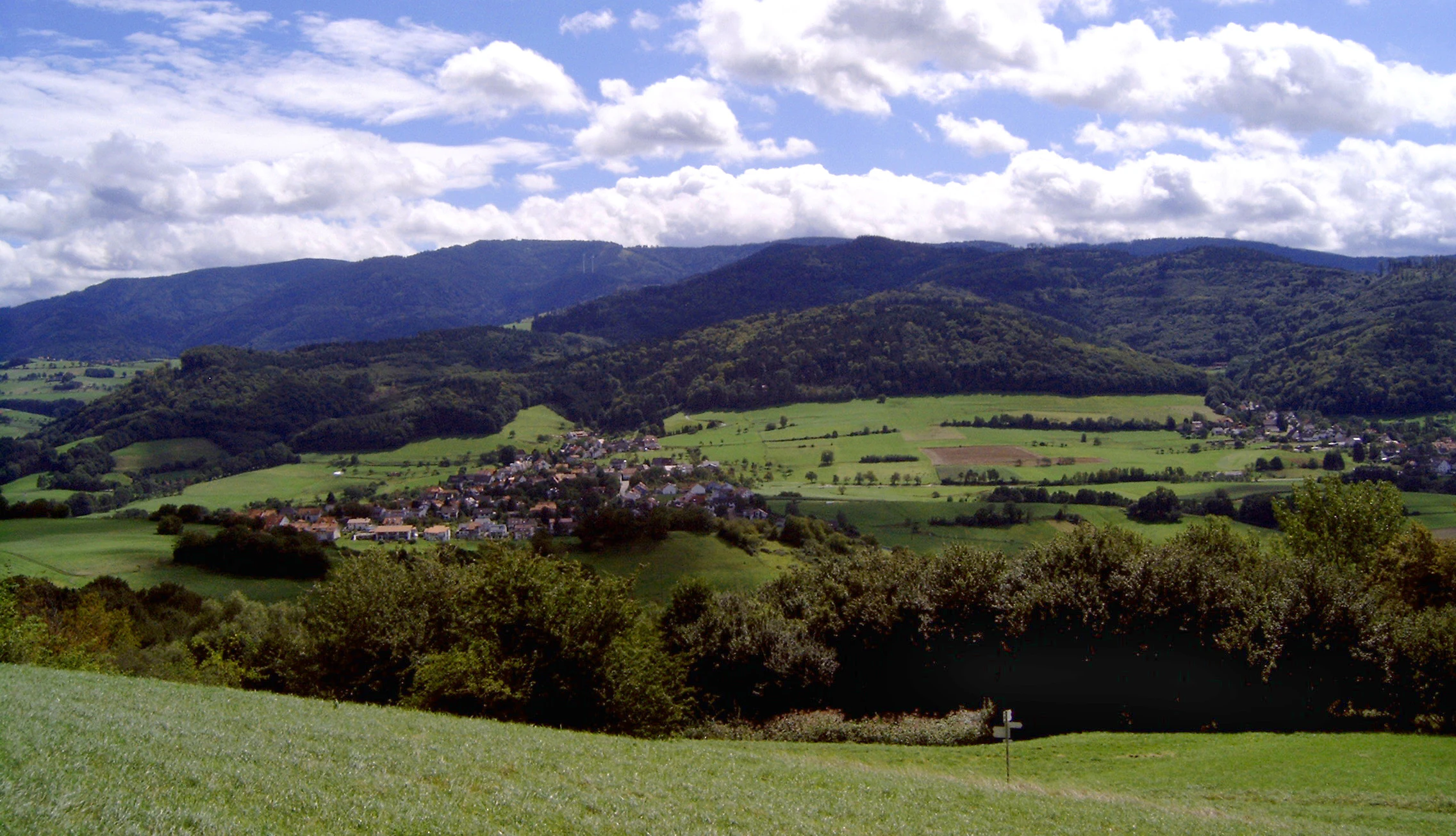
A wide landscape photograph of a green valley with a small village, surrounded by forests and rolling hills, with a large forested mountain in the background under a blue sky with white clouds.
A wide landscape view of the Hexental valley featuring the village of Wittnau, green meadows, and the forested Schauinsland mountain in the background.

Östliches Hexental history and protected-area timeline

The Östliches Hexental landscape protection area was formally established on 18 January 2008 through a protective ordinance issued by the Landratsamt Breisgau-Hochschwarzwald. The designation formalized protection for approximately 526 hectares of the eastern Hexental valley between the Schönberg massif and the southern High Black Forest ridge, an area already embedded in the Naturpark Südschwarzwald and partially overlapping with the FFH-Gebiet Schönberg mit Schwarzwaldhängen.

The valley itself, however, has a long history of human shaping. The mosaic of woodland, meadow, orchard, and stream corridor reflects generations of traditional Black Forest land use, including pasture, hay production, fruit cultivation, and small-scale forestry. The protection ordinance recognized the value of preserving this historically developed cultural landscape, rather than introducing the area as newly wild terrain.

Östliches Hexental landscape and geographic character

The landscape of Östliches Hexental is shaped by the contrast between forested high ground and open valley floor. On the valley sides, the slopes of the Schönberg and the southern High Black Forest drop down in typically steep, wooded gradients, while the valley itself opens into a gentler corridor of meadow, orchard, and stream.

Near-natural stream courses thread through the valley, their banks lined with riparian gallery forest that softens the transition between watercourse and meadow. Beyond these wooded edges, hillside meadows alternate with closed woodland, broken up by small field hedges and the structural punctuation of orchard trees. The result is a varied, visually layered valley landscape, set in the transitional zone between the High Black Forest and the warmer, hillier Markgräfler Hügelland to the west.

Östliches Hexental ecosystems, habitats, and plant life

Östliches Hexental protects a representative cross-section of southern Black Forest valley ecosystems. The central ecological theme is habitat diversity created by the alternation of forest and open land, and by the presence of well-developed riparian corridors.

Near-natural streams with their accompanying gallery forests form the connective tissue of the protected area, while orchard meadows, field hedges, and meadows create additional habitat structures that rare and characteristic species depend on. Part of the protected landscape lies within the FFH-Gebiet Schönberg mit Schwarzwaldhängen, reinforcing its status within the European Natura 2000 network and making the area ecologically relevant beyond the regional scale.

Östliches Hexental wildlife and species highlights

The forest-meadow-stream mosaic of Östliches Hexental provides habitat for a broad range of animals typical of southern Black Forest valley landscapes. The riparian gallery forests along the near-natural streams, the orchard meadows, and the small field hedges offer shelter and feeding grounds for species that depend on this kind of structurally diverse, semi-open landscape. The overlap with the FFH-Gebiet Schönberg mit Schwarzwaldhängen underscores the area's significance for protected fauna within the Natura 2000 framework.

Östliches Hexental conservation status and protection priorities

The core conservation purpose of Östliches Hexental, as set out in its 2008 protection ordinance, is to preserve nature and landscape in the eastern part of the Hexental between the foothills of the Schönberg and the southern ridge of the Black Forest. Particular emphasis is placed on maintaining the characteristic alternation of woodland and extensive meadow areas, the near-natural stream courses with their riparian gallery forests, and the traditional orchard meadows and field hedges that give the landscape its distinctive mosaic character.

Beyond safeguarding habitat, the designation recognizes the area's importance as a recreation landscape of special beauty and character, and its high landscape-aesthetic value for the general public. The protected area is part of the Naturpark Südschwarzwald, and a portion lies within the FFH-Gebiet Schönberg mit Schwarzwaldhängen, linking it to the European Natura 2000 network. Registered internationally as IUCN Category V (Protected Landscape/Seascape) under WDPA ID 390331, Östliches Hexental fits squarely within the protected landscape approach that combines ecological preservation with continued traditional land use.

Östliches Hexental cultural meaning and human context

The landscape of Östliches Hexental is a working cultural landscape shaped by generations of Black Forest valley land use. Orchards, hay meadows, pastures, small field hedges, and managed woodland together form the visible imprint of this rural heritage. The conservation ordinance explicitly values the area's aesthetic and traditional character, framing protection as much about preserving this cultural-landscape identity as about safeguarding natural habitats.

Top sights and standout views in Östliches Hexental

The most distinctive features of Östliches Hexental are the near-natural stream corridors with their riparian gallery forests, the alternating woodland and meadow mosaic, and the traditional orchard meadows and field hedges that structure the valley floor. Its position at the transition between the High Black Forest and the Markgräfler Hügelland gives it layered ecological and scenic value, and its partial overlap with the FFH-Gebiet Schönberg mit Schwarzwaldhängen and full inclusion in the Naturpark Südschwarzwald place it within a connected framework of regional and European nature conservation.

Best time to visit Östliches Hexental

As a low- to mid-elevation valley landscape in the western Black Forest, Östliches Hexental is accessible year-round, though spring and early summer offer the freshest expression of its meadow-and-orchard mosaic, while late spring and early summer highlight orchard blossom and meadow flowers. Autumn brings color to the mixed woodlands along the valley slopes. Winter conditions in this part of the Black Forest are generally milder than in the higher ranges, though snow can still settle on the surrounding forested slopes.

Monthly climate preview

Long term temperature and monthly precipitation patterns across a representative coordinate

Östliches Hexental Climate Normals and Annual Temperature Rhythm

Measured long term temperature values trace an annual thermal cycle alongside consistent daily precipitation records across the protected terrain. Analyzing monthly weather variations provides deeper climate context for the protected area and its surrounding regional geography.
Annual mean8 °C
-2 °C17 °C
Jan-2°
Feb-1°
Mar
Apr
May12°
Jun15°
Jul17°
Aug17°
Sep12°
Oct
Nov
Dec-1°
Warmest month
July

16.8 °C

Coolest month
January

-1.5 °C

Wettest month
May

4 mm/day

Driest month
April

2.6 mm/day

Park location guide

Geography guide, regional context, and park location map for Östliches Hexental

Östliches Hexental park geography, regions, and map view in Germany

Understand where Östliches Hexental sits in Germany through a broader geographic reading of the surrounding landscape, nearby location context, and its mapped position within the national park landscape.

How Östliches Hexental fits into Germany

Germany is a federal republic in Western and Central Europe with a population of over 83 million across sixteen constituent states. It is Europe's largest economy by nominal GDP and a major global exporter and importer. The capital is Berlin, and the country borders Denmark, Poland, Czech Republic, Austria, Switzerland, France, Luxembourg, Belgium, and the Netherlands.

Wider geography shaping Östliches Hexental in Germany

Germany is located in Western and Central Europe, spanning 357,022 km². It borders Denmark to the north, Poland and the Czech Republic to the east, Austria and Switzerland to the south, and France, Luxembourg, Belgium, and the Netherlands to the west. The country has coastlines on the Baltic Sea and North Sea to the north, with the Alps located in the southern region.

Map view of Östliches Hexental

Use this park location map to pinpoint Östliches Hexental in Germany, understand its exact geographic position, and read its mapped placement within the surrounding landscape more clearly.

Pigeon | © OpenStreetMap contributors

Location context for Östliches Hexental

Baden-Württemberg

Visual reference guide to protected valley habitats and terrain

Östliches Hexental Photos and Mapped Landscape Scenery

Photographic records reveal the characteristic mosaic of mixed woodlands, riparian gallery forests, and open meadows across the valley floor. Visual documentation provides clear insight into the protected landscape character and environmental transitions of the southern Black Forest.

A wide landscape photograph of a green valley with a small village, surrounded by forests and rolling hills, with a large forested mountain in the background under a blue sky with white clouds.

Park atlas

Compare adjacent Black Forest valley habitats and regional conservation areas

Parks Near Östliches Hexental and Surrounding Protected Landscape Exploration

Browse protected areas and natural reserves located near Östliches Hexental in southwestern Germany. Compare adjacent valley landscapes, forested slopes, and regional park boundaries to deepen geographic exploration.
A soft watercolor illustration of rolling hills, forested slopes, and meadow vegetation with a light, airy aesthetic.
Nature reserveBaden-Württemberg
About 9.5 km away#1 closest

South

Belchen Nature Reserve: Exploring the Mountain Geography of the High Black Forest

A diverse protected landscape in Baden-Württemberg

Belchen represents an essential protected area in the southern Black Forest, known for its compressed ecological profile ranging from lowland beech forests to exposed subalpine summits. The site maps a complex mosaic of scree slopes, mires, and rocky habitats that sustain specialized bat species and rare montane flora, offering a detailed perspective on central European highland ecosystems.

Area
29.072 km²
Established
2019
Relief
Mountain
Climate
Temperate
Protected landscapeBaden-Württemberg
About 16 km away#2 closest

East

Wagensteigtal-Höllental Protected Landscape: Geography and Terrain of the Black Forest

A bridge between regional natural zones in Baden-Württemberg

Wagensteigtal-Höllental serves as a quintessential example of protected Black Forest geography. Stretching across the Breisgau-Hochschwarzwald district, this area features the steep Rotbach gorge, dense forest ridges, and the prominent Hirschsprung rock formation. It provides a foundational look at how historical transport corridors and natural river breakthrough channels shape the modern landscape identity of southwestern Germany.

Area
29.118 km²
Established
1975
IUCN
V
Relief
Mountain
A watercolor painting showing a panoramic view of rolling golden hills, a line of green trees, and soft purple mountain silhouettes in the distance.
Protected landscapeBaden-Württemberg
About 19 km away#3 closest

Northeast

St. Peter, St. Märgen Protected Landscape: Geography and Regional Context in the Black Forest

Detailed atlas view of the High Black Forest plateau and valleys.

This protected landscape in Baden-Württemberg represents a classic cultural geography of the High Black Forest. It encompasses a vast area surrounding the villages of St. Peter and St. Märgen, where the terrain shifts between steep-sided valleys and elevated plateaus. The protected status secures a varied mosaic of meadows, old-growth hedgerows, and forest tracts that maintain the regional ecological integrity of this significant southwestern German landscape.

Area
67.199 km²
Established
2003
IUCN
V
Nature reserveGrand Est
About 23 km away#4 closest

West

Réserve naturelle régionale de la forêt de Mequillet Le Hardtwald Geographic Atlas and Map

Protected dry forest and steppe habitat in Grand Est

Situated on the elevated terraces of the Rhine floodplain, this nature reserve protects 249 hectares of distinct dry woodland and open clearings. The landscape offers a rare example of continental flora and saproxylic beetle habitats, set within the broader agricultural context of the Alsace plain. This record provides a comprehensive view of the park boundaries and ecological geography found within this significant French conservation area.

Area
2.49 km²
Established
2012
IUCN
IV
Relief
Lowland
Watercolor painting of a pastoral landscape featuring soft, rolling green hills and a small group of evergreen trees, with light pastel mountains in the background.
Protected landscapeBaden-Württemberg
About 28 km away#5 closest

Southeast

St. Blasien Protected Landscape: Geographic Profile and Glacial Mapping

Southern Black Forest protected area in Baden-Württemberg.

The St. Blasien Protected Landscape represents a significant conservation zone in the southern Black Forest. Defined by its strong glacial influence, the area showcases a complex terrain of trough valleys, moraine ridges, and rocky crests alongside centuries-old alpine pastures. Its role in the regional conservation network makes it a key site for understanding the intersection of Pleistocene geography and traditional land management in Germany.

Area
35.754 km²
Established
2002
IUCN
V
Protected landscapeBaden-Württemberg
About 28 km away#6 closest

East

Titisee-Neustadt Protected Landscape: Mapping the Black Forest Terrain and Boundaries

Regional geography and protected area coverage in Baden-Württemberg

Gain insight into the Titisee-Neustadt protected landscape, a representative high Black Forest area defined by its mix of forested ridges and river-fed valley basins. This detailed geographic overview highlights the physical features, water systems, and structural conservation status that define this landmark site within the southern German state of Baden-Württemberg.

Area
83.17 km²
Established
2003
IUCN
V
Relief
Highland
A horizontal watercolor painting depicting a landscape with soft rolling hills, green meadows, and wild grasses under a pale sky.
Nature reserveBaden-Württemberg
About 34 km away#7 closest

South

Dinkelberg und Röttler Wald: Geographic Overview of this Baden-Württemberg Nature Reserve

Protected karst landscapes and mature beech forest habitat

Uncover the ecological and physical geography of Dinkelberg und Röttler Wald, a protected area stretching across diverse limestone plateaus and sandstone slopes in Germany. This site offers a valuable look at managed cultural landscapes that bridge the gap between rural meadows and wild forest reserves, providing critical habitat for European bat populations and rare flora across its varied elevational zones.

Area
46.47 km²
Established
2015
Protected landscapeBaden-Württemberg
About 35 km away#8 closest

South

Südwestlicher Dinkelberg Protected Landscape and Dinkelberg Plateau Geography

Karst terrain and forest habitats in Baden-Württemberg

Located in the Lörrach district, Südwestlicher Dinkelberg protects a diverse mix of ravine forests, dry grasslands, and mires. The area preserves essential ecological corridors within the Lörrach-Basel region, showcasing complex geological features such as stream sinks and dry valleys that define the plateau edge.

Area
13.89 km²
Established
2013
IUCN
V
Relief
Upland

Common questions about visiting, size, designation, and location context for Östliches Hexental

Östliches Hexental FAQs for park facts, access, geography, and protected area context

Find quick answers about Östliches Hexental, including protected-area facts, park geography, trail and visitor context, and how the park fits into its surrounding country and regional landscape.
MoriAtlas Explorer

Continue Your Protected Areas Search Across the Global Atlas

Deepen your exploration by continuing the structured search for national parks and protected areas worldwide. Utilize the comprehensive filtering capabilities to compare different conservation landscapes and refine your understanding of global park geography. Discover more about the distribution and characteristics of protected natural areas.

Global natural geography