

Mori Atlas logo
Nature reserveOstoja Kroczycka

Mapping the geological formations, subterranean caves, and diverse forest habitats of this regional conservation site.

Ostoja Kroczycka: Protected Limestone Landscapes and Karst Terrain in the Częstochowa Upland

(Ostoja Kroczycka (PLH240032))

Ostoja Kroczycka represents a significant protected area in the Silesian Voivodeship, encompassing 1,391 hectares of the Częstochowa Upland. The landscape is defined by four distinct limestone rock ranges, including Rzędkowickie and Kroczyckie, which create a dramatic karstic terrain featuring steep cliffs, isolated towers, and an extensive network of caves. Beyond these geological landmarks, the reserve protects vital ecological habitats, such as century-old orchid beech forests and xerothermic grasslands that support specialized plant and animal life.

Natura 2000limestone rockskarst landscapecavesbat hibernationorchid beech forest
A stylized digital illustration showing a light-colored limestone rock outcrop with cave openings, surrounded by green trees and meadows, with rolling purple hills in the distance.

Ostoja Kroczycka

Nature reserve

Park overview

Structured park overview, official facts, and landscape profile for Ostoja Kroczycka

Ostoja Kroczycka park facts, protected area profile, and essential visitor context

Review the core facts for Ostoja Kroczycka, including designation, size, terrain, visitor scale, habitats, and operating context in one park-focused overview.

About Ostoja Kroczycka

Ostoja Kroczycka is a compact but ecologically dense protected landscape at the heart of the Częstochowa Upland, a Jurassic limestone belt that runs across southern Poland. Designated as a Natura 2000 special area of habitat conservation in 2011, the site binds together four separate rock ranges that are normally treated as individual landmarks: the Rzędkowickie, Morskie, Podlesickie, and Kroczyckie ranges. By placing them under one umbrella, the designation recognizes the area as the most landscape-diverse and morphologically varied segment of the entire upland.

Geologically, the area is shaped by hard Jurassic limestone that has resisted erosion while softer surrounding material has worn away, leaving behind the steep cliffs, isolated towers, scree slopes, and rock ledges that today define its scenery. Some outcrops rise several tens of meters, and around twenty larger caves punctuate the rock mass, accompanied by a vast number of smaller rock shelters. Jaskinia Głęboka in Podlesice is the only cave in this part of the upland opened to visitors, while selected cliffs are formally available for rock climbing.

Ecologically, Ostoja Kroczycka functions as a meeting point between forest and open-rock habitats. About 82% of the area is forested, while the remaining non-forested rocky and grassland patches carry some of the site's most distinctive flora. Approximately 78 hectares of warm-loving orchid beech forest with trees over a century old thrive on the south-, west-, and ridge-facing slopes, and orchid species such as Cephalanthera longifolia, Epipactis helleborine, Epipactis atrorubens, Platanthera bifolia, and Neottia nidus-avis grow beneath them. On the sun-exposed limestone, xerothermic grasslands and rock-plant communities shelter glacial relicts and other rare species, including Saxifraga paniculata, Dianthus gratianopolitanus, and Festuca pallens.

Quick facts and research context for Ostoja Kroczycka

Ostoja Kroczycka is a Natura 2000 special area of habitat conservation (site code PLH240032) established in 2011 on the Częstochowa Upland in Silesian Voivodeship, Poland. It covers about 1,391 hectares across the municipalities of Zawiercie, Kroczyce, Włodowice, and Niegowa. Forests dominate the area at roughly 82% of the surface, with the remaining share split between agricultural land and unforested habitats such as rock outcrops and xerothermic grasslands.

Coniferous pine forests are the single largest forest type, mixed and deciduous stands together making up the rest of the wooded cover. The site overlaps with the Orlich Gniazd Landscape Park and lies along the Eagle's Nests Trail and the Trail of Jurassic Strongholds. Jaskinia Głęboka at Podlesice is the only tourist-accessible cave in this part of the upland.

Protection and recognition

Documented terrestrial protection scope and official Natura 2000 recognition sources

Ostoja Kroczycka Protection Status and International Recognition Data

Ostoja Kroczycka maintains a recorded terrestrial protection scope supported by official Natura 2000 designation data. Structured records outline the governing management framework and international recognition details for this protected area.

International recognition

Protection details

Protection scope
Terrestrial
Transboundary protection
No
Park context

Deeper park guide and search-rich context for Ostoja Kroczycka

Ostoja Kroczycka history, landscape, wildlife, and travel context

Explore Ostoja Kroczycka through its history, landscape character, ecosystems, wildlife, conservation priorities, cultural context, and seasonal travel timing in a structured park guide built for atlas discovery and search intent.

Why Ostoja Kroczycka stands out

Ostoja Kroczycka is best known for concentrating four of the most dramatic limestone rock ranges of the Częstochowa Upland into a single protected site. Its cliffs, towers, and rock shelters give the landscape a karstic character that is rare in this part of Poland. Equally distinctive is the site's mix of sclerophyllous and thermophilous vegetation clinging to those rocks, paired with patches of century-old orchid beech forest on the warmer hillsides. The dense network of caves, including sites important for bat hibernation, adds a strong subterranean dimension to the area's ecological identity.
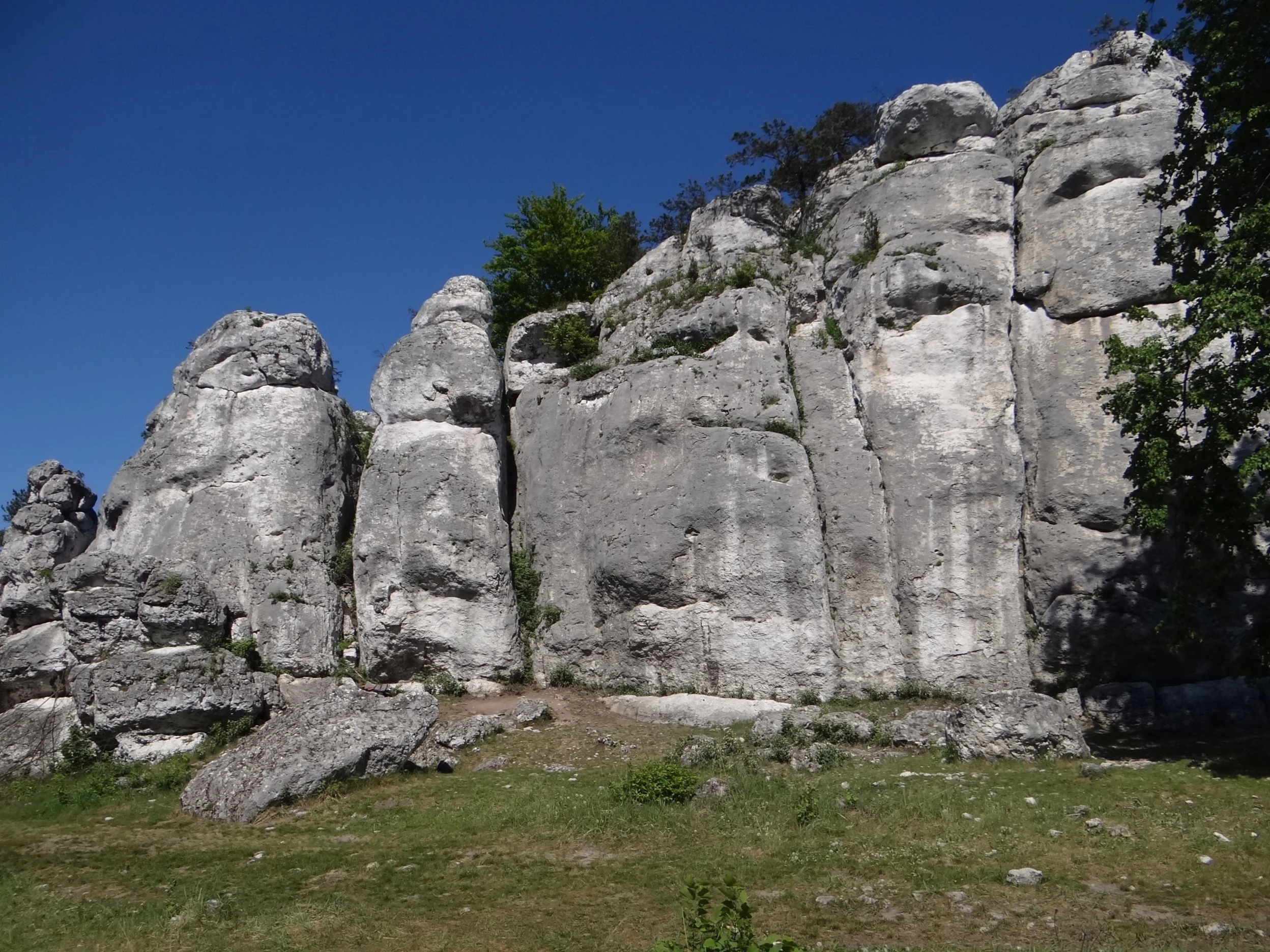
A large, light-colored limestone rock formation with vertical fissures rises above a grassy slope under a clear blue sky.
Mlyny rock formation on Gora Zborow within Ostoja Kroczycka.

Ostoja Kroczycka history and protected-area timeline

Ostoja Kroczycka received its formal Natura 2000 designation in 2011, integrating the Rzędkowickie, Morskie, Podlesickie, and Kroczyckie ranges into a single special area of habitat protection. The designation reflected long-standing recognition that this central segment of the Częstochowa Upland hosts the most diverse limestone landscapes of the region, including cave systems with important bat-hibernation value.

Between 2012 and 2016, the site became the focus of a habitat conservation project co-funded by the European Union and the National Fund for Environmental Protection and Water Management, aimed at protecting valuable non-forest habitats characteristic of the Orlich Gniazd Landscape Park. Activities included removing encroaching trees and shrubs from rocky grasslands, clearing illegal dumping sites, reintroducing sheep and goat grazing to prevent succession, restricting rock climbing on selected cliffs, conducting preventive patrols, guiding tourist traffic, and educating local residents about the natural value of the grasslands. Informational boards describing the project and the site's habitats were placed at key entry points throughout the area.

Ostoja Kroczycka landscape and geographic character

The landscape of Ostoja Kroczycka is defined by the contrast between forested Jurassic hills and abrupt limestone cliffs. Within a relatively compact footprint of roughly 1,391 hectares, the area combines four major rock ranges, each with its own morphology but sharing the same geological backbone of resistant Upper Jurassic limestone.

The Rzędkowickie, Morskie, Podlesickie, and Kroczyckie ranges present steep walls, isolated towers, rock ledges, and scree slopes. Individual cliffs can rise several tens of meters above the surrounding terrain, shaping a strongly varied relief that reads almost as small mountain country despite the upland setting. Between the ranges, gentler forested slopes, valleys, and small agricultural patches soften the transitions and connect the otherwise fragmented rocky uplands into one continuous landscape mosaic.
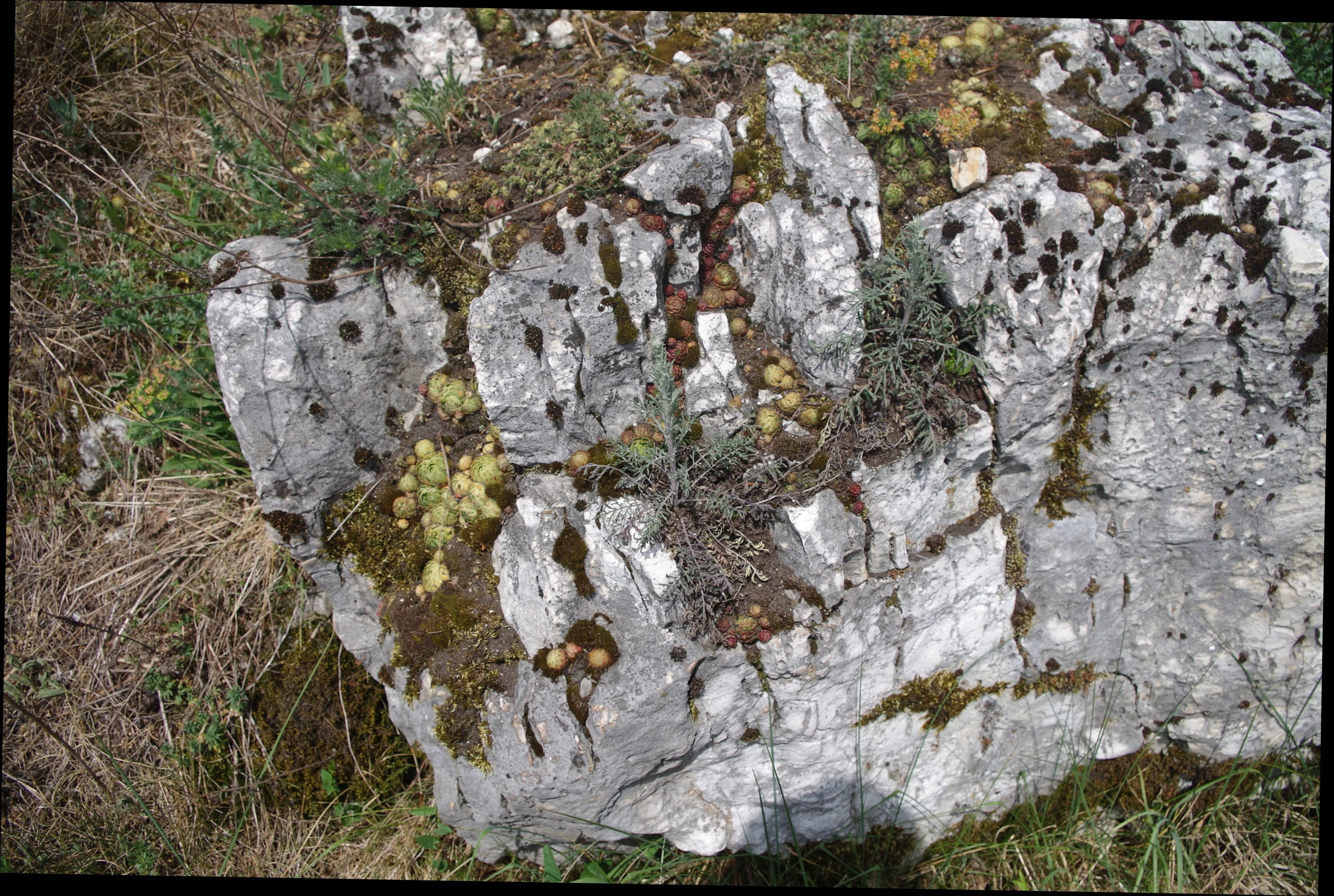
A close-up view of a weathered grey limestone rock partially covered in patches of dark moss and small green succulents in a grassy, open environment.
Limestone rock formation featuring patches of moss and small vegetation on Gora Sowia.

Ostoja Kroczycka ecosystems, habitats, and plant life

Ecologically, Ostoja Kroczycka is a textbook example of the Częstochowa Upland's habitat diversity. Forests dominate the area and itself divide into well-defined types: pine-dominated coniferous stands form the largest single share, while deciduous and mixed forests cover the rest. The deciduous component is especially significant because the site hosts substantial patches of warm-loving orchid beech forest on south- and west-facing slopes, with trees exceeding a hundred years of age and an unusually rich orchid flora in the understorey. On cooler north-facing slopes, fragments of fertile Sudeten-type beech forest have been preserved in good condition.

Outside the forests, the site's natural character is anchored by rocky habitats of exceptional botanical value. Limestone rock outcrops support stands of calcicolous rock plants and xerothermic grasslands that together cover the unforested minority of the territory. Shrub communities with Cornelian cherry, hawthorn, buckthorn, blackthorn, and common juniper frame the edges of these rocky openings, while the open rock itself hosts such rarity-rich species as the glacial relict Saxifraga paniculata, the Cheddar pink Dianthus gratianopolitanus, and the pale fescue Festuca pallens.

Ostoja Kroczycka wildlife and species highlights

Wildlife interest in Ostoja Kroczycka is dominated by bats and by the invertebrate and plant communities of the rocky grasslands and forests. The caves and rock shelters scattered throughout the four rock ranges provide hibernation sites of regional importance, with approximately twenty larger caves and a much larger network of smaller shelters offering stable, cool microclimates favored by hibernating bats.

The mosaic of habitats also supports the more generalist fauna typical of the Częstochowa Upland's mixed forests and rocky openings, although the site's conservation profile is shaped more strongly by habitat and botanical rarity than by charismatic mammal or bird populations. Old-growth orchid beech forest patches are particularly important for saproxylic invertebrates and shade-tolerant understorey species, while the open xerothermic grasslands host specialized insect and plant communities tied to warm, dry rock environments.

Ostoja Kroczycka conservation status and protection priorities

Ostoja Kroczycka is a cornerstone of Natura 2000 habitat conservation on the Częstochowa Upland, and it sits within the larger Orlich Gniazd (Eagle's Nests) Landscape Park, reinforcing its protection status. As site PLH240032, it was established in 2011 specifically to safeguard a concentration of habitat types that are otherwise fragmented across the upland: limestone rock communities, xerothermic grasslands, thermophilous orchid beech forests, and cave systems used by hibernating bats.

The 2012-2016 EU- and nationally funded habitat project strengthened this conservation framework by actively managing the open rocky habitats. Clearing invasive tree and shrub encroachment, re-establishing sheep and goat grazing, cleaning illegal dumping sites, limiting climbing pressure on selected cliffs, and running preventive patrols all aimed to keep the area's rare non-forest habitats open and in good condition. Educational signage at entry points embedded conservation awareness into the site's recreational landscape, signaling that the area is managed both for nature and for visitors.

Ostoja Kroczycka cultural meaning and human context

Although Ostoja Kroczycka is primarily valued for its natural features, the area is embedded in a long-standing regional identity tied to the Orlich Gniazd (Eagle's Nests) landscape. The famous Trail of the Eagle's Nests and the Trail of Jurassic Strongholds pass through the site, linking its rock ranges to a broader cultural narrative of medieval castles, fortified settlements, and Jurassic limestone scenery that has shaped local tourism and heritage for generations.

The local municipalities of Zawiercie, Kroczyce, Włodowice, and Niegowa have a long relationship with the surrounding rock landscape, both as everyday inhabitants and as hosts for the climbing, hiking, and cycling activity that today threads through the area.

Top sights and standout views in Ostoja Kroczycka

The four major limestone rock ranges, Rzędkowickie, Morskie, Podlesickie, and Kroczyckie, are the most visible signature of Ostoja Kroczycka, grouping some of the Częstochowa Upland's most recognizable cliffs and towers into a single protected site. Approaching 1,391 hectares, the area combines forest, agricultural land, and unforested rock in carefully balanced proportions, with forests covering about 82% of the surface.

Among the strongest ecological highlights are the thermophilous orchid beech forests, with trees over a century old and a rich orchid flora; the xerothermic grasslands and rock-plant communities on limestone outcrops; and the cave systems, some twenty larger caves among a much larger network of rock shelters, which serve as important bat-hibernation sites. Jaskinia Głęboka at Podlesice stands out as the only tourist cave in this part of the upland.

Best time to visit Ostoja Kroczycka

Ostoja Kroczycka can be appreciated year-round, but spring and early summer are typically the most rewarding seasons for visiting. In late spring the orchid beech forests are at their showiest, with Cephalanthera, Epipactis, Platanthera, and Neottia species flowering beneath the old trees, while the xerothermic grasslands on the limestone come alive with their characteristic thermophilous flora. Early summer also offers long days for exploring the rock ranges on foot or by bike.

Autumn brings vivid color to the mixed and deciduous forest stands covering most of the site, while winter, with snow on the cliffs and forests, highlights the dramatic relief of the rock ranges, especially along the Eagle's Nests hiking trails. Because the area includes both forest paths and open rock, visitors should always match their route to current weather and trail conditions rather than treating the site as a single fixed itinerary.


Monthly climate preview

Long-term representative point measurements tracking monthly temperature and precipitation rhythm

Ostoja Kroczycka Climate Normals and Measured Annual Temperature Patterns

Historical data records mean monthly temperatures ranging from winter lows below freezing to midsummer maximums above thirty degrees at a representative coordinate elevation. Examining the complete twelve-month sequence reveals detailed long-term averages for regional precipitation and thermal cycles.
Annual mean8 °C
-4 °C20 °C
Jan-4°
Feb-2°
Mar
Apr
May13°
Jun17°
Jul20°
Aug19°
Sep14°
Oct
Nov
Dec-2°
Warmest month
July

19.6 °C

Coolest month
January

-3.7 °C

Wettest month
July

3 mm/day

Driest month
December

1.4 mm/day

Park location guide

Geography guide, regional context, and park location map for Ostoja Kroczycka

Ostoja Kroczycka park geography, regions, and map view in Poland

Understand where Ostoja Kroczycka sits in Poland through a broader geographic reading of the surrounding landscape, nearby location context, and its mapped position within the national park landscape.

How Ostoja Kroczycka fits into Poland

Poland, officially the Republic of Poland, is a Central European country spanning from the Baltic Sea in the north to the Carpathian Mountains in the south. It borders Germany, Czech Republic, Slovakia, Ukraine, Belarus, Lithuania, and Kaliningrad Oblast. The country has a temperate climate, diverse landscapes, and is known for its rich history, cultural heritage, and strong economic position within the EU.

Wider geography shaping Ostoja Kroczycka in Poland

Poland occupies 312,696 km2 in Central Europe, extending from the Baltic Sea coast in the north to the Sudetes and Carpathian Mountains in the south. It borders Germany to the west, Czech Republic and Slovakia to the south, Ukraine and Belarus to the east, and Lithuania and Kaliningrad Oblast to the northeast. The landscape includes lowland plains, uplands, and mountain ranges.

Map view of Ostoja Kroczycka

Use this park location map to pinpoint Ostoja Kroczycka in Poland, understand its exact geographic position, and read its mapped placement within the surrounding landscape more clearly.

Pigeon | © OpenStreetMap contributors

Location context for Ostoja Kroczycka

Silesian Voivodeship
Recorded earthquake history

Review Recorded Earthquake History for the Ostoja Kroczycka Nature Reserve

Examine the historical catalogue of recorded seismic activity associated with Ostoja Kroczycka. This MoriAtlas collection maps reported earthquakes against the park geography to provide a clear view of regional seismic events.

Ostoja Kroczycka Earthquake History

Catalogued events

217 events

Strongest magnitude

Magnitude 4.6

Most recent event

Feb 7, 2022

This history includes earthquakes recorded inside the park or within 50 km of its borders

Visualizing limestone cliffs, forest mosaics, and karstic rock ranges across the protected upland environment

Ostoja Kroczycka Photos and Protected Landscape Scenery

Visual records capture the rugged limestone towers and forested hills defining Ostoja Kroczycka. Examining photographic terrain helps visitors understand the protected habitats and varied morphology of the upland landscape.

A large, light-colored limestone rock formation with vertical fissures rises above a grassy slope under a clear blue sky.

A large, pale limestone rock formation with a natural cave entrance set against a bright blue sky, surrounded by green trees and grass.

A close-up view of a weathered grey limestone rock partially covered in patches of dark moss and small green succulents in a grassy, open environment.

Park atlas

Compare adjacent limestone landscapes and connected habitats across the upland

Explore Parks Near Ostoja Kroczycka and Surrounding Regional Protected Areas

Browse other parks near Ostoja Kroczycka to evaluate similar karst formations, limestone cliffs, and forested ridges throughout the wider region. Extending the geographic review allows researchers and visitors to compare regional protected areas and connected conservation networks.
Protected areaSilesian Voivodeship
3.1 km away#1 closest

Northwest

Ostoja Złotopotocka: Mapping the Protected Habitats and Limestone Geography of Silesian Voivodeship

Natura 2000 protected zone in southern Poland

Ostoja Złotopotocka encompasses a rich mosaic of natural habitats across the Częstochowa Upland. From the calcareous rock faces and deep karst caves to the expansive beechwood forests and inland sand dunes, this area serves as a primary site for ecological conservation. Use this resource to understand the complex terrain, boundary layout, and structural diversity that define this protected landscape within the Polish region.

Area
27.48 km²
Relief
Upland
Climate
Temperate
Access
Access unknown
Nature reserveSilesian Voivodeship
9.6 km away#2 closest

South

Ostoja Środkowojurajska Nature Reserve: Protected Area Geography and Habitat Mapping

Regional karst terrain and protected beech forest mosaic

Analyze the geographic structure of Ostoja Środkowojurajska, a vital Natura 2000 site in the Silesian Voivodeship. This protected area features a unique concentration of inland dunes, rocky limestone outcrops, and multiple forest types. Explore the site to understand its role in regional conservation and its varied, karst-influenced physical geography.

Area
57.676 km²
Established
2009
Relief
Upland
Climate
Temperate
A soft watercolor painting of a rolling landscape featuring light-colored limestone cliffs, green hills, and a winding path, rendered in pale pastel tones.
Nature reserveSilesian Voivodeship
14 km away#3 closest

Northwest

Ostoja Olsztyńsko-Mirowska: A Detailed Map and Geographic Overview of the Protected Reserve

Karst limestone formations and diverse forest habitats in Silesian Voivodeship.

Ostoja Olsztyńsko-Mirowska stands as a centerpiece of the Częstochowa Upland, characterized by its dramatic mogotes, caves, and sheltered xerothermic grasslands. This atlas-focused entry details the area's topographic complexity, ranging from the wooded ridges of Sokole Góry to the historic limestone spurs housing medieval ruins. Uncover the ecological dynamics of this protected landscape where beech forest stands and rare cave systems form a critical regional biodiversity network.

Area
22.109 km²
Established
2008
Relief
Upland
Climate
Temperate
Watercolor painting depicting a soft-focus landscape with light sandy ground in the foreground, a line of green trees in the midground, and layered rolling hills in the background.
Protected areaMałopolskie
19 km away#4 closest

South

Pustynia Błędowska: Protected Inland Sand Dunes and Geographic Map Context in Poland

An expansive shifting sand landscape within the Małopolskie region

Pustynia Błędowska stands as a unique protected site in Poland, defined by its extensive quartz sand sheets and inland dune formations. This landscape offers a compelling look at the intersection of anthropogenic history and ecological restoration, supporting rare sand-dwelling flora and invertebrates within a specialized grassland habitat.

Area
33 km²
Established
2004
Relief
Upland
Climate
Temperate
Nature reserveSilesian Voivodeship
About 20 km away#5 closest

North

Babski Las Nature Reserve: Regional Geography and Protected Forest Landscapes in Poland

Częstochowa Upland woodland and rare fir forest ecosystems

Babski Las Nature Reserve protects a distinct mosaic of forest types within the Silesian Voivodeship. From its rare fir stands to its moisture-dependent alder carrs, this reserve offers a deep look into the ecological diversity of the Częstochowa Upland, providing vital habitat for specialized amphibians, reptiles, and forest-dwelling birds.

Area
1.124 km²
Established
2025
Relief
Lowland
Climate
Temperate
Nature reserveLesser Poland Voivodeship
About 25 km away#6 closest

South

Rezerwat przyrody Michałowiec: Protected Forest and Biodiversity in Lesser Poland

A vital beech woodland and orchid habitat in the Polish Jura

Rezerwat przyrody Michałowiec preserves a significant fragment of fertile Carpathian beech forest within the limestone-rich Olkusz Upland. Covering 12 hectares, this nature reserve is a critical component of the regional conservation mosaic, protecting rare orchid populations and maintaining the ecological continuity of the broader Orlich Gniazdy Landscape Park terrain.

Area
0.121 km²
Established
1959
Relief
Upland
Scope
Terrestrial
A soft watercolor painting of a wide, rolling landscape with green hills, patches of trees, and subtle pink ground tones.
Protected areaPoland
25 km away#7 closest

Northwest

Przełom Warty koło Mstowa: Mapping the Protected River Corridor and Limestone Geography

A critical geological breakthrough in the Częstochowa Upland.

This protected area features a twelve kilometer river gorge carved by the Warta. The terrain is characterized by dramatic limestone outcrops such as the Brama Mirowska, paired with rich meadow habitats and oak hornbeam forests. Explore the intersection of geology and conservation within this key corridor of the Polish Jura, where river dynamics meet ancient upland landscapes.

Relief
Upland
Climate
Temperate
Scope
Terrestrial
Water
Major water bodies
Protected areaSilesian Voivodeship
28 km away#8 closest

Southwest

Łąki w Sławkowie Protected Area: Silesian Voivodeship Landscape and Map Analysis

Mapping rare fen and meadow habitats in southern Poland

Łąki w Sławkowie is a crucial protected habitat area situated west of Sławków. Its landscape consists of four connected enclaves characterized by wet meadow communities and calcareous fens. This data-driven overview highlights the site's hydrological and ecological significance within the broader Silesian Voivodeship and Poland's Natura 2000 network.

Area
0.51 km²
Relief
Lowland
Scope
Terrestrial
Water
Minor water

Common questions about visiting, size, designation, and location context for Ostoja Kroczycka

Ostoja Kroczycka FAQs for park facts, access, geography, and protected area context

Find quick answers about Ostoja Kroczycka, including protected-area facts, park geography, trail and visitor context, and how the park fits into its surrounding country and regional landscape.
MoriAtlas Explorer

Continue Your Protected Areas Search Across the Global Atlas

Deepen your exploration by continuing the structured search for national parks and protected areas worldwide. Utilize the comprehensive filtering capabilities to compare different conservation landscapes and refine your understanding of global park geography. Discover more about the distribution and characteristics of protected natural areas.

Global natural geography