
Mori Atlas logo
Protected landscapeOttilienberg

A study of geographic boundaries, orchard meadows, and distinctive hilltop terrain

Ottilienberg Protected Landscape: Mapping the Keuper Outlier Hill in Baden-Württemberg

(Landschaftsschutzgebiet „Ottilienberg“)

Ottilienberg represents a geomorphologically significant protected landscape rising above Schorndorf in the Rems-Murr district. This classic Keuper outlier hill defines the local skyline with its oak-dominated woodland and traditional orchard meadows. The site functions as a vital green island where cultural history and natural terrain intersect within the broader Swabian Keuper-Lias region.

landscape protection areaLandschaftsschutzgebietKeuper outlier hillZeugenbergorchard meadowsStreuobstwiesen
A stylized digital illustration of a green hill, Ottilienberg, with a small village nestled at its base, surrounded by fields and trees under a soft, golden sky.

Ottilienberg

Protected landscape

Park overview

Structured park overview, official facts, and landscape profile for Ottilienberg Landscape Protection Area

Ottilienberg Landscape Protection Area park facts, protected area profile, and essential visitor context

Review the core facts for Ottilienberg Landscape Protection Area, including designation, size, terrain, visitor scale, habitats, and operating context in one park-focused overview.

About Ottilienberg Landscape Protection Area

Ottilienberg is a small but distinctive landscape protection area in the Rems-Murr-Kreis district of Baden-Württemberg, anchored on the hill of the same name above the town of Schorndorf. Although the protected area covers only about 8.3 hectares, it preserves an entire summit landscape that visually defines the southern edge of the town. The protected zone extends right up to the built-up areas of Schorndorf, and in the northern part a few already developed plots actually lie within its boundaries, reflecting how tightly the landscape and the town are interlinked.

Geologically and geomorphologically, the Ottilienberg is one of the so-called Zeugenberge, isolated outlier hills, that characterize parts of the Swabian cuesta landscape. Its rounded, cone-like summit profile in Keuper strata gives it a strong, recognizable shape on the horizon and is the foundation of the area’s special character. The hill is part of the broader Schurwald and Welzheimer Wald natural region, which belongs to the larger Swabian Keuper-Lias-Land natural unit, an area shaped by alternating sandstone and clay layers that create a sequence of forested ridges, valleys and isolated hills.

Landscape quality, biodiversity support and recreational usefulness are all formally recognized in the protection ordinance. The site’s traditional orchard meadows (Streuobstwiesen) are considered an essential component of the landscape image and are integral to the area’s identity. In addition, the oak-dominated field grove on the hill’s silicified sandstone knoll provides important biotope structure. The protected area sits at the edge of an interconnected network of conservation sites, with the broader EU bird protection area Nr. 7123-441 covering orchard and vineyard landscapes between Geradstetten, Rudersberg and Waldhausen to one side, and the Schurwald FFH area Nr. 7222-341 on another, reinforcing its role as a node in a wider ecological landscape rather than an isolated patch.

Quick facts and research context for Ottilienberg Landscape Protection Area

Established by ordinance of the former Waiblingen district office on 4 November 1968, Ottilienberg was placed under a new legal framework by the Rems-Murr-Kreis ordinance of 29 October 2018. The site’s working identification number in the Baden-Württemberg register of protected areas is 1.19.016, and its World Database on Protected Areas (WDPA) record is 323602. It covers around 8.3 hectares, encompasses the full summit area of the Ottilienberg, and is administered by the Rems-Murr district.

The area is classified as an IUCN Category V Protected Landscape/Seascape and falls within the Schurwald and Welzheimer Wald natural region. It borders the adjacent landscape protection area of Rehfeld, Hof, Steinmäurich, Heiligenäcker und Umgebung and is close to the EU bird protection area Nr. 7123-441 and to the Schurwald FFH area Nr. 7222-341.

Protection and recognition

Explore documented designation records and management scope for Ottilienberg.

Ottilienberg Protection Status and Terrestrial Conservation History

Ottilienberg holds official terrestrial protected area status established in 2018 under recorded geographic frameworks. Conservation records outline the designated timeline and framework scope associated with this protected landscape.

Protection details

Protection scope
Terrestrial
Designated year
2018
Transboundary protection
No
WDPA ID
323602
Park context

Deeper park guide and search-rich context for Ottilienberg Landscape Protection Area

Ottilienberg Landscape Protection Area history, landscape, wildlife, and travel context

Explore Ottilienberg Landscape Protection Area through its history, landscape character, ecosystems, wildlife, conservation priorities, cultural context, and seasonal travel timing in a structured park guide built for atlas discovery and search intent.

Why Ottilienberg Landscape Protection Area stands out

Ottilienberg is best known as a remarkably well-preserved Keuper outlier hill rising directly above the southern settlement edge of Schorndorf. Its iconic, almost circular hilltop silhouette gives it strong geomorphological identity, while its traditional orchard meadows and oak-dominated woodland patches give the protected area a recognizable cultural and ecological character. The site is also valued as a compact but meaningful local recreation landscape, where farmland, orchards, woodland and edge-of-town settlement meet, illustrating how cultural-historic landscapes can be preserved in close proximity to an urban environment.
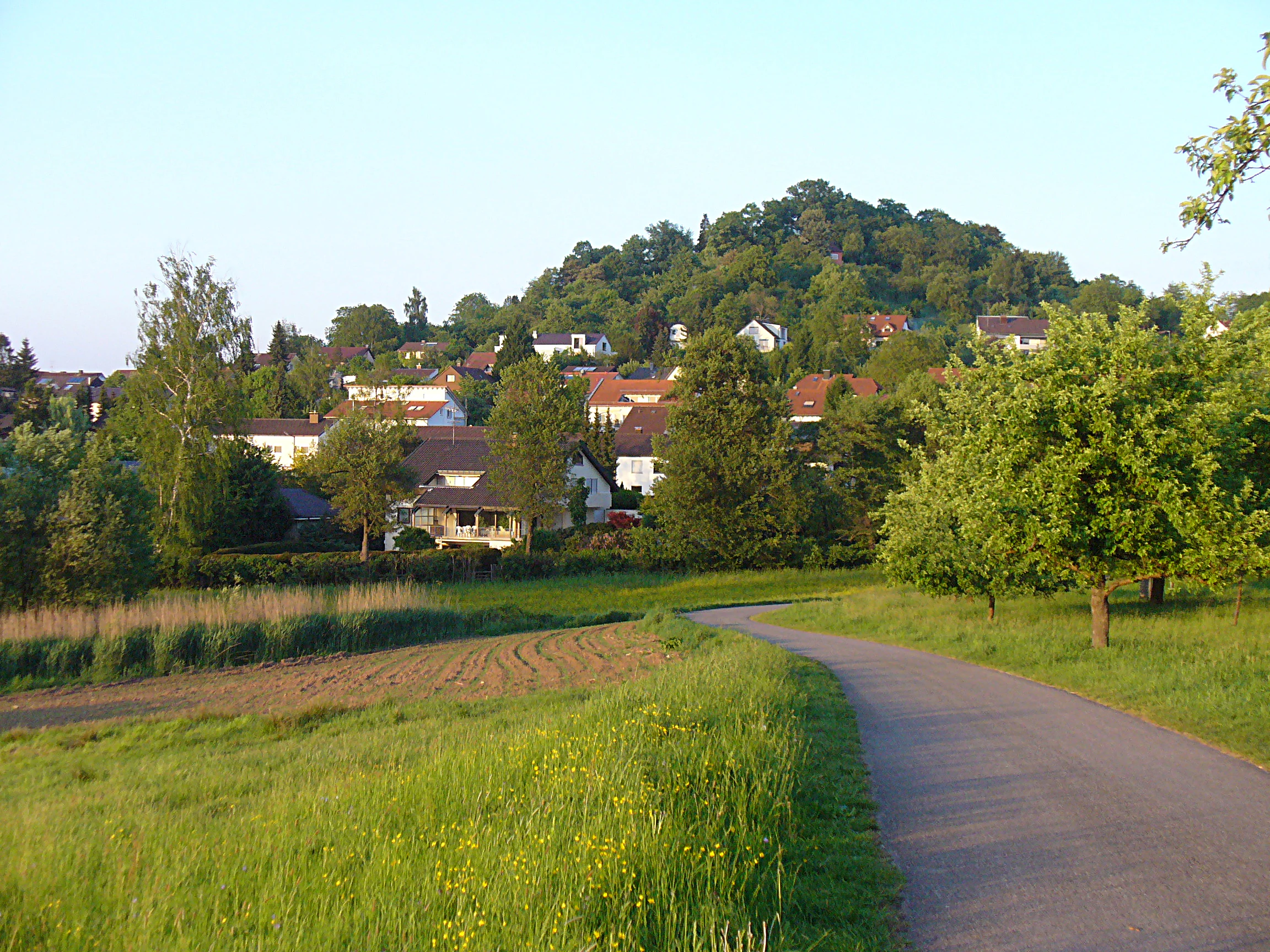
A paved path leads through a grassy field towards a forested hill, with several houses visible at the foot of the slope.
A view of the west flank of the Ottilienberg hill in Schorndorf, showing a paved path leading toward the residential area nestled at the base of the forested hillside.

Ottilienberg Landscape Protection Area history and protected-area timeline

The Ottilienberg landscape protection area was first established on 4 November 1968 by ordinance of the former Landratsamt Waiblingen, the Waiblingen district office, as part of a wider effort to safeguard landscape elements across what was then the Waiblingen district. The 1968 ordinance laid the foundations for the area’s long-standing protected status.

In the decades that followed, administrative reorganization transformed the old Waiblingen district into the modern Rems-Murr-Kreis, and the legal framework for the protected area had to be updated accordingly. On 29 October 2018, the Rems-Murr-Kreis issued a new ordinance specifically focused on the Ottilienberg site. This 2018 ordinance established the area on a contemporary legal basis and replaced the relevant portions of the older 1968 instrument.

Today, the landscape protection area is administered by the Rems-Murr-Kreis and is recorded in the official Baden-Württemberg nature conservation register under protection area number 1.19.016. It is also registered internationally in the World Database on Protected Areas under record 323602, signaling its place within broader European landscape protection frameworks.

Ottilienberg Landscape Protection Area landscape and geographic character

The landscape of the Ottilienberg protection area is defined above all by the rounded, conical silhouette of the Ottilienberg itself, which is widely recognized as a textbook example of a Keuper Zeugenberg, an isolated hill that has resisted erosion while surrounding softer rocks were worn down. This geomorphological signature gives the site a strong topographic identity and sets it apart from the more continuous ridges of the nearby Schurwald.

The summit region of the hill forms the core of the protected area, including both the woody crest and the lower orchard-covered slopes that descend toward the southern edge of Schorndorf. A Kieselsandstein, or silicified sandstone, knoll near the top hosts one of the area’s most distinctive features, an oak-dominated field grove. Together with scattered additional woody patches, this grove creates structural variety in what is otherwise a relatively compact, settlement-adjacent landscape.

The wider setting belongs to the Schurwald and Welzheimer Wald natural region, part of the Swabian Keuper-Lias landscape, an area of gently folded forested ridges and valleys underlain by Triassic and Jurassic strata. From the summit and upper slopes, the protected area is closely framed by the town of Schorndorf on one side and adjacent protected landscapes and ecological zones on the others, giving the hill the feel of a green island between urban and rural land uses.

Ottilienberg Landscape Protection Area ecosystems, habitats, and plant life

Ecologically, Ottilienberg is shaped by the interplay of orchard meadows, oak-dominated woodland and small-scale open habitats typical of southern German Keuper landscapes. The Streuobstwiesen, traditional extensively managed orchards, dominate significant portions of the protected area and are explicitly recognized in the ordinance as ecologically valuable land use. Such orchards provide a mosaic of grassy understorey, scattered fruit trees of various ages, and edge structures that together create rich habitat diversity.

On the higher ground, an oak-dominated field grove on the silicified sandstone knoll adds woodland character and structural diversity. These oak patches are protected alongside additional woody features that contribute to the visual and ecological identity of the site. The combination of orchard, woodland and open ground produces an unusually high habitat density for such a small area, especially given its position right at the edge of a built-up town.

In a broader context, Ottilienberg sits within a denser network of higher-tier conservation zones, neighboring the EU bird protection area Nr. 7123-441, with its mosaic of orchard and vineyard landscapes between Geradstetten, Rudersberg and Waldhausen, and the Schurwald FFH area Nr. 7222-341, which protects the forested terrain to which the Ottilienberg essentially acts as a small southeastern outlier.

Ottilienberg Landscape Protection Area wildlife and species highlights

The Ottilienberg protection area does not present itself as a dedicated wildlife sanctuary, but its mosaic of orchards, oak woodland patches and edge structures creates valuable habitat conditions in close proximity to the urban fabric. Traditional orchard meadows in this part of Baden-Württemberg are well known for supporting a wide range of insects, including wild bees and other pollinators, as well as birds, bats and small mammals that depend on the combination of old trees, varied understorey and adjacent woodland edges.

The oak-dominated grove on the sandstone knoll adds woodland-dependent species to this mix, providing habitat for insects associated with oak and for cavity-nesting birds. Fruit trees in the orchard meadows often host nesting sites for species adapted to traditional rural landscapes, while the open grassy areas below them offer foraging opportunities for a variety of birdlife. The location at the very edge of Schorndorf further increases the area’s significance as a refuge and stepping stone for wildlife in an otherwise heavily settled landscape.

The protected area’s proximity to the larger EU bird protection area Nr. 7123-441, which is dedicated to birdlife in the orchard and vineyard landscapes between Geradstetten, Rudersberg and Waldhausen, means that Ottilienberg also contributes to the broader conservation of birds associated with this kind of culturally shaped habitat mosaic.

Ottilienberg Landscape Protection Area conservation status and protection priorities

The conservation significance of the Ottilienberg landscape protection area rests on its formal role as one of the locally anchoring pieces of the broader Rems-Murr protected-area network and on the specific qualities of the Ottilienberg hill itself. Under the 2018 ordinance, the principal purpose of the protected area is to safeguard the diversity, distinctiveness and beauty of the landscape, as well as its particular cultural-historical significance, its value for local recreation, and the long-term functioning and regenerative capacity of the natural environment.

A second explicit objective is the preservation of the Ottilienberg as a remarkably distinctive Keuper outlier hill with a geomorphologically striking, rounded cone shape. This protects not only the visual identity of the hill but also the geological features that underlie its character. In practical terms, the conservation framework aims to keep the hill as an open landscape and important local recreation space on the southern fringe of Schorndorf.

Equally important is the conservation of land use: the ordinance specifically seeks the sustainable continuation of traditional orchard meadow management on the slopes, recognizing these orchards both as habitat and as a defining element of the landscape. Protection also extends to the oak-dominated woodland on the silicified sandstone knoll and to other woody structures that complete the area’s ecological identity. By connecting to adjacent protected areas, including the EU bird protection area Nr. 7123-441 and the Schurwald FFH area Nr. 7222-341, the Ottilienberg fits into a wider conservation landscape of orchard, vineyard and forest habitats typical of this part of Baden-Württemberg.

Ottilienberg Landscape Protection Area cultural meaning and human context

The cultural dimension of the Ottilienberg landscape is closely linked to the long-standing agricultural and settlement patterns of the Schorndorf area. Traditional Streuobstwiesen, extensively managed orchard meadows with mixed fruit trees such as apples, pears and cherries, are a defining feature of the local cultural landscape and have shaped settlement-edge scenery around Schorndorf for generations. Their continued presence on the Ottilienberg reflects the persistence of this traditional land use right up to the modern town boundary.

The hill itself, rising right behind the southern settlement edge, has long functioned as a familiar local landmark. Its position between town and countryside gives it a particular cultural weight: it is simultaneously a viewpoint over the broader landscape, a marker of the Schorndorf skyline, and a familiar local recreation area for residents. The ordinance specifically recognizes both the cultural-historical importance of the landscape and its particular role for recreation, underlining how the site is valued not only ecologically but also as part of regional identity and everyday life.

In a wider regional context, the Ottilienberg belongs to a chain of similar Keuper outlier hills and orchard-clad slopes that have historically shaped the cultural landscape of the Rems-Murr-Kreis and surrounding parts of Baden-Württemberg, where small-scale farming, viticulture and fruit growing have long coexisted with woodland.

Top sights and standout views in Ottilienberg Landscape Protection Area

The Ottilienberg protection area stands out for combining a striking, rounded Keuper outlier hill with classic Swabian orchard meadows, oak-dominated woodland patches and direct adjacency to an urban settlement. Its compact size, only around 8.3 hectares, belies the density of natural, cultural and recreational value packed into the hilltop.

The site is also notable for the formal clarity of its modern protection status: classified under the IUCN framework as a Category V Protected Landscape/Seascape and registered in the World Database on Protected Areas, it sits within a broader network of landscape protection areas in the Rems-Murr-Kreis and is closely linked to higher-tier EU bird and habitats protection zones that extend well beyond the Ottilienberg itself.

Best time to visit Ottilienberg Landscape Protection Area

The character of the Ottilienberg shifts clearly with the agricultural and ecological rhythm of the southern German orchard landscape. In spring, the orchard meadows on the slopes come into blossom, producing a strong seasonal visual display of white and pale pink flowers framed by the darker woodland on the summit. This is also a particularly lively period for pollinators, insect activity and early birdlife in the orchard mosaic.

Summer is the most intensively used season for local recreation, with the hill acting as a green escape right at the edge of Schorndorf: open grassy orchard floors, mixed woodland patches and viewpoints over the surrounding Schurwald and Welzheimer Wald natural region make the area attractive for short walks. Autumn brings ripe orchard fruit, harvest activity in the meadows and rich foliage colors in the oaks on the sandstone knoll. In winter, the hilltop retains an open, uncluttered silhouette against the surrounding settlement, and the wooded crest takes on a quieter, more austere tone, while the open orchard slopes still allow clear views over the southern edge of Schorndorf.

Monthly climate preview

Review measured monthly averages, temperature ranges, and precipitation rhythms for Ottilienberg

Ottilienberg Climate Normals and Long Term Temperature and Precipitation Patterns

Long term climate data for Ottilienberg reveals a structured annual rhythm defined by measured monthly average temperatures and daily precipitation rates across the representative coordinate point. Examining the complete twelve month profile provides deeper insight into historical temperature variations and precipitation distribution.
Annual mean9 °C
0 °C20 °C
Jan
Feb
Mar
Apr
May13°
Jun17°
Jul20°
Aug20°
Sep15°
Oct10°
Nov
Dec
Warmest month
July

19.6 °C

Coolest month
January

-0.2 °C

Wettest month
July

2.7 mm/day

Driest month
April

1.6 mm/day

Park location guide

Geography guide, regional context, and park location map for Ottilienberg Landscape Protection Area

Ottilienberg Landscape Protection Area park geography, regions, and map view in Germany

Understand where Ottilienberg Landscape Protection Area sits in Germany through a broader geographic reading of the surrounding landscape, nearby location context, and its mapped position within the national park landscape.

How Ottilienberg Landscape Protection Area fits into Germany

Germany is a federal republic in Western and Central Europe with a population of over 83 million across sixteen constituent states. It is Europe's largest economy by nominal GDP and a major global exporter and importer. The capital is Berlin, and the country borders Denmark, Poland, Czech Republic, Austria, Switzerland, France, Luxembourg, Belgium, and the Netherlands.

Wider geography shaping Ottilienberg Landscape Protection Area in Germany

Germany is located in Western and Central Europe, spanning 357,022 km². It borders Denmark to the north, Poland and the Czech Republic to the east, Austria and Switzerland to the south, and France, Luxembourg, Belgium, and the Netherlands to the west. The country has coastlines on the Baltic Sea and North Sea to the north, with the Alps located in the southern region.

Map view of Ottilienberg Landscape Protection Area

Use this park location map to pinpoint Ottilienberg Landscape Protection Area in Germany, understand its exact geographic position, and read its mapped placement within the surrounding landscape more clearly.

Pigeon | © OpenStreetMap contributors

Location context for Ottilienberg Landscape Protection Area

Baden-Württemberg

Visualizing the distinctive hill terrain, oak woodlands, and traditional orchard meadows of the protected area

Ottilienberg Photos and Protected Landscape Scenery

Visual records capture the rounded geomorphological profile of the Keuper outlier hill and its surrounding orchard habitats. Examining these protected landscapes reveals the unique topographic identity of the summit environment.

A paved path leads through a grassy field towards a forested hill, with several houses visible at the foot of the slope.

Park atlas

Compare regional protected areas and connected terrain within the Swabian cuesta landscape

Exploring Other Parks Near Ottilienberg and Surrounding Protected Landscapes

Visitors reviewing Ottilienberg can examine adjacent protected areas, regional hill formations, and connected conservation zones across the surrounding district. Expanding the geographic scope reveals how similar landscape protection areas and woodland reserves anchor regional biodiversity.
A watercolor painting showing a soft green landscape with rolling hills, a distant mountain range, and flowering trees.
Protected landscapeBaden-Württemberg
About 6.5 km away#1 closest

Southeast

Nassachtal Protected Landscape: Geographic Overview and Mapped Terrain in Baden-Württemberg

Conservation geography of the Nassach stream catchment area.

Covering the full extent of the Nassach valley in southwestern Germany, this protected landscape serves as a critical ecological link between forest and agricultural zones. The terrain encompasses a typical Swabian hill country profile with incised stream valleys and wooded ridges, securing natural continuity across the Schurwald and Welzheimer Wald regions.

Area
21.666 km²
Established
1982
IUCN
V
Relief
Upland
Protected landscapeBaden-Württemberg
About 8 km away#2 closest

Northwest

Zipfelbachtal, Korber Kopf, Buocher Höhe, Remstalhänge, Ramsbachtal und Grafenberg Protected Landscape Map

Mapping the Keuper cultural landscape of Baden-Württemberg

Study the intricate topography and land use patterns of this expansive protected area in the Rems-Murr-Kreis. The region preserves a variety of habitats, including vineyard slopes, traditional Streuobst orchards, and forested ravines, providing a clear window into the natural and agricultural heritage of the eastern Stuttgart region.

Area
20.856 km²
Established
1968
IUCN
V
Relief
Upland
Protected landscapeLandkreis Esslingen
About 14 km away#3 closest

Southwest

Wernau (Neckar) Protected Landscape: Geographic Overview and Mapped Cultural Terrain

Landscape protection area within the Landkreis Esslingen region

Trace the boundaries of the Wernau (Neckar) protected landscape, an ecologically significant mosaic of meadow orchards, riparian vegetation, and small woodlands. Situated in the Landkreis Esslingen of Baden-Württemberg, this area functions as a critical buffer zone that maintains the continuity of local habitats between the Filder plain and the Swabian Alb foothills.

Area
2.27 km²
Established
1995
IUCN
V
Protected landscapeBaden-Württemberg
About 14 km away#4 closest

South

Notzingen Protected Landscape: Mapping the Voralb Foothills and Swabian Alb Terrain

Regional protected area analysis in Landkreis Esslingen

Notzingen represents a coherent protected landscape composed of three parcels near the Swabian Alb foothills. The area is defined by a delicate intersection of stream-side riparian habitats and traditional Streuobstwiesen orchard meadows. This atlas-focused entry provides spatial context for understanding how these protected lands maintain the character of the southern German countryside.

Area
3.15 km²
Established
1989
IUCN
V
Relief
Upland
Protected landscapeOstalbkreis
About 16 km away#5 closest

Northeast

Welzheimer Wald mit Leintal Protected Landscape, Germany: Mapped Forest and Valley Geography

A large-scale Keuper forest reserve in the Ostalbkreis region

Welzheimer Wald mit Leintal is a designated protected landscape encompassing an unspoiled mosaic of mixed woodland and river valleys in southwestern Germany. This area forms a vital geographic link between the Schurwald and the Swabian-Franconian Forest, offering a prime example of the Keuper hill country terrain within the Ostalbkreis administrative district.

Area
54.894 km²
Established
1972
IUCN
V
Relief
Upland
Protected landscapeBaden-Württemberg
About 16 km away#6 closest

South

Wolfschlugen Protected Landscape: Geography and Atlas of the Filder Plateau

Mapped protected lands in Baden-Württemberg Germany

Wolfschlugen stands as a significant protected area in the Esslingen district, preserving traditional orchard meadows and open agricultural plains. The area offers a detailed study of regional land use, featuring a mosaic of meadow habitats and stream-side wetlands essential to the Filder plateau landscape character.

Area
0.51 km²
Established
1985
IUCN
V
Protected landscapeBaden-Württemberg
About 16 km away#7 closest

North

Landschaftsschutzgebiet Murrhardter Wald: Protected Landscape and Regional Geography

Keuper forest formations in the Rems-Murr-Kreis region

Spanning over 2,000 hectares across multiple municipal territories, the Landschaftsschutzgebiet Murrhardter Wald protects an intact forest and valley system in the eastern Swabian hill country. The mapped geography highlights a complex interplay of forested heights and narrow valley cuts, serving as a critical example of protected countryside land use in southwestern Germany.

Area
23.403 km²
Established
1971
IUCN
V
Relief
Upland
Protected landscapeBaden-Württemberg
About 16 km away#8 closest

Southwest

Unteres Körschtal Protected Landscape: Geography and Mapped Boundaries in Baden-Württemberg

An ecological green corridor within the Swabian Keuper-Lias landscape

Unteres Körschtal protects the natural valley floor and adjacent slopes of the lower Körsch river. This landscape conservation area provides essential habitat and recreational space between the Filder plateau and the Neckar valley, standing as a primary example of regional geography in Germany.

Area
4.729 km²
Established
1978
IUCN
V

Common questions about visiting, size, designation, and location context for Ottilienberg Landscape Protection Area

Ottilienberg Landscape Protection Area FAQs for park facts, access, geography, and protected area context

Find quick answers about Ottilienberg Landscape Protection Area, including protected-area facts, park geography, trail and visitor context, and how the park fits into its surrounding country and regional landscape.
MoriAtlas Explorer

Continue Your Protected Areas Search Across the Global Atlas

Deepen your exploration by continuing the structured search for national parks and protected areas worldwide. Utilize the comprehensive filtering capabilities to compare different conservation landscapes and refine your understanding of global park geography. Discover more about the distribution and characteristics of protected natural areas.

Global natural geography