
Mori Atlas logo
National parkPanglao Island Protected Seascape

Analyzing the limestone karst island features and diverse reef habitats within the Bohol Sea.

Panglao Island Protected Seascape: Mapping the Biodiversity and Marine Geography of a Philippine National Protected Area

Panglao Island Protected Seascape represents a critical marine and coastal landscape within Central Visayas, defined by the unique interaction between coralline limestone geology and the productive waters of the Bohol Sea. This protected area encompasses diverse reef formations, offshore islets, and submerged karst structures that support exceptionally high concentrations of marine species. By examining the structural complexity of these coastal environments, observers can understand the ecological and geological significance of this nationally designated zone.

marine protected areacoral reeftropical islandkarst landscapelimestone islandBohol Sea
An illustrative style image of a tropical cove with palm trees, a shallow sandy beach, a traditional outrigger boat in turquoise water, and large limestone cliffs in the background under a sunset sky.

Panglao Island Protected Seascape

National park

Park overview

Structured park overview, official facts, and landscape profile for Panglao Island Protected Seascape

Panglao Island Protected Seascape park facts, protected area profile, and essential visitor context

Review the core facts for Panglao Island Protected Seascape, including designation, size, terrain, visitor scale, habitats, and operating context in one park-focused overview.

About Panglao Island Protected Seascape

Panglao Island Protected Seascape is a national protected seascape in the Philippines, anchored on Panglao Island in the Bohol Sea and encompassing the surrounding reef and coastal waters. The seascape sits in the Central Visayas region of the Visayas island group, within Bohol Province, and forms part of a broader Philippine effort to formally conserve marine ecosystems that support both biodiversity and coastal livelihoods.

Panglao Island itself is a roughly oblong tropical landmass made primarily of Maribojoc limestone, the youngest limestone formation recognized in the western part of Bohol. This young, coralline limestone gives the island its characteristic karst character, contributing to the formation of caves, sinkholes, and subterranean water systems such as Hinagdanan Cave. Importantly, the same limestone foundations extend offshore, shaping the reef structures and underwater habitats that the protected seascape is designed to conserve.

The waters around the island together with several smaller offshore islets, including Balicasag, Gak-ang, and Pontod, form a marine system of outsized biological significance. Scientific surveys through the Panglao Marine Biodiversity Project documented large numbers of crustacean and mollusk species, demonstrating that the area surpasses much larger marine regions in species richness. The presence of dolphin populations, reef-associated fauna, and a wide variety of marine invertebrates has reinforced the area's standing as a marine biodiversity hotspot.

The seascape was formally protected under Republic Act No. 11038, the Expanded National Integrated Protected Areas System Act of 2018, signed by President Rodrigo Duterte. This legal designation integrates Panglao's coastal waters into the national protected area framework, ensuring formal recognition of the area's ecological value, supporting long-term conservation planning, and acknowledging the role of healthy reef systems in sustaining fisheries, tourism, and coastal resilience across the Central Visayas.

Quick facts and research context for Panglao Island Protected Seascape

Panglao Island Protected Seascape is a nationally designated protected area in the Philippines, centered on and around Panglao Island in the Bohol Sea. It lies within Bohol Province in the Central Visayas region, southwest of Bohol Island and adjacent to Cebu. The seascape was legally established in 2018 under the Expanded National Integrated Protected Areas System Act. Its core geographic context is a small tropical island and its surrounding reef and coastal waters, known for exceptionally high marine species diversity, including extensive records of crustaceans and mollusks documented by the Panglao Marine Biodiversity Project.

Protection and recognition

Explore documented conservation scope and formal establishment records for Panglao Island Protected Seascape.

Panglao Island Protected Seascape Protection Status and Designation History

Comprehensive protected area records for Panglao Island Protected Seascape outline mixed management scope and formal designation established in 2018. Structured conservation data details official protection status and international recognition frameworks associated with the marine landscape.

Protection details

Protection scope
Mixed
Designated year
2018
Park context

Deeper park guide and search-rich context for Panglao Island Protected Seascape

Panglao Island Protected Seascape history, landscape, wildlife, and travel context

Explore Panglao Island Protected Seascape through its history, landscape character, ecosystems, wildlife, conservation priorities, cultural context, and seasonal travel timing in a structured park guide built for atlas discovery and search intent.

Why Panglao Island Protected Seascape stands out

Panglao Island Protected Seascape is best known for its extraordinary marine biodiversity, particularly the concentration of crustacean and mollusk species documented around Panglao Island and its associated islets and reefs. Research under the Panglao Marine Biodiversity Project established that the waters around the island host more marine species than the entire Mediterranean Sea or the seas around Japan, drawing global scientific attention to a small tropical seascape. The area is also recognized for the clarity and productivity of its coastal waters, supported by limestone reef geology and small offshore islands such as Balicasag, Gak-ang, and Pontod. This combination of high species counts, reef habitat quality, and accessibility from a major Philippine tourism hub has made the Panglao marine environment a benchmark example of tropical marine biodiversity in Southeast Asia.
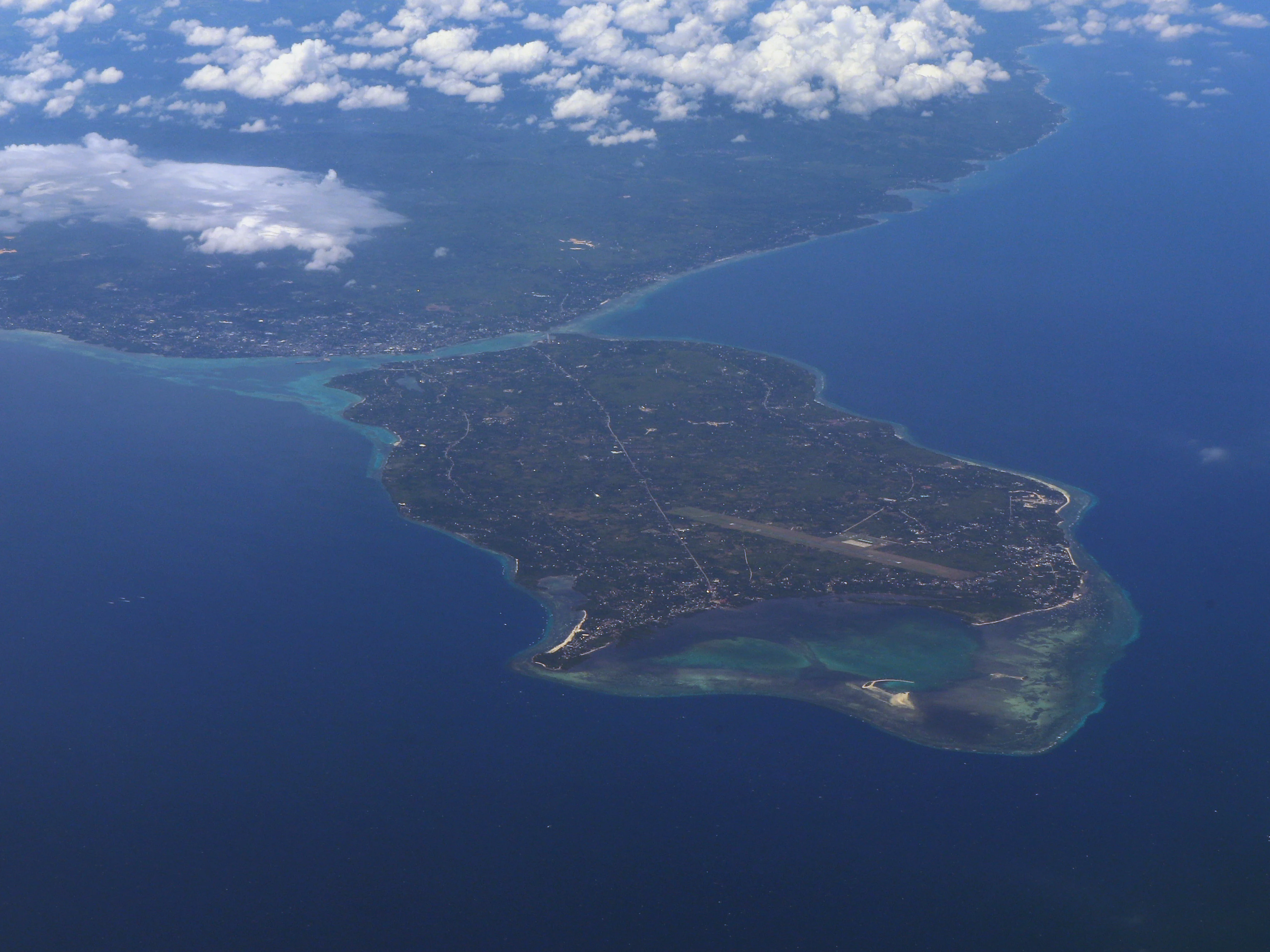
An aerial view of an island surrounded by deep blue ocean water, with a clear separation between the island landmass, shallow turquoise coral reefs, and the deep sea.
Aerial perspective of Panglao Island, showcasing its coastal geography and surrounding seascape.

Panglao Island Protected Seascape history and protected-area timeline

Panglao Island has a long human history that predates modern conservation efforts. Before Spanish colonization, the island was part of the precolonial polity known as the Kedatuan of Bo-ol, and it was a known point of contact for Chinese, Malay, Siamese, and Indonesian traders moving through the Visayan sea routes. The Kedatuan of Bo-ol was eventually attacked by the Ternate Sultanate and was later reorganized as a Spanish protectorate in Dapitan. By the time of the 1818 census, the settlement of Dauis on Panglao had 2,055 native families alongside a smaller number of Spanish and Mexican families who had already assimilated into the local population.

While the island's human history stretches back centuries, formal recognition of its marine environment as a nationally significant protected seascape is recent. In July 2018, President Rodrigo Duterte signed Republic Act No. 11038, the Expanded National Integrated Protected Areas System Act, which legally designated the waters and reef systems around Panglao Island as the Panglao Island Protected Seascape. This designation came alongside growing scientific evidence from the Panglao Marine Biodiversity Project, which had highlighted the exceptional marine species richness of the area and underscored the need for formal conservation protection.

The declaration of the seascape reflects a broader national strategy to safeguard Philippine coastal and marine ecosystems through an integrated protected areas framework. For Panglao, this milestone marked a shift from informal recognition of the island's ecological value to a legally anchored, nationally coordinated conservation effort focused on sustaining its reefs, coastal waters, and dependent biodiversity into the future.

Panglao Island Protected Seascape landscape and geographic character

The landscape of Panglao Island Protected Seascape is defined by the interplay between a small tropical island and its surrounding marine environment. Panglao Island itself has a varied terrain that ranges from coastal plains to rolling hills and small mountainous areas, all shaped by the underlying Maribojoc limestone. This young, coralline limestone is more soluble than older limestone formations, and over geological time its dissolution has produced a karst landscape marked by caves, sinkholes, and underground water systems. The island has no rivers or lakes, and important freshwater sources such as Hinagdanan Cave, with its underground water pool, play a significant role in the local hydrology.

Offshore, the same limestone geology continues to define the seascape. The seabed around Panglao and its associated islets is shaped by coralline reef structures that rise from the Bohol Sea. Several small islands and rocky outcrops, including Balicasag, Gak-ang, and Pontod, sit within or adjacent to the protected waters, adding structural complexity to the reef environment and creating varied habitats for marine life.

The visual character of the area combines white-sand beaches, clear coastal waters, and gently undulating limestone hills on land, with submerged reef formations and deep channels offshore. This juxtaposition of terrestrial karst features and productive marine reef systems gives the protected seascape a distinctive geography that supports both terrestrial and aquatic ecological processes.
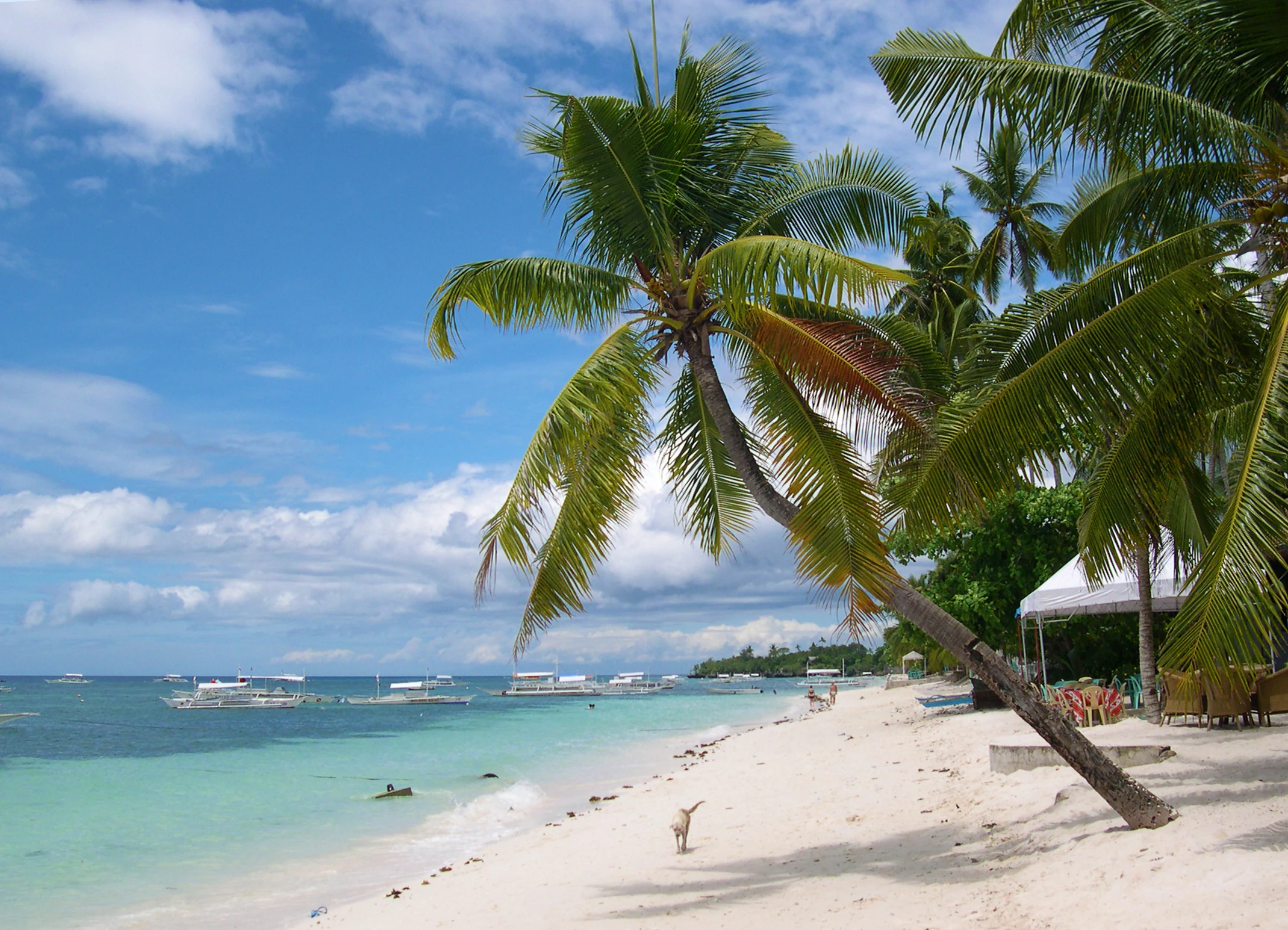
A sandy tropical beach with a large leaning palm tree in the foreground, turquoise water with outrigger boats, and a bright blue sky with clouds.
A palm tree leaning over the white sands of Alona Beach, Panglao Island.

Panglao Island Protected Seascape ecosystems, habitats, and plant life

The ecological character of Panglao Island Protected Seascape is overwhelmingly marine, anchored by tropical reef ecosystems in the Bohol Sea. The waters around Panglao and its offshore islets form a highly productive coral reef environment, supported by the limestone foundations that extend from the island into the seabed. These reefs provide habitat for an exceptional range of invertebrates, fish, and other marine organisms, and they contribute to the wider ecological connectivity of the Central Visayas marine region.

The seascape's ecological identity is closely tied to coral reef integrity, water clarity, and the productivity of reef-associated habitats. Reef structures around small offshore islands such as Balicasag are particularly important, functioning as concentration points for reef biodiversity and as sites of significant scientific sampling for crustaceans, mollusks, and other marine fauna.

On the island itself, the karst-based terrestrial environment supports vegetation adapted to limestone soils, with limited freshwater availability shaping plant communities. Caves and sinkholes formed by the soluble limestone add localized microhabitats, while the coastal fringe transitions sharply from terrestrial forest cover to reef systems, creating a tightly linked land sea ecological gradient that defines the protected area's natural character.
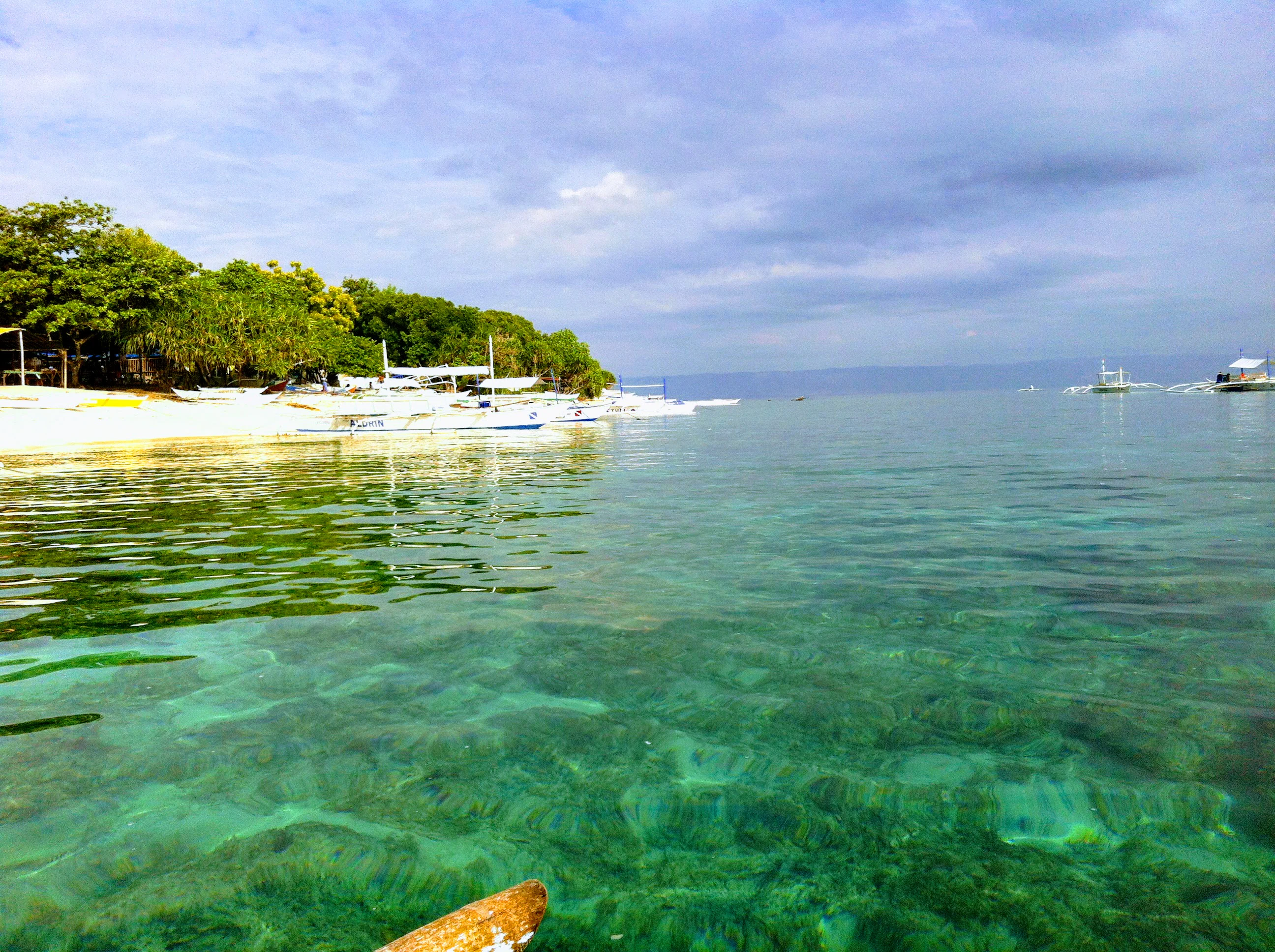
A view from the water looking toward a coastline with shallow coral reefs visible beneath the surface and outrigger boats moored near a sandy beach.
Clear turquoise waters at Balicasag Marine Sanctuary off the coast of Panglao.

Panglao Island Protected Seascape wildlife and species highlights

Panglao Island Protected Seascape is recognized internationally for the richness of its marine fauna, particularly its invertebrates. Research under the Panglao Marine Biodiversity Project documented roughly 250 new species of crustaceans and around 2,500 new species of mollusks in the waters around the island, a discovery that fundamentally reshaped understanding of marine biodiversity in the central Philippines and demonstrated that the area surpasses much larger marine regions in species counts.

Beyond invertebrates, the reef and coastal waters host a wide range of reef-associated fish species typical of healthy tropical coral ecosystems in the Visayas. Dolphins are also reported in waters around the island, contributing to the broader marine wildlife profile and supporting nature-based tourism such as dolphin watching. The combination of reef fish, marine invertebrates, and marine mammals makes the seascape an area of significant faunal diversity within the Philippine archipelago.

On land, wildlife is shaped by the island's karst terrain and limited freshwater resources, supporting adapted terrestrial species in forest and coastal vegetation communities. However, the wildlife identity of the protected area is dominated by its marine fauna, and the seascape's standing in regional biodiversity conservation rests primarily on the scientific importance of its underwater species records.

Panglao Island Protected Seascape conservation status and protection priorities

Panglao Island Protected Seascape holds significant conservation value because it protects one of the most species-rich marine areas identified in the Philippines and, by comparative measure, globally. The waters around Panglao and its offshore islets have been shown through the Panglao Marine Biodiversity Project to host more recorded marine biodiversity than much larger marine regions elsewhere, underscoring the global importance of conserving these reef systems.

Designation as a protected seascape under Republic Act No. 11038 in 2018 placed the area within the country's Expanded National Integrated Protected Areas System, giving it formal legal recognition alongside other nationally significant protected areas. This status supports coordinated management of reef habitats, fisheries resources, and coastal ecosystems, and provides a framework for regulating activities that could otherwise degrade the reef environment.

Conservation significance extends beyond species counts. Healthy coral reefs around Panglao contribute to coastal resilience, sustain local fisheries, and support a tourism economy that depends on intact marine habitats. Protecting these reef systems therefore serves multiple objectives: safeguarding marine biodiversity, sustaining livelihoods, and maintaining the natural capital that underpins one of the country's most recognized tropical destinations.

Panglao Island Protected Seascape cultural meaning and human context

Panglao has a layered cultural history that long predates its modern identity as a tourism and conservation destination. Before Spanish colonization, the island was part of the Kedatuan of Bo-ol, a precolonial Visayan polity engaged in regional trade with Chinese, Malay, Siamese, and Indonesian merchants. This trade-based heritage positioned the island within broader maritime networks of Southeast Asia.

Under Spanish influence, settlements such as Dauis on Panglao grew as administrative and population centers, with Spanish and Mexican families gradually assimilating into local communities. Today, Panglao's cultural identity reflects this mixed heritage, combined with the more recent transformation of the island into one of the Philippines' flagship tourism destinations, where local livelihoods, fishing traditions, and visitor-oriented economies coexist.

Top sights and standout views in Panglao Island Protected Seascape

The seascape's strongest highlight is the sheer concentration of marine biodiversity in a relatively small geographic area, documented through research that recorded hundreds of crustacean species and thousands of mollusk species around Panglao and its offshore islets. This makes the protected seascape a globally relevant reference point for tropical marine biodiversity in the central Philippines.

Equally distinctive is the seamless transition from a karst limestone island landscape to a productive tropical reef seascape, encompassing white sand beaches, reef-fringed offshore islets such as Balicasag, and clear Bohol Sea waters. The combination of scientifically significant marine life, accessible reef habitats, and a nationally recognized conservation designation defines the area's standout identity.

Best time to visit Panglao Island Protected Seascape

The seascape's tropical setting means conditions for experiencing its marine environment are generally favorable year round, with warm sea temperatures and clear coastal waters characteristic of the Bohol Sea. Many visitors time visits around periods of calmer seas and good underwater visibility, which enhance reef experiences, snorkeling, and diving around the offshore islets.

Seasonal variation in the Visayas is shaped more by rainfall than by temperature, with drier periods often associated with more settled coastal conditions and clearer reef views, while wetter months can bring reduced visibility but also a quieter, lush green character to the island landscape. Visitors interested in the seascape's marine biodiversity and reef scenery will generally find the dry-season months most conducive to fully appreciating the protected waters around Panglao.
Monthly climate preview

Long-term temperature and precipitation records across representative coordinate sampling

Panglao Island Protected Seascape Annual Climate Normals and Weather by Month

Representative coordinate sampling records mean monthly temperatures ranging between 26.48 degrees Celsius and 28.56 degrees Celsius alongside varying daily precipitation rates from 1991 to 2020. Reviewing the complete twelve-month climatology profile reveals comprehensive variations in baseline thermal and moisture averages.
Annual mean28 °C
26 °C29 °C
Jan26°
Feb26°
Mar27°
Apr28°
May29°
Jun28°
Jul28°
Aug28°
Sep28°
Oct28°
Nov28°
Dec27°
Warmest month
May

28.6 °C

Coolest month
January

26.5 °C

Wettest month
October

6.5 mm/day

Driest month
April

2.2 mm/day

Park location guide

Geography guide, regional context, and park location map for Panglao Island Protected Seascape

Panglao Island Protected Seascape park geography, regions, and map view in Philippines

Understand where Panglao Island Protected Seascape sits in Philippines through a broader geographic reading of the surrounding landscape, nearby location context, and its mapped position within the national park landscape.

How Panglao Island Protected Seascape fits into Philippines

The Philippines, officially the Republic of the Philippines, is an archipelagic nation in Southeast Asia comprising approximately 7,641 islands categorized into three main geographical divisions: Luzon, Visayas, and Mindanao. Located in the western Pacific Ocean, it shares maritime borders with Taiwan, Japan, Palau, Indonesia, Malaysia, Vietnam, and China. Manila serves as the capital city, while Quezon City is the most populated city, both within Metro Manila.

Wider geography shaping Panglao Island Protected Seascape in Philippines

The Philippines is an archipelagic nation in Southeast Asia, positioned in the western Pacific Ocean. Its islands are bounded by the South China Sea to the west, Philippine Sea to the east, and Celebes Sea to the south. The country shares maritime borders with Taiwan to the north, Japan to the northeast, Palau to the east and southeast, Indonesia to the south, Malaysia to the southwest, Vietnam to the west, and China to the northwest.

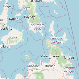
Map view of Panglao Island Protected Seascape

Use this park location map to pinpoint Panglao Island Protected Seascape in Philippines, understand its exact geographic position, and read its mapped placement within the surrounding landscape more clearly.

Pigeon | © OpenStreetMap contributors

Location context for Panglao Island Protected Seascape

Central Visayas

Visualizing the terrain, coral reef habitats, and coastal marine environment

Panglao Island Protected Seascape Photos, Landscapes, and Scenery

Examine detailed photographs of Panglao Island Protected Seascape to understand its unique limestone terrain and marine habitats. Visual documentation reveals the distinct geography of coralline reefs, clear coastal waters, and surrounding island ecosystems.

An aerial view of an island surrounded by deep blue ocean water, with a clear separation between the island landmass, shallow turquoise coral reefs, and the deep sea.

A wide-angle scenic view of a tropical white sand beach with palm trees along the shore, clear turquoise shallow water, and several traditional Filipino outrigger boats floating in the water.

A sandy tropical beach with a large leaning palm tree in the foreground, turquoise water with outrigger boats, and a bright blue sky with clouds.

A view from the water looking toward a coastline with shallow coral reefs visible beneath the surface and outrigger boats moored near a sandy beach.

Park atlas

Compare adjacent marine reserves and surrounding coastal landscapes in Central Visayas

Parks Near Panglao Island Protected Seascape and Regional Protected Areas

Browse other protected areas and marine reserves situated near Panglao Island Protected Seascape across the Bohol Sea region. Comparing these connected coastal zones provides broader geographic context for the high biodiversity found throughout Philippine island ecosystems.
Protected landscapeBohol
About 35 km away#1 closest

East

Rajah Sikatuna Protected Landscape: Mapping the Limestone Forest of Bohol, Philippines

A vital protected area of karst ridges and endemic forest habitats

Rajah Sikatuna Protected Landscape sits as a premier natural landmark in southern Bohol. This area is defined by its extensive karst topography, significant cave systems, and expansive limestone forests. It serves as an essential ecological anchor for the province, offering a unique perspective on the island's diverse upland geography and natural mountain systems.

Area
104.526 km²
Established
1987
IUCN
V
Relief
Mountain
National parkCebu
About 64 km away#2 closest

North

Guadalupe Mabugnao Mainit Hot Spring National Park: Protected Landscape and Watershed Geography

Explore hot springs, caves, and mapped terrain in Cebu.

Guadalupe Mabugnao Mainit Hot Spring National Park is a protected national park in Cebu, Philippines, recognized for its significant watershed function and unique natural features. Spanning forested highland terrain within the Mantalongon mountain range, the park protects natural hot springs, explored cave systems such as Cave Lorett, and river networks vital to local water supply. Its identity as a protected landscape offers rich opportunities for geographic exploration, mapping its boundaries, and understanding its role within the regional natural terrain and conservation efforts.

Area
0.575 km²
Established
1972
IUCN
V
Relief
Mountain
A watercolor painting showing a panoramic view of a lush wetland landscape with gentle green hills in the distance, a winding stream, and tall grasses and pink wildflowers in the foreground.
Wildlife reserveCentral Visayas
About 78 km away#3 closest

North

Olango Island Wildlife Sanctuary: Coastal Protected Area and Migratory Bird Habitat in Central Visayas

Explore the interconnected mudflats, reefs, and mangrove forest ecosystems

Olango Island Wildlife Sanctuary stands as a key protected landscape in the Central Visayas, defined by its vast tidal flats and critical role in international bird migration patterns. This site features a unique mosaic of salt marshes, seagrass beds, and coral reef systems that support diverse coastal life within the low-lying terrain of the Olango Island Group.

Area
10.3 km²
Established
1992
Relief
Lowland
Climate
Tropical
Marine protected areaVisayas
About 96 km away#4 closest

North

Tañon Strait Protected Seascape: Marine Geography and Protected Landscape Analysis

An expansive marine passage located within the central Visayas island group.

As the largest marine protected area in the Philippines, the Tañon Strait Protected Seascape represents a complex aquatic geography spanning 160 kilometres. Its protected waters serve as a vital corridor for marine biodiversity, linking the northern Visayan Sea to the southern Bohol Sea. This resource provides a detailed look at the strait's maritime boundaries, coastal ecosystems, and the distinct underwater terrain that defines this critical conservation zone.

Area
5,000 km²
Established
1998
IUCN
V
Scope
Marine
Wildlife reserveNegros Occidental
About 102 km away#5 closest

Northwest

Ilog-Hilabangan Watershed Forest Reserve: Geography and Protected Forest Boundaries

A vital wildlife reserve and watershed landscape in Negros Occidental

This protected area covers a vast expanse of lowland and montane tropical forest in the heart of Negros Island. By regulating the headwaters of major rivers and maintaining a secure habitat for threatened endemic species, the reserve acts as a fundamental component of the regional geography and biodiversity network in the Western Visayas.

Area
102.11 km²
Established
1990
Relief
Mountain
Scope
Terrestrial
A watercolor painting featuring soft green hills in the midground and faint, pale purple mountain silhouettes in the background against a white backdrop.
National parkNegros Occidental
About 118 km away#6 closest

Northwest

Mount Kanlaon Natural Park: Mapping the Volcanic Heart of Negros Island Protected Lands

A comprehensive geographic overview of volcanic terrain and rainforest habitats.

Mount Kanlaon Natural Park protects a defining massif in the Western Visayas, blending active volcanic features with some of the most intact tropical rainforests remaining on Negros Island. This geographic record maps the transition from steep, high-elevation ridges to lower-altitude forest boundaries, providing context on its importance as a refuge for threatened endemic wildlife and a significant center for regional biodiversity conservation.

Area
248.54 km²
Established
1934
Relief
Mountain
Scope
Terrestrial
A soft watercolor painting of a coastal landscape with green rolling hills, distant faint mountains, and light water reflections.
Protected landscapeLeyte
About 137 km away#7 closest

Northeast

Cuatro Islas Protected Landscape/Seascape: Leyte Marine and Island Geography Exploration

Detailed protected area atlas for the Camotes Sea island group

The Cuatro Islas Protected Landscape/Seascape is a notable Philippine conservation zone consisting of four distinct islands including Apid, Mahaba, Digyo, and Himokilan. This geographic profile details the diverse terrain, ranging from uplifted former coral reefs to coral sand islets, while providing a clear understanding of the surrounding marine ecosystem and its role in regional conservation.

Area
125 km²
Established
2000
Scope
Mixed
National parkPhilippines
About 176 km away#8 closest

Northeast

Kuapnit Balinsasayao National Park: Philippines Old-Growth Forest and Endemic Wildlife Atlas

Explore protected landscape boundaries and mountainous terrain on Leyte Island.

Kuapnit Balinsasayao National Park stands as a key protected area within the Philippines, distinguished by its mature old-growth forests and its critical role in conserving endemic bird species unique to the Eastern Visayas. Located on Leyte Island within the mountainous terrain of the Anonang-Lobi Mountain Range, the park's protected landscape identity is central to understanding its geographic significance. This park offers a valuable entry point for exploring the mapped natural features and conservation importance of protected areas across the Philippine archipelago.

Area
3.64 km²
Established
1937
IUCN
V
Relief
Mountain

Common questions about visiting, size, designation, and location context for Panglao Island Protected Seascape

Panglao Island Protected Seascape FAQs for park facts, access, geography, and protected area context

Find quick answers about Panglao Island Protected Seascape, including protected-area facts, park geography, trail and visitor context, and how the park fits into its surrounding country and regional landscape.
MoriAtlas Explorer

Continue Your Protected Areas Search Across the Global Atlas

Deepen your exploration by continuing the structured search for national parks and protected areas worldwide. Utilize the comprehensive filtering capabilities to compare different conservation landscapes and refine your understanding of global park geography. Discover more about the distribution and characteristics of protected natural areas.

Global natural geography