Mori Atlas logo
National parkPantuwaraya Lake National Park

Explore the mapped boundaries and natural terrain of this national park in Lanao del Sur.

Pantuwaraya Lake National Park: Protected Landscape Atlas and Geographic Context

Pantuwaraya Lake National Park stands as a designated national park offering a distinct protected landscape within the Philippines. This atlas-focused entry provides insight into its geographic scope, mapped boundaries, and regional setting in Lanao del Sur. Understand the park's role in the broader geography and explore its natural terrain through detailed mapping and structured data.

LakeProtected AreaWatershedHydroelectricMindanaoLanao del Sur

Pantuwaraya Lake National Park

National park

Park overview

Structured park overview, official facts, and landscape profile for Pantuwaraya Lake National Park

Pantuwaraya Lake National Park park facts, protected area profile, and essential visitor context
Review the core facts for Pantuwaraya Lake National Park, including designation, size, terrain, visitor scale, habitats, and operating context in one park-focused overview.

About Pantuwaraya Lake National Park

Pantuwaraya Lake National Park represents a significant conservation designation in the Philippines despite its relatively small area. The protected area was established in 1965 under Republic Act No. 4190, making it one of the earlier national park designations in the country. The park centers on Lake Pantao Raya, an inland water body that forms part of the larger hydrological network draining from Lake Lanao in Lanao del Sur province.

The strategic importance of this protected area stems from its position within the Lake Lanao-Agus River Watershed Area, which serves as the primary water source for the Agus hydroelectric complex. This hydroelectric system provides approximately 70 percent of Mindanao's electrical power, making the watershed areas feeding it essential infrastructure for the island's energy security. The protected status of Lake Pantao Raya and its surroundings helps maintain the ecological integrity of this critical watershed.

Geographically, the park is situated in a region characterized by numerous lakes and reservoirs. The Iligan-Marawi road, which provides access to the park, passes through a landscape dotted with significant water bodies including Basak Lake, Laguna de Calaganan, Talao Lake, and Agus Lake. This clustering of aquatic environments reflects the hydrological richness of the Lanao del Sur region and underscores the importance of protecting individual water bodies like Pantao Raya within the broader watershed context.

Quick facts and research context for Pantuwaraya Lake National Park

Pantuwaraya Lake National Park is a Category V protected landscape in the Philippines, located in Lanao del Sur on Mindanao island. The park was established on May 5, 1965, and covers 20 hectares centered on Lake Pantao Raya. It is managed by the Department of Environment and Natural Resources and lies within the Lake Lanao-Agus River Watershed Area, which is critical for both water supply and hydroelectric power generation. The park is situated in Saguiaran municipality, barangay Pantao Raya, and is accessible via the Iligan-Marawi road.

Park context

Deeper park guide and search-rich context for Pantuwaraya Lake National Park

Pantuwaraya Lake National Park history, landscape, wildlife, and travel context
Explore Pantuwaraya Lake National Park through its history, landscape character, ecosystems, wildlife, conservation priorities, cultural context, and seasonal travel timing in a structured park guide built for atlas discovery and search intent.

Why Pantuwaraya Lake National Park stands out

Pantuwaraya Lake National Park is best known for its role as a critical component of the Lake Lanao-Agus River Watershed system. The park is recognized primarily for its environmental importance in supporting the hydroelectric infrastructure that powers much of Mindanao, rather than for recreational tourism or dramatic scenic landscapes. The lake and surrounding protected area serve as a hydrological buffer zone that helps maintain water quality and flow into the Agus River, which feeds the hydroelectric plants supplying electricity to the region.

Pantuwaraya Lake National Park history and protected-area timeline

Pantuwaraya Lake National Park was established on May 5, 1965, through the passage of Republic Act No. 4190. This legislation designated the area encompassing Lake Pantao Raya and its surrounding terrain as a national park, recognizing its environmental and ecological significance within the broader Mindanao region. The declaration came during a period when the Philippines was expanding its protected area network, with numerous parks being established across the country's diverse ecological zones.

The establishment of the park reflected growing awareness in the 1960s of the need to preserve critical watershed areas, particularly those associated with important hydrological features like Lake Lanao and its tributary lakes. The Act designated the area under the jurisdiction of what is now the Department of Environment and Natural Resources, which continues to oversee the park's management. The protected area was subsequently categorized as an IUCN Category V protected landscape, reflecting its role as an area where nature conservation is integrated with sustainable land use and human activities.

Pantuwaraya Lake National Park landscape and geographic character

The landscape of Pantuwaraya Lake National Park is characterized by a central lake surrounded by terrestrial terrain in the Lake Lanao basin of Lanao del Sur. Lake Pantao Raya sits within a valley setting, with the surrounding land generally flat to gently rolling, typical of the lowland areas surrounding Mindanao's major lakes. The area falls within the broader Lake Lanao-Agus River watershed, which drains from the higher elevations of the Lanao plateau toward the coast.

The terrestrial portions of the park consist of the buffer zones surrounding the lake itself, providing a transition between the aquatic environment and the surrounding agricultural and settlement areas. The regional landscape features numerous other lakes and reservoirs, creating a distinctive hydrological mosaic that distinguishes this part of Lanao del Sur from other regions of Mindanao.

Pantuwaraya Lake National Park ecosystems, habitats, and plant life

The ecological character of Pantuwaraya Lake National Park is defined by its position within the Lake Lanao-Agus River Watershed Area, one of the most important hydrological systems in Mindanao. The lake and its surrounding buffer zones function as a natural water regulation system, helping to maintain water quality and flow patterns that support both downstream hydroelectric operations and broader ecological functions. The watershed supports diverse habitats ranging from aquatic environments to surrounding grasslands and cultivated areas.

The protection of this watershed area is particularly significant given its role in supporting the Agus hydroelectric complex. Maintaining the ecological integrity of lakes like Pantao Raya helps ensure consistent water flow and quality for power generation, while also preserving the broader ecological services provided by healthy watershed ecosystems. This integration of conservation with infrastructure support represents a key dimension of the park's environmental significance.

Pantuwaraya Lake National Park wildlife and species highlights

The Wikipedia source provides limited specific information about wildlife within Pantuwaraya Lake National Park. The park's aquatic environment would be expected to support fish populations and waterbird species typical of Mindanao's lakes, while the surrounding terrestrial areas likely support common species found in the Lake Lanao region. However, without more detailed source material, it would be speculative to enumerate specific wildlife species present in the protected area.

Pantuwaraya Lake National Park conservation status and protection priorities

Pantuwaraya Lake National Park holds significant conservation value primarily due to its position within the Lake Lanao-Agus River Watershed Area. This watershed system is critical for maintaining the water supply that powers the Agus Hydroelectric Power Plant, which provides approximately 70 percent of Mindanao's electricity. The protected status of the lake and surrounding area helps preserve the ecological integrity of this vital watershed, ensuring continued water quality and flow for both energy production and broader environmental purposes.

The park's IUCN Category V designation reflects its role as a protected landscape where nature conservation is integrated with sustainable human activities. This classification acknowledges that the area's value lies not only in preserving natural habitats but also in maintaining the functional relationship between the lake ecosystem and the human communities and infrastructure that depend on it. Conservation efforts at the site focus on maintaining watershed health and preventing degradation of the lake's water quality.

Pantuwaraya Lake National Park cultural meaning and human context

Pantuwaraya Lake National Park is located in Lanao del Sur, a province with a distinctive cultural identity as the heartland of the Maranao people in the Philippines. The municipality of Saguiaran, where the park is situated, lies within this Muslim-majority region that has its own unique traditions, governance structures, and relationship with the land. The lake itself is named Pantao Raya, a name reflecting the local linguistic heritage of the area.

The broader Lake Lanao region has historical significance as the setting for the Battle of Marawi in 2017, though Pantuwaraya Lake itself is located some distance from Marawi city. The watershed areas of this region have long supported both agricultural and fishing communities, and the lakes in this part of Lanao del Sur remain important to local livelihoods and cultural practices.

Top sights and standout views in Pantuwaraya Lake National Park

The standout feature of Pantuwaraya Lake National Park is its critical role in the hydroelectric infrastructure of Mindanao. While the park covers only 20 hectares, the watershed it helps protect supplies water to the Agus hydroelectric system that provides approximately 70 percent of the island's electricity. This makes the small lake and its protected surroundings disproportionately important to regional infrastructure. The park also represents one of the protected areas in Lanao del Sur that helps preserve the network of lakes and reservoirs characteristic of this part of Mindanao.

Best time to visit Pantuwaraya Lake National Park

The Wikipedia source does not provide specific seasonal guidance for visiting Pantuwaraya Lake National Park. The park's location in Lanao del Sur means it experiences a tropical climate typical of Mindanao, with generally warm temperatures year-round. Visitors interested in exploring the protected area should consult current local guidance for the best conditions, as the source material does not contain detailed visit timing information.

Park location guide

Geography guide, regional context, and park location map for Pantuwaraya Lake National Park

Pantuwaraya Lake National Park park geography, regions, and map view in Philippines
Understand where Pantuwaraya Lake National Park sits in Philippines through a broader geographic reading of the surrounding landscape, nearby location context, and its mapped position within the national park landscape.

How Pantuwaraya Lake National Park fits into Philippines

The Philippines, officially the Republic of the Philippines, is an archipelagic nation in Southeast Asia comprising approximately 7,641 islands categorized into three main geographical divisions: Luzon, Visayas, and Mindanao. Located in the western Pacific Ocean, it shares maritime borders with Taiwan, Japan, Palau, Indonesia, Malaysia, Vietnam, and China. Manila serves as the capital city, while Quezon City is the most populated city, both within Metro Manila.

Wider geography shaping Pantuwaraya Lake National Park in Philippines

The Philippines is an archipelagic nation in Southeast Asia, positioned in the western Pacific Ocean. Its islands are bounded by the South China Sea to the west, Philippine Sea to the east, and Celebes Sea to the south. The country shares maritime borders with Taiwan to the north, Japan to the northeast, Palau to the east and southeast, Indonesia to the south, Malaysia to the southwest, Vietnam to the west, and China to the northwest.

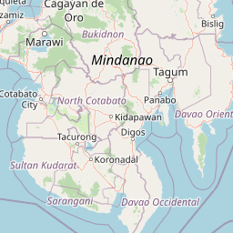
Map view of Pantuwaraya Lake National Park

Use this park location map to pinpoint Pantuwaraya Lake National Park in Philippines, understand its exact geographic position, and read its mapped placement within the surrounding landscape more clearly.

Pigeon | © OpenStreetMap contributors

Location context for Pantuwaraya Lake National Park

Lanao del Sur
Park atlas

Browse the mapped geography of protected landscapes across Lanao del Sur and wider Mindanao.

Explore National Parks and Protected Areas Near Pantuwaraya Lake National Park
Continue your exploration of Pantuwaraya Lake National Park by discovering other national parks and protected areas across Lanao del Sur and the broader Mindanao region. Comparing these protected landscapes helps trace the hydrological network of significant lakes and watersheds that define this crucial ecological zone.
National parkLanao del Sur

Lake Butig National Park: National Park Atlas and Geographic Discovery in Lanao del Sur

Discover its mapped boundaries and regional landscape context.

Lake Butig National Park is a protected national park in the Philippines, located within Lanao del Sur. This entry provides specific geographic information and supports atlas exploration by detailing the park's mapped boundaries and its place within the regional landscape. Understand the terrain and protected area context crucial for geographic study and understanding Philippine natural landscapes.

Area
0.68 km²
Established
1965
IUCN
V
Relief
Mountain
National parkLanao del Sur

Salikata National Park: Explore Philippines National Park Geography

Mapped protected area boundaries and regional context.

Investigate Salikata National Park, a key protected area designated as a national park within Lanao del Sur, Philippines. This detailed view provides essential context for understanding its mapped boundaries, its place in the regional geography, and its significance as a protected landscape. Discover the unique geographic attributes that define Salikata National Park for atlas-based exploration.

Established
1965
IUCN
V
Relief
Mountain
Climate
Tropical
National parkLanao del Sur

Sacred Mountain National Park National Park: Detailed Geographic and Protected Landscape Context

Mapped boundaries and regional geography for Sacred Mountain National Park.

Sacred Mountain National Park, a significant national park in Lanao del Sur, offers a distinct protected landscape for atlas-driven discovery. This detailed entry provides insight into its geographic scope and mapped presence, allowing for a deeper understanding of its role within the region. Explore the specific natural terrain and protected area features that define Sacred Mountain National Park, grounded in factual geographic data.

Area
0.94 km²
Established
1965
IUCN
V
Relief
Mountain
National parkMaguindanao del Norte

Mado Hot Spring National Park: Protected Geothermal Landscape in Maguindanao del Norte

Explore its therapeutic hot springs and mapped boundaries

Mado Hot Spring National Park, located in Maguindanao del Norte, Philippines, is a protected area defined by its geothermal features and therapeutic hot springs. This national park, established early in the Philippines' conservation history, offers a unique landscape centered around a warm mineral-rich natural pool. Delve into the geographic context and protected area identity of this distinctive site, understanding its role within the region's natural heritage.

Area
0.48 km²
Established
1939
IUCN
II
Scope
Terrestrial
National parkCebu

Guadalupe Mabugnao Mainit Hot Spring National Park: Protected Landscape and Watershed Geography

Explore hot springs, caves, and mapped terrain in Cebu.

Guadalupe Mabugnao Mainit Hot Spring National Park is a protected national park in Cebu, Philippines, recognized for its significant watershed function and unique natural features. Spanning forested highland terrain within the Mantalongon mountain range, the park protects natural hot springs, explored cave systems such as Cave Lorett, and river networks vital to local water supply. Its identity as a protected landscape offers rich opportunities for geographic exploration, mapping its boundaries, and understanding its role within the regional natural terrain and conservation efforts.

Area
0.575 km²
Established
1972
IUCN
V
Relief
Mountain
National parkPhilippines

Kuapnit Balinsasayao National Park: Philippines Old-Growth Forest and Endemic Wildlife Atlas

Explore protected landscape boundaries and mountainous terrain on Leyte Island.

Kuapnit Balinsasayao National Park stands as a key protected area within the Philippines, distinguished by its mature old-growth forests and its critical role in conserving endemic bird species unique to the Eastern Visayas. Located on Leyte Island within the mountainous terrain of the Anonang-Lobi Mountain Range, the park's protected landscape identity is central to understanding its geographic significance. This park offers a valuable entry point for exploring the mapped natural features and conservation importance of protected areas across the Philippine archipelago.

Area
3.64 km²
Established
1937
IUCN
V
Relief
Mountain
National parkPalo

MacArthur Landing Memorial National Park: Protected Area Geography & Map Context

Explore the mapped boundaries of this national park in Palo, Philippines.

This entry details MacArthur Landing Memorial National Park, a protected national park located near Palo, Philippines. It focuses on its identity as a mapped landscape and a distinct protected area, offering insights into its geographic context and atlas presence. Understanding this park involves exploring its mapped boundaries and its contribution to the regional protected area landscape, providing a factual basis for geographic discovery.

Area
0.068 km²
Established
1977
Relief
Lowland
Climate
Tropical
National parkPhilippines

Bulabog Putian National Park: Philippines National Park Geographic Context and Mapped Boundaries

Discover the protected landscape identity and regional atlas significance.

Bulabog Putian National Park stands as a designated national park in the Philippines, offering valuable insights for geographic and protected-area exploration. Users can understand its specific location and mapped presence within the country's natural landscape, contributing to a structured atlas of conservation areas. This entry focuses on the park's identity and geographic setting for informed discovery.

Area
8.543 km²
Established
1961
IUCN
V
Relief
Mountain

Common questions about visiting, size, designation, and location context for Pantuwaraya Lake National Park

Pantuwaraya Lake National Park FAQs for park facts, access, geography, and protected area context
Find quick answers about Pantuwaraya Lake National Park, including protected-area facts, park geography, trail and visitor context, and how the park fits into its surrounding country and regional landscape.
MoriAtlas Explorer

Continue Your Protected Areas Search Across the Global Atlas

Deepen your exploration by continuing the structured search for national parks and protected areas worldwide. Utilize the comprehensive filtering capabilities to compare different conservation landscapes and refine your understanding of global park geography. Discover more about the distribution and characteristics of protected natural areas.

Global natural geography