
Mori Atlas logo
Protected landscapeParc naturel des Plaines de l'Escaut

Understanding the mapped boundaries and natural terrain of the Scheldt river basin region.

Parc naturel des Plaines de l'Escaut: A Regional Protected Landscape in Hainaut, Belgium

The Parc naturel des Plaines de l'Escaut encompasses a significant protected landscape within the Walloon region of Belgium. This territory includes a dense network of canals, agricultural lowlands, and diverse natural cores like the Harchies marshes and Bon-Secours forest. As part of a transboundary network along the Scheldt valley, the area preserves critical ecological segments fragmented by modern infrastructure, creating a distinct blend of rural heritage, water management, and conservation.

lowland landscapeScheldt valleyriver basinmarshlandwetlandsdeciduous forest
A digital illustration showing a winding river in the foreground leading toward a waterfall cascading down a large mountain valley with coniferous trees.

Parc naturel des Plaines de l'Escaut

Protected landscape

Park overview

Structured park overview, official facts, and landscape profile for Parc naturel des Plaines de l'Escaut

Parc naturel des Plaines de l'Escaut park facts, protected area profile, and essential visitor context

Review the core facts for Parc naturel des Plaines de l'Escaut, including designation, size, terrain, visitor scale, habitats, and operating context in one park-focused overview.

About Parc naturel des Plaines de l'Escaut

The Parc naturel des Plaines de l'Escaut occupies a broad swathe of the western Hainaut province, defined by the river basin of the Scheldt. Its territory surrounds the historic city of Tournai and extends westward toward the French border, eastward toward the surroundings of Mons, and southward toward the agricultural heart of western Wallonia. The 2020 enlargement brought the total area to roughly 465 square kilometers, distributed across the communes of Rumes, Brunehaut, Antoing, Péruwelz, Beloeil, Bernissart and the expanded municipality of Tournai.

Although heavily shaped by centuries of agriculture, industry, wartime damage and modern infrastructure, the park retains identifiable natural cores. Forests such as the Bon-Secours and Stambruges woodlands, marshes such as the Harchies ponds, and a network of canals and watercourses give the territory a clearly structured rural character. The landscape also carries strong heritage elements, most visibly the Castle of Beloeil and other chateaux that punctuate the plain.

From a governance perspective, the park is run by a management commission drawn from local communes, the Province of Hainaut, the Walloon Region's Nature and Forest Department and Spatial Planning directorate, farming representatives, naturalists, rural organizations and local water management bodies (watringues). The commission oversees a management plan that combines ecological restoration, environmental protection, agro-environmental support, public education, sustainable tourism and rural development, supported by a multidisciplinary technical team.

The park's identity is not only Belgian but also transboundary: with its French counterpart, the Scarpe-Escaut Regional Nature Park established in 1968, it forms the Parc Transfrontalier du Hainaut, a combined protected landscape that bridges Wallonia and northern France along the shared Scheldt valley.

Quick facts and research context for Parc naturel des Plaines de l'Escaut

The Parc naturel des Plaines de l'Escaut was officially created in June 1996 in the Walloon Region of Belgium. Following a 2020 extension, its territory covers approximately 465 square kilometers and is home to over one hundred thousand residents across seven communes.

It is classified under IUCN Category V (protected landscape or seascape) and several of its core natural areas are designated under the Natura 2000 network. The park forms, with the French Scarpe-Escaut Regional Nature Park, a transboundary Hainaut nature park.

Protection and recognition

Documented terrestrial protection history and transboundary management scope

Parc naturel des Plaines de l'Escaut Protection Status and Recognition Data

Terrestrial protection status records for Parc naturel des Plaines de l'Escaut outline documented designation history established in 2020. Transboundary parameters provide essential conservation context for evaluating regional protected area management frameworks.

Protection details

Protection scope
Terrestrial
Designated year
2020
Transboundary protection
Yes
WDPA ID
386129
Park context

Deeper park guide and search-rich context for Parc naturel des Plaines de l'Escaut

Parc naturel des Plaines de l'Escaut history, landscape, wildlife, and travel context

Explore Parc naturel des Plaines de l'Escaut through its history, landscape character, ecosystems, wildlife, conservation priorities, cultural context, and seasonal travel timing in a structured park guide built for atlas discovery and search intent.

Why Parc naturel des Plaines de l'Escaut stands out

The park is best known for its lowland Scheldt valley landscape, in which historic castles, tree-lined canals, agricultural plains and patches of woodland coexist within a heavily humanized region. The Harchies marshes, the Stambruges forest with its Mer de Sable heath area, and the Bon-Secours forest are among its most recognizable natural features. It is also distinguished by its cross-border identity: the Belgian park and the French Scarpe-Escaut Regional Nature Park together form the transboundary Hainaut park, making it a notable example of international landscape cooperation in northwestern Europe.
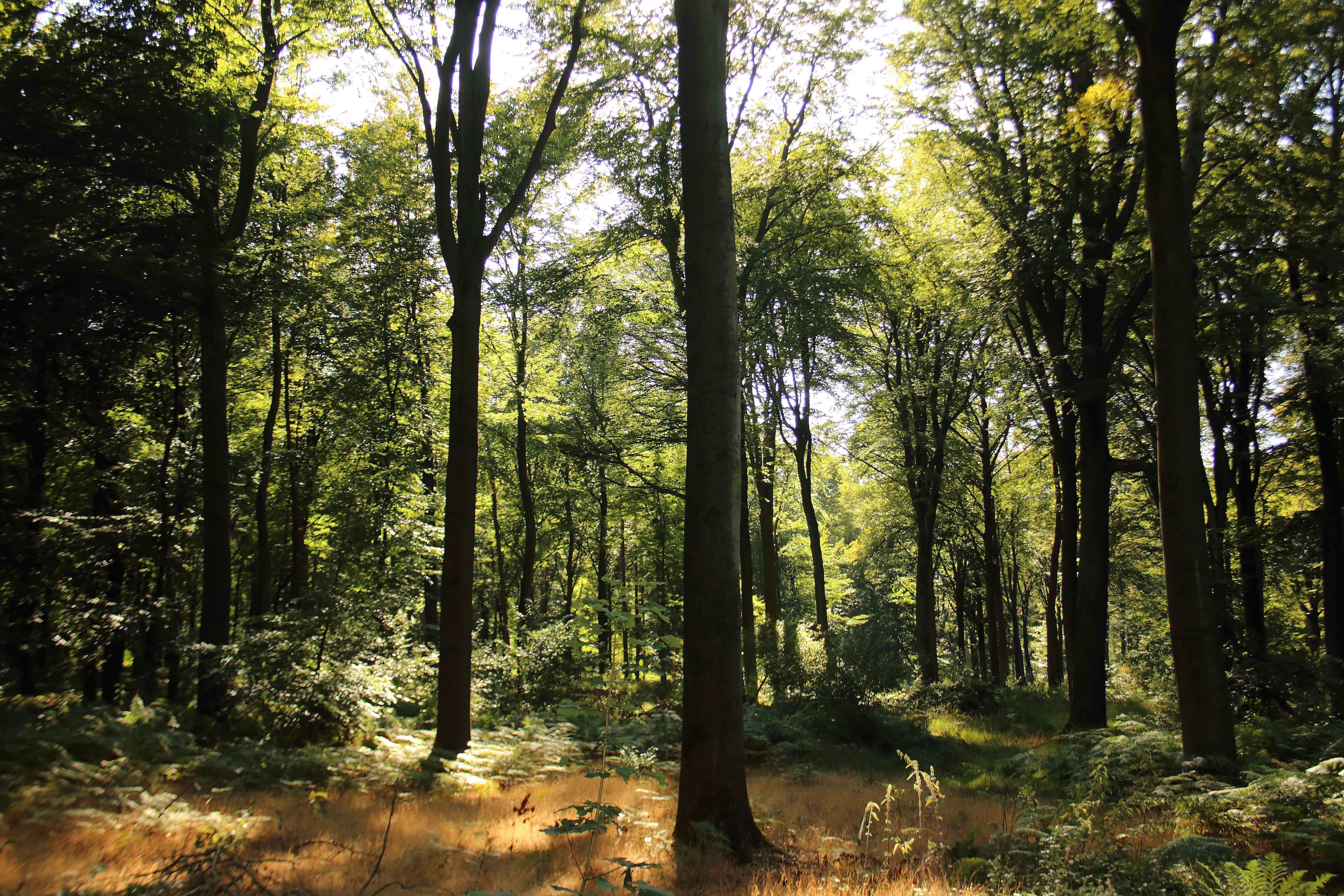
A bright, sunlit deciduous forest scene with tall tree trunks, a leafy green canopy, and a forest floor covered in golden-brown grasses and ferns.
Sunlight filtering through the canopy in the Forest of Stambruges.

Parc naturel des Plaines de l'Escaut history and protected-area timeline

The Parc naturel des Plaines de l'Escaut was officially established in June 1996, as part of the Walloon Region's program for recognizing nature parks in densely populated and culturally rich landscapes. Its initial extent covered roughly 26,649 hectares across six communes and about 37 former villages, with an initial population near 60,000 inhabitants.

In 2020, the park underwent a significant territorial extension, growing to roughly 46,449 hectares and increasing its resident population to over 100,000 people. The enlargement added a seventh commune and brought the total of historical villages within its boundaries to approximately 66, reflecting the park's role as a framework for a culturally and administratively complex rural region.

Beyond its institutional creation, the park's history is shaped by landscape legacies of industrial activity, wartime scarring and intensive agriculture, alongside persistent efforts to maintain ecological connectivity. Its close relationship with the older French Parc naturel régional Scarpe-Escaut, founded in 1968, gave rise to the cross-border Parc naturel transfrontalier du Hainaut, embedding the Belgian park within a longer tradition of transnational nature park cooperation in the Franco-Belgian borderland.

Parc naturel des Plaines de l'Escaut landscape and geographic character

The park lies in the gently undulating lowlands of the Scheldt basin, where broad agricultural plains alternate with canals, patches of woodland, wetlands, meadows and small villages. The terrain has no dramatic relief; instead it offers a layered, horizontal landscape typical of northwestern European rural regions, with regularly spaced tree lines, pollarded willows and water channels shaping visual rhythm.

Canals such as the Pommeroeul-Antoing canal cut across the territory and, together with roads, motorways and high-speed rail lines, contribute to a pronounced ecological fragmentation of the otherwise rural setting. Despite this fragmentation, the park retains coherent landscape units, including the marshland around Harchies, the wooded ridge of Stambruges with its heath openings known as the Mer de Sable, and the extensive Bon-Secours forest domain.

Heritage features strongly modulate the landscape: castles such as the Castle of Beloeil, surrounded by gardens and parkland, anchor large parts of the territory and reinforce the park's character as a meeting point of cultivated countryside, water management infrastructure and historical estate landscapes.
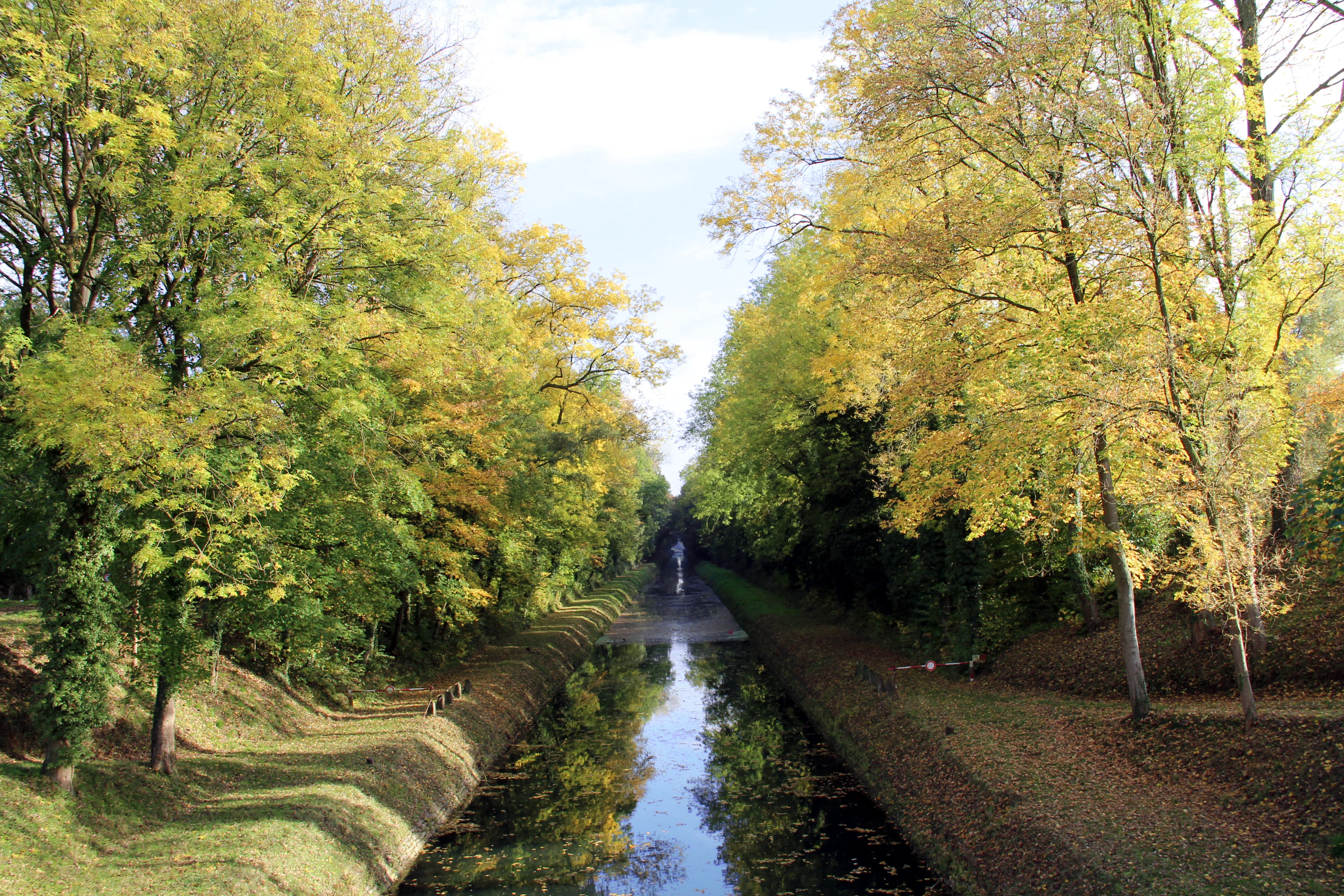
A narrow canal stretches into the distance, framed on both sides by a dense row of trees with yellow and green autumn leaves.
A tranquil reach of the historic Pommeroeul-Peronnes Canal, known locally as the trench, surrounded by autumn foliage in Maubray.

Parc naturel des Plaines de l'Escaut ecosystems, habitats, and plant life

Ecologically, the park functions as a refuge and stepping stone in a heavily transformed lowland region. Several of its core zones are designated under the Natura 2000 network, including the Bon-Secours forest, the Stambruges forest and the Harchies marshes, indicating their recognized value for European biodiversity conservation.

Habitats within the park range from mixed deciduous woodland and heath-like sandy openings (the Mer de Sable at Stambruges) to marshy wetlands, ponds, meadows with pollarded willows, agricultural fields and small watercourses. The combination of forest, open heath and wetland gives the territory a notable ecological diversity relative to its predominantly agricultural surroundings.

The park's natural cores are framed within the pan-European ecological network, and management efforts focus on ecological restoration, connectivity and agro-environmental measures that aim to soften the impacts of fragmentation caused by infrastructure, agriculture and past industrial and wartime activity.
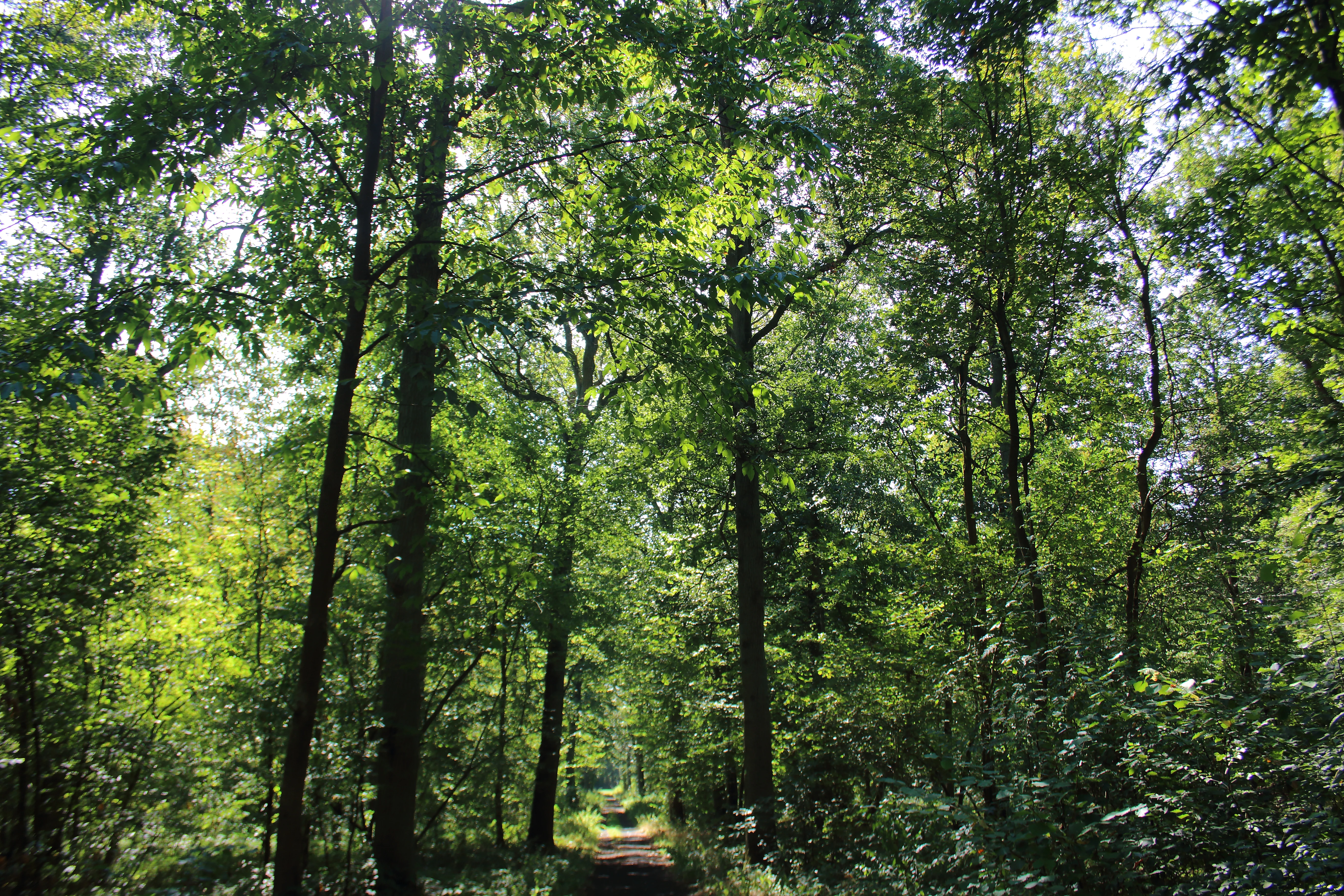
A narrow dirt trail leads into a sun-dappled, mature deciduous forest in the Parc naturel des Plaines de l'Escaut.
A shaded pathway winding through the dense canopy of the Bon-Secours Forest.

Parc naturel des Plaines de l'Escaut wildlife and species highlights

The mixture of woodland, marsh and open heath within the park supports a varied fauna typical of northwestern European lowlands. The Harchies marshes, in particular, are recognized as a major wetland area in the Scheldt valley and host a rich community of waterbirds and other wetland-associated species.

Forested zones such as the Bon-Secours and Stambruges woodlands provide habitat for typical woodland birds, mammals and invertebrates, while patches of heath and sandy openings contribute to specialized habitat niches. Meadows, hedgerows and watercourses associated with traditional rural land use add further structural diversity for wildlife across the park.
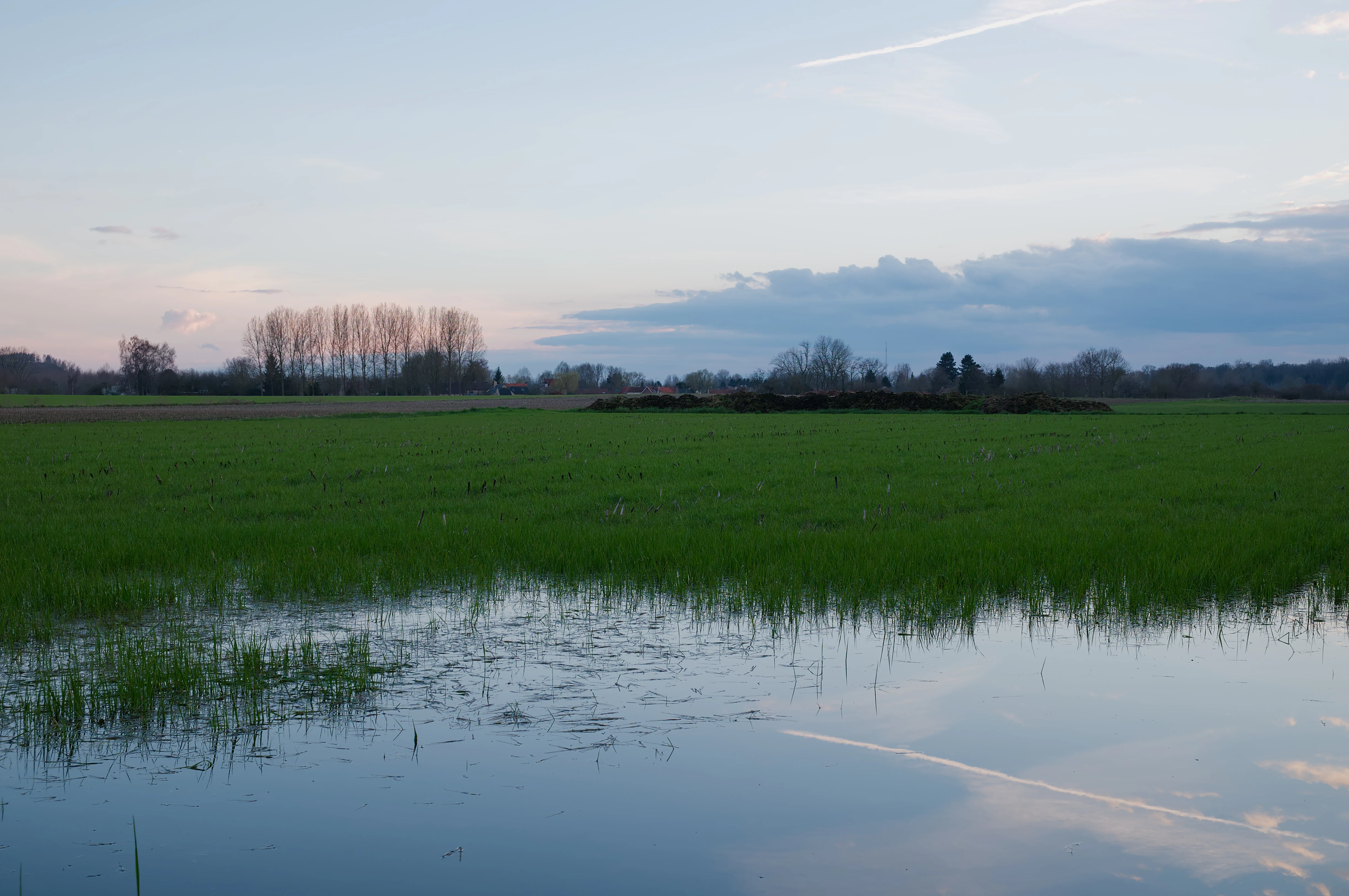
A wide, low-angle view of a flooded grassy field at dusk with soft light reflecting off the water surface, and distant trees on the horizon.
A flooded meadow in the Plaines de l'Escaut, capturing the quiet character of the Scheldt river basin at dusk.

Parc naturel des Plaines de l'Escaut conservation status and protection priorities

The Parc naturel des Plaines de l'Escaut is classified under IUCN Category V as a protected landscape, reflecting its emphasis on maintaining a working rural environment shaped by centuries of human activity rather than wilderness preservation alone. Multiple Natura 2000 designations within its boundaries underline its importance within the European conservation framework.

Conservation work is delivered through a management plan that combines habitat restoration, ecological connectivity, agro-environmental measures, environmental education and rural development. The park's commission includes representatives of nature NGOs such as Natagora (RNOB) and the Cercles des naturalistes de Belgique, giving civil society a direct role in shaping conservation priorities.

Its cross-border integration with the French Scarpe-Escaut Regional Nature Park amplifies its conservation significance, allowing coordinated management of habitats and species along the Scheldt valley across national boundaries and reinforcing its role in the pan-European ecological network.

Parc naturel des Plaines de l'Escaut cultural meaning and human context

The park overlaps with a densely settled rural region whose village fabric predates modern administrative boundaries. The 2020 extension alone brought the total of former villages within its limits to around 66, reflecting a long history of small, connected rural communities in western Hainaut.

Heritage landmarks, especially the Castle of Beloeil and other chateaux, are central to local identity and form part of the park's protected landscape. Local water management bodies (watringues), agricultural traditions, and the presence of community groups such as Lesdain nurserymen and rural foundations all contribute to a strong local cultural fabric tied to the land.

The park's profile is also transnational, sharing its identity with the French Parc naturel régional Scarpe-Escaut and the broader Parc naturel transfrontalier du Hainaut, which embodies a shared Franco-Belgian approach to rural landscape stewardship.

Top sights and standout views in Parc naturel des Plaines de l'Escaut

Among the park's strongest features are the Harchies marshes, the Bon-Secours forest, and the Stambruges forest with its Mer de Sable heath area, each recognized as a Natura 2000 site and central to the park's ecological identity. The Castle of Beloeil and other heritage estates punctuate the landscape and connect ecological protection with cultural heritage.

The park also stands out for its 2020 territorial expansion and its role as the Belgian half of the transboundary Hainaut nature park, making it a notable example of cross-border landscape cooperation along the Scheldt valley.

Best time to visit Parc naturel des Plaines de l'Escaut

The park's landscapes of woodland, marsh, heath and agricultural plain shift character with the seasons. Spring and early summer bring active birdlife to the Harchies marshes and renewed greenery across the meadows and canal-side willows, while the broadleaf forests of Bon-Secours and Stambruges are most visually expressive in autumn when foliage turns color.

Mild weather in late spring and early autumn generally suits walking the marked Route Paysagère and visiting the 'Escale forestière' visitor center with its treetop walkway (promenoir des cimes) at the Bon-Secours forest, while winter offers a quieter atmosphere to appreciate the open lowland scenery and castle grounds.


Monthly climate preview

Long-term representative monthly temperature and precipitation rhythm in Hainaut

Parc Naturel des Plaines de l'Escaut Climate Normals and Annual Weather Patterns

Representative coordinate measurements record monthly mean temperatures ranging from 2.48 °C to 18.07 °C alongside consistent precipitation patterns. Analyzing the complete twelve-month climatology profile reveals comprehensive variations across the protected terrain.
Annual mean10 °C
2 °C18 °C
Jan
Feb
Mar
Apr
May13°
Jun16°
Jul18°
Aug18°
Sep15°
Oct11°
Nov
Dec
Warmest month
July

18.1 °C

Coolest month
January

2.5 °C

Wettest month
December

2.6 mm/day

Driest month
April

1.5 mm/day

Park location guide

Geography guide, regional context, and park location map for Parc naturel des Plaines de l'Escaut

Parc naturel des Plaines de l'Escaut park geography, regions, and map view in Belgium

Understand where Parc naturel des Plaines de l'Escaut sits in Belgium through a broader geographic reading of the surrounding landscape, nearby location context, and its mapped position within the national park landscape.

How Parc naturel des Plaines de l'Escaut fits into Belgium

Belgium is a parliamentary constitutional monarchy and federal state in Northwestern Europe. Located in the Low Countries, it borders the Netherlands, Germany, Luxembourg, France, and the North Sea. The country has three autonomous regions and three official languages, with Brussels as both the capital and largest city. Belgium is a founding member of the European Union and hosts its de facto capital in Brussels.

Wider geography shaping Parc naturel des Plaines de l'Escaut in Belgium

Belgium occupies a coastal lowland region in Northwestern Europe known as the Low Countries. It is bordered by the Netherlands to the north, Germany to the east, Luxembourg to the southeast, France to the south, and the North Sea to the west. The country also shares a maritime boundary with the United Kingdom to the northwest.

Map view of Parc naturel des Plaines de l'Escaut

Use this park location map to pinpoint Parc naturel des Plaines de l'Escaut in Belgium, understand its exact geographic position, and read its mapped placement within the surrounding landscape more clearly.

Pigeon | © OpenStreetMap contributors

Location context for Parc naturel des Plaines de l'Escaut

Hainaut

Visualizing the lowland terrain, valley habitats, and protected estate scenery

Parc naturel des Plaines de l'Escaut Photos and Landscape Scenery

Photographic collections reveal the horizontal lowland terrain, marshland habitats, and forested patches defining the Scheldt river basin. Visual documentation provides essential geographic context for examining agricultural plains, estate parklands, and canal networks.

A bright, sunlit deciduous forest scene with tall tree trunks, a leafy green canopy, and a forest floor covered in golden-brown grasses and ferns.

A calm, still pond with many bare, dead tree trunks rising from the water; a small green shrub grows on the bank in the foreground under a clear blue sky.

A narrow canal stretches into the distance, framed on both sides by a dense row of trees with yellow and green autumn leaves.

A narrow dirt trail leads into a sun-dappled, mature deciduous forest in the Parc naturel des Plaines de l'Escaut.

A wide, low-angle view of a flooded grassy field at dusk with soft light reflecting off the water surface, and distant trees on the horizon.

A wide, sandy clearing surrounded by a dense forest under a clear blue sky.

Park atlas

Compare surrounding lowland terrain, river basins, and regional nature reserves

Parks Near Parc naturel des Plaines de l'Escaut and Connected Protected Landscapes

Browse other parks near Parc naturel des Plaines de l'Escaut to examine similar lowland river basins and cross-border protected areas. Comparing adjacent conservation zones provides deeper context on regional ecology and shared landscape features throughout the Scheldt valley.
Protected areaNord
About 0.4 km away#1 closest

Southwest

Vallées de la Scarpe et de l'Escaut Protected Landscape Geography and Map Context

Wetland mosaic, subsidence lakes, and river floodplains in Nord

Examine the physical geography of the Scarpe and Escaut Valleys, a premier wetland site in northern France. The protected area features a mosaic of marshes, wet meadows, and mining-subsidence lakes that provide vital habitats for migratory waterbirds and support carbon storage through rare alkaline peatlands.

Area
276.22 km²
Established
2020
Relief
Lowland
Scope
Terrestrial
A wide watercolor illustration showing a calm river reflecting pink and yellow hues, bordered by green trees and vegetation on both banks.
Nature reserveHauts-de-France
About 20 km away#2 closest

Southeast

Réserve naturelle régionale du bois d'Encade: Protected Woodland and Quarry Mosaic

Regional Nature Reserve in the Hauts-de-France river valley.

Spanning a compact stretch of the Hogneau valley, this nature reserve protects diverse habitats including fern-rich rock crevices and mature forest stands. The site represents a crucial ecological stepping stone that provides refuge for numerous bird, bat, and invertebrate species within a heavily cultivated agricultural corridor of northern France.

Area
0.021 km²
Established
2001
IUCN
IV
Relief
Lowland
A horizontal watercolor illustration depicting rolling green hills, meadows, and a small stream or body of water.
Protected landscapeProvince de Hainaut
About 23 km away#3 closest

Southeast

Parc naturel des Hauts-Pays: Geography and Protected Landscape Analysis

Tracing the forest corridors and river valleys of the Walloon region

Situated along the Franco-Belgian border, Parc naturel des Hauts-Pays offers a rare look at an intact bocage and forest landscape. The area is defined by the Grande Honnelle river valley, calcareous grasslands, and high-quality broadleaf woods. Its unique geographic location acts as a critical refuge for rare plant species and preserves a traditional rural identity that has survived across a complex watershed divide.

Area
157 km²
Established
2000
IUCN
V
A pale, soft watercolor painting showing a rolling landscape with gentle green hills, grassy foreground, and distant hazy ridges under a white sky.
Nature reserveHauts-de-France
About 25 km away#4 closest

Southeast

Réserve naturelle régionale de la carrière des Nerviens, Protected Nature Reserve and Habitat Mosaic

Regional landscape context in Hauts-de-France, France

Spanning approximately three hectares, this nature reserve in the Hauts-de-France region serves as a dense habitat mosaic formed on former quarry lands. The site preserves regionally protected orchid species and rare plant formations through focused conservation management, offering a compelling look at post-industrial ecological succession and calcareous flora.

Area
0.031 km²
Established
2009
IUCN
IV
Relief
Lowland
Watercolor painting of a soft, hazy landscape featuring low hills in the background and marshy wetlands in the foreground with pastel shades of green, yellow, and soft pink.
Nature reserveHauts-de-France
About 27 km away#5 closest

West

Réserve naturelle régionale du pré des Nonnettes: Regional Nature Reserve and Wetland Atlas

Alluvial marshland and hay meadow terrain in the Hauts-de-France

The Réserve naturelle régionale du pré des Nonnettes preserves a rare wet hay meadow habitat within the Marais du Vivier. Located in the lower Scarpe river valley, this nature reserve integrates marshy ground, ponds, and riparian woods to support a concentrated mosaic of wetland biodiversity. MoriAtlas provides detailed geographic context for this protected site and its significance within the larger Hauts-de-France wetland conservation network.

Area
0.173 km²
Established
2008
IUCN
IV
Relief
Lowland
A panoramic watercolor painting showing a winding river in a green meadow, with a line of trees on the right and purple mountains in the background.
Nature reserveHauts-de-France
About 29 km away#6 closest

Southwest

Réserve naturelle régionale de la tourbière de Vred: Protected Peatbog and Wetland Map

Geographic landscape in the Hauts-de-France alluvial plain

Vred Peatbog is an ecologically significant protected site in northern France, known for its floating sphagnum-bearing peat formation. The reserve contains a mosaic of managed drainage channels, reedbeds, and woodlands that provide a critical sanctuary for wetland species within the Scarpe valley landscape. This mapping data provides a detailed look at the site's unique alluvial basin and regional conservation status.

Area
0.41 km²
Established
2008
IUCN
IV
Relief
Lowland
A watercolor illustration of a natural reserve landscape featuring foreground shrubs and grasses with a distant treeline, set against a plain white background.
Nature reserveHauts-de-France
About 34 km away#7 closest

Northwest

Réserve naturelle régionale du Héron: Wetland and Birding Landscape in Hauts-de-France

Periurban protected area near Lille.

Located in the Hauts-de-France region, Réserve naturelle régionale du Héron serves as an important ornithological site centered on the Lac du Héron. The protected boundaries encompass a diverse terrain of wetlands, reed-fringed margins, and woodland that support significant migratory avian populations within an urban-adjacent setting.

Area
0.732 km²
Established
2012
IUCN
IV
Relief
Lowland
Nature reserveHauts-de-France
About 34 km away#8 closest

Southeast

Réserve naturelle régionale de Pantegnies: Protected Landscape and Regional Map Overview

A managed nature reserve in the Hauts-de-France region

Réserve naturelle régionale de Pantegnies covers 37 hectares of protected terrain near Pont-sur-Sambre. This IUCN Category IV site serves as a vital anchor for regional biodiversity management, offering a clear case study in the preservation of northern French landscapes through formal regional nature reserve status.

Area
0.37 km²
Established
2013
IUCN
IV
Scope
Terrestrial

Common questions about visiting, size, designation, and location context for Parc naturel des Plaines de l'Escaut

Parc naturel des Plaines de l'Escaut FAQs for park facts, access, geography, and protected area context

Find quick answers about Parc naturel des Plaines de l'Escaut, including protected-area facts, park geography, trail and visitor context, and how the park fits into its surrounding country and regional landscape.
MoriAtlas Explorer

Continue Your Protected Areas Search Across the Global Atlas

Deepen your exploration by continuing the structured search for national parks and protected areas worldwide. Utilize the comprehensive filtering capabilities to compare different conservation landscapes and refine your understanding of global park geography. Discover more about the distribution and characteristics of protected natural areas.

Global natural geography