
Mori Atlas logo
Nature reservePechgraben bei Klein-Krotzenburg

Tracing the protected mosaic of deciduous woodland, wet meadows, and rare reedbed habitats.

Pechgraben bei Klein-Krotzenburg Nature Reserve: Mapping the Holocene Floodplain of Hessen

(Naturschutzgebiet Pechgraben bei Klein-Krotzenburg)

Pechgraben bei Klein-Krotzenburg preserves a distinct fragment of the post-glacial Main river flood channel, now established as a vital nature reserve within the Hessen region. This protected area features a fine-grained landscape mosaic of near-natural deciduous forest, marshy reedbeds, and tall-sedge communities. The terrain remains an essential refuge for floodplain-dependent biodiversity within the broader, heavily managed Lower Main valley environment.

nature reservefloodplain forestwetland habitatreedbedsedge marshdeciduous woodland
An artistic, flat-style digital illustration of a mountain valley scene, featuring a tall waterfall cascading down rocky cliffs into a winding river surrounded by coniferous trees and soft, pastel-toned hills.

Pechgraben bei Klein-Krotzenburg

Nature reserve

Park overview

Structured park overview, official facts, and landscape profile for Pechgraben bei Klein-Krotzenburg

Pechgraben bei Klein-Krotzenburg park facts, protected area profile, and essential visitor context

Review the core facts for Pechgraben bei Klein-Krotzenburg, including designation, size, terrain, visitor scale, habitats, and operating context in one park-focused overview.

About Pechgraben bei Klein-Krotzenburg

Pechgraben bei Klein-Krotzenburg is a compact nature reserve in Hesse, Germany, that preserves a notable fragment of the Holocene floodplain landscape of the Main river. The protected site lies within the municipal area of Seligenstadt in the Offenbach district, positioned between the historic town center and the district of Klein-Krotzenburg along a small stream corridor that gives the area its name.

The defining geographical feature of Pechgraben is its status as the last relict of a post-glacial flood channel of the Main. Long after the river shifted its main course, this older channel continued to shape the local hydrology, supporting a microenvironment markedly different from the surrounding intensively used agricultural and urban land. The reserve accordingly preserves not only habitat but also a piece of regional fluvial history, illustrating how the Lower Main floodplain once functioned ecologically before modern drainage and land conversion.

Ecologically, the site is characterized by a close interplay between near-natural mixed deciduous forest and a coherent wetland complex of wet meadows, reedbeds, and large sedge marsh. These habitats are tightly interwoven along the Pechgraben stream corridor, producing a fine-grained habitat mosaic that is unusually diverse for such a small area. Because large parts of the former Main floodplain have been lost to settlement, infrastructure, and intensive farming, Pechgraben plays an outsized role as a refuge for floodplain species and as a stepping stone within the broader ecological network of the Lower Main valley.

Quick facts and research context for Pechgraben bei Klein-Krotzenburg

Pechgraben bei Klein-Krotzenburg is a designated nature reserve (Naturschutzgebiet) in Hesse, Germany, located between Seligenstadt and Klein-Krotzenburg in the Landkreis Offenbach. The protected area covers roughly 34 hectares and consists primarily of near-natural deciduous woodland with smaller areas of wet grassland, reedbeds, and large sedge marsh communities.

It has carried the official identifier 1438022 since its designation in 1998 and is classified under IUCN Category IV as a Habitat/Species Management Area. The reserve is administered by the lower nature conservation authority of the Offenbach district and is recorded in the World Database on Protected Areas under WDPA ID 164981.

Protection and recognition

Explore terrestrial conservation parameters and official protected area data.

Pechgraben bei Klein-Krotzenburg Protection Status and Designation Records

Pechgraben bei Klein-Krotzenburg maintains documented terrestrial protection status within global databases without imported international recognition sources. Review verified management scope and designation records for accurate geographic analysis.

Protection details

Protection scope
Terrestrial
Transboundary protection
No
WDPA ID
164981
Park context

Deeper park guide and search-rich context for Pechgraben bei Klein-Krotzenburg

Pechgraben bei Klein-Krotzenburg history, landscape, wildlife, and travel context

Explore Pechgraben bei Klein-Krotzenburg through its history, landscape character, ecosystems, wildlife, conservation priorities, cultural context, and seasonal travel timing in a structured park guide built for atlas discovery and search intent.

Why Pechgraben bei Klein-Krotzenburg stands out

Pechgraben is best known for being one of the last remaining segments of a former flood channel of the Main river, a relic of the Holocene Main floodplain landscape. The reserve protects a tight, ecologically rich mosaic combining near-natural broadleaf forest, wet meadows, reedbeds, and tall-sedge marsh that are increasingly rare in the intensively used Lower Main valley.
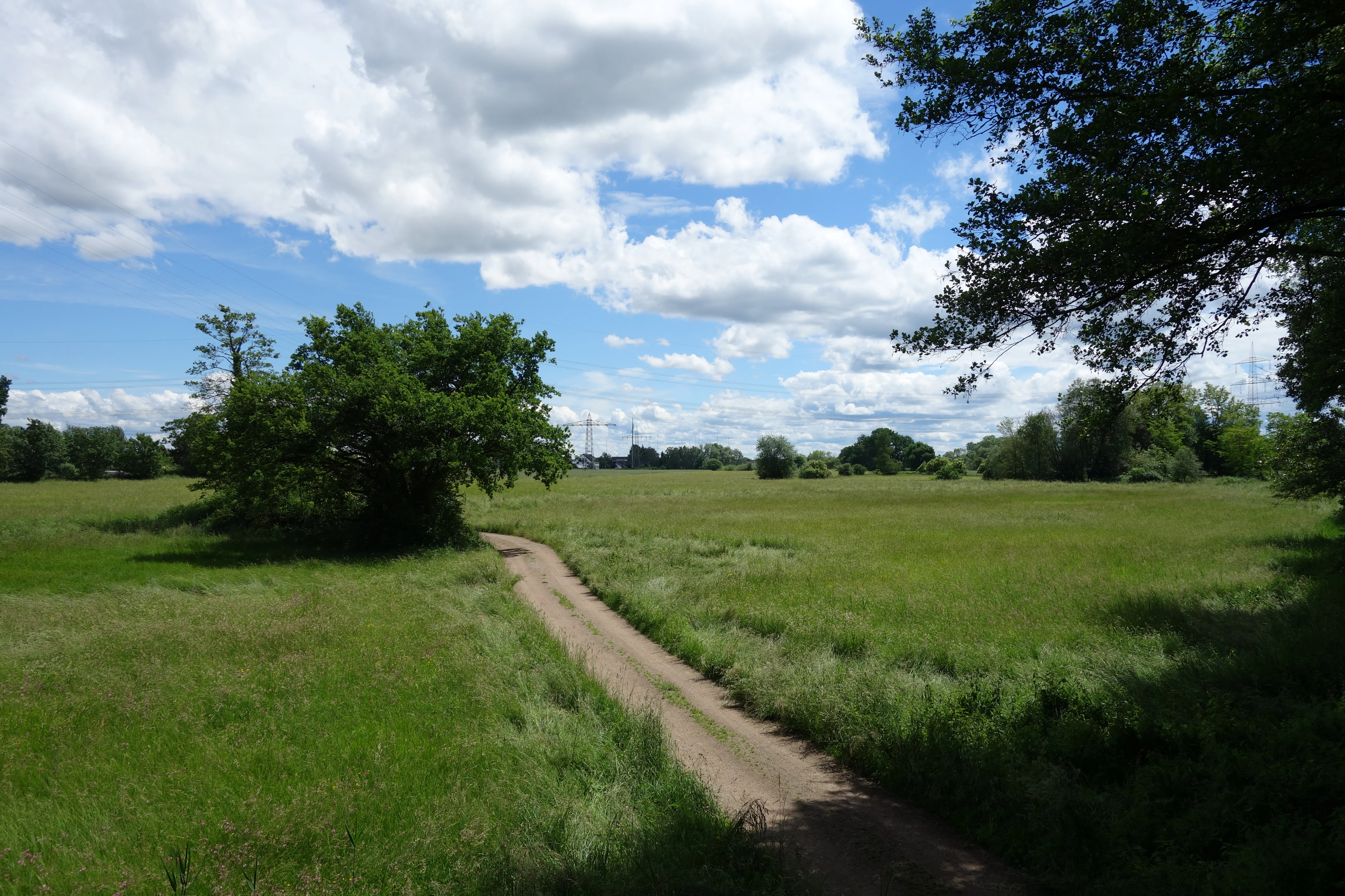
A dirt path leads through an open, grassy field under a bright blue sky with scattered clouds in the Pechgraben nature reserve.
A rural dirt path winding through the green meadows and open areas of the Pechgraben bei Klein-Krotzenburg nature reserve.

Pechgraben bei Klein-Krotzenburg history and protected-area timeline

Pechgraben bei Klein-Krotzenburg was officially designated as a nature reserve (Naturschutzgebiet) in 1998, giving formal protection to a stretch of forest and wetland that had long survived as a relatively undisturbed remnant of the older Main floodplain. The designation was part of broader efforts in Hesse to secure remaining fragments of the Holocene Main floodplain before further loss of habitat occurred.

The conservation impetus for the site was closely tied to its unusual landscape history: the Pechgraben corridor represents a fossil flood channel of the Main, a hydrological inheritance from the post-glacial period that continued to support wetland and forest communities well after the original river course moved elsewhere. Recognizing this unusual combination of geological legacy and ecological richness, the conservation authorities moved to formally protect the area, assigning it the official identifier 1438022 and administering it under the jurisdiction of the lower nature conservation authority of the Landkreis Offenbach.

Pechgraben bei Klein-Krotzenburg landscape and geographic character

The landscape of Pechgraben bei Klein-Krotzenburg is defined by a narrow, sinuous valley corridor that follows an old Main flood channel. Although the broader surrounding area has long been transformed by agriculture and the expansion of Seligenstadt and Klein-Krotzenburg, the reserve retains a clearly differentiated valley profile shaped by the stream and by the hydrological conditions inherited from the ancient floodway.

Within this corridor, the most striking landscape elements are the alternating belts of near-natural deciduous woodland, low-lying wet meadows, reedbeds, and tall-sedge marsh communities. The waterways, damp hollows, and slightly elevated dry ridges within the forest create frequent transitions between dry and wet conditions over short distances. This fine-grained landform variation is one of the defining visual characteristics of the reserve and gives it a distinctly mosaic-like appearance compared to the more uniform land cover of the surrounding lowlands.

Pechgraben bei Klein-Krotzenburg ecosystems, habitats, and plant life

Ecologically, Pechgraben bei Klein-Krotzenburg belongs to the Holocene floodplain systems of the Main, and its habitat composition reflects this origin. The dominant woodland component is made up of near-natural deciduous forest communities typical of floodplain conditions, with a mixture of tree species adapted to periodic moisture variation. These woodlands are interspersed with open wetland habitats: wet meadows, reedbeds (Röhrichte), and large sedge marsh (Großseggenrieder) communities that occupy the wetter parts of the corridor.

Together, these habitat types form a compact ecological unit that retains much of the structural diversity characteristic of intact floodplain landscapes. The transition zones between forest and open wetland are particularly valuable for overall biodiversity, supporting plant communities that depend on the unstable boundary between terrestrial and aquatic conditions. As a result, the reserve acts as a small but ecologically dense pocket of habitat diversity within an otherwise heavily used regional landscape.

Pechgraben bei Klein-Krotzenburg wildlife and species highlights

The reserve supports a rich community of animals associated with floodplain forest, reedbeds, wet meadows, and large sedge marsh communities. These structurally diverse habitats provide breeding, feeding, and refuge conditions for many species that have become scarce elsewhere in the intensively used Lower Main valley.

Particularly important are the species groups tied to reedbeds and sedge marsh, where birds and insects associated with wetland vegetation find conditions resembling more extensive floodplain landscapes that have largely disappeared from the region. The combination of closed canopy forest and open wetland also supports a varied mix of woodland and wetland-dependent fauna, contributing to the reserve's significance as a local biodiversity refuge within the Landkreis Offenbach.

Pechgraben bei Klein-Krotzenburg conservation status and protection priorities

The conservation value of Pechgraben bei Klein-Krotzenburg rests on the preservation of an unusually intact fragment of the Holocene Main floodplain in a region where this landscape type has been extensively lost. By combining near-natural deciduous forest, wet meadows, reedbeds, and large sedge marsh within a single protected site, the reserve maintains habitat types that are individually rare and collectively even rarer in their original floodplain configuration.

Officially classified under IUCN Category IV as a Habitat/Species Management Area, the site is intended to both protect existing communities of threatened species and to support their long-term development. Its role within the broader network of nature reserves in the Landkreis Offenbach is therefore not just local but also regional, helping to maintain ecological connectivity and safeguard floodplain species in the Lower Main valley.

Pechgraben bei Klein-Krotzenburg cultural meaning and human context

The name Pechgraben itself reflects long-standing local familiarity with the stream corridor and the surrounding woodland, and the area is closely tied to the identity of Klein-Krotzenburg as a distinct settlement within Seligenstadt. As a surviving fragment of an older Main flood channel, the reserve also carries a subtle landscape-historical meaning: it preserves a feature that would otherwise only be inferred from older maps and geomorphological analysis, anchoring a piece of regional natural history within the contemporary cultural landscape of the Lower Main valley.

Top sights and standout views in Pechgraben bei Klein-Krotzenburg

A surviving remnant of a post-glacial Main flood channel in Hesse.

A tight mosaic of near-natural deciduous forest, wet meadows, reedbeds, and large sedge marsh within a single roughly 34 hectare site.

A locally important refuge for floodplain-dependent plant and animal species in the intensively used Lower Main valley.

Part of the formally designated nature reserve network of the Landkreis Offenbach since 1998, classified as an IUCN Category IV Habitat/Species Management Area.

Best time to visit Pechgraben bei Klein-Krotzenburg

Pechgraben bei Klein-Krotzenburg can be appreciated across much of the year, but spring and early summer typically offer the most active bird and insect life as wetland and woodland species establish breeding territories. Late spring also brings the most expressive growth of reedbeds, sedge marsh, and floodplain meadow vegetation, making the habitat mosaic visually distinctive.

Autumn offers a contrasting appeal, when the near-natural deciduous forest components take on seasonal color and the wetter parts of the corridor contrast with the surrounding cultivated lowlands. Because the reserve depends on intact hydrological conditions, periods of stable weather that preserve groundwater levels tend to showcase the wetland communities most clearly.

Monthly climate preview

Long-term representative point measurements tracking monthly temperature and precipitation rhythm in Hessen

Pechgraben bei Klein-Krotzenburg Climate Normals and Annual Temperature Patterns

Historical climatology data reveals measured monthly averages for temperature and precipitation across the representative coordinate in Hessen. Exploring the complete twelve-month record provides a detailed analytical profile of long-term climatic variations.
Annual mean10 °C
0 °C21 °C
Jan
Feb
Mar
Apr10°
May14°
Jun18°
Jul21°
Aug20°
Sep15°
Oct10°
Nov
Dec
Warmest month
July

20.6 °C

Coolest month
January

0.2 °C

Wettest month
July

2.2 mm/day

Driest month
April

1.4 mm/day

Park location guide

Geography guide, regional context, and park location map for Pechgraben bei Klein-Krotzenburg

Pechgraben bei Klein-Krotzenburg park geography, regions, and map view in Germany

Understand where Pechgraben bei Klein-Krotzenburg sits in Germany through a broader geographic reading of the surrounding landscape, nearby location context, and its mapped position within the national park landscape.

How Pechgraben bei Klein-Krotzenburg fits into Germany

Germany is a federal republic in Western and Central Europe with a population of over 83 million across sixteen constituent states. It is Europe's largest economy by nominal GDP and a major global exporter and importer. The capital is Berlin, and the country borders Denmark, Poland, Czech Republic, Austria, Switzerland, France, Luxembourg, Belgium, and the Netherlands.

Wider geography shaping Pechgraben bei Klein-Krotzenburg in Germany

Germany is located in Western and Central Europe, spanning 357,022 km². It borders Denmark to the north, Poland and the Czech Republic to the east, Austria and Switzerland to the south, and France, Luxembourg, Belgium, and the Netherlands to the west. The country has coastlines on the Baltic Sea and North Sea to the north, with the Alps located in the southern region.

Map view of Pechgraben bei Klein-Krotzenburg

Use this park location map to pinpoint Pechgraben bei Klein-Krotzenburg in Germany, understand its exact geographic position, and read its mapped placement within the surrounding landscape more clearly.

Pigeon | © OpenStreetMap contributors

Location context for Pechgraben bei Klein-Krotzenburg

Hessen

Visual exploration of floodplain forests, wetlands, and protected valley terrain

Pechgraben bei Klein-Krotzenburg Photos and Landscape Scenery

Visual records capture the intricate mosaic of deciduous woodland, wet meadows, and marsh communities defining the protected valley floor. Detailed photography reveals the unique topography and ecological character of an ancient river flood channel.

A dirt path leads through an open, grassy field under a bright blue sky with scattered clouds in the Pechgraben nature reserve.

Park atlas

Compare adjacent floodplain reserves and regional habitat networks across the Lower Main valley

Explore Parks Near Pechgraben bei Klein-Krotzenburg and Surrounding Regional Protected Areas

Browse protected natural areas and valley reserves situated close to Pechgraben bei Klein-Krotzenburg to examine wider regional ecology. Comparing these surrounding habitats reveals distinct watershed patterns and floodplain remnants across the broader Hesse landscape.
Nature reserveLandkreis Offenbach
About 1.7 km away#1 closest

Southwest

Kortenbach bei Froschhausen Nature Reserve: Geographic Mapping and Protected Forest Overview

Hardwood floodplain woodland in Landkreis Offenbach

Kortenbach bei Froschhausen protects a compact, groundwater-influenced forest ecosystem within the Offenbach district. This nature reserve acts as a critical refuge for mature broadleaf trees, including the rare European white elm. Our atlas entry focuses on the site's stream-fed terrain and its role as a preserved forest fragment amidst surrounding agricultural and transport infrastructure.

Area
0.405 km²
Established
1998
IUCN
IV
A soft watercolor illustration of a wetland scene with a calm pool of water, grassy banks, a line of trees, and distant rolling hills against a white background.
Nature reserveHesse
About 3.8 km away#2 closest

Southeast

Affelderchen und Rettichbruch von Klein-Welzheim: Protected Wetland Nature Reserve in Hesse

Examining the ecological landscape and hydrology of this German protected area

Affelderchen und Rettichbruch von Klein-Welzheim is a notable nature reserve in Hesse characterized by its wet meadows and marshy woodland. This geographic study covers the protected site's transition from an agricultural lowland depression to a dynamic, beaver-influenced wetland system that supports endangered plant species and diverse breeding avian populations.

Area
0.512 km²
Established
1983
Relief
Lowland
Scope
Terrestrial
Nature reserveLandkreis Offenbach
About 4.3 km away#3 closest

South

Langhorst von Hainburg und Seligenstadt: Geography of a Main Valley Nature Reserve

Protected floodplain forest and wet meadows in Landkreis Offenbach

Langhorst von Hainburg und Seligenstadt is a key nature reserve in Landkreis Offenbach, Germany. This protected area showcases a preserved floodplain mosaic, featuring structurally diverse broadleaf forest, open wet meadows, and historical stream relics of the Main river system, serving as an essential ecological refuge within a densely populated region.

Area
0.823 km²
Established
1996
IUCN
IV
Relief
Lowland
A wide watercolor illustration depicting a green wetland landscape with reed beds, grasses, and distant hills under a pale sky.
Nature reserveHessen
About 5.8 km away#4 closest

West

Gräbenwäldchesfeld von Hausen: Nature Reserve and Protected Wetland Landscape Geography

Mapping rare meadow ecosystems in the Hessen region

Gräbenwäldchesfeld von Hausen functions as a critical protected nature reserve, safeguarding species-rich wet meadows and moisture-dependent flora in the town of Obertshausen. This atlas entry details the site's role within the Landkreis Offenbach, focusing on the preservation of reed beds and marsh landscapes amidst a predominantly urbanized terrain.

Area
0.054 km²
Established
1990
IUCN
IV
Relief
Lowland
A horizontal watercolor painting showing a stylized, layered forest scene in muted green, pink, and yellow tones on a white background.
Nature reserveHesse
About 6 km away#5 closest

Northwest

Lauternsee bei Klein-Auheim Nature Reserve: Geography and Protected Bog Landscape

A historic high terrace habitat within the Hesse woodland region.

Lauternsee bei Klein-Auheim represents a specialized Flachmoor habitat that emerged from a former river channel of the Main. This nature reserve serves as an important ecological anchor in the lower Main valley, protecting essential wetlands, amphibian populations, and unique marsh plant communities within an expansive forest setting.

Established
1987
Nature reserveLandkreis Offenbach
About 6.1 km away#6 closest

South

Rotsohl und Thomassee von Dudenhofen Nature Reserve in Landkreis Offenbach, Germany

Protected pine forest, wetland habitat, and pond mosaic

Spanning 52 hectares in the Rhine-Main lowlands, this nature reserve is defined by its compact interplay of dry pine forest and diverse wet open habitats. Known for the Postteiche and Weißensee ponds, it serves as a significant site for both breeding and migratory bird populations in a densely settled metropolitan region.

Area
0.519 km²
Established
1999
IUCN
IV
A soft watercolor painting of a wetland area with grasses, water, and a tree line in the background.
Nature reserveHessen
About 6.5 km away#7 closest

Southeast

Bong’sche Kiesgrube und Mainufer bei Mainflingen: Protected Wetland and River Geography

Explore the lake and riparian terrain within the Hessen river system.

Formed from former gravel extraction sites and floodplain stretches, Bong’sche Kiesgrube und Mainufer bei Mainflingen provides a vital ecological link along the Main river. The reserve preserves a distinct mosaic of open water, reeds, and willow-dominated woodland, serving as a critical habitat for diverse waterbirds in central Germany.

Area
94.52 km²
Established
1977
IUCN
IV
Watercolor illustration of a soft rolling landscape with grassy fields, scattered trees, and rolling hills in shades of green and yellow.
Nature reserveHessen
About 6.9 km away#8 closest

Northwest

Amerikafeld und Schindkaute bei Steinheim: Nature Reserve and Protected Grassland Map

Rare sand dry grassland habitat within the Hessen metropolitan region.

Amerikafeld und Schindkaute bei Steinheim is a protected nature reserve in Hanau that shelters scarce sand dry grasslands. The terrain, defined by ice-age sandy deposits, remains an important ecological island, maintaining an open steppe-like character through historic grazing practices in a landscape otherwise dominated by urban growth.

Area
16 km²
Established
1995

Common questions about visiting, size, designation, and location context for Pechgraben bei Klein-Krotzenburg

Pechgraben bei Klein-Krotzenburg FAQs for park facts, access, geography, and protected area context

Find quick answers about Pechgraben bei Klein-Krotzenburg, including protected-area facts, park geography, trail and visitor context, and how the park fits into its surrounding country and regional landscape.
MoriAtlas Explorer

Continue Your Protected Areas Search Across the Global Atlas

Deepen your exploration by continuing the structured search for national parks and protected areas worldwide. Utilize the comprehensive filtering capabilities to compare different conservation landscapes and refine your understanding of global park geography. Discover more about the distribution and characteristics of protected natural areas.

Global natural geography