Mori Atlas logo
Protected areaPemanggil Island

Examining the offshore island topography, Batu Buau landmarks, and South China Sea maritime context.

Pemanggil Island Protected Area: Mapping the Geographic Features and Coastal Landscapes of Johor

Pemanggil Island stands as a distinct protected landscape situated within the South China Sea, approximately 45 kilometers off the coast of Johor. This geography-focused profile traces the island's central hill topography, the unique boulder formation known as Batu Buau, and the isolated bay environments that characterize its shoreline. Users can observe how the island interacts with the broader Mersing District island cluster, providing a clear map of its natural terrain and undisturbed offshore setting.

offshore islanddeep-sea fishingSouth China SeaMersing DistrictJohor islandssmall island community

Pemanggil Island

Protected area

Park overview

Structured park overview, official facts, and landscape profile for Pemanggil Island

Pemanggil Island park facts, protected area profile, and essential visitor context

Review the core facts for Pemanggil Island, including designation, size, terrain, visitor scale, habitats, and operating context in one park-focused overview.

About Pemanggil Island

Pemanggil Island is a relatively small, lightly populated island in Malaysian territory that combines a working maritime economy with notable coastal geography and cultural landmarks. Located in Mersing District, Johor, it is one of several islands scattered along the eastern Johor coastline, and it shares the broader South China Sea seascape with better-known neighbors such as Tioman, Aur, Rawa, Besar, Sibu, and Tinggi. The island's compact size, modest elevation, and minimal infrastructure give it a distinct remote character compared with Malaysia's more heavily developed marine destinations.

The local economy is closely tied to the sea. Deep-sea fishing is a defining activity, with the surrounding waters regarded as good hunting grounds for marlins and mackerel. This fishing heritage is embedded in the island's identity and is part of why Pemanggil draws recreational anglers and small-scale commercial fishers alike. Onshore, the island is supported by a sparse but functioning community anchored in the village of Kampung Buau, with a single primary school, Sekolah Kebangsaan Pulau Pemanggil, serving the small resident population.

Geographically, Pemanggil features a hill at the outcrop of the island, offering a recognizable landform against the surrounding sea. On the northeastern coast lies Teluk Lancang, described as an isolated bay; near the center of the island sits a large boulder called Batu Buau, which locals regard as sacred. These features, along with the island's offshore position within a cluster of Johor islands, give Pemanggil a layered profile: part fishing hub, part community island, and part culturally meaningful coastal landscape.

Quick facts and research context for Pemanggil Island

Pemanggil Island lies in the South China Sea within the Mersing District of Johor, Malaysia, roughly 45 kilometers east of the Mersing mainland. It covers a land area of about 8.82 square kilometers and reaches a highest elevation of around 223 meters. The island has a very small permanent population, recorded at 34 residents in 2020, predominantly Malaysian Malays who speak Malay and the local Johor-Riau dialect.

Administratively, Pemanggil is part of the Mersing District under the state of Johor, with its own designated mukim. The island operates on Malaysia Standard Time, and postal services use the postcode 86800. Its nearest maritime neighbors include Pulau Tioman, Pulau Rawa, Pulau Aur, Pulau Besar, Pulau Sibu, and Pulau Tinggi, situating Pemanggil within a recognized Johor island group rather than as a standalone offshore point.

Protection and recognition

Analysis of mixed protection frameworks and administrative designations

Pemanggil Island Protection Status and Documented Conservation Scope

Examine the documented protection status and management scope established for Pemanggil Island within regional conservation frameworks. Structured records compile available designation history and international recognition sources for detailed geographic review.

Protection details

Protection scope
Mixed
Transboundary protection
No
Park context

Deeper park guide and search-rich context for Pemanggil Island

Pemanggil Island history, landscape, wildlife, and travel context

Explore Pemanggil Island through its history, landscape character, ecosystems, wildlife, conservation priorities, cultural context, and seasonal travel timing in a structured park guide built for atlas discovery and search intent.

Why Pemanggil Island stands out

Pemanggil Island is best known as a deep-sea fishing destination, particularly for anglers seeking marlin and mackerel in surrounding South China Sea waters. It is also known for the large central boulder known locally as Batu Buau, considered sacred by island residents, and for the isolated Teluk Lancang bay along its northeastern coast. More broadly, the island's identity is shaped by the combination of productive offshore fishing grounds and quiet island terrain. The hill outcrop adds a visible landform signature, while the low population keeps the surrounding environment relatively undisturbed, reinforcing Pemanggil's reputation among visitors as a remote, sea-oriented Johor island rather than a developed resort destination.
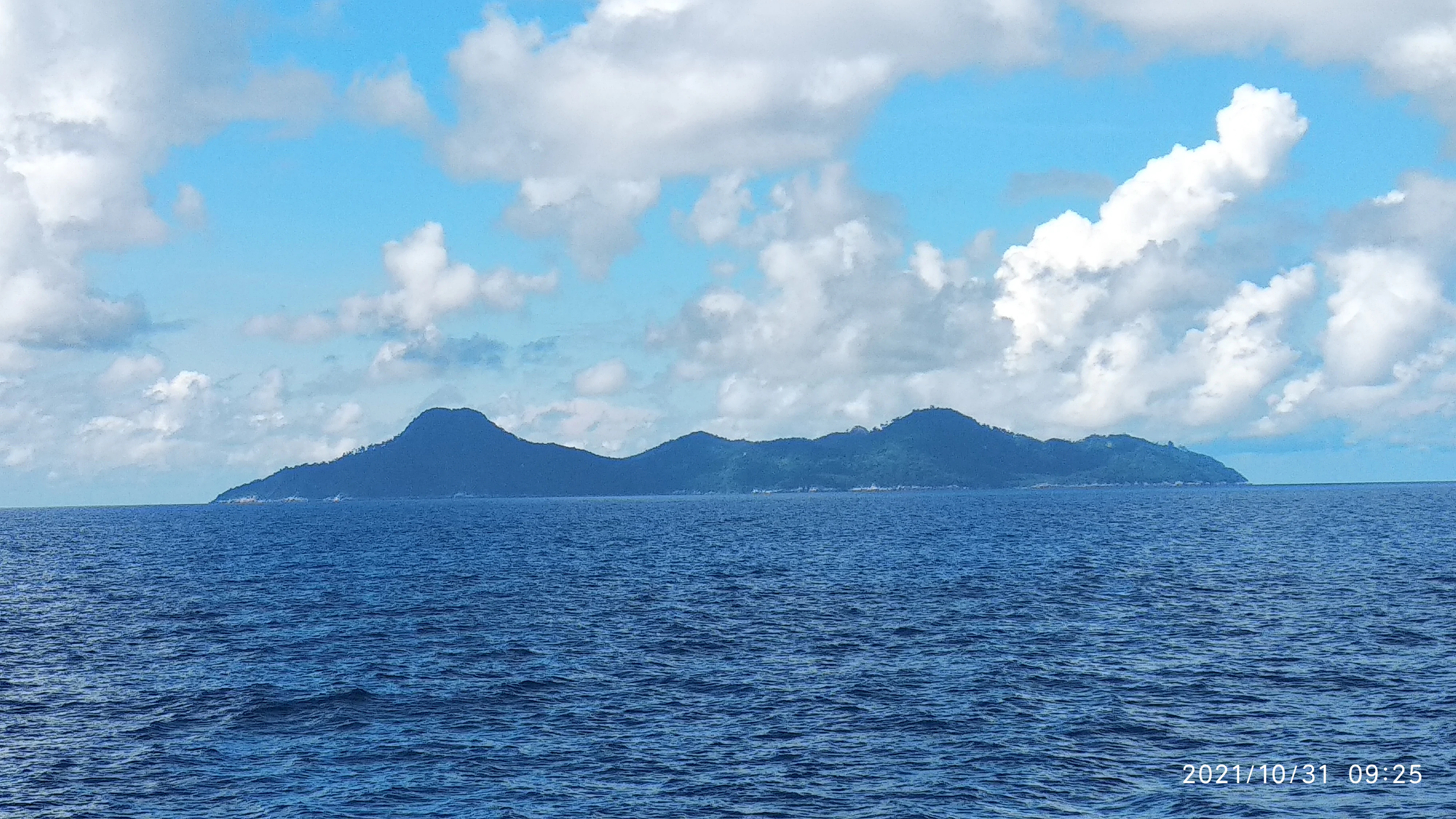
A distant view of a hilly, forested island silhouette surrounded by the open ocean under a bright, cloudy blue sky.
A view of Pemanggil Island seen from the sea.

Pemanggil Island history and protected-area timeline

Pemanggil Island's documented modern history is closely tied to its role as a small Malaysian fishing settlement within Mersing District, Johor. The population has historically been small, and as of 2020 it was recorded at only about 34 residents, most of them Malaysian Malays who speak Malay alongside the regional Johor-Riau dialect. The island's cultural identity has been shaped in part by longstanding local landmarks such as the Batu Buau boulder, which residents regard as sacred and which has long been part of the island's oral and community memory.

The island also serves as an established venue for deep-sea fishing, a use that has become one of its most recognized identities in recent decades. Although the settlement itself is tiny, the surrounding waters have supported marlin and mackerel fisheries that connect Pemanggil to broader regional fishing activity originating from Mersing Town on the mainland. This fishing economy remains a defining part of the island's living history, linking present-day residents to maritime traditions along this stretch of the South China Sea coast.

Pemanggil Island landscape and geographic character

Pemanggil Island's landscape is shaped by its position as an offshore landmass rising modestly from the South China Sea. The island covers approximately 8.82 square kilometers and reaches a highest elevation of about 223 meters, with a central hill forming the main topographical feature. This elevated outcrop gives the island a visible silhouette against the surrounding seascape and contributes to its distinct offshore geography among Johor's islands.

Along the coast, the northeastern shoreline features Teluk Lancang, an isolated bay that adds variety to the island's coastal profile. Closer to the center of the island lies the large boulder known locally as Batu Buau, a distinctive landform that contributes both visually and culturally to Pemanggil's setting. The combination of the central hill, rocky interior landmarks, and varied bays defines Pemanggil as a small but geographically memorable island.

Pemanggil Island ecosystems, habitats, and plant life

The natural environment of Pemanggil Island is defined primarily by marine and coastal conditions. The surrounding South China Sea waters are recognized for supporting pelagic species such as marlin and mackerel, making the offshore zone ecologically significant for larger migratory fish. These productive waters place Pemanggil within a broader Johor island ecosystem that includes Tioman, Aur, Rawa, Besar, Sibu, and Tinggi, all of which share similar marine conditions.

Onshore vegetation and habitat reflect the island's modest size, low population, and limited development. Sparse settlement and minimal land conversion mean that much of the island's terrestrial cover remains relatively undisturbed, although detailed ecological data is limited. The combination of undisturbed interior terrain, coastal bays like Teluk Lancang, and offshore fisheries gives Pemanggil a recognizable but lightly documented natural character.

Pemanggil Island wildlife and species highlights

Wildlife attention around Pemanggil Island centers on marine fauna rather than terrestrial species. The waters around the island are recognized as productive hunting grounds for marlin and mackerel, both pelagic species of considerable interest to recreational and small-scale commercial fishers. These fisheries are the most clearly documented wildlife-related feature of Pemanggil.

Information about the island's broader terrestrial fauna, birdlife, or other native species is limited in available sources. While the island's low population and limited development suggest conditions favorable for undisturbed coastal ecology, specific wildlife inventories are not provided, and visitors typically encounter Pemanggil's wildlife through its offshore fishing character rather than through on-island species observation.

Pemanggil Island conservation status and protection priorities

Pemanggil Island's conservation profile is largely implicit rather than strongly documented. Its very low population density, minimal development footprint, and position within a group of relatively undisturbed Johor islands mean that much of its terrestrial and marine environment remains in a naturally buffered state. The island's inclusion in a recognized cluster of Mersing District islands, alongside Pulau Tioman, Pulau Rawa, Pulau Aur, Pulau Besar, Pulau Sibu, and Pulau Tinggi, situates it within a regional maritime zone that has value for sustaining coastal ecosystems and pelagic fisheries.

The island's waters are noted as a productive habitat for marlin and mackerel, which gives Pemanggil indirect conservation relevance for sustaining migratory and pelagic marine species. Meanwhile, culturally significant natural features such as the central Batu Buau boulder are protected through local reverence rather than formal protected-area status. There is no clearly documented formal national park, marine park, or strict conservation designation associated with the island in the available sources.

Pemanggil Island cultural meaning and human context

Cultural life on Pemanggil Island is anchored in a small, predominantly Malay community that maintains traditional ties to the sea. The island's residents speak Malaysian Malay together with the regional Johor-Riau Malay dialect, and community identifiers such as the ketua kampung (village head) of Kampung Buau, named in local sources as Encik Rafa Bin Abu Niat, reflect an organized local governance structure. Educational services are provided through a single primary school, Sekolah Kebangsaan Pulau Pemanggil, which has a very small student body and serves as a focal point of the island's daily community life.

A defining cultural feature is the locally sacred Batu Buau boulder at the center of the island, which residents regard as a place of spiritual significance. This reverence for a natural landmark gives Pemanggil a cultural identity in which the physical landscape and community belief systems are closely intertwined, a feature that distinguishes the island from purely recreational or fishing-oriented offshore destinations.

Top sights and standout views in Pemanggil Island

Pemanggil Island's standout features include its offshore setting within a cluster of Johor islands, its productive deep-sea fishing reputation for marlin and mackerel, and its culturally meaningful natural landmarks. The central Batu Buau boulder is particularly distinctive, serving as both a defining landform and a sacred site for the local community. The northeastern Teluk Lancang bay adds another recognizable coastal feature.

In addition to its physical landmarks, the island's highlights include its small resident community, centered in Kampung Buau, and its quiet, lightly developed atmosphere. For visitors, Pemanggil offers a combination of open-water fishing opportunity, scenic offshore views, and exposure to a traditional Johor island way of life, all within easy boating distance of Mersing Town on the mainland.

Best time to visit Pemanggil Island

Pemanggil Island's appeal is shaped largely by marine conditions, so visit timing depends primarily on sea state and fishing rather than dramatic seasonal ecological shifts. The island lies within Malaysia's tropical maritime climate, where warm conditions and generally navigable waters support year-round boat access from Mersing Town. Anglers targeting marlin and mackerel typically find conditions favorable when offshore waters are calmer, allowing safer access to the deeper fishing grounds east of the island.

Because the island's small resident population is tied to traditional fishing rhythms, visitors interested in cultural landmarks such as Batu Buau and coastal scenery at Teluk Lancang will find the atmosphere consistent throughout the year. Travelers planning a Pemanggil visit primarily benefit from considering periods of calmer sea conditions rather than dramatic seasonal ecological change, as the island's tropical setting offers relatively stable conditions across most of the year.
Monthly climate preview

Long-term representative monthly temperature and precipitation rhythm

Pemanggil Island Climate Normals, Average Temperature and Precipitation

Pemanggil Island exhibits a consistent annual temperature baseline alongside varying monthly precipitation averages recorded across twelve distinct periods. Reviewing the complete meteorological profile reveals deeper monthly patterns across the protected landscape.
Annual mean28 °C
27 °C29 °C
Jan27°
Feb27°
Mar27°
Apr28°
May29°
Jun29°
Jul28°
Aug28°
Sep28°
Oct28°
Nov28°
Dec27°
Warmest month
May

28.7 °C

Coolest month
January

26.6 °C

Wettest month
December

13.2 mm/day

Driest month
February

3.8 mm/day

Park location guide

Geography guide, regional context, and park location map for Pemanggil Island

Pemanggil Island park geography, regions, and map view in Malaysia

Understand where Pemanggil Island sits in Malaysia through a broader geographic reading of the surrounding landscape, nearby location context, and its mapped position within the national park landscape.

How Pemanggil Island fits into Malaysia

Malaysia is a federal constitutional monarchy located in Southeast Asia. The country consists of 13 states and three federal territories, divided by the South China Sea into Peninsular Malaysia on the Indochinese Peninsula and East Malaysia on the island of Borneo. With a population of over 34 million, it achieved independence from Britain in 1957 and became a modern federation in 1963. The country is recognized for its multicultural population, tropical climate, and significant economic role in the region.

Wider geography shaping Pemanggil Island in Malaysia

Malaysia occupies a strategic position in Southeast Asia, split by the South China Sea into two distinct regions. Peninsular Malaysia lies on the Indochinese Peninsula, sharing a land border with Thailand to the north and maritime borders with Singapore, Vietnam, and Indonesia. East Malaysia occupies the northern portion of Borneo, sharing land borders with Brunei and Indonesia, and maritime borders with the Philippines and Vietnam. The country's terrain includes coastal plains, mountain ranges such as the Titiwangsa in the peninsula, and extensive tropical rainforests.

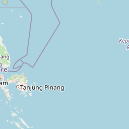
Map view of Pemanggil Island

Use this park location map to pinpoint Pemanggil Island in Malaysia, understand its exact geographic position, and read its mapped placement within the surrounding landscape more clearly.

Pigeon | © OpenStreetMap contributors

Location context for Pemanggil Island

Johor

Explore visual records of offshore topography, rocky bays, and remote island environments.

Pemanggil Island Photos, Landscapes, and Coastal Scenery Visual Guide

Visual documentation captures the rugged central hills, isolated coastal bays, and marine surroundings that define Pemanggil Island. Examining these field photographs reveals the distinctive physical landforms and protected coastal character of this remote Johor island.

A distant view of a hilly, forested island silhouette surrounded by the open ocean under a bright, cloudy blue sky.

Park atlas

Compare adjacent South China Sea island geography and regional marine reserves

Parks Near Pemanggil Island and Surrounding Protected Marine Landscapes

Browse nearby national parks and protected areas sharing the maritime characteristics of Pemanggil Island. Expanding the geographic scope helps compare regional island terrain, offshore habitats, and coastal protected zones across the Johor cluster.
Watercolor illustration of a horizontal landscape featuring a winding river, green forests, and soft, pastel colored mountain ridges against a white background.
Marine protected areaJohor
About 26 km away#1 closest

Southeast

Aur Island Marine Protected Area: Johor Regional Coastal and Island Geography

Rugged island terrain and sheltered coral ecosystems.

Aur Island serves as a significant marine protected area within the Johor Marine Park archipelago. Located in the South China Sea, the island is characterized by its hilly interior, white-sand shorelines, and diverse offshore coral reef systems. Its geographic proximity to neighbouring Dayang Island creates a paired landscape that highlights the environmental importance of these remote Malaysian waters.

Area
14.5 km²
Relief
Lowland
Climate
Tropical
Access
Moderate access
A minimalist watercolor illustration depicting abstract green rolling hills and distant pink-toned ridges against a white background.
Wildlife reservePahang
About 31 km away#2 closest

Northwest

Pulau Tioman Wildlife Reserve: Mapping Island Rainforests and Marine Boundaries

Protected island geography within the Pahang region

Covering the forested interior of Tioman Island, this wildlife reserve protects lowland and hill rainforest habitats that rise to Gunung Kajang. The area serves as a significant conservation landscape, bridging remote inland mountain terrain with vibrant coral-fringed coastlines in the South China Sea.

Area
136 km²
Established
1972
Relief
Mountain
Climate
Tropical
Protected areaJohor
About 39 km away#3 closest

Southwest

Tinggi Island Protected Area: Geography, Rainforest Terrain, and Johor Coastal Map

Mountainous forest meets extensive coral-rich coastal waters.

Located southeast of Mersing, Tinggi Island is defined by its dramatic silhouette and dense rainforest interior. The protected landscape stretches from the elevated peak of Mount Semundu down to a shoreline of white sand and coastal caves, creating a distinct marine and terrestrial environment unique to the Johor region.

Water
Major water bodies
Season
Year-round
A watercolor painting showing layers of soft green and pink rolling hills, with a line of trees in the midground and an open, flat foreground.
Protected areaJohor
About 40 km away#4 closest

West

Rawa Island Protected Area: Coastal Geography and Island Landscape Context in Johor

A protected coral island within the Johor archipelago

Rawa Island serves as a significant protected landscape off the coast of Johor, Malaysia. Defined by its sharp contrast between rocky cliffs and clear, coral-filled waters, the island represents a crucial node in regional island geography. Delve into the spatial characteristics and environmental features of this South China Sea destination through our map-driven atlas framework.

Area
0.23 km²
Water
Water-dominated
A minimalist watercolor illustration depicting a tropical island coastline with sand beaches, green trees, and rolling hills in the background.
Marine protected areaJohor
About 41 km away#5 closest

West

Besar Island Marine Protected Area: Coastal Geography and Protected Waters in Johor

Mapping the island's reef ecosystems and tropical landscape

Besar Island offers a distinct look at a small-scale marine protected area off the Johor coast. Its geography encompasses a transition from sandy beach fronts to a hilly, jungle-clad interior, all contained within a gazetted two-nautical-mile conservation zone. The surrounding waters support approximately 60 marine species, making this an essential case study for understanding protected marine habitats within the Babi Islands archipelago.

Area
4.77 km²
Relief
Upland
Climate
Tropical
Access
Easy access
Marine protected areaJohor
About 50 km away#6 closest

Southwest

Sibu Island: Marine Protected Area and Coastal Landscape Analysis

Mapping the coral reefs and pyroclastic terrain of the Johor coast

Sibu Island is a protected marine area in the South China Sea, distinguished by its unique pyroclastic geology and surrounding coral reef ecosystems. This entry provides a structured look at the island's coastal geography, vegetation, and maritime boundaries off the coast of Mersing, Johor. Access detailed geographic context for this tropical landscape.

Area
4.05 km²
Established
1993
Relief
Lowland
Climate
Tropical
National parkJohor
About 100 km away#7 closest

West

Endau-Rompin National Park: Ancient Tropical Rainforest Protected Landscape in Johor, Malaysia

Explore unique mapped geography and ancient geological features.

Endau-Rompin National Park in Johor, Malaysia, is a testament to Earth's ancient history, housing tropical rainforests built upon geological formations around 248 million years old. This protected area offers a detailed look at rugged mountainous terrain, vital river systems, and a diverse mapped landscape, crucial for understanding regional geography and conservation. Its status as one of the oldest rainforest complexes makes it a significant site for exploring the planet's prehistoric natural heritage and protected land distribution.

Area
870 km²
Established
1993
IUCN
II
Relief
Mountain
Nature reserveJohor
About 163 km away#8 closest

Southwest

Pulai River Nature Reserve: Johor Coastal Mangrove and Estuarine Geography

Protected Ramsar wetland and coastal landscape in southern Malaysia.

Spanning from the highlands of Mount Pulai to the Tebrau Straits, Pulai River Nature Reserve acts as a major ecological interface in Johor. This site encompasses dense mangrove forest reserves and the country's single largest seagrass bed, serving as a primary study area for regional coastal conservation and wetland management.

Established
2003
Relief
Lowland
Scope
Mixed
Water
Water-dominated

Common questions about visiting, size, designation, and location context for Pemanggil Island

Pemanggil Island FAQs for park facts, access, geography, and protected area context

Find quick answers about Pemanggil Island, including protected-area facts, park geography, trail and visitor context, and how the park fits into its surrounding country and regional landscape.
MoriAtlas Explorer

Continue Your Protected Areas Search Across the Global Atlas

Deepen your exploration by continuing the structured search for national parks and protected areas worldwide. Utilize the comprehensive filtering capabilities to compare different conservation landscapes and refine your understanding of global park geography. Discover more about the distribution and characteristics of protected natural areas.

Global natural geography