
Mori Atlas logo
Nature reservePfungstädter Moor

Mapping the ancient river meanders, alder carr forests, and managed wetland landscape.

Pfungstädter Moor Nature Reserve: A Detailed Atlas of Hessian Wetland Geography and Terrain

(Naturschutzgebiet Pfungstädter Moor)

Pfungstädter Moor represents a significant protected nature reserve within the Hessian Rhine plain, encompassing roughly 97 hectares of rare wetland complex. This site traces the course of an ancient, silted Neckar river loop, preserving a distinct ecological enclave of bog remnants and dense alder carr forest. Through active water management and restoration, the area continues to serve as a critical refuge for specialized reed-nesting bird populations and diverse bog flora within a largely agricultural regional landscape.

nature reservewetlandmoorbogalder carr forestreed bed
A stylized digital illustration of a wetland scene with a calm, winding stream, lush green reeds, trees, and soft hills in the background under a pale, muted sky.

Pfungstädter Moor

Nature reserve

Park overview

Structured park overview, official facts, and landscape profile for Pfungstädter Moor

Pfungstädter Moor park facts, protected area profile, and essential visitor context

Review the core facts for Pfungstädter Moor, including designation, size, terrain, visitor scale, habitats, and operating context in one park-focused overview.

About Pfungstädter Moor

Pfungstädter Moor occupies a small but ecologically significant footprint in the Hessian Rhine plain, between Pfungstadt to the north and Bickenbach to the south. Although it covers only about 97 hectares, the reserve compresses several rare habitat types into one place: a silted river meander of the old Neckar, an actively preserved peat bog, an alder swamp forest, and open reed belts around the Erlensee. The natural setting is that of the so-called Mittleres Neckarried, a sub-region of the Hessische Rheinebene where impressions of the river's former course still shape the surface today.

The reserve is unusual in origin. It did not arise to protect a scenic wilderness in the conventional sense; it arose to protect what was left after thousands of years of land use. The meandering Neckar carved its old bed roughly 10,000 years ago, near the end of the last ice age, before shifting to its present course further north. The abandoned loop filled in over time, transitioning from open water to marsh to bog and alder carr forest. Later generations cut peat from the moor and harvested reeds for thatching and reed-straw mats, gradually reducing its natural character. Designation as a nature reserve in 1955 marked the first formal attempt to halt this process and preserve what remained.

Pfungstädter Moor is divided into three discrete parcels, reflecting both the original shape of the old river arc and the practical compromises of a landscape enclosed by roads, rail, and motorway. The two larger sections lie on either side of the Erlensee, while a smaller fragment is wedged between the railway line, the A5 motorway, and the L3303. Despite this fragmentation, the reserve functions as a coherent wetland refuge and is integrated into a broader network of protected sites along the Hessian stretch of the old Neckar. Visitors can walk through almost jungle-like vegetation along designated paths, encountering an environment that feels remote from the densely populated Rhine plain around it.

Quick facts and research context for Pfungstädter Moor

Pfungstädter Moor is a 97-hectare nature reserve (Naturschutzgebiet) in the Landkreis Darmstadt-Dieburg in the German state of Hesse. It lies within the natural region of the Hessische Rheinebene, specifically the Mittleres Neckarried sub-unit, south of Pfungstadt and northwest of Bickenbach. The area was first designated for protection on 10 January 1955, redesignated on 29 May 1984, and expanded in its boundaries on 31 October 1994. It is classified under IUCN Category IV as a Habitat/Species Management Area.

The reserve is composed of three separate parcels, including two adjoining the Erlensee and a smaller piece between the railway line, the Bundesautobahn 5, and the Landesstraße L3303. It is also a component of the EU Birds Directive site Hessische Altneckarschlingen since 2007. The protected objects are a silted Neckar meander with a well-preserved cut bank, a remaining peat bog, and an alder carr forest (Erlenbruchwald).

Protection and recognition

Documented terrestrial conservation scope and official establishment records

Pfungstädter Moor Protection Status and Designated Area History

Pfungstädter Moor features a documented terrestrial protection status established in 1984 within global protected area registries. Conservation researchers and regional geographers examine these baseline records to understand formal management designations.

Protection details

Protection scope
Terrestrial
Designated year
1984
Transboundary protection
No
WDPA ID
82330
Park context

Deeper park guide and search-rich context for Pfungstädter Moor

Pfungstädter Moor history, landscape, wildlife, and travel context

Explore Pfungstädter Moor through its history, landscape character, ecosystems, wildlife, conservation priorities, cultural context, and seasonal travel timing in a structured park guide built for atlas discovery and search intent.

Why Pfungstädter Moor stands out

Pfungstädter Moor is best known as one of the few surviving examples of a silted-up former loop of the ancient Neckar river, where a well-preserved cut bank, fragmentary bog, and intact alder carr forest come together in a single compact reserve. Its combination of wetland habitats in the otherwise agriculturally used Rhine plain makes it a key refuge for reed-nesting bird species and bog-specialist plants such as the marsh fern and cyperus sedge. It is also notable among German nature reserves for the engineering creativity applied to its preservation, with wind-powered scoop wheels lifting Rhine water back into the moor to counteract decades of groundwater decline.
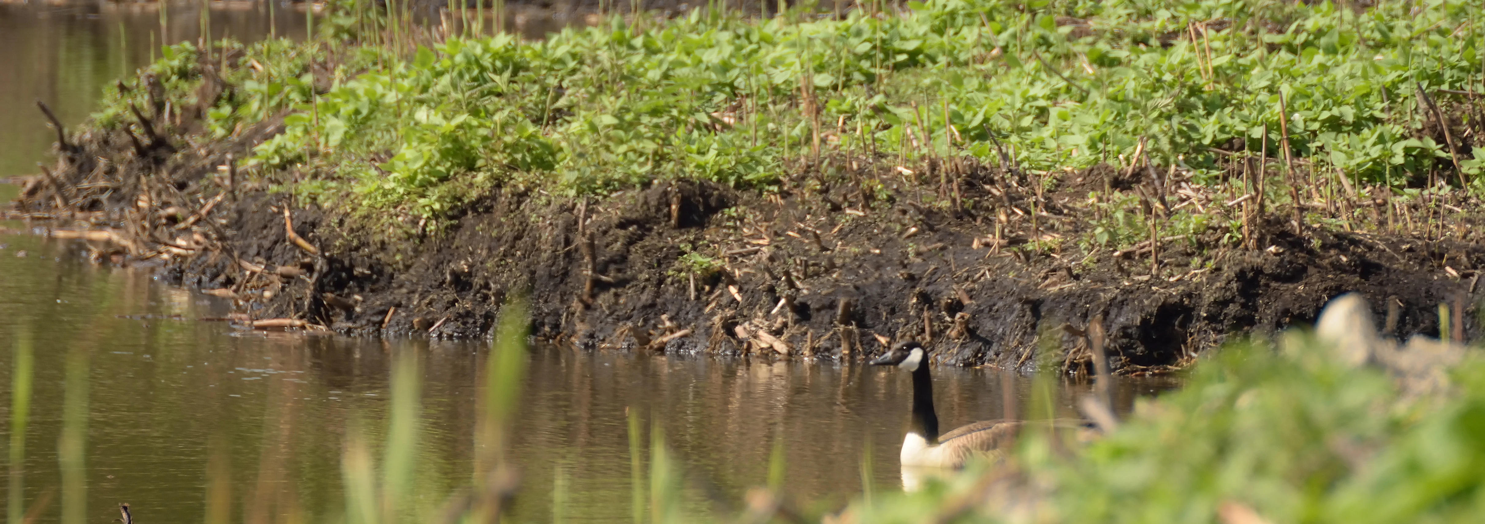
A Canada goose swimming in the water near the muddy, vegetated bank of a marshy area in Pfungstädter Moor.
A Canada goose in the Pfungstädter Moor nature reserve.

Pfungstädter Moor history and protected-area timeline

The defining event in the natural history of the Pfungstädter Moor took place roughly 10,000 years ago. The Neckar river, then passing through what is now the southern Rhine plain, cut a new bed near Heidelberg and abandoned its older channel. The vacated meander slowly silted up, and over centuries its waters gave way to marsh, peat-forming bog, and eventually a steady cover of alder carr forest, establishing the wetland system that survives today.

Human use of the area stretches back into the historical period but has always been modest in scale. Peat was cut from the moor for fuel, and reeds were harvested for thatched roofs and the manufacture of reed-straw mats. Both activities gradually diminished the area's natural waterlogged character. The decision to place the moor under formal protection came on 10 January 1955, when the Hessian authorities designated it as a Naturschutzgebiet. The designation was renewed under updated terms on 29 May 1984 and the boundary was extended on 31 October 1994.

A serious threat emerged in the second half of the twentieth century. The pumping of drinking water from aquifers near and around the reserve steadily lowered the water table, putting the bog at risk of drying out and losing its characteristic plant communities. Restoration planners countered this by introducing Rhine water into the moor through wind-powered scoop wheels, with auxiliary ditches distributing the inflow more evenly. The measures proved effective and have been credited with enabling rare bird species to recolonize the area. In 2007 the Pfungstädter Moor became part of the larger EU Birds Directive site Hessische Altneckarschlingen, formally recognizing its value as bird habitat. To the north of the reserve stands the Tafelberg, a 7-hectare hill built from the closure of a former district landfill in 1986; the landfill had been sited in a previously peat-cut section of the moor and its restoration was declared complete in 2004.

Pfungstädter Moor landscape and geographic character

Pfungstädter Moor sits in a flat landscape typical of the Hessian Rhine plain, but its surface still betrays the curved course of an ancient river. The defining landform is the silted-up Neckar meander, whose former outer bank survives as a well-preserved cut bank, while the inside of the loop has become wetland. Across the rest of the immediate area, agricultural fields and settlements predominate, so the reserve reads as a sudden enclave of wet, semi-wild ground amid drier surroundings.

The reserve contains three quite distinct micro-landscapes. The first is the open Erlensee and its fringing reed beds, where water and emergent vegetation dominate. The second is the surrounding alder carr, where shallow groundwater keeps the soil saturated and the canopy dense enough to create the "almost jungle-like" atmosphere noted in local descriptions. The third is a smaller fragment squeezed between the railway, the A5 autobahn, and the L3303, where the wetland character is narrower but still recognizable. Ditches, both original and modern, help distribute water across these areas and shape the surface into a patchwork of pools, reed stands, and damp woodland.
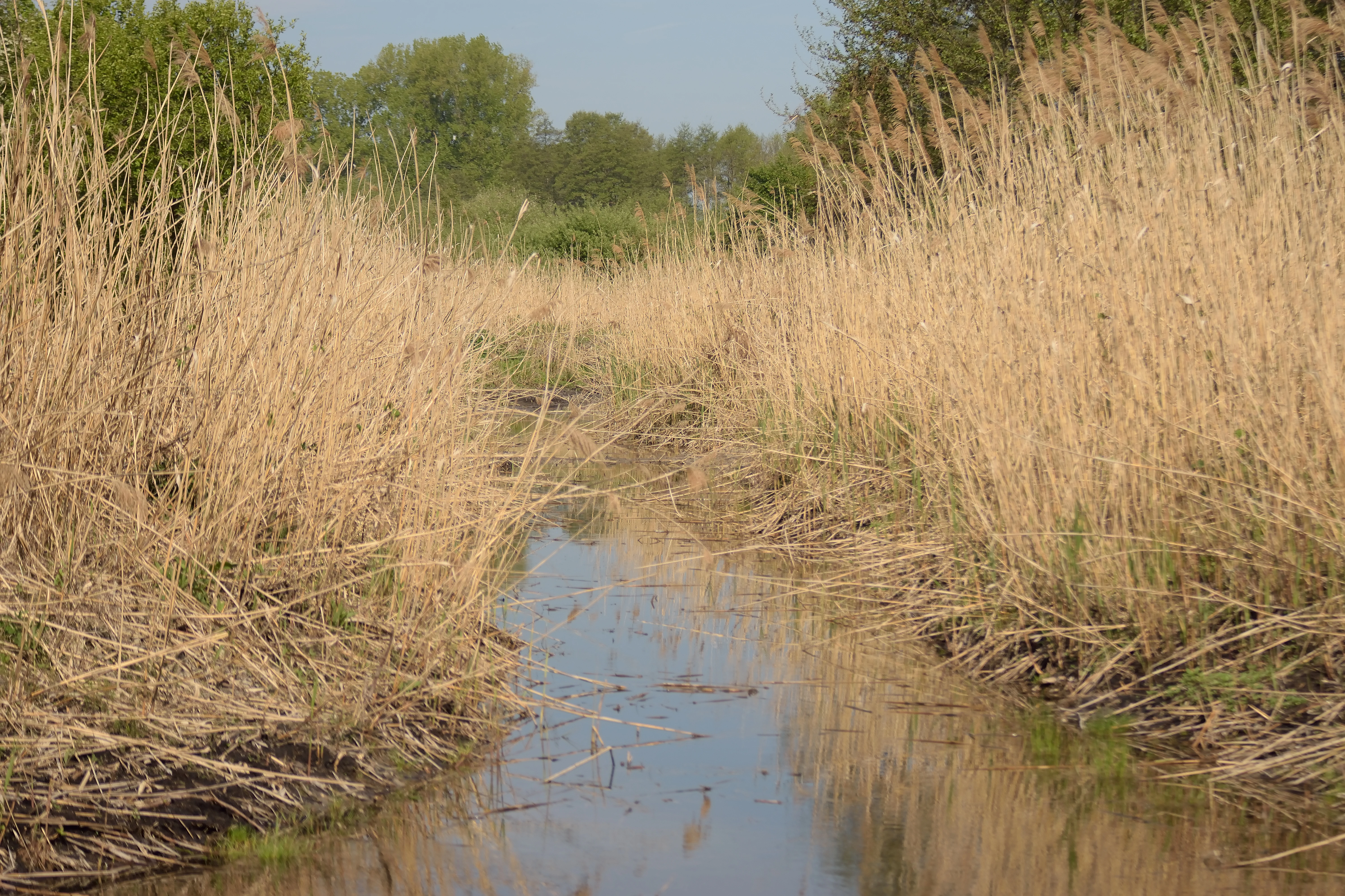
A narrow, still stream flowing through a dense field of tall, dry reeds with green trees visible in the background under a pale sky.
A narrow water channel bordered by tall reeds in the Pfungstädter Moor nature reserve.

Pfungstädter Moor ecosystems, habitats, and plant life

Ecologically, Pfungstädter Moor is a wetland refugium rather than a forest or upland reserve. Its habitat mosaic echoes an entire succession in miniature: abandoned river channel, open water, reed bed, peat bog, and alder carr forest. This compact layering of stages is what gives the reserve its ecological value, because each stage supports specialized plant and animal communities that would not survive in any single habitat on its own.

The waterlogged habitats rest on the relic course of the old Neckar, whose silted channel still determines the shape and moisture pattern of the area. The alder carr is dominated by alder trees adapted to waterlogged soils, and beneath them grow plants that require consistent saturation. The peat bog remnants shelter bog-specialist flora, including the marsh fern (Thelypteris palustris) and the cyperus sedge (Carex pseudocyperus), both of which are noted as characteristic and unusual finds for this region. Open reeds around the Erlensee provide additional structural variety and habitat edges. The combination of bog, carr, reed, and standing water, all in close proximity, allows species to move between complementary habitat types within the reserve.

Pfungstädter Moor wildlife and species highlights

The wetland character of the Pfungstädter Moor is reflected most clearly in its birdlife, which is the focus of much of its modern conservation attention. Reed-nesting and reed-feeding species have established themselves or returned to the reserve as restoration measures have stabilized the water levels. Among the species recorded are the great reed warbler (Drosselrohrsänger), the little bittern (Zwergrohrdommel), and the Eurasian reed warbler (Teichrohrsänger), all of which depend on healthy reed beds and shallow water for feeding and nesting. The integration of the reserve into the larger EU Birds Directive site Hessische Altneckarschlingen in 2007 reflects this ornithological importance.

While the birdlife is the most visible faunal signature, the wetland habitats also support a broader community of invertebrates, amphibians, and other wetland animals typical of lowland bogs and carr forests in central Europe. The mosaic of bog, reed bed, and alder swamp provides structurally diverse conditions within a small area, allowing different animal groups to find suitable microhabitats in close proximity. This diversity of structure is the reason the reserve can support a relatively rich fauna despite its limited size.

Pfungstädter Moor conservation status and protection priorities

Conservation at the Pfungstädter Moor is shaped by an unusual problem: the very feature that makes the reserve valuable, its waterlogged soils, was being lost to activities well outside its boundaries. Lowering of the groundwater table from drinking-water extraction in the wider region had been drying out the bog and threatening its characteristic plant communities. The reserve was therefore redirected toward an active restoration model rather than a passive protection model. Rhine water is now pumped into the moor using wind-powered scoop wheels, with auxiliary ditches distributing the inflow across the protected ground. This engineering-led approach has been credited as the main reason rare bird species have been able to recolonize the site.

Alongside the water management, the area carries formal recognition at multiple levels. It is registered with the World Database on Protected Areas under WDPA ID 82330, is classified as a German Naturschutzgebiet under Hessian law, and is rated as IUCN Category IV (Habitat/Species Management Area) at the international level. Since 2007 it also forms part of the EU Birds Directive site Hessische Altneckarschlingen, linking its conservation status to the wider framework of European protected-area law. Beyond conservation policy, the reserve sits next to the Tafelberg, a former district landfill closed in 1986 and declared restored in 2004, demonstrating the broader reclamation of degraded land along this stretch of the old Neckar.

Pfungstädter Moor cultural meaning and human context

There is no significant indigenous or deeply historic cultural layer associated specifically with the Pfungstädter Moor; the area's cultural identity is more closely tied to the Bergstraße, the long-ancient route and settlement corridor at the edge of the Odenwald, than to the wetland itself. Local cultural references to the moor tend to focus on traditional land uses: peat cutting for fuel and harvesting of reeds for thatched roofs and reed-straw mats. These activities, while modest in scale, link the reserve to centuries of rural economy in the Rhine plain and explain why the moor appears so altered in parts compared with its original wetland nature.

In the modern period, the moor functions more as a local nature experience than as a cultural landmark. Visitor groups such as the local NABU chapter and Natura Trail initiatives frame the area as part of regional nature education, especially through the trail "Pfungstadts Wilder Osten: Von der Düne zum Moor," which routes visitors from nearby sand dune habitats into the moor itself. This helps position the reserve as part of the cultural geography of the Bergstraße lowlands, an area where nature conservation, recreation, and local environmental awareness have become intertwined.

Top sights and standout views in Pfungstädter Moor

The strongest feature of the Pfungstädter Moor is the unusually intact relic of an ancient Neckar river loop, where a well-preserved cut bank and surviving peat bog sit beside a thriving alder carr forest. The reserve is also a textbook case of active wetland restoration, with wind-powered scoop wheels lifting Rhine water back into the moor and visibly reversing decades of groundwater loss. Birdwatchers will find it rewarding for its population of reed-nesting species including great reed warbler, little bittern, and Eurasian reed warbler, while botanists will recognize it as a home for bog-specialist plants like marsh fern and cyperus sedge. The contrast between its dense, almost jungle-like interior and the surrounding open Rhine plain agricultural landscape makes the reserve feel far more remote than its small 97-hectare size would suggest.

Best time to visit Pfungstädter Moor

The most rewarding visits to a wetland reserve such as the Pfungstädter Moor are normally those timed to the warmer half of the year, when reed beds are at full height and bird activity around nesting and feeding is highest. Late spring through summer is generally the best window for hearing reed warblers and observing bitterns in dense vegetation, while the same period also shows bog plants and reed stands at their most distinctive. Autumn can offer quieter conditions and lower water levels in the surrounding landscape, which can make the contrast between the wet reserve and drier surroundings especially striking. Winter visits are possible along the marked paths but offer less of the lush, jungle-like vegetation that defines the reserve in other seasons.

Monthly climate preview

Measured monthly weather patterns and annual temperature variations across representative coordinates

Pfungstädter Moor Climate Normals, Long-Term Temperature and Precipitation Rhythm

Representative coordinates record annual temperatures ranging from sub-zero winter minimums to warm summer maximums alongside consistent daily precipitation averages. Analyzing these twelve-month baseline averages reveals the long-term climatic rhythm that defines the protected landscape.
Annual mean10 °C
0 °C21 °C
Jan
Feb
Mar
Apr10°
May14°
Jun18°
Jul21°
Aug20°
Sep15°
Oct10°
Nov
Dec
Warmest month
July

20.6 °C

Coolest month
January

0.2 °C

Wettest month
July

2.2 mm/day

Driest month
April

1.4 mm/day

Park location guide

Geography guide, regional context, and park location map for Pfungstädter Moor

Pfungstädter Moor park geography, regions, and map view in Germany

Understand where Pfungstädter Moor sits in Germany through a broader geographic reading of the surrounding landscape, nearby location context, and its mapped position within the national park landscape.

How Pfungstädter Moor fits into Germany

Germany is a federal republic in Western and Central Europe with a population of over 83 million across sixteen constituent states. It is Europe's largest economy by nominal GDP and a major global exporter and importer. The capital is Berlin, and the country borders Denmark, Poland, Czech Republic, Austria, Switzerland, France, Luxembourg, Belgium, and the Netherlands.

Wider geography shaping Pfungstädter Moor in Germany

Germany is located in Western and Central Europe, spanning 357,022 km². It borders Denmark to the north, Poland and the Czech Republic to the east, Austria and Switzerland to the south, and France, Luxembourg, Belgium, and the Netherlands to the west. The country has coastlines on the Baltic Sea and North Sea to the north, with the Alps located in the southern region.

Map view of Pfungstädter Moor

Use this park location map to pinpoint Pfungstädter Moor in Germany, understand its exact geographic position, and read its mapped placement within the surrounding landscape more clearly.

Pigeon | © OpenStreetMap contributors

Location context for Pfungstädter Moor

Hessen

Visual reference for wetland habitats, alder carr forests, and ancient river meanders

Pfungstädter Moor Photos and Landscape Scenery in the Hessian Rhine Plain

Visual records reveal the unique terrain of Pfungstädter Moor, highlighting its dense alder carr forests, waterlogged reed beds, and surviving peat bog remnants. Examining these protected habitats provides a clearer understanding of the ancient river meanders and active wetland restoration efforts across the landscape.

A Canada goose swimming in the water near the muddy, vegetated bank of a marshy area in Pfungstädter Moor.

A wide, eye-level landscape view of a nature reserve with a foreground of green grass, midground of reeds and small trees, and background of gentle, hazy hills under a pale sky.

A narrow, still stream flowing through a dense field of tall, dry reeds with green trees visible in the background under a pale sky.

Park atlas

Compare adjacent wetland reserves and connected conservation landscapes across Hesse

Parks Near Pfungstädter Moor and Other Protected Areas in the Surrounding Region

Browsing parks near Pfungstädter Moor reveals a diverse network of regional wetland reserves and protected river valley landscapes. Extending the search provides deeper geographic context for comparing similar lowland habitats across the wider Rhine plain.
A watercolor painting showing a soft, stylized landscape of green meadows, sparse trees, and distant rolling hills against a white background.
Nature reserveHesse
About 2.5 km away#1 closest

South

Im Dulbaum bei Alsbach Nature Reserve: Mapped Inland Dunes and Grassland Geography

A vital protected sandy terrain in the Hessian Rhine Plain

Im Dulbaum bei Alsbach protects a remnant of the historic Rhine graben sand dune belt in southern Hesse. This nature reserve provides essential habitat connectivity for heat-loving species through its distinct calcareous sand grasslands and former quarry terrain, offering a look into the region's complex ecological history.

Area
0.092 km²
Established
1994
IUCN
IV
Relief
Lowland
A soft, delicate watercolor painting depicting a meandering river flowing through a lush, grassy wetland landscape with rolling hills in the background.
Nature reserveHessen
About 2.5 km away#2 closest

Southwest

Altneckarlachen von Alsbach, Hähnlein und Bickenbach: Protected Wetland and River Geography

A rare mosaic of prehistoric river loops in the Hessian Rhine plain

Altneckarlachen von Alsbach, Hähnlein und Bickenbach protects a unique sequence of prehistoric Neckar meanders featuring shallow water zones, reed belts, and black-alder swamp forest. This nature reserve in the Darmstadt-Dieburg district remains a critical wetland sanctuary, preserving a vital ecological cross-section of the ancient Rhine-Neckar landscape and its associated peatland soils.

Area
0.892 km²
Established
1990
IUCN
IV
Relief
Lowland
A horizontal watercolor painting showing a soft, impressionistic landscape with rolling hills, sparse trees, and pale green and pink tones on a white background.
Nature reserveHesse
About 3.1 km away#3 closest

East

Kalksandkiefernwald bei Bickenbach, Pfungstadt und Seeheim-Jugenheim Protected Area Atlas

A rare calcareous sand pine forest in the Hessian Rhine plain

Located in the Darmstadt-Dieburg district, this reserve protects an airy, light-filled woodland on calcareous sandy ground. The terrain is defined by its gentle undulations and historical woodland grazing traces, offering a unique look at forest management in the Rhine plain. Explore the distribution of its two distinct sections, including the specialized sand grass vegetation found along its managed utility corridors.

Area
0.874 km²
Established
1996
IUCN
IV
Relief
Lowland
A pale, soft-toned watercolor painting showing rolling green and golden dunes under a light, hazy sky.
Nature reserveHessen
About 5 km away#4 closest

Northeast

Düne am Ulvenberg von Darmstadt-Eberstadt: Inland Sand Dune Protected Area Geography

A rare Pleistocene dune ecosystem in the Hessen region.

Düne am Ulvenberg von Darmstadt-Eberstadt represents a critical inland dune fragment within the Upper Rhine Graben. This nature reserve provides essential habitat for sand-dwelling flora in a setting defined by its open, dry sandy flats, pine woodland, and specialized steppe-like turf that persists as a unique geological legacy.

Area
0.089 km²
Established
1991
IUCN
IV
A soft watercolor painting of a rolling green hillside with trees, set against a pale, light-colored background.
Nature reserveHessen
About 5.5 km away#5 closest

South

Orbishöhe von Auerbach und Zwingenberg: Geography, Landscape, and Protected Area Mapping

An examination of Hessian quarry-based ecological conservation sites.

The Orbishöhe von Auerbach und Zwingenberg nature reserve serves as a prime example of localized conservation within the Odenwald hills. Its landscape is defined by former quarry faces and open slope terraces, which provide a critical habitat for rare and threatened plant species. This resource offers a clear look at the reserve's topography, physical boundaries, and its broader role within the Natura 2000 network of protected German lands.

Area
0.064 km²
Established
1988
A horizontal watercolor illustration of a soft, hazy landscape featuring light pink blooming trees in a green field, with rolling, misty purple and brown hills in the background.
Nature reserveHesse
About 5.9 km away#6 closest

Southeast

Fuchswiese bei Stettbach: Mapped Nature Reserve and Protected Meadow Landscape in Hesse

Exploring the ecological boundaries of a specialized wet meadow reserve in southern Hesse

Fuchswiese bei Stettbach is a dedicated nature reserve serving as a critical habitat for threatened meadow butterfly species. Located in the Darmstadt-Dieburg district of Hesse, this protected area preserves wet meadow vegetation amidst the northern Odenwald fringe. The site offers a focused view into how small, carefully managed landscapes contribute to the broader ecological health and regional geography of central Germany.

Area
0.03 km²
Established
2010
A soft watercolor painting of a flat, open landscape with scattered trees, rolling grasses, and muted green and pink tones.
Nature reserveHessen
About 6.1 km away#7 closest

Northeast

Lerchenberg und Kernesbellen von Darmstadt-Eberstadt: Hessian Nature Reserve and Dune Atlas

Protected sand grassland and pine forest landscape mapping

Lerchenberg und Kernesbellen von Darmstadt-Eberstadt serves as a key inland dune reserve within the northern Upper Rhine Plain. This protected area features a unique, sun-warmed mosaic of sandy substrates, sparse calcareous forests, and historic orchard meadows. Analyze the site's ecological boundaries and its role as a critical habitat fragment within the broader network of regional protected landscapes.

Area
0.172 km²
Established
1995
IUCN
IV
Watercolor painting showing a stylized, panoramic landscape of rolling hills and forest, depicted in soft green and earth tones against a white background.
Nature reserveHessen
About 7.6 km away#8 closest

Southeast

Felsberg bei Reichenbach Nature Reserve: Geography and Granite Boulder Field Analysis

Protected forest and geological monument in the Odenwald range

Felsberg bei Reichenbach protects 168 hectares of Odenwald mountain slope in Southern Hessen. The site is centered on the Felsenmeer, a dramatic sea of granite boulders created by frost weathering, framed by mixed deciduous woodland. This area functions as an important Natura 2000 habitat, preserving both specialized rock ecosystems and montane forest, providing a clear geographic link between the Lautertal valley and the high slopes of the Felsberg summit.

Area
1.677 km²
Established
1972
IUCN
IV
Relief
Mountain

Common questions about visiting, size, designation, and location context for Pfungstädter Moor

Pfungstädter Moor FAQs for park facts, access, geography, and protected area context

Find quick answers about Pfungstädter Moor, including protected-area facts, park geography, trail and visitor context, and how the park fits into its surrounding country and regional landscape.
MoriAtlas Explorer

Continue Your Protected Areas Search Across the Global Atlas

Deepen your exploration by continuing the structured search for national parks and protected areas worldwide. Utilize the comprehensive filtering capabilities to compare different conservation landscapes and refine your understanding of global park geography. Discover more about the distribution and characteristics of protected natural areas.

Global natural geography