

Mori Atlas logo
State or regional parkPink Mountain Provincial Park

Mapping the ecological transitions and geological significance of the Muskwa Foothills.

Pink Mountain Provincial Park: A Comprehensive Atlas of Protected Alpine Tundra and Fossil Deposits

Pink Mountain Provincial Park serves as a protected sanctuary within the Muskwa Foothills of northeastern British Columbia, rising from dense subalpine forests into rare alpine tundra. This site preserves critical Mesozoic palaeontological records while supporting a diverse assemblage of arctic flora and fauna at the southern edge of their range. The landscape provides essential habitat for large northern herbivores and remains a focal point for understanding the geological and ecological heritage of the Rocky Mountain foothills.

provincial parkpalaeontologyMesozoic fossilsRocky Mountain foothillsMuskwa Foothillssubalpine forest

Pink Mountain Provincial Park

State or regional park

Park overview

Structured park overview, official facts, and landscape profile for Pink Mountain Provincial Park

Pink Mountain Provincial Park park facts, protected area profile, and essential visitor context

Review the core facts for Pink Mountain Provincial Park, including designation, size, terrain, visitor scale, habitats, and operating context in one park-focused overview.

About Pink Mountain Provincial Park

Pink Mountain Provincial Park protects a striking ecological crossroads in one of British Columbia's least-visited corners. Despite covering only about 98 hectares, the park captures the transition between the boreal foothills and the high Rocky Mountain environment, with vegetation climbing from conifer-dominated subalpine forest into a tundra-like summit zone. This vertical change, combined with the unusually rich plant diversity of the exposed ridges, gives the area an outsized significance for wildlife and for scientific study.

At the heart of the park's formal purpose is the protection of a Mesozoic-era palaeontological site. The exposed geology records a time of large ancient fauna, making the mountain a natural archive of much older life than the modern species that today roam the slopes. Sitting in the Muskwa Foothills eco-section of the eastern Rockies, the park represents a piece of northern wilderness that has shifted dramatically in human history, from Indigenous travel and hunting territory to a fur trade corridor and eventually to a modern landscape shaped by the Alaska Highway, forestry, and natural gas development.

For visitors, the appeal lies as much in the experience of driving a forest service road up through switchbacks to expansive alpine viewpoints as in the formal conservation values. The maintained season is limited, with the summit road open only from late spring through fall, and the surrounding region functions as a wildlife viewing destination where large mammals and uncommon arctic butterflies can be observed in a single visit.

Quick facts and research context for Pink Mountain Provincial Park

Pink Mountain Provincial Park is a 98-hectare Class II protected area in British Columbia, managed by BC Parks and established in 1999. It lies in the Muskwa Foothills of the northeastern Rockies, approximately 180 kilometers northwest of Fort St. John and reached via the Alaska Highway corridor.

The park's primary protection role centres on a palaeontological site preserving Mesozoic-era large fauna, while its landscapes span black and white spruce, lodgepole pine, willow, and birch forests transitioning into subalpine and alpine tundra. Wildlife values include montane and northern caribou herds, elk, moose, plains bison, grizzly and black bears, and extremely rare colonies of arctic butterflies at the southern edge of their range.

Protection and recognition

Documented terrestrial protection data and international recognition metrics

Pink Mountain Provincial Park Protection Status and Conservation Scope

Pink Mountain Provincial Park maintains a documented terrestrial protection status within the regional conservation framework. Official records compile designated territory parameters and international recognition sources to support park geography analysis.

Protection details

Protection scope
Terrestrial
Transboundary protection
No
Park context

Deeper park guide and search-rich context for Pink Mountain Provincial Park

Pink Mountain Provincial Park history, landscape, wildlife, and travel context

Explore Pink Mountain Provincial Park through its history, landscape character, ecosystems, wildlife, conservation priorities, cultural context, and seasonal travel timing in a structured park guide built for atlas discovery and search intent.

Why Pink Mountain Provincial Park stands out

Pink Mountain Provincial Park is best known for two distinct natural treasures. The first is a significant Mesozoic-era palaeontological site that preserves evidence of large ancient fauna and is the formal basis for the park's protection designation. The second is the unusual concentration of arctic and alpine plants on the mountain's open slopes, which supports an internationally recognised population of arctic butterflies at the southernmost edge of their distribution. The park is also notable for sustaining important habitat for northern herbivores, including vulnerable Pink Mountain caribou, elk, moose, and a thriving introduced population of plains bison.

Pink Mountain Provincial Park history and protected-area timeline

The land that now makes up Pink Mountain Provincial Park has a layered human history. Before formal protection, the area was traditionally used by the Sekani and Dunneza (Beaver) First Nations, who knew the foothills as hunting and travel territory. In the late 18th century, European fur trappers, traders, and explorers began moving through northeastern British Columbia, and fur trading posts were established at nearby communities including Fort St. John, Hudson's Hope, and Fort Nelson.

The mid-twentieth century brought a new phase of accessibility. The Alaska Highway was built in 1943, opening up the region and encouraging logging and natural gas exploration. Improved roads also made it easier for the public to reach Pink Mountain, drawn by the area's unusual wildlife concentrations. In 1997, the Fort St. John Land and Resource Management Plan recommended the area for formal protection, and in 1999 it was designated as a provincial park. The park's primary role was defined around safeguarding a significant Mesozoic-era palaeontological site containing large fauna, while also continuing to serve as a refuge for big game and the rare arctic butterflies found on the upper slopes.

Pink Mountain Provincial Park landscape and geographic character

The park's landscape is shaped by the eastern foothills of the Rocky Mountains, specifically within the Muskwa Foothills eco-section. Elevations range across a vertical transition from forested valleys to exposed ridges, with the subalpine zone sitting roughly between 1,100 and 1,550 meters. In this zone, black and white spruce, lodgepole pine, willow, and birch dominate the slopes, forming the characteristic mixed-conifer cover of the northeastern Rockies.

Above 1,550 meters, the terrain opens into alpine tundra. Shrubs, herbs, mosses, and lichens take over from the trees, and the exposed slopes become a mosaic of low-growing vegetation. It is on these open ridges that Pink Mountain earns its reputation for unusually diverse arctic and alpine plant communities; peaks of similar elevation in the same general region do not show the same concentration of cold-adapted flora. The combination of forest below and tundra above, along with the broad sweep of the foothills, creates a landscape that is visually dramatic and ecologically layered.

Pink Mountain Provincial Park ecosystems, habitats, and plant life

The vegetation of Pink Mountain moves in clear bands as elevation increases. At lower subalpine levels, the forest is dominated by hardy conifers, particularly black and white spruce and lodgepole pine, mixed with willow and birch thickets. As the slopes climb toward the summit, the trees thin out and give way to the open tundra community of shrubs, herbs, mosses, and lichens that define the alpine zone.

This vertical sequence is ecologically important because of what happens in the tundra. The matchless concentration and variety of arctic/alpine plants on Pink Mountain support a plant community more typical of far higher latitudes, giving the mountain an unusual botanical character for its elevation and location. These plant communities in turn support an unusually dense and varied insect fauna, which feeds upward through the food web and helps explain why the broader mountain sustains such a wide range of mammal species across such a small protected footprint.

Pink Mountain Provincial Park wildlife and species highlights

Wildlife is one of the defining features of Pink Mountain Provincial Park. The slopes and surrounding country support large herbivores including caribou, elk, and moose, as well as plains bison, a relative newcomer that was introduced to the area in 1968 and has since thrived. The caribou herd associated with Pink Mountain, sometimes referred to as the Sikanni Chief, Prophet River, and similar names, are part of the Northern Mountain Population and are classified as vulnerable in Canada and blue-listed as a species of special concern in British Columbia.

Predators and other carnivores follow the herds into the park and surrounding land. Significant species recorded in the area include grizzly bear, black bear, lynx, fisher, and wolverine, making the broader Pink Mountain landscape part of an intact northern predator-prey system. The park is also internationally recognised for arctic butterflies, which reach their southernmost distributional limit here, drawn to the area by the unmatched concentration of tundra plants. The combination of large mammals, predators, and rare cold-adapted insects gives Pink Mountain an unusually complete wildlife profile for a park of its size.

Pink Mountain Provincial Park conservation status and protection priorities

Pink Mountain Provincial Park's conservation role is built on multiple, reinforcing values. The formal designation centres on the protection of a significant Mesozoic-era palaeontological site containing examples of large ancient fauna, an unusual basis for a small provincial park and one that gives the site long-term scientific importance beyond its modern ecosystems.

At the same time, the park protects important habitat for vulnerable northern wildlife. The Pink Mountain caribou herd has been listed as vulnerable by COSEWIC and is provincially blue-listed, with population estimates documenting a decline from around 1,300 animals in 1996 to roughly 850 by 2002. By safeguarding subalpine forest, alpine tundra, and the rich mosaic of tundra plants that draws arctic butterflies, the park contributes to the maintenance of habitat for threatened herbivores, their predators, and one of the southernmost strongholds for a distinctive arctic insect fauna. The Muskwa Foothills location also places the park within a broader ecological landscape historically shaped by Indigenous land use, fur trade routes, and modern resource development, making its protected status an important counterweight to regional industrial pressures.

Pink Mountain Provincial Park cultural meaning and human context

Pink Mountain sits within a landscape that holds generations of human history. Before European contact, the foothills and surrounding valleys were used traditionally by the Sekani and Dunneza (Beaver) First Nations, who travelled, hunted, and lived across this northeastern corner of British Columbia. The foothills later became part of the late 18th-century European fur trade network, with nearby fur trading posts established at Fort St. John, Hudson's Hope, and Fort Nelson as trappers, traders, and explorers moved through the region.

The arrival of the Alaska Highway in 1943 transformed the area, opening it up to forestry, natural gas exploration, and public travel. Yet the post-1943 era did not erase earlier layers of connection, and the modern provincial park designation reflects both an interest in safeguarding natural features and an awareness of the land's deeper history of human use.

Top sights and standout views in Pink Mountain Provincial Park

The compact scale of Pink Mountain Provincial Park belies its ecological importance. A major highlight is the protected Mesozoic palaeontological site, which preserves evidence of large ancient fauna and gives the park a foundational scientific value.

Equally distinctive is the concentration of arctic and alpine plant life on the open slopes, which supports arctic butterflies at the southern limit of their range and gives the tundra community an unusually rich character. Large mammals, including vulnerable caribou, elk, moose, and a thriving introduced population of plains bison, share these slopes with grizzly and black bears, lynx, fisher, and wolverines, creating a complete northern wildlife profile within a small protected footprint above the Muskwa Foothills.

Best time to visit Pink Mountain Provincial Park

Pink Mountain's character shifts with the seasons in ways that are central to any visit. Late spring through fall is the practical window for reaching the summit road, which is not maintained in winter and is accessible by vehicle only from late spring to fall. Summer and early fall offer the most complete experience, when the subalpine forest is fully accessible, the tundra plants are in their prime growth, and arctic butterfly activity peaks on the exposed ridges.

Winter access to the upper mountain is limited, but the foothills and lower forest still offer wildlife viewing opportunities in colder months. Those seeking the fullest expression of the park, including the tundra flora and the wide-ranging mammals and arctic butterflies, will find the late-spring to early-fall window the most rewarding.
Monthly climate preview

Examine long-term average temperature ranges and precipitation metrics across twelve months

Pink Mountain Provincial Park Climate Normals and Annual Weather Patterns

Representative coordinate records for Pink Mountain Provincial Park outline a measured annual progression of average temperatures from deep winter sub-zero lows to moderate summer maximums alongside varying monthly precipitation rates. Detailed long-term data files provide complete monthly averages to support broader regional weather comparisons across the protected terrain.
Annual mean-3 °C
-14 °C11 °C
Jan-14°
Feb-13°
Mar-10°
Apr-4°
May
Jun
Jul11°
Aug10°
Sep
Oct-2°
Nov-10°
Dec-14°
Warmest month
July

11 °C

Coolest month
January

-14.4 °C

Wettest month
June

4.4 mm/day

Driest month
February

1.1 mm/day

Park location guide

Geography guide, regional context, and park location map for Pink Mountain Provincial Park

Pink Mountain Provincial Park park geography, regions, and map view in Canada

Understand where Pink Mountain Provincial Park sits in Canada through a broader geographic reading of the surrounding landscape, nearby location context, and its mapped position within the national park landscape.

How Pink Mountain Provincial Park fits into Canada

Canada is a federal parliamentary constitutional monarchy spanning North America from the Atlantic to the Pacific and Arctic Oceans. With a population of over 41 million, it is officially bilingual in English and French at the federal level. The country gained independence from the United Kingdom through a gradual process culminating in 1982.

Wider geography shaping Pink Mountain Provincial Park in Canada

Canada occupies the northern portion of North America, sharing its longest international border with the United States. The country extends from the Atlantic Ocean to the Pacific Ocean and northward into the Arctic Ocean, giving it the longest coastline of any nation.

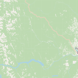
Map view of Pink Mountain Provincial Park

Use this park location map to pinpoint Pink Mountain Provincial Park in Canada, understand its exact geographic position, and read its mapped placement within the surrounding landscape more clearly.

Pigeon | © OpenStreetMap contributors

Location context for Pink Mountain Provincial Park

British Columbia
Park atlas

Compare regional park geography and connected protected areas across the Muskwa Foothills

Parks Near Pink Mountain Provincial Park and Surrounding Protected Landscapes

Continue exploring regional park geography and adjacent protected areas in the eastern foothills of the Rocky Mountains. Comparing nearby conservation landscapes provides broader context for the subalpine terrain and wildlife habitats surrounding Pink Mountain Provincial Park.
State or regional parkBritish Columbia
About 45 km away#1 closest

Northwest

Redfern-Keily Provincial Park: A Deep Dive into Muskwa Ranges Protected Geography

Remote Glacial Landscapes and Northern Wilderness Terrain

Redfern-Keily Provincial Park encompasses a significant stretch of remote wilderness in the Muskwa Ranges of northeastern British Columbia. Anchored by the eight-kilometer Redfern Lake and surrounding glaciers like the Ithaca and Achaean, the area serves as a primary example of intact boreal and subalpine geography. The terrain offers a rugged look at high-elevation ecosystems and glacial history within the Muskwa-Kechika Management Area.

Area
807.12 km²
Established
1999
IUCN
II
Relief
Mountain
State or regional parkBritish Columbia
About 46 km away#2 closest

Southwest

Graham-Laurier Provincial Park: Protected Boreal Landscape and Geographic Context

Remote wilderness exploration in the Peace River region

Graham-Laurier Provincial Park represents a massive, intact wilderness area in northeastern British Columbia. Defined by boreal forests, undulating ridges, and the cascading waters of Christina Falls, this region serves as a crucial natural refuge within the Muskwa-Kechika Management Area. Access is centered on rugged forest service roads and backcountry trails, making the area a primary destination for self-reliant exploration and terrain study.

Area
999.82 km²
Established
1999
IUCN
II
Relief
Mountain
State or regional parkBritish Columbia
About 95 km away#3 closest

Northwest

Prophet River Hot Springs Provincial Park: Protected Landscape and Geothermal Geography

Remote backcountry wilderness in northeastern British Columbia

Prophet River Hot Springs Provincial Park is a specialized protected area known for its unique tufa mounds and geothermal features. Set against the mountainous backdrop of the Muskwa Ranges, this backcountry destination offers a compelling study of boreal and subalpine geography, accessible only by hiking or horseback through undisturbed wilderness corridors.

Area
1.84 km²
Established
1999
IUCN
II
Relief
Mountain
State or regional parkBritish Columbia
About 127 km away#4 closest

Northwest

Kwadacha Wilderness Provincial Park: Geographic Boundaries and Regional Protected Area Context

Untouched mountain wilderness in northern British Columbia

Kwadacha Wilderness Provincial Park provides a rare, roadless mountain experience within the northeastern interior of British Columbia. Characterized by high-relief alpine ridges, dense boreal forests, and challenging river systems, the park represents an essential wilderness corridor that remains free from human infrastructure and standard road access, prioritizing ecological integrity over recreation.

Area
1,302.79 km²
Established
1973
IUCN
Ib
Relief
Mountain
Watercolor painting of a long truss bridge spanning a river winding through a valley with hills and trees in the background.
State or regional parkBritish Columbia
About 189 km away#5 closest

Southeast

Kiskatinaw Provincial Park: A Protected Landscape Along the Historic Alaska Highway

Geography and heritage in the Peace River region of British Columbia

Kiskatinaw Provincial Park encompasses a distinctive horseshoe meander of the Kiskatinaw River, creating a deep gorge carved into the terrain of northeastern British Columbia. This protected area serves as a focal point for understanding both the river geomorphology of the Peace River Country and the engineering history of the original Alaska Highway, exemplified by the iconic 1942 wooden trestle bridge.

Area
0.58 km²
Established
1962
IUCN
II
Relief
Upland
State or regional parkBritish Columbia
About 207 km away#6 closest

West

Finlay-Russel Provincial Park and Protected Area: Mapping Northern British Columbia Wilderness

A remote river corridor in the Muskwa-Kechika Management Area.

Located in northern British Columbia, Finlay-Russel Provincial Park and Protected Area preserves an essential 85-kilometre river corridor along the Finlay River. This expansive wilderness territory serves as an integral part of the Muskwa-Kechika Management Area, showcasing deep boreal forest landscapes and rugged river valley terrain far from established road networks.

Area
1,092.05 km²
Established
2001
IUCN
II
Access
Remote access
State or regional parkBritish Columbia
About 242 km away#7 closest

North

Jackpine Remnant Provincial Park: Protected Boreal Landscape and Regional Map Context

Conservation and terrain data for the Fort Nelson region

Jackpine Remnant Provincial Park provides a critical study in northern conservation geography. Located in the Fort Nelson area of British Columbia, this 148-hectare site protects a rare stand of jack pine trees. Its mapped boundaries and boreal forest terrain offer a focused look at small-scale protected landscapes and their significance within the broader regional ecosystem of the Canadian north.

Area
1.48 km²
Established
2001
IUCN
II
Relief
Lowland
State or regional parkBritish Columbia
About 252 km away#8 closest

Northwest

Dune Za Keyih Provincial Park and Protected Area: Watershed and Terrain Geography

Remote wilderness landscape in northern British Columbia

Dune Za Keyih Provincial Park and Protected Area protects the largest unlogged watershed in British Columbia. Situated within the Muskwa-Kechika Management Area, this remote wilderness is defined by the geological structures of the Rocky Mountain Trench, providing a continuous corridor of undisturbed mountain forest, riparian zones, and highland terrain.

Area
3,468.33 km²
Established
2001
IUCN
Ib
Relief
Mountain

Common questions about visiting, size, designation, and location context for Pink Mountain Provincial Park

Pink Mountain Provincial Park FAQs for park facts, access, geography, and protected area context

Find quick answers about Pink Mountain Provincial Park, including protected-area facts, park geography, trail and visitor context, and how the park fits into its surrounding country and regional landscape.
MoriAtlas Explorer

Continue Your Protected Areas Search Across the Global Atlas

Deepen your exploration by continuing the structured search for national parks and protected areas worldwide. Utilize the comprehensive filtering capabilities to compare different conservation landscapes and refine your understanding of global park geography. Discover more about the distribution and characteristics of protected natural areas.

Global natural geography