Mori Atlas logo
Nature reservePomezní rybník

Mapping the borderland wetland ecology and transitional terrain within Karlovarský kraj

Pomezní rybník Nature Reserve: A Detailed Geographic and Protected Landscape Atlas Entry

Pomezní rybník serves as a critical wetland biocenter situated in the western Czech Republic. This nature reserve, straddling the international border with Germany, offers a study in transitional habitats that connect the flat Cheb Basin with the rising Smrčiny highlands. The protected area preserves a complex mosaic of open water, marshy margins, and bog-like vegetation that supports rare flora and specialized amphibian populations.

wetland reservebog habitatpondborder protection siteKarlovarský krajCheb district

Pomezní rybník

Nature reserve

Park overview

Structured park overview, official facts, and landscape profile for Pomezní rybník

Pomezní rybník park facts, protected area profile, and essential visitor context

Review the core facts for Pomezní rybník, including designation, size, terrain, visitor scale, habitats, and operating context in one park-focused overview.

About Pomezní rybník

Pomezní rybník is a small but ecologically focused nature reserve in western Bohemia, in the part of the Czech Republic where the country meets the German frontier. It belongs to the Karlovarský kraj and lies within the Cheb district, near the village of Pomezí nad Ohří. Because the reserve is built around an artificial pond whose surface is crossed by the international border, the protected site is as notable for its geographic peculiarity as for its natural values.

Although its area of around 1.76 hectares is extremely limited, the reserve punches above its size ecologically. It was declared a nature reserve in 1990 specifically to preserve the pond, the inflowing watercourse, and the surrounding wetland communities that have developed along the margins. Together these elements form a functioning biocenter, providing habitat for a suite of moisture-dependent species that would otherwise struggle in the broader agricultural and forested landscape of the Cheb Basin.

The reserve occupies a transitional landscape between two geomorphological regions. The northern section, which contains the main pond itself, lies in the Chebská pánev, a basin characterized by flatter terrain and historically wetter conditions. The southern portion extends upward into the Smrčiny, a highland area where slopes, forest, and peaty patches create a different set of microhabitats. This combination of lowland basin and rising highland edge gives the reserve a layered character: open water, marshy shore, peat-influenced vegetation, and surrounding woodland all occur within a short distance.

For visitors and researchers, Pomezní rybník illustrates how a tiny, man-made water body, if left undisturbed and paired with appropriate buffer habitats, can become a refuge for rare wetland and bog flora. The site's protected status reflects a deliberate decision to set aside a small parcel of land to ensure that its specialized plant communities and the amphibians tied to them can survive in an otherwise heavily used borderland region.

Quick facts and research context for Pomezní rybník

Pomezní rybník is a nature reserve (přírodní rezervace) established on 1 October 1990 in the Karlovarský kraj of the Czech Republic, within the Cheb district and the municipality of Pomezí nad Ohří. The protected area covers roughly 1.76 hectares and is administered through the regional authority of the Karlovarský kraj.

The reserve sits at an elevation of about 453–456 meters above sea level and straddles the international boundary with Germany, so the Czech–German state border runs through the central pond. It functions as a registered biocenter, combining an artificial water body with surrounding wetland and bog-like communities that support rare flora and amphibians.

Protection and recognition

Documented terrestrial protection scope and conservation status details

Pomezní rybník Protection Status and International Recognition Facts

Pomezní rybník features a documented terrestrial protection scope defining its conservation framework and management boundaries. Structured records organize baseline designation facts and international recognition data for this protected area.

Protection details

Protection scope
Terrestrial
Park context

Deeper park guide and search-rich context for Pomezní rybník

Pomezní rybník history, landscape, wildlife, and travel context

Explore Pomezní rybník through its history, landscape character, ecosystems, wildlife, conservation priorities, cultural context, and seasonal travel timing in a structured park guide built for atlas discovery and search intent.

Why Pomezní rybník stands out

Pomezní rybník is best known as a compact wetland reserve where the Czech, German border literally cuts through the central pond, creating an unusual cross-border protected site in the westernmost part of the Czech Republic. Its botanical importance is the main reason for protection: the reserve hosts a notable assemblage of rare and threatened wetland and bog species, with the water arum (Calla palustris) as its signature plant. The site is also appreciated for its combination of open water, marshy margins, and the transition between the low-lying Cheb Basin and the rising Smrčiny landscape.
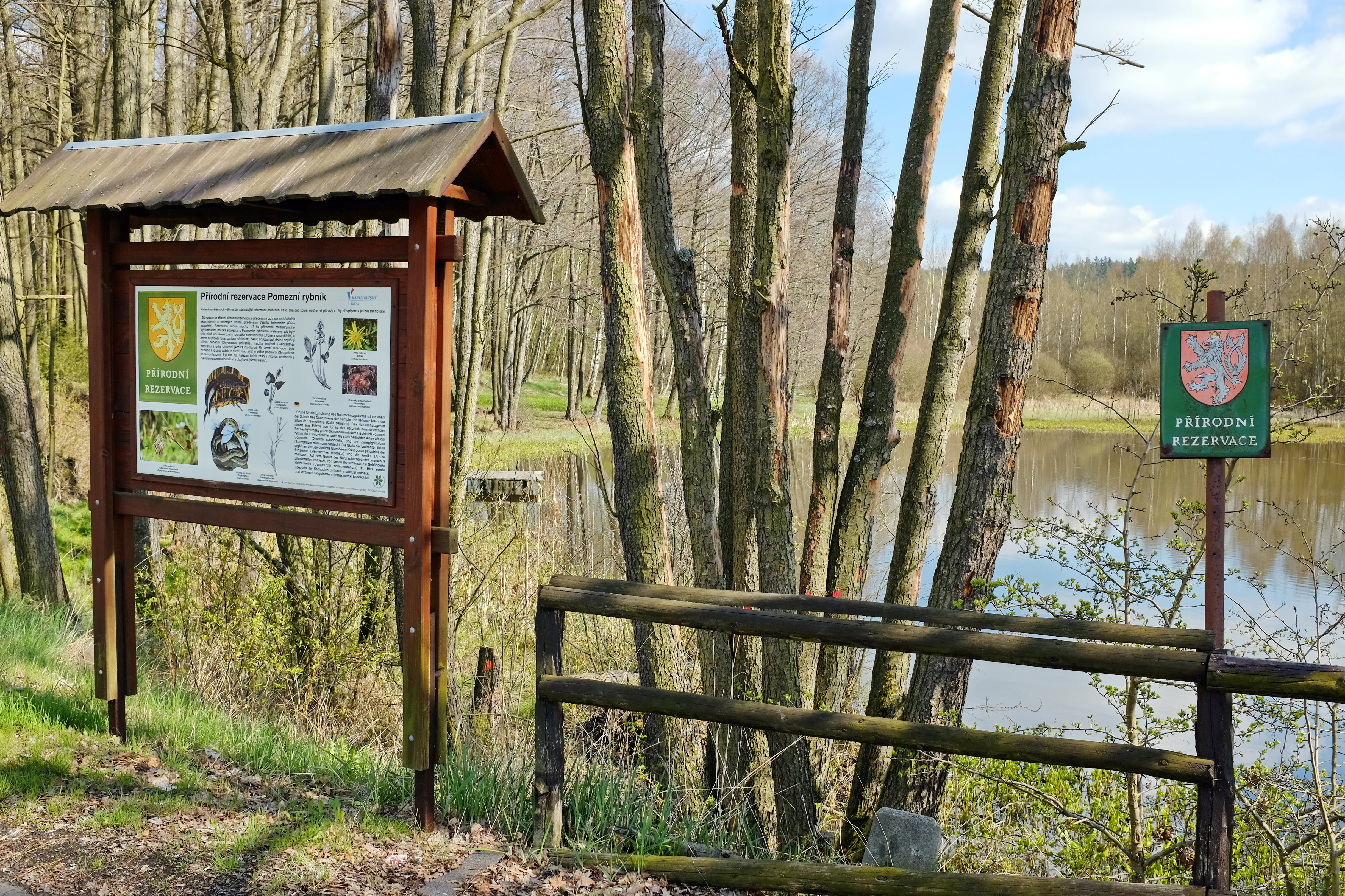
An informational wooden sign stand and a smaller green nature reserve sign stand positioned near the edge of a pond, surrounded by trees.
Informational signage at the Pomezní rybník nature reserve, featuring details about the local ecosystem and a state protected area emblem.

Pomezní rybník history and protected-area timeline

Pomezní rybník was established as a protected nature reserve on 1 October 1990, marking the formal recognition that this small borderland pond and its associated wetlands held unusual ecological value. The reserve was created as part of the broader Czech effort to identify and protect representative examples of the country's wetland and bog habitats, many of which had been shrinking as traditional land use patterns shifted.

Although the pond itself is artificial, the decision to protect it grew out of the recognition that the surrounding wetland communities had developed significant botanical richness over time. By the late twentieth century, the site had become an important refuge for several threatened aquatic and bog species, and the 1990 designation secured the area from activities that might have damaged these sensitive habitats.

Since its declaration, the reserve has been administered through the regional structures responsible for protected areas in the Karlovarský kraj, with broader coordination provided by the Czech Nature Conservation Agency. The protected status has helped maintain the pond and its marginal communities in a condition that continues to support rare flora and amphibians characteristic of Central European wetland systems.

Pomezní rybník landscape and geographic character

The landscape of Pomezní rybník is defined more by water and moisture than by dramatic relief. The reserve occupies a low-lying portion of the Chebská pánev in its northern half, where the flat basin floor supports the central pond and its marshy margins. This basin context gives the site its gentle topography and contributes to the accumulation of water that sustains wetland communities.

To the south, the terrain rises into the foothills of the Smrčiny, a highland region that introduces slopes, mixed forest cover, and localized peat-influenced ground. The transition from basin to highland happens within the reserve itself, producing a compact mosaic of habitats: still water at the pond's center, saturated marsh along its edges, and drier, wooded ground on the higher southern margin.

The borderland character of the site, with the Czech Republic on one side and Germany on the other, adds a subtle but distinctive geographic note. The state boundary running through the pond reinforces the sense of a quiet, peripheral landscape, where small-scale natural features have been left undisturbed enough to support specialized communities.

Pomezní rybník ecosystems, habitats, and plant life

Ecologically, Pomezní rybník is a wetland-dominated site whose value comes from a tight concentration of rare and moisture-dependent species rather than from habitat extent. The reserve protects a sequence of interconnected environments: the open water of the pond, the marshy and boggy margins that fringe it, and the wet woodland and peat-influenced slopes that rise to the south. This layering allows species with very specific hydrological requirements to persist within a small footprint.

The plant communities at the site reflect the classical composition of Central European bog and marsh ecosystems. Aquatic and semi-aquatic species grow in and around the pond, while peat-loving plants occupy the saturated soils of the surrounding transition zone. The vegetation pattern is typical of lowland bog fragments that survive in protected pockets of an otherwise drier regional landscape.

The reserve's designation as a biocenter reflects its role in maintaining viable populations of species that depend on stable, undisturbed wetland conditions. By guarding both the pond and its surrounding moisture gradient, the reserve ensures that the ecological processes linking water level, soil chemistry, and plant composition can continue operating with minimal external disruption.

Pomezní rybník wildlife and species highlights

Pomezní rybník is best understood through its rare and threatened flora, which forms the core of its conservation interest. The reserve's signature species is the water arum (Calla palustris), a wetland plant strongly associated with bog-marsh environments and a key reason the site received protection.

Alongside it grows a notable suite of other rare moisture-loving plants, including bogbean (Menyanthes trifoliata), alpine pondweed (Potamogeton alpinus), round-leaved sundew (Drosera rotundifolia), arnica (Arnica montana), bog cranberry (Vaccinium oxycoccos), least bur-reed (Sparganium natans), and marsh cinquefoil (Potentilla palustris). Together these species point to a habitat mosaic that combines open water, acidic bog-like margins, and wet peaty ground.

On the animal side, the reserve supports amphibians typical of Central European lowland wetlands. The great crested newt (Triturus cristatus), a strongly threatened species, is present in the pond and its surroundings, along with the common toad (Bufo bufo) and additional frog species. The combination of stable water levels, sheltered margins, and limited disturbance makes the site a useful breeding and sheltering habitat for these moisture-dependent amphibians.

Pomezní rybník conservation status and protection priorities

Pomezní rybník holds conservation significance well beyond its tiny footprint because it concentrates a rare combination of bog and wetland features in a region where such habitats are scarce and fragmented. By protecting the pond and the surrounding marsh and bog communities as a single unit, the reserve preserves not just individual species but the ecological relationships among open water, saturated soils, and bog vegetation that sustain them.

The site is recognized as a biocenter within the Czech system of protected areas, a designation that highlights its role as a core node in the regional network of natural habitats. The 1990 declaration as a nature reserve gave the site permanent protection against activities such as drainage, intensive water-level changes, or conversion that could damage its sensitive plant communities.

Although the reserve is small, its cross-border character adds a further layer of conservation value. The pond straddles the Czech–German state boundary, which means the surrounding landscape on both sides matters for the long-term integrity of the habitats. Protecting Pomezní rybník therefore contributes to maintaining a transboundary wetland refuge in an otherwise heavily modified agricultural and forested border region.

Pomezní rybník cultural meaning and human context

Pomezní rybník does not carry a strong, distinctive cultural or historical narrative beyond its identity as a quiet borderland site. The pond itself is artificial, reflecting the long tradition of small water management in the western Czech countryside, but the source material does not provide specific details about its construction, period, or historical use.

The reserve's location near the German border and within the former Sudetenland fringes of western Bohemia situates it in a region shaped by twentieth-century population shifts, agricultural restructuring, and the gradual rewilding of marginal land. This broader background explains why small, formerly worked sites like Pomezní rybník were available for protection in 1990, but the source does not develop these themes in detail, and so culturalContext is best treated lightly.

Top sights and standout views in Pomezní rybník

The standout features of Pomezní rybník are its compact size, its cross-border position, and its concentration of rare wetland and bog flora. The pond lying on the Czech–German border is unusual and gives the site a distinctive geographic identity. Ecologically, the presence of water arum alongside a suite of other rare bog species such as round-leaved sundew, bogbean, and alpine pondweed sets the reserve apart from typical lowland ponds in the region.

Equally important is the site's character as a functioning biocenter: despite covering only about 1.76 hectares, it offers a complete sequence of pond, marsh, and bog-margin habitats, providing stable conditions for threatened amphibians including the great crested newt. This compact but complete ecological package is the reserve's defining quality.

Best time to visit Pomezní rybník

Because Pomezní rybník is a small wetland reserve rather than a destination with seasonal access infrastructure, the timing of a visit is shaped mainly by the visibility of its flora and amphibians. Late spring and early summer are typically the best periods for observing wetland vegetation at its peak and for hearing amphibian choruses around the pond margins, when great crested newts, common toads, and frogs are most active.

Late summer and early autumn can also be rewarding for visitors interested in the bog-associated plants, when flowering and fruiting structures of species such as round-leaved sundew and bog cranberry are most apparent. Winter visits offer a quiet, atmospheric experience of the borderland pond, though botanical interest is limited. The site's small size and conservation status mean visitors should plan for low-impact, short walks rather than extended hiking.

Monthly climate preview

Long-term temperature and precipitation patterns across the year

Pomezní rybník Climate Normals and Monthly Weather Statistics

Historical climate records for Pomezní rybník track measured monthly temperature swings from sub-zero winter lows to warm summer maximums alongside steady precipitation rates. Reviewing the complete twelve-month climatology dataset reveals comprehensive monthly averages captured across the protected landscape coordinate.
Annual mean7 °C
-3 °C18 °C
Jan-3°
Feb-2°
Mar
Apr
May12°
Jun16°
Jul18°
Aug18°
Sep13°
Oct
Nov
Dec-2°
Warmest month
July

17.8 °C

Coolest month
January

-3.1 °C

Wettest month
July

2.7 mm/day

Driest month
April

1.4 mm/day

Park location guide

Geography guide, regional context, and park location map for Pomezní rybník

Pomezní rybník park geography, regions, and map view in Czechia

Understand where Pomezní rybník sits in Czechia through a broader geographic reading of the surrounding landscape, nearby location context, and its mapped position within the national park landscape.

How Pomezní rybník fits into Czechia

Czech Republic is a landlocked Central European country with a population of approximately 10.9 million people. The nation was established as an independent state on January 1, 1993, following the dissolution of Czechoslovakia. Its capital and largest city is Prague, with other major urban centers including Brno, Ostrava, Plzeň, and Liberec.

Wider geography shaping Pomezní rybník in Czechia

The Czech Republic is a landlocked country in Central Europe. It is bordered by Germany to the west, Austria to the south, Poland to the northeast, and Slovakia to the southeast. The landscape is predominantly hilly, with the territory covering 78,871 square kilometers.

Map view of Pomezní rybník

Use this park location map to pinpoint Pomezní rybník in Czechia, understand its exact geographic position, and read its mapped placement within the surrounding landscape more clearly.

Pigeon | © OpenStreetMap contributors

Location context for Pomezní rybník

Karlovarský kraj

Visual reference for the borderland pond, marsh habitats, and transitional Smrčiny terrain.

Pomezní rybník Photos, Landscapes, and Wetland Scenery

Photographic records reveal the intact wetland communities, open water, and bog margins defining Pomezní rybník. Visual documentation helps researchers study the transitional habitats and quiet border terrain spanning the Czech and German boundary.

An informational wooden sign stand and a smaller green nature reserve sign stand positioned near the edge of a pond, surrounded by trees.

Park atlas

Compare adjacent wetland reserves and regional borderland conservation areas

Other Parks Near Pomezní Rybník and Surrounding Protected Landscapes

Browse protected areas near Pomezní rybník to examine similar wetland habitats, lowland basins, and highland terrain across the western border region. Expanding the geographic scope reveals connected ecological zones and contextualizes local conservation features within wider regional geography.
Natural monumentKarlovarský kraj
About 15 km away#1 closest

North

Vernéřovské doly Natural Monument: A Geological Landmark in the Karlovarský kraj

Rare pegmatite mineralogy and historic mining terrain in western Czechia.

Located in the Cheb District, Vernéřovské doly functions as a specialized natural monument dedicated to preserving a quartz-amblygonite-microcline vein system. This protected area provides a window into hydrothermal ore formation, featuring geological structures comparable only to sites in Portugal and the Ural Mountains.

Area
0.003 km²
Established
1999
IUCN
III
Relief
Upland
Protected landscapeBavaria
About 26 km away#2 closest

South

Naturpark Nördlicher Oberpfälzer Wald: Protected Landscape and Regional Geography Map

Forested upland terrain and volcanic geology in Bavaria

Explore the structured geography of Naturpark Nördlicher Oberpfälzer Wald, a massive protected region in Bavaria. This detailed profile highlights the park's characteristic ridge and valley terrain, volcanic basalt landmarks, and its role as a vital ecological belt along the international border.

Area
1,380 km²
Water
Minor water
Watercolor painting of columnar basalt formations surrounded by a pine forest and soft, layered hills in the background.
Natural monumentKarlovarský kraj
About 33 km away#3 closest

Northeast

Rotava Natural Monument: Geological Landforms and Basalt Outcrops in the Karlovarský kraj Region

Protected volcanic terrain and rare botanical habitats in the Czech Republic

Rotava Natural Monument showcases remarkable vertical basalt columns formed by ancient volcanic activity. Located in the Karlovarský kraj region, this site provides a dense, concentrated look at columnar jointing and the specific meadow flora that thrives in its mineral-rich, acidic soil conditions, serving as a landmark for regional geological study.

Area
0.003 km²
Established
1978
IUCN
IV
Relief
Mountain
A stylized vector-style illustration showing a man and a child standing on the grassy bank of a pond, watching a swimmer in the middle of the water, with a waterfall and forest in the background.
Natural monumentKarlovarský kraj
About 35 km away#4 closest

East

Na Vážkách Natural Monument: Mapping Protected Forest Landscapes in Karlovarský kraj

A rare oligotrophic pond and wetland habitat in Western Bohemia.

Na Vážkách provides a unique example of small-scale landscape protection, featuring clear, sandy-bottomed waters within the broader forest mosaic of Karlovarský kraj. Designated in 2017, this natural monument is recognized for its significant dragonfly populations and its role in preserving historical aquatic water systems.

Area
0.026 km²
Established
2017
IUCN
III
Relief
Upland
A soft, impressionistic watercolor painting depicting a wide, marshy landscape with green fields, low hills in the distance, and a small meandering stream.
Nature reserveKarlovarský kraj
About 36 km away#5 closest

East

Prameniště Teplé Nature Reserve: Protected Wetland and River Source Geography

A diverse springhead sanctuary in Karlovarský kraj

Prameniště Teplé stands as a significant nature reserve protecting the essential wetland mosaic surrounding the source of the Teplá River. Featuring a delicate balance of bogs, meadows, and forest fringes, this protected area preserves the ecological character of western Bohemian water-dominated landscapes through its unique spring-fed geography.

Area
0.429 km²
Established
1993
IUCN
IV
Relief
Upland
Natural monumentKarlovarský kraj
About 39 km away#6 closest

Southeast

Milhostovské mofety: Geological Atlas of Natural Monuments in Karlovarský kraj

Cold mofette gas vents and wetland floodplain habitat.

Milhostovské mofety is a specialized natural monument protecting a cluster of carbon dioxide mofettes in the Cheb District. This site offers insight into regional post-volcanic phenomena, featuring shallow craters, alder carr landscapes, and amphibolite bedrock structures that illustrate the unique geological character of the Slavkov Forest territory.

Area
0.002 km²
Established
1993
IUCN
III
Relief
Lowland
Protected landscapeBavaria
About 40 km away#7 closest

Northwest

Naturpark Frankenwald: Geographic Profile of Bavaria's Forested Protected Landscape

A vast, interconnected upland spanning the Bavaria and Thuringia border

Naturpark Frankenwald functions as a large-scale managed nature preserve that integrates cultural heritage with ecological conservation. The terrain consists of gentle mountainous ridges, narrow river valleys, and extensive mixed forests that form a continuous landscape belt across northern Bavaria. This profile provides an overview of the regional geography, boundary extent, and the natural features that define this significant central German upland area.

Area
1,023 km²
Established
1973
Relief
Upland
Climate
Temperate
A horizontal watercolor illustration depicting a soft, green, mountain landscape with hills, conifers, and a waterlogged meadow.
Natural monumentKarlovy Vary Region
About 43 km away#8 closest

Northeast

Rudenská luční prameniště Natural Monument: Protected Mountain Wetland Atlas

Karlovy Vary Region Ore Mountains landscape mapping

Rudenská luční prameniště is a protected mountain wetland in the Ore Mountains, defined by a distinct mosaic of spring fens, peat deposits, and mountain meadows. Its geographic layout, spanning twenty three hectares across sloping terrain, creates a vital drainage system for the local landscape. By examining this protected site, you can better understand the unique hydrological and botanical features that distinguish these rare mountain mire complexes from the surrounding highland forests.

Area
0.232 km²
Established
2020
IUCN
IV
Relief
Mountain

Common questions about visiting, size, designation, and location context for Pomezní rybník

Pomezní rybník FAQs for park facts, access, geography, and protected area context

Find quick answers about Pomezní rybník, including protected-area facts, park geography, trail and visitor context, and how the park fits into its surrounding country and regional landscape.
MoriAtlas Explorer

Continue Your Protected Areas Search Across the Global Atlas

Deepen your exploration by continuing the structured search for national parks and protected areas worldwide. Utilize the comprehensive filtering capabilities to compare different conservation landscapes and refine your understanding of global park geography. Discover more about the distribution and characteristics of protected natural areas.

Global natural geography