

Mori Atlas logo
Nature reservePotamos Paramaliou

A critical nature reserve and bird sanctuary within the Mediterranean ecoregion

Potamos Paramaliou: Mapping the Protected Riverine Landscapes of Southwestern Cyprus

(Potamos Paramaliou (Special Protection Area CY5000009))

Potamos Paramaliou functions as an essential ecological anchor in southwestern Cyprus, preserving a seasonal river valley that serves as a sanctuary for diverse avifauna. This protected area connects riparian habitats with surrounding open scrubland and rocky terrain, playing a key role in the wider Natura 2000 network. Our atlas entry examines the physical geography of this river-centered landscape and its importance to regional avian conservation.

Special Protection AreaNatura 2000river valleyMediterranean ecoregionbird sanctuaryavian conservation

Potamos Paramaliou

Nature reserve

Park overview

Structured park overview, official facts, and landscape profile for Potamos Paramaliou

Potamos Paramaliou park facts, protected area profile, and essential visitor context

Review the core facts for Potamos Paramaliou, including designation, size, terrain, visitor scale, habitats, and operating context in one park-focused overview.

About Potamos Paramaliou

Potamos Paramaliou is a designated protected area in the Republic of Cyprus, formally classified as a Special Protection Area (SPA) under the Natura 2000 framework. Sited in the southwestern part of the island, it is anchored by the Paramaliou River, whose valley and surrounding catchments shape the spatial character of the reserve. The protection status reflects Cyprus's responsibilities under the European Union Birds Directive, with the site contributing to the broader effort to conserve wild bird populations across the Mediterranean.

From a geographic standpoint, the area sits within the Mediterranean ecoregion, characterized by mild, dry summers and mild, wetter winters. Within this wider context, the Paramaliou River provides a linear ecological feature that crosses terrain shaped by typical southwestern Cypriot landscapes; a mixture of seasonal watercourses, low Mediterranean scrub, agricultural mosaics, and rocky or stony ground. Although the formal Natura 2000 designation for the site records no specific Annex I habitat types, the combination of riverine vegetation, fringing riparian growth, and adjacent open land provides a layered habitat structure that supports the site's broad bird interest.

The park's significance is rooted less in dramatic landforms and more in ecological function. By protecting a coherent stretch of river valley and its surroundings, the designation ensures continuity of habitat for breeding, wintering, and migrating birds, including species that depend on quiet valleys, scattered trees, and rugged ground for foraging and nesting. As such, Potamos Paramaliou exemplifies the type of modest but ecologically meaningful protected area that, when combined with other SPAs across Cyprus, forms a connected network for conservation at the regional scale.

Quick facts and research context for Potamos Paramaliou

Potamos Paramaliou is a Natura 2000 Special Protection Area located in southwestern Cyprus, centered on the Paramaliou River basin. It covers roughly 1,780 hectares of entirely terrestrial terrain within the Mediterranean ecoregion. The site was officially designated in March 2008 under the European Union's Birds Directive framework, with the central purpose of protecting 47 bird species of conservation interest. Its identity is overwhelmingly ecological rather than scenic, serving as a designated refuge for both resident Mediterranean birds and species that pass through or winter in the region.

Protection and recognition

Documented terrestrial protection scope and official recognition sources

Potamos Paramaliou Protection Status and Natura 2000 Recognition

Potamos Paramaliou maintains documented terrestrial protection status alongside verified Natura 2000 recognition records. Structured administrative data outlines the recorded conservation framework governing this protected natural landscape.
Park context

Deeper park guide and search-rich context for Potamos Paramaliou

Potamos Paramaliou history, landscape, wildlife, and travel context

Explore Potamos Paramaliou through its history, landscape character, ecosystems, wildlife, conservation priorities, cultural context, and seasonal travel timing in a structured park guide built for atlas discovery and search intent.

Why Potamos Paramaliou stands out

Potamos Paramaliou is best known for its role as an avian sanctuary along one of Cyprus's southwestern river systems. The site's formal designation is tied directly to the protection of 47 bird species, ranging from raptors such as Bonelli's eagle, the lesser kestrel, and the griffon vulture, to migratory passerines like the European roller, the red-backed shrike, and the Eurasian bee-eater. The site's bird value emerges from the combination of a seasonal river corridor with the open Mediterranean landscape that surrounds it. Such settings in Cyprus support a mix of breeding, wintering, and passage species, and the Paramaliou River valley has been identified as a particularly important stretch within the island's ecological network.

Potamos Paramaliou history and protected-area timeline

The protected status of Potamos Paramaliou dates to March 2008, when it was formally designated as a Special Protection Area under the European Natura 2000 network in Cyprus. The designation was driven specifically by the site's importance for birds, with the formal record citing 47 animal species, all of them birds, as the basis for protection.

The site carries the Natura 2000 code CY5000009, situating it within the standardized European system used to track and manage protected natural areas across member states. Its establishment reflects the broader adoption of EU nature conservation legislation in Cyprus and the country's effort to identify and safeguard areas of high ornithological value. Beyond this foundational designation, the available source material does not provide detailed records of subsequent management milestones or expansions.

Potamos Paramaliou landscape and geographic character

The landscape of Potamos Paramaliou is shaped primarily by the Paramaliou River and its valley in southwestern Cyprus. The river functions as the central geographic axis of the protected area, with its seasonal flow and associated riparian fringe influencing land use, vegetation, and animal movement along the corridor.

Surrounding the river, the broader terrain reflects the typical character of southwestern inland Cyprus. The area lies within the Mediterranean ecoregion and combines elements of low Mediterranean scrub, stony or rocky ground, scattered tree cover, and open land that may include agricultural mosaics. The topography itself is not described as dramatic in the source material; rather, it is the interplay between the river corridor and the wider dry Mediterranean land that defines the site's physical setting and underpins its ecological value.

Potamos Paramaliou ecosystems, habitats, and plant life

Potamos Paramaliou falls within the Mediterranean ecoregion, a zone defined by its distinctive climate and adapted plant communities. Although the formal site record does not list protected habitat types under the Natura 2000 system, the ecological character of the area is shaped by the Paramaliou River, which introduces a linear band of more mesic conditions into an otherwise predominantly dry Mediterranean landscape.

This river-valley setting creates a gradient of vegetation from denser riparian growth near the watercourse to more open, drought-adapted communities away from it. Such a gradient typically supports a layered ecological structure, with riverine elements such as reeds, shrubs, and occasional taller trees blending into surrounding garrigue, phrygana, and cultivated or grazed land. The structural diversity of this habitat mosaic is fundamental to the site's role in supporting a wide range of bird species, even though formal habitat-level protection is not the basis of its designation.

Potamos Paramaliou wildlife and species highlights

Wildlife interest at Potamos Paramaliou is centered almost entirely on birds, which formed the explicit justification for designating the site as a Special Protection Area. The formal record lists 47 protected bird species that underlie the site's conservation value. Among these are notable raptors with European conservation significance, including Bonelli's eagle (Aquila fasciata), the lesser kestrel (Falco naumanni), the peregrine falcon (Falco peregrinus), the red kite (Milvus migrans), the griffon vulture (Gyps fulvus), the long-legged buzzard (Buteo rufinus), the hen harrier (Circus cyaneus), the pallid harrier (Circus macrourus), and Montagu's harrier (Circus pygargus).

The site's passerine list further illustrates its broad avian importance. Species such as the European roller (Coracias garrulus), the red-backed shrike (Lanius collurio), the lesser grey shrike (Lanius minor), the woodchat shrike (Lanius senator), the Eurasian bee-eater (Merops apiaster), the European golden oriole (Oriolus oriolus), the Eurasian hobby (Falco vespertinus), and a variety of warblers and flycatchers are included. Migration is also clearly represented, with species such as the demoiselle crane (Anthropoides virgo) and the common crane (Grus grus) listed. The Cyprus wheatear (Oenanthe cypriaca), an island-endemic form, appears among the protected species, highlighting the local biogeographical character. Together, these records indicate that the site supports a mix of breeding raptors, Mediterranean-breeding passerines, and species that use the area during seasonal movements or wintering.

Potamos Paramaliou conservation status and protection priorities

From a conservation perspective, Potamos Paramaliou's significance rests on its formal recognition within the Natura 2000 network. Its designation as a Special Protection Area under the Birds Directive commits to the protection of 47 specific bird species, embedding the site in a continent-wide framework for avian conservation. Inclusion in the network means that the area is subject to the requirement to maintain the habitats necessary for the long-term survival of those species, including appropriate land use and avoidance of deterioration.

Although the site's official record specifies no Annex I habitat types, its conservation value emerges from the interaction between the river valley and the broader Mediterranean ecosystem. By safeguarding a continuous stretch of this landscape, the designation helps ensure that the ecological processes supporting breeding, wintering, and migratory birds in southwestern Cyprus remain intact. As one of several such sites across the island, Potamos Paramaliou also contributes to ecological connectivity at a regional scale, reinforcing the resilience of bird populations across the eastern Mediterranean.

Potamos Paramaliou cultural meaning and human context

The available source material does not provide substantial information about the cultural, historical, or human context of the Potamos Paramaliou area beyond its identification as a river valley in southwestern Cyprus.

Top sights and standout views in Potamos Paramaliou

Potamos Paramaliou stands out as a river-centered Special Protection Area in southwestern Cyprus, designated in 2008 specifically to safeguard 47 bird species. The combination of a Mediterranean river corridor and surrounding open terrain creates a setting that supports both resident and migratory birds. Its inclusion in the Natura 2000 network anchors it within a broader European framework for avian conservation.

Best time to visit Potamos Paramaliou

As a designated bird protection area rather than a tourism site, Potamos Paramaliou does not have a formally documented visitor season in the source material. In ecological terms, the site is most active in spring and autumn, when migratory birds pass through or settle in southwestern Cyprus, and during winter months when some species use the island's milder lowlands as wintering grounds. Summer, consistent with the wider Mediterranean climate, tends to be hot and dry, with bird activity concentrated around remaining water and shade near the river corridor.
Monthly climate preview

Long-term representative monthly averages for temperature and precipitation patterns

Potamos Paramaliou Climate Normals and Annual Temperature Rhythm

Potamos Paramaliou records long-term monthly temperatures ranging from 14.92 degrees Celsius to 27.24 degrees Celsius alongside varying daily precipitation levels. Reviewing the complete twelve-month record provides a structured breakdown of year-round meteorological norms across representative regional coordinates.
Annual mean21 °C
15 °C27 °C
Jan15°
Feb15°
Mar16°
Apr18°
May21°
Jun24°
Jul27°
Aug27°
Sep26°
Oct24°
Nov21°
Dec17°
Warmest month
August

27.2 °C

Coolest month
February

14.9 °C

Wettest month
December

3 mm/day

Driest month
July

0.1 mm/day

Park location guide

Geography guide, regional context, and park location map for Potamos Paramaliou

Potamos Paramaliou park geography, regions, and map view in Cyprus

Understand where Potamos Paramaliou sits in Cyprus through a broader geographic reading of the surrounding landscape, nearby location context, and its mapped position within the national park landscape.

How Potamos Paramaliou fits into Cyprus

Cyprus is an island nation in the eastern Mediterranean Sea, positioned at the crossroads of Europe, Africa, and Asia. The Republic of Cyprus governs the southern portion of the island, with Nicosia as its capital and largest city. The island has a complex political situation due to the Turkish occupation in the north and contains British military bases in the south. Cyprus gained independence from Britain in 1960 and is a member of the European Union.

Wider geography shaping Potamos Paramaliou in Cyprus

Cyprus is an island located in the eastern Mediterranean Sea, off the coast of the Levant in West Asia. The island lies approximately 75 km south of Turkey, 105 km west of Syria, and 380 km north of Egypt. The terrain varies from mountainous regions in the north and interior to plains and coastal areas. The Troodos Mountains dominate the central and southwestern part of the island. The island has no land borders as it is entirely surrounded by sea.

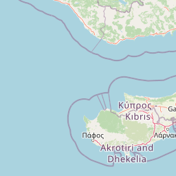
Map view of Potamos Paramaliou

Use this park location map to pinpoint Potamos Paramaliou in Cyprus, understand its exact geographic position, and read its mapped placement within the surrounding landscape more clearly.

Pigeon | © OpenStreetMap contributors
Recorded earthquake history

View the Historical Earthquake Catalogue for Potamos Paramaliou

Examine a collection of recorded seismic events associated with the surrounding landscape of Potamos Paramaliou. This MoriAtlas catalogue provides a clear, data-driven perspective on historical earthquake activity, offering essential insights for those studying the regional geography of this protected southwestern Cyprus river valley.

Potamos Paramaliou Earthquake History

Catalogued events

305 events

Strongest magnitude

Magnitude 5.6

Most recent event

Dec 12, 2025

This history includes earthquakes recorded inside the park or within 50 km of its borders

Park atlas

Compare regional protected landscapes, river valleys, and neighboring avian habitats.

Explore Other Parks Near Potamos Paramaliou and Surrounding Protected Areas

Browse nearby protected areas and related river valley sanctuaries following your visit to Potamos Paramaliou. Expanding your geographic comparison reveals broader ecological networks across southwestern Cyprus and Mediterranean natural terrain.
Protected areaCyprus
Mapped location lies within the park boundary#1 closest

Northeast

Metalleio Kalavasou: A Mediterranean Protected Area in Southern Cyprus

Mapped Mediterranean scrub, pine forests, and habitat mosaics.

Located in the foothills of the Limassol district, Metalleio Kalavasou represents a vital protected landscape within the European Natura 2000 network. The area serves as a case study for Mediterranean biodiversity, where dense pine canopies, olive woodlands, and open garrigue create a unique environment for numerous bird species, reptiles, and endemic vegetation types in a compact geographic footprint.

Area
0.471 km²
Established
1992
Climate
Mediterranean
Scope
Terrestrial
Protected areaCyprus
Mapped location lies within the park boundary#2 closest

Northeast

Periochi Kokkinokremmos: An Overview of the Protected Landscape and Regional Geography

A vital ecological sanctuary in the Mediterranean landscape of Cyprus.

Periochi Kokkinokremmos represents a specialized protected area in Cyprus, notable for its compact but high-density mosaic of Mediterranean ecosystems. From calcareous cliffs to pine-dominated woodlands, the site offers deep insight into the regional botanical and avian diversity supported by the island's unique Mediterranean terrain.

Area
1.002 km²
Established
1992
Relief
Mixed relief
Climate
Mediterranean
Nature reservePaphos District
5.8 km away#3 closest

West

Cha-Potami Nature Reserve: Protected Riverine Geography in Paphos District, Cyprus

River valley ecosystems and Mediterranean protected terrain

Cha-Potami spans a twelve-kilometer river stretch characterized by deep, narrow valleys and varied topography. This protected area offers a look into the rich ecological stratification of southwestern Cyprus, from dense riverside corridors and cypress-dotted slopes to rugged, raptor-nesting cliffside gorges that define the local landscape character.

Area
26.266 km²
Established
2000
Relief
Upland
Climate
Mediterranean
Nature reserveCyprus
7.5 km away#4 closest

Northeast

Koilada Limnati Nature Reserve: Geographic Atlas and Protected Landscape Overview

Mapping Mediterranean valley ecosystems in southern Cyprus

Koilada Limnati is a protected nature reserve in Cyprus, characterized by a diverse mosaic of Mediterranean valley habitats. The terrain features intermittent rivers, riverine galleries, and patches of endemic forest, serving as a critical refuge for dozens of bird species and regional wildlife. This atlas entry provides a detailed look at the site boundaries and its role within the Mediterranean ecoregion.

Area
4.389 km²
Established
2002
Climate
Mediterranean
Access
Access unknown
Nature reserveCyprus
8.1 km away#5 closest

Northwest

Koilada Diarizou Nature Reserve and Mediterranean River Valley Geography

Protected riparian landscapes in the Paphos district of Cyprus

Koilada Diarizou represents a prime example of a Mediterranean river valley protected area in western Cyprus. This nature reserve sustains a mosaic of rocky limestone slopes, cypress woodlands, and seasonal riparian channels that serve as a critical reference point for understanding the island's unique ecological connectivity.

Area
13.58 km²
Established
2002
Relief
Mixed relief
Climate
Mediterranean
Nature reserveCyprus
9.1 km away#6 closest

Southwest

Akrotirio Aspro - Petra Romiou Nature Reserve: Cyprus Coastal Geography and Habitat Map

Mediterranean coastal cliffs, bird habitats, and protected conservation landscapes

Akrotirio Aspro - Petra Romiou is an ecologically dense nature reserve in Cyprus, recognized for its varied Mediterranean terrain. The landscape transitions from iconic sea-stack formations and coastal cliffs into juniper matorral, pine forests, and riparian galleries. This site remains a crucial protected area for ornithological research and habitat connectivity across the southern Cypriot coastline.

Area
24.895 km²
Established
2004
Relief
Upland
Climate
Mediterranean
Protected areaCyprus
11 km away#7 closest

North

Dasos Pafou: Protected Forest Landscapes and Geographic Terrain of Western Cyprus

Extensive Mediterranean woodland and riparian habitat mosaic

Dasos Pafou serves as a cornerstone of conservation in western Cyprus, protecting a vast contiguous area of pine forests, oak woodlands, and rocky gorges. The site offers a detailed look at the island's diverse ecological character, blending high-altitude conifer stands with deep valley river systems to create a unique Mediterranean landscape atlas.

Area
602.259 km²
Established
2005
Relief
Mixed relief
Climate
Mediterranean
Protected areaCyprus
12 km away#8 closest

Northwest

Gkremoi Chanoutari Protected Area; Mapping Cyprus Inland Landscapes and Terrain

A critical Mediterranean bird sanctuary within the Troodos foothill region.

Gkremoi Chanoutari encompasses a unique mix of rocky crags, scrubby slopes, and rural hillsides across 2,470 hectares in the interior of Cyprus. This protected area serves as a primary site for cliff-nesting raptors and Mediterranean avifauna, offering a detailed look at the island's complex topography and mountain-to-valley ecological transitions.

Area
24.698 km²
Established
2007
Climate
Mediterranean
Scope
Terrestrial

Common questions about visiting, size, designation, and location context for Potamos Paramaliou

Potamos Paramaliou FAQs for park facts, access, geography, and protected area context

Find quick answers about Potamos Paramaliou, including protected-area facts, park geography, trail and visitor context, and how the park fits into its surrounding country and regional landscape.
MoriAtlas Explorer

Continue Your Protected Areas Search Across the Global Atlas

Deepen your exploration by continuing the structured search for national parks and protected areas worldwide. Utilize the comprehensive filtering capabilities to compare different conservation landscapes and refine your understanding of global park geography. Discover more about the distribution and characteristics of protected natural areas.

Global natural geography