
Mori Atlas logo
Nature reservePrameniště Chomutovky

Analyzing the ecological boundaries, glacial terrain, and hydrological features of this Krušné Hory protected site.

Prameniště Chomutovky Nature Reserve: Protected Peatland Landscapes and Ore Mountain Geography

(Přírodní rezervace Prameniště Chomutovky)

Prameniště Chomutovky represents a core protected area within the Krušné Hory of the Czech Republic, encompassing a complex of deep upland raised bogs and relict acidophilic forests. This mapping of the reserve reveals its significance as a habitat for bog-dependent species and its role in the broader regional hydrology. The terrain, defined by crystalline gneiss basement rocks and extensive peat deposits, supports a mosaic of spruce and mountain pine that reflects both ancient ecological history and ongoing restoration efforts.

peatlandraised bogOre MountainsKrušné horyblack grouse habitatNatura 2000
Digital illustration of a scenic mountain landscape featuring a waterfall cascading down a cliff face into a river, surrounded by pine forests and a foreground meadow with wildflowers and a dirt path.

Prameniště Chomutovky

Nature reserve

Park overview

Structured park overview, official facts, and landscape profile for Prameniště Chomutovky

Prameniště Chomutovky park facts, protected area profile, and essential visitor context

Review the core facts for Prameniště Chomutovky, including designation, size, terrain, visitor scale, habitats, and operating context in one park-focused overview.

About Prameniště Chomutovky

Prameniště Chomutovky occupies the upper reaches of the Chomutovka stream in the western Krušné hory, straddling the main road I/7 and reaching toward the German border. The reserve is divided into two main parts: a larger western block (Part A) covering the high plateau around Hora Svatého Šebestiána, and a smaller eastern block (Part B) that includes dissected terrain toward Načetín and the former Bučina na Kienhaidě woodland. Together they protect a representative slice of the northern Ore Mountains' peatland and forest mosaic.

At the heart of the protected area lies a chain of raised bogs including Pod Jelení horou, Pod Novoveským vrchem, Polské rašeliniště and the long-famous Schreiberovo rašeliniště. These bogs developed on ancient Proterozoic to Paleozoic gneisses of the Krušnohorské krystalnikum, where slow weathering, a cold climate and high precipitation allowed peat to accumulate to depths of more than 10 meters in places. The surrounding slopes carry remnants of acidophilic beech forest, waterlogged spruce stands, and small bog birch woodlands, while the valley floors hold mountain brook mires and old fishpond landscapes like Novoveský rybník.

The reserve sits in a cool, wet climatic zone with mean annual temperatures about 5.1°C, annual precipitation near 915 mm and a snow cover lasting between 100 and 120 days. This combination supports a community of boreal and sub-arctic relict species that are otherwise rare in the Czech Republic. Hydrology, however, has been shaped by centuries of intervention: historical peat cutting using the borkování method left countless small pools, many subsequent drainage ditches lowered the water table, and large areas were stripped of vegetation during intensive peat extraction in the 1970s.

Quick facts and research context for Prameniště Chomutovky

Prameniště Chomutovky is a Czech nature reserve (přírodní rezervace) established on 4 July 2012 by the Regional Authority of the Ústecký kraj. It lies in the Krušné hory (Ore Mountains), northwest of Hora Svatého Šebestiána in the Chomutov District, covering an area of about 18.8 square kilometers at elevations of 705 to 911 meters. It is classified under IUCN Category IV (habitat/species management area) and overlaps with the Novodomské a Polské rašeliniště Site of Community Importance and the Novodomské rašeliniště – Kovářská Special Protection Area. Its core purpose is the protection of mountain raised bogs with breeding black grouse.

Protection and recognition

Examining official designation records and management frameworks for Prameniště Chomutovky.

Prameniště Chomutovky Protection Status and Terrestrial Conservation Scope

Prameniště Chomutovky maintains a documented terrestrial protection scope within its designated natural boundary. Official records outline the established conservation status and management framework without additional international recognition sources.

Protection details

Protection scope
Terrestrial
Transboundary protection
No
Park context

Deeper park guide and search-rich context for Prameniště Chomutovky

Prameniště Chomutovky history, landscape, wildlife, and travel context

Explore Prameniště Chomutovky through its history, landscape character, ecosystems, wildlife, conservation priorities, cultural context, and seasonal travel timing in a structured park guide built for atlas discovery and search intent.

Why Prameniště Chomutovky stands out

The reserve is best known for its upland raised bogs hosting one of the core Czech populations of the black grouse (Tetrao tetrix), supported by the open mosaic of peatland, bog pine and relict spruce that the area still preserves. It is also notable for the depth of its peat deposits, including one of the deepest peat profiles in central Europe beneath the Novoveský vrch plateau, and for surviving fragments of acidophilic beech forest that once covered much more of the Ore Mountains.
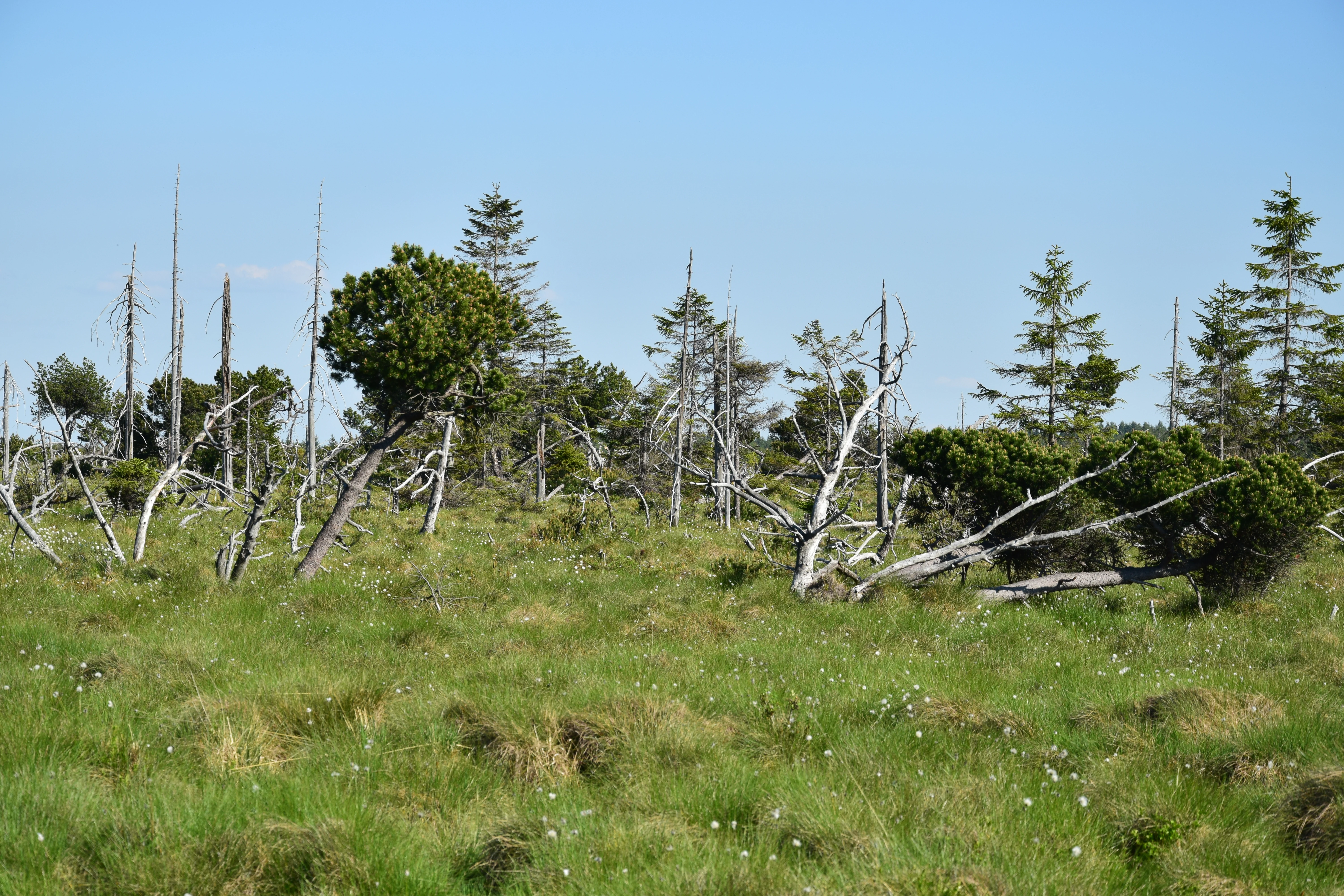
A wide view of a grassy peat bog with scattered spruce trees, some of which are dead and leafless, under a clear blue sky.
A view of the peat bog habitat on Skelny vrch within the Prameniště Chomutovky nature reserve.

Prameniště Chomutovky history and protected-area timeline

Human use of the peatlands around Prameniště Chomutovky reaches back to the first half of the 19th century, when peat was already being cut at Schreiberovo rašeliniště north of Hora Svatého Šebestiána. The traditional borkování technique produced numerous small open water bodies, while later drainage networks gradually silted these pools and lowered the water table. Industrial-scale extraction intensified during the 1970s, opening up large bare surfaces that have since been recovering only in the wettest places and along bog margins, where cotton grass (Eriophorum vaginatum) and scattered invertebrates have re-established themselves.

The legal framework for protection arrived only in 2012, when the Regional Authority of the Ústecký kraj declared the area a nature reserve on 4 July 2012, registering it in the Central List of Nature Conservation under code 5757. The declaration of this reserve coincided with the dissolution of the older Bučina na Kienhaidě reserve, whose territory was incorporated into the new protected area. Conservation priorities since declaration have included blocking the old drainage ditches and limiting further peat extraction to the disturbed Schreiberovo rašeliniště, with mandatory recultivation aimed at restoring natural hydrology.

A parallel social history runs through the landscape. The meadows around the former village of Jilmová, which was depopulated during the communist period, became an unexpected refuge for montane meadow species such as Meum athamanticum and Phyteuma nigrum. The mosaic of abandoned settlements, old roads and managed peatlands gives the present-day reserve both its ecological character and its layered cultural geography.

Prameniště Chomutovky landscape and geographic character

The landscape of Prameniště Chomutovky is dominated by the gently undulating plateau of the Krušné hory, where ancient crystalline basement rocks of gneiss have been coated in places by more than ten meters of peat. The broader geomorphological subunit is the Loučenská hornatina, with most of the reserve in the Přísečnická hornatina district and the smaller eastern section in the Rudolická hornatina. Elevation differences are modest but ecologically decisive, ranging from about 705 to 911 meters, and cold air drainage shapes both the vegetation and the persistence of snow late into spring.

Water is the defining sculptor of the terrain. Numerous small pools, peat cuttings, and former drainage ditches punctuate the bog surface, while ponds such as Novoveský rybník, Pohraniční rybník and Červený rybník mark the transitions between plateau and valley. The Chomutovka stream rises in the central part of Part A and flows eastward, while the Černá stream and Načetínský potok drain Part B southward toward the Flájský potok and eventually into the Freiberská Mulda and the Mulde river system on the German side.

In the south of the reserve the terrain steepens and the forests become more closed, with relict acidophilic beech stands on slopes like those around Čihadlo and Kienhaid. The road I/7 cuts across the plateau, separating the Polské rašeliniště from the rest of Part A and giving the reserve a clearly bipartite shape. The dynamic landscape of bare, regenerating, and fully vegetated bog is a direct expression of the long interaction between human extraction and the slow-building forces of peat accumulation.
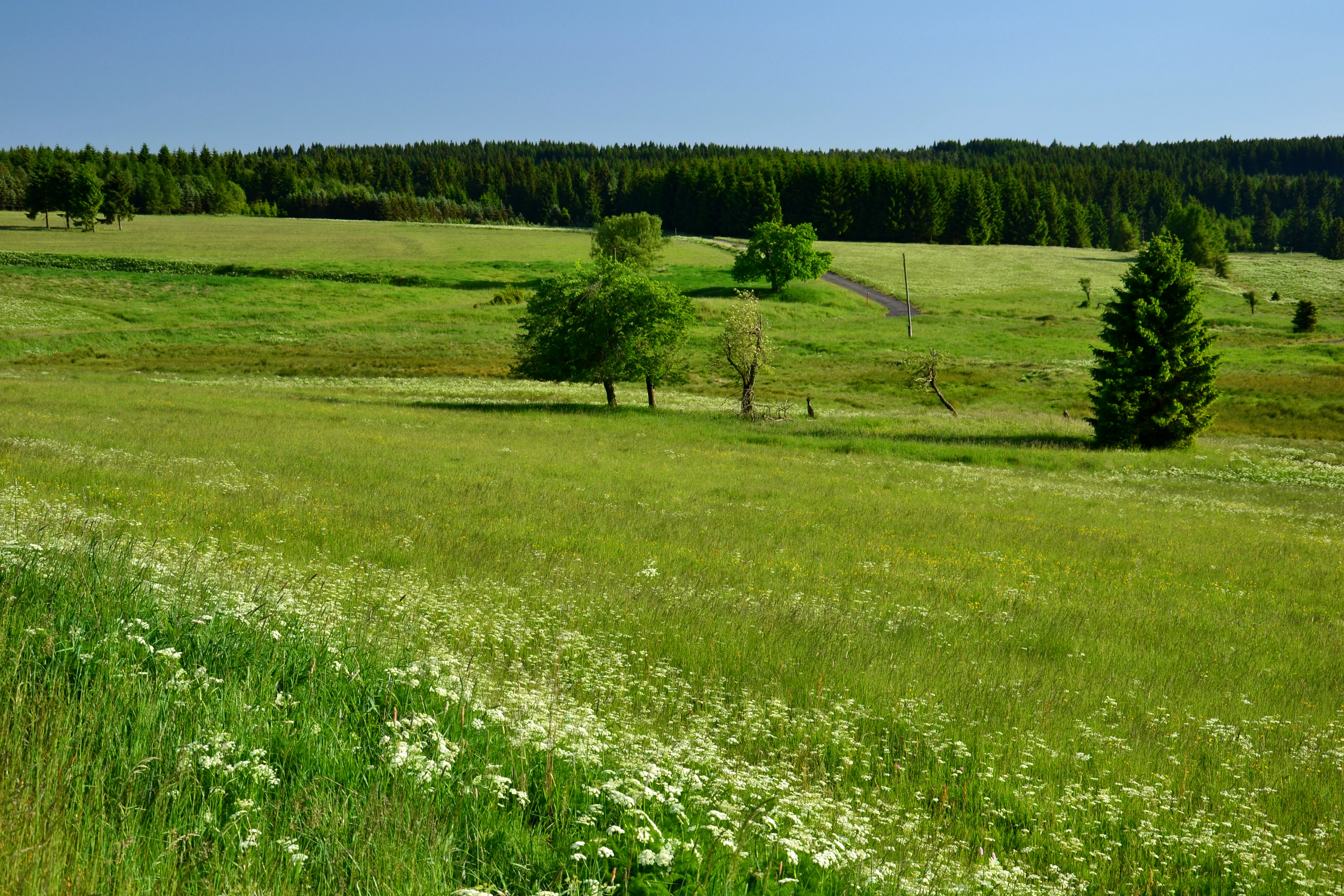
A wide, sunny landscape showing lush green grassy meadows with scattered trees and a distant forest edge under a clear blue sky.
Rolling meadows in the area surrounding Jilmova within the Prameniště Chomutovky nature reserve.

Prameniště Chomutovky ecosystems, habitats, and plant life

Ecologically, Prameniště Chomutovky is built around three principal vegetation complexes. The first, and most iconic, is a chain of upland raised bogs dominated by bog pine (Pinus mugo) and fringed by waterlogged spruce forests and small patches of bog birch woodland with Betula pubescens. These raised bogs include Pod Jelení horou, Pod Novoveským vrchem, Polské rašeliniště and Schreiberovo rašeliniště, the last of which retains much of its historical character of peat cuttings and regenerating vegetation.

The second complex consists of relict acidophilic beech forests on the steeper slopes, of which the former Bučina na Kienhaidě reserve is the most prominent surviving example. These beech woods are the westernmost substantial fragments of a forest type that once cloaked much more of the Ore Mountains and remain floristically important even where they are reduced to narrow strips and small patches. The third complex is montane meadow, surviving near the abandoned settlement of Jilmová and at Kienhaid, where traditional grassland species persist despite the lack of regular management.

The bog flora is exceptionally rich for central Europe. Characteristic and protected species include Andromeda polifolia, Empetrum nigrum, Vaccinium oxycoccos, Betula nana, Drosera rotundifolia and Ledum palustre, together with regionally rare sedges such as Carex limosa in the Polské rašeliniště. The meadows add an extra layer with threatened plants such as Meum athamanticum and Phyteuma nigrum. On shallower soils derived from gneiss weathering, podzols dominate, while the deeper peat sections create their own distinctive soils, hydrology and microclimate that favor the boreal relict character of the whole area.
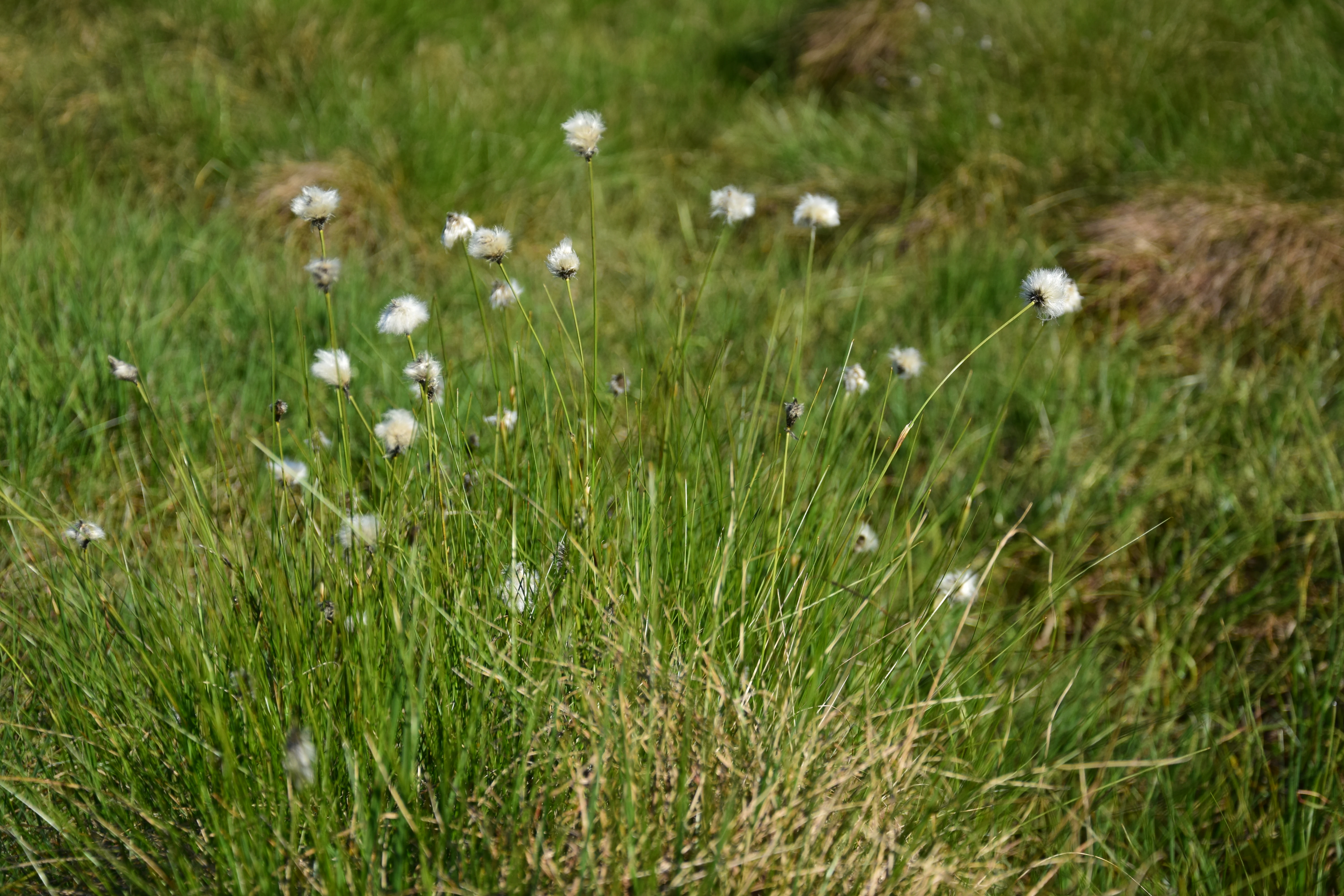
Clusters of white fluffy heads of tussock cottongrass blooming in a grassy peat bog meadow.
Tussock cottongrass in the peat bog environment of the Prameniště Chomutovky nature reserve.

Prameniště Chomutovky wildlife and species highlights

Prameniště Chomutovky is most renowned as the core of the Novodomské rašeliniště bird protection area, established primarily to safeguard the black grouse (Tetrao tetrix). Around 2012 the number of displaying males in the reserve was estimated at about 20 to 25 individuals. Their preferred habitat, an open mosaic of bog, bilberry-rich heath, scattered birch and bog pine, is exactly the landscape the reserve was set up to protect. Other notable bird species include about five pairs of grey-headed woodpeckers (Picus canus) nesting in the beech forest, and many red-listed species ranging from the red kite, black stork and whimbrel to the Eurasian curlew, hen harrier, honey buzzard and boreal owl, plus common cranes and the wetland specialists of the bog pools.

The reserve is also a stronghold for amphibians and reptiles. The alpine newt (Ichthyosaura alpestris), common newt (Lissotriton vulgaris), agile frog (Rana dalmatina) and common toad (Bufo bufo) reproduce in bog pools and ditches. Reptiles include the critically endangered common adder (Vipera berus), the slow worm (Anguis fragilis), the viviparous lizard (Zootoca vivipara) and the grass snake (Natrix natrix). High populations of red deer are an important ecological factor, shaping both the bog pine forests and the populations of dwarf birch and marsh Labrador tea in the area.

Invertebrate diversity matches the unusual habitat mosaic. The peatland specialist Colias palaeno, the bog dragonfly Somatochlora arctica, the rare spider Nuctenea silvicutrix and the moth Carsia sororiata (whose only other known Czech population lives in Šumava's Mrtvý luh) all occur here. The Polské rašeliniště also hosts rare spiders such as Araneus nordmani, several salticid species and the bright ground beetle Carabus nitens, alongside isolated records of the alpine Somatochlora alpestris and the beetle Oxythyrea funesta on warmer sites.
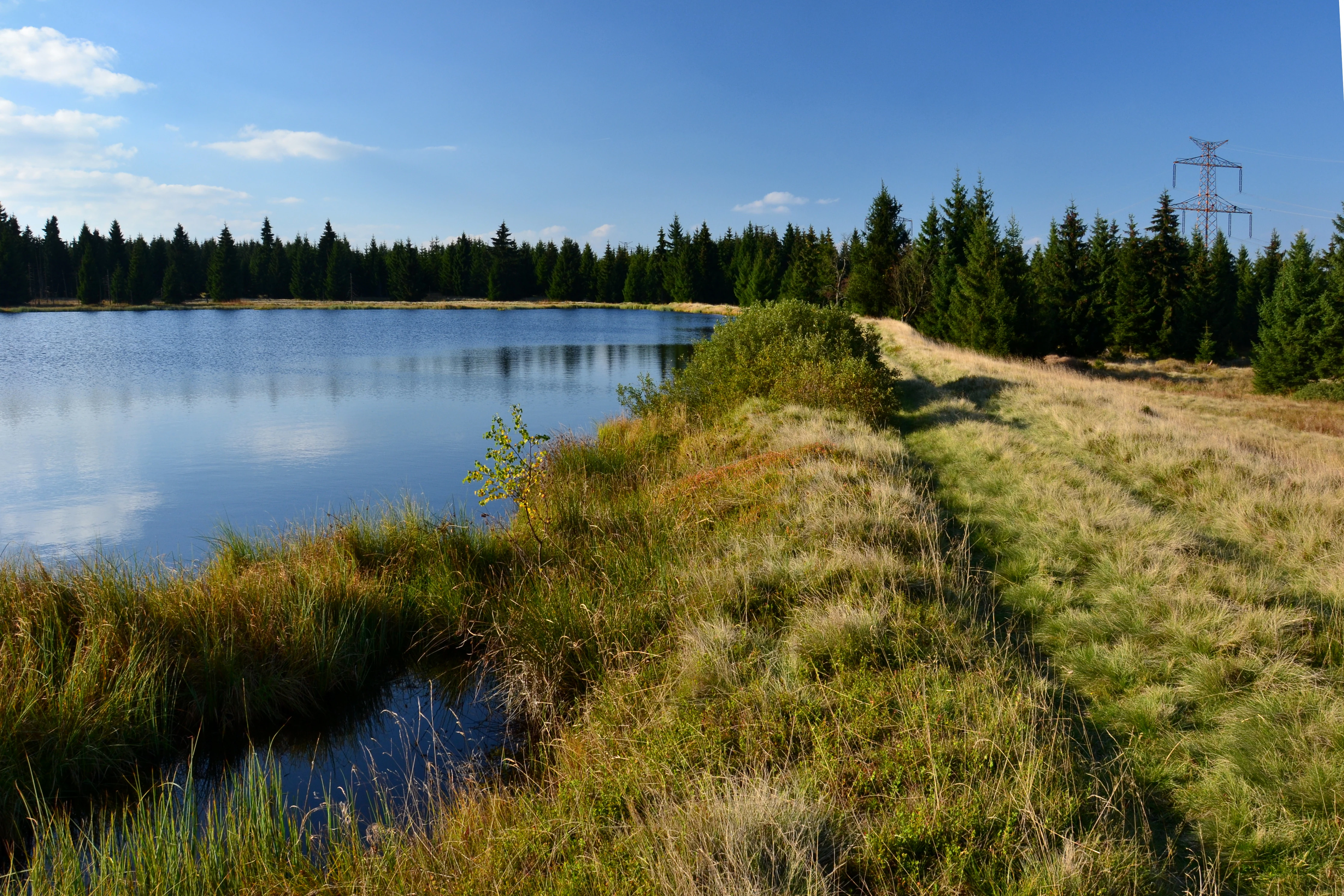
A still pond bordered by marshy grasses and a coniferous forest under a clear blue sky, with a power line tower visible in the background.
The Novoveský Pond within the Prameniště Chomutovky nature reserve.

Prameniště Chomutovky conservation status and protection priorities

Prameniště Chomutovky was established as a nature reserve specifically to consolidate protection of a peatland complex that is essential for the long-term survival of the black grouse in the central Ore Mountains. Its legal designation as a přírodní rezervace under Czech law, together with its inclusion in the EU Natura 2000 network as a Site of Community Importance and as a Special Protection Area, places it in the most stringent tier of Czech and European habitat protection. The IUCN Category IV assignment reflects its role as a managed habitat for a single vulnerable species.

The principal conservation task is the rewetting of the raised bogs. Historical peat extraction, drainage ditches and continuing intensive cutting, including after the reserve's declaration, have all lowered the water table and left large bare surfaces. A long-running management goal, set out explicitly at the time of declaration, is to abandon the existing melioration ditches so that the original bog hydrology can recover. Current plans still allow peat extraction in Schreiberovo rašeliniště, but only with compulsory recultivation aimed at restoring vegetation and water conditions.

The reserve's conservation importance also rests on the persistence of relict acidophilic beech forests and montane meadows in a landscape otherwise heavily altered by 20th-century industrial forestry and settlement clearance. Together with the larger Novodomské rašeliniště–Kovářská protected bird area, Prameniště Chomutovky forms a key node in maintaining the ecological connectivity of peatland and mountain forest habitats across the northern Krušné hory.

Prameniště Chomutovky cultural meaning and human context

The cultural geography of the reserve is shaped by the history of the Krušné hory borderland, where the population was reshaped dramatically in the second half of the 20th century after the displacement of the German-speaking inhabitants and the construction of the border zone. Settlements like Jilmová were depopulated, leaving behind meadows and forest fragments that now preserve species otherwise rare in the intensively farmed Czech countryside.

Traditional land use, including hay meadows, grazing and the systematic harvesting of peat through the borkování method, left a fine-grained imprint on the terrain. Many of the countless small pools that dot the peatlands today are relicts of this older, hand-extracted peat industry, which contrasts sharply with the large-scale industrial extraction of the 1970s. The juxtaposition of abandoned villages, drained bogs, planted spruce forests, and surviving relict habitats gives the area a layered cultural and historical character that goes beyond its strictly ecological value.

Top sights and standout views in Prameniště Chomutovky

Standout features of Prameniště Chomutovky include its chain of upland raised bogs with peat deposits among the deepest in central Europe, its role as the core of the Novodomské rašeliniště bird protection area for black grouse, and its surviving acidophilic beech forest fragments on slopes like Čihadlo and Kienhaid. The presence of rare bog specialists such as Carex limosa, Betula nana, Drosera rotundifolia and Colias palaeno, together with rare spiders, dragonflies and the bog-dependent moth Carsia sororiata, makes the reserve a significant reference site for understanding peatland biodiversity in the Ore Mountains and central Europe as a whole.

Best time to visit Prameniště Chomutovky

The most rewarding time to visit Prameniště Chomutovky is during the warmer months of late spring and summer, when snow has melted from the plateau and access along forest roads and the I/7 corridor becomes easier. Late spring is particularly fitting for seeing recovering bog vegetation and breeding amphibians around the ponds, while early summer shows the open peatland landscape at its most photogenic and offers the best chance of encountering displaying black grouse in the early morning.

The highland climate brings significant snow cover and cold temperatures for much of the year, and the long-lasting snowpack, fog and short daylight of the cold season make most of the reserve inaccessible on foot outside the late spring to early autumn window. As a peatland-dominated landscape, conditions can be wet and boggy even in summer, so visits are best planned for dry periods when wooden boardwalks and access routes are most usable.


Monthly climate preview

Long-term representative point measurements tracking monthly averages at 526 meters elevation

Prameniště Chomutovky Climate Normals: Annual Temperature and Precipitation Rhythm

Representative coordinate records show average monthly temperatures ranging from sub-zero winter minimums to warm summer highs alongside consistent daily precipitation. Exploring the complete twelve-month profile reveals detailed baseline patterns for this protected location.
Annual mean7 °C
-3 °C18 °C
Jan-3°
Feb-2°
Mar
Apr
May12°
Jun16°
Jul18°
Aug18°
Sep13°
Oct
Nov
Dec-2°
Warmest month
July

17.8 °C

Coolest month
January

-2.7 °C

Wettest month
July

2.7 mm/day

Driest month
April

1.4 mm/day

Park location guide

Geography guide, regional context, and park location map for Prameniště Chomutovky

Prameniště Chomutovky park geography, regions, and map view in Czechia

Understand where Prameniště Chomutovky sits in Czechia through a broader geographic reading of the surrounding landscape, nearby location context, and its mapped position within the national park landscape.

How Prameniště Chomutovky fits into Czechia

Czech Republic is a landlocked Central European country with a population of approximately 10.9 million people. The nation was established as an independent state on January 1, 1993, following the dissolution of Czechoslovakia. Its capital and largest city is Prague, with other major urban centers including Brno, Ostrava, Plzeň, and Liberec.

Wider geography shaping Prameniště Chomutovky in Czechia

The Czech Republic is a landlocked country in Central Europe. It is bordered by Germany to the west, Austria to the south, Poland to the northeast, and Slovakia to the southeast. The landscape is predominantly hilly, with the territory covering 78,871 square kilometers.

Map view of Prameniště Chomutovky

Use this park location map to pinpoint Prameniště Chomutovky in Czechia, understand its exact geographic position, and read its mapped placement within the surrounding landscape more clearly.

Pigeon | © OpenStreetMap contributors

Location context for Prameniště Chomutovky

Ústecký kraj

Visualizing the upland raised bogs and Ore Mountains terrain

Prameniště Chomutovky Photos and Landscape Scenery

Visual records capture the undulating peatland terrain, relict spruce forests, and high plateau scenery that define Prameniště Chomutovky. Examining field photography helps reveal the protected habitat structure and characteristic wetland ecosystems of the Ore Mountains.

A wide view of a grassy peat bog with scattered spruce trees, some of which are dead and leafless, under a clear blue sky.

A dirt trail winds through an autumn forest clearing with colorful orange and yellow foliage on trees and bushes.

A wide, sunny landscape showing lush green grassy meadows with scattered trees and a distant forest edge under a clear blue sky.

Clusters of white fluffy heads of tussock cottongrass blooming in a grassy peat bog meadow.

A still pond bordered by marshy grasses and a coniferous forest under a clear blue sky, with a power line tower visible in the background.

Park atlas

Compare adjacent highland reserves and connected peatland ecosystems across the regional terrain

Parks Near Prameniště Chomutovky and Surrounding Ore Mountains Protected Areas

Browsing other protected areas near Prameniště Chomutovky reveals the wider ecological context of the Krušné hory plateau. Comparing adjacent nature reserves helps trace regional forest patterns and highland bog formations across the mountain range.
A horizontal watercolor painting depicting a soft-focus landscape with rolling green meadows, distant hills, and patches of trees.
Natural monumentÚstecký kraj
About 3.5 km away#1 closest

South

Na loučkách II Natural Monument: Mapped Geography and Protected Upland Landscapes

Conservation areas in the Ore Mountains of the Ústecký kraj

Na loučkách II encompasses a substantial upland territory in the Czech Republic, characterized by a mix of peatland basins, heathland, and montane meadow mosaics. This natural monument serves as an essential ecological link within the Ore Mountains, protecting diverse highland terrain and supporting sensitive habitats in the Ústecký kraj administrative region.

Area
6.623 km²
Established
2013
IUCN
IV
Relief
Highland
Nature reserveSaxony
About 6.3 km away#2 closest

North

Steinbach Nature Reserve: Regional Geography and Protected Landscape Map

Ecological connectivity in the Saxon Ore Mountains

Steinbach Nature Reserve encompasses a significant mosaic of beech, spruce, and floodplain forest communities across the Saxon Ore Mountains. This protected area plays an essential role in the ecological network of the Preßnitz catchment, where it preserves rare species and traditionally managed highland meadows within a distinct mountain terrain.

Area
4.406 km²
Established
2008
IUCN
IV
Relief
Highland
Nature reserveÚstecký kraj
About 16 km away#3 closest

Southwest

Vápenka v Háji u Loučné pod Klínovcem: Nature Reserve and Calcareous Landscape Map

Examining rare flora and industrial heritage in Ústecký kraj.

Vápenka v Háji u Loučné pod Klínovcem protects an 8.37 hectare site defined by its unusual dolomitic geology and history of lime extraction. This landscape hosts a specialized assemblage of critically endangered fungi and plants, offering a distinct contrast to the acidic soils of the surrounding Ore Mountains.

Area
0.084 km²
Established
2024
IUCN
IV
Relief
Mountain
A watercolor painting showing a calm lake or pond surrounded by wetland vegetation, tall grasses, and distant rolling hills.
Nature reserveÚstecký kraj
About 16 km away#4 closest

Southeast

Pražská pole Nature Reserve: An Atlas of Wetland Recovery in Ústecký kraj

Protected wetland landscapes in the Czech Most Basin

Pražská pole is a remarkable nature reserve in the Ústecký kraj region, serving as a testament to natural recovery following deep brown coal mining. The site features a network of ten flooded subsidence depressions that host diverse aquatic communities, including specialized amphibians and dragonflies. This protected area offers significant value for understanding how industrial legacies transform into functional, high biodiversity wetland ecosystems within the Czech landscape.

Area
1.14 km²
Established
2024
IUCN
IV
Water
Major water bodies
A watercolor painting showing a rolling landscape with green hills, scattered trees, blossoming pink trees, and several large dark boulders in the foreground.
Natural monumentÚstecký kraj
About 18 km away#5 closest

South

Sluňáky Natural Monument: Geological Mapping and Protected Landscape Context

A preserved quartzite boulder field in the Ústecký kraj

Sluňáky represents a vital geological record within the Czech Republic, encompassing a distinctive group of silicified sandstone boulders. This natural monument serves as an important protected territory that illustrates the intersection of Tertiary geology and historical industrial extraction. The surrounding terrain reflects the complex volcanic and sedimentary history of the Doupovské hory foothills.

Area
0.032 km²
Established
1966
IUCN
III
Relief
Upland
Nature reserveSachsen
About 21 km away#6 closest

Southwest

Fichtelberg Nature Reserve: Mapped Protected Landscapes and Geography of the Saxon Erzgebirge

High-altitude mountain meadows, subalpine mires, and rare periglacial landforms.

Fichtelberg Nature Reserve protects a mosaic of high-altitude habitats across the Erzgebirge mountain range. This area features rare Nardus grasslands, spruce forests, and waterlogged mire systems. The landscape is defined by its complex ice-age legacy, containing notable frost-patterned ground structures that provide an essential window into the natural history of Saxony.

Area
2.09 km²
Established
2008
IUCN
IV
Nature reserveÚstecký kraj
About 21 km away#7 closest

South

Vinařský rybník Nature Reserve: Geographic Map and Protected Wetland Landscape

Lowland basin geography and habitat boundaries in Ústecký kraj.

Vinařský rybník represents a vital nature reserve and lowland wetland in the Ústecký kraj region, showcasing a distinct landscape of shallow ponds, reedbeds, and alluvial sediments. This site forms a key component of the regional avian habitat network, offering a concentrated look at the geological and hydrological features of the Žatecká pánev basin through detailed landscape mapping.

Area
0.151 km²
Established
1990
IUCN
IV
Relief
Upland
Natural monumentKarlovarský kraj
About 22 km away#8 closest

Southwest

Malý Stolec Natural Monument: Volcanic Landscape and Regional Protected Area Atlas

Exposing neovolcanic rock and ancient feeder conduits in Karlovarský kraj

Malý Stolec provides a focused view into the volcanic processes of the Doupovské hory. This natural monument displays rare geologic features including columnar jointing, coarse agglomeratic tuffs, and an intruded lava body. Its location on the southern slopes above the Ohře river offers a distinct landscape character that demonstrates how localized protected areas contribute to broader European conservation frameworks.

Area
0.06 km²
Established
2016
IUCN
IV
Relief
Mountain

Common questions about visiting, size, designation, and location context for Prameniště Chomutovky

Prameniště Chomutovky FAQs for park facts, access, geography, and protected area context

Find quick answers about Prameniště Chomutovky, including protected-area facts, park geography, trail and visitor context, and how the park fits into its surrounding country and regional landscape.
MoriAtlas Explorer

Continue Your Protected Areas Search Across the Global Atlas

Deepen your exploration by continuing the structured search for national parks and protected areas worldwide. Utilize the comprehensive filtering capabilities to compare different conservation landscapes and refine your understanding of global park geography. Discover more about the distribution and characteristics of protected natural areas.

Global natural geography