Mori Atlas logo
Wildlife reservePriest Wilderness

Analyzing the dramatic vertical relief and high elevation ridgeline of this Blue Ridge wilderness area.

Priest Wilderness: Mapping the Protected Appalachian Ridge and Forested Terrain in Nelson County

(Priest Wilderness Area)

Priest Wilderness preserves a rugged expanse of central Virginia terrain, characterized by the steep ascent of The Priest peak rising sharply above the Tye River valley. Covering over 5,700 acres, this protected landscape features mature hardwood forests and a prominent rocky spine that anchors the skyline. This resource provides a detailed look at the wilderness boundaries and its geographic context within the George Washington and Jefferson National Forests.

Blue RidgeAppalachian MountainsWilderness AreaHardwood ForestRidge HikingAppalachian Trail

Priest Wilderness

Wildlife reserve

Park overview

Structured park overview, official facts, and landscape profile for Priest Wilderness

Priest Wilderness park facts, protected area profile, and essential visitor context

Review the core facts for Priest Wilderness, including designation, size, terrain, visitor scale, habitats, and operating context in one park-focused overview.

About Priest Wilderness

Priest Wilderness sits in the heart of Virginia's Blue Ridge, a region where the Appalachians drop from broad, rounded highlands into deeply cut river valleys. Although small by western U.S. standards, the wilderness captures the full vertical rhythm of the southern Blue Ridge in a compact footprint, rising from low, moist river-bottom forests along the Tye River up through mid-elevation hardwood slopes and finally to exposed rocky ridges near the summit of The Priest.

The wilderness is fully embedded within the larger George Washington and Jefferson National Forests, and it functions as a quiet but ecologically important complement to the surrounding managed forest landscape. Its boundaries buffer stretches of mature forest, protect ridgeline habitat from fragmentation, and provide a refuge for species that rely on large, contiguous blocks of interior forest. For wildlife that cannot easily cross roads or developed land, the protected slopes around The Priest offer one of the few places in the region where habitat remains essentially unbroken.

For visitors, the wilderness is closely associated with the Appalachian Trail, which threads through its length and is the only major hiking route inside the boundaries. The Natural Bridge Appalachian Trail Club, working under the Appalachian Trail Conservancy, maintains the footpath and the Priest Shelter near the summit, keeping the area accessible to long-distance hikers while preserving its wilderness character. The combination of a nationally significant trail, a dramatic single-peak ascent, and well-maintained volunteer stewardship has made Priest Wilderness a small but memorable part of the Appalachian hiking experience in Virginia.

Quick facts and research context for Priest Wilderness

Priest Wilderness is a U.S. Wilderness Area located in Nelson County, Virginia, within the George Washington and Jefferson National Forests. Designated in 2000, it covers 5,726 acres of Blue Ridge terrain and ranges in elevation from about 1,000 feet along the Tye River to 4,063 feet at the summit of The Priest. The wilderness is classified as IUCN Category Ib and is administered through the Glenwood/Pedlar Ranger District.

Protection and recognition

Review documented conservation management scope and official designation records for Priest Wilderness.

Priest Wilderness Protection Status, Terrestrial Designation History, and International Recognition Facts

Priest Wilderness maintains a registered terrestrial protection status established in the year 2000. Verified designation records outline the management scope and administrative framework governing this protected landscape.

Protection details

Protection scope
Terrestrial
Designated year
2000
Transboundary protection
No
Park context

Deeper park guide and search-rich context for Priest Wilderness

Priest Wilderness history, landscape, wildlife, and travel context

Explore Priest Wilderness through its history, landscape character, ecosystems, wildlife, conservation priorities, cultural context, and seasonal travel timing in a structured park guide built for atlas discovery and search intent.

Why Priest Wilderness stands out

Priest Wilderness is best known for the steep forested climb up The Priest, one of the most iconic short but intense Appalachian Trail ascents in central Virginia. Long-distance hikers and section hikers prize the southbound approach from Virginia State Route 56 for the roughly 3,100-foot gain packed into about 4.3 miles, ending at a rocky summit that anchors the skyline above the Tye River valley. The wilderness is also recognized as a representative piece of high-elevation Blue Ridge forest protected under the U.S. Wilderness system. Together with the neighboring Three Ridges Wilderness, it preserves a continuous tract of remote, mature hardwood forest and ridge habitat that has become increasingly rare in the eastern United States.

Priest Wilderness history and protected-area timeline

Priest Wilderness was formally designated as a U.S. Wilderness Area in 2000, becoming part of a wave of congressionally recognized wilderness additions in Virginia's national forests during that era. Its designation reflected a longstanding recognition that the steep slopes and forested ridges around The Priest had high value as intact Appalachian habitat and as a scenic anchor along the Appalachian Trail.

Even before its formal wilderness status, the area functioned as a working part of the George Washington and Jefferson National Forests under the U.S. Forest Service, administered through the Glenwood/Pedlar Ranger District. The national forest context shaped its early history, balancing timber management, recreation, and watershed protection across the surrounding landscape.

Wilderness designation in 2000 elevated the area's protection, locking in a higher standard of preservation that limits road construction, logging, and mechanized use. The change helped ensure that the ridge forests around The Priest, already crossed by the Appalachian Trail, would remain a continuous block of wild habitat rather than a fragmented patchwork. Trails and shelters, including the Priest Shelter near the summit, have continued to be maintained by volunteers from the Natural Bridge Appalachian Trail Club in the decades since designation.

Priest Wilderness landscape and geographic character

The landscape of Priest Wilderness is defined by a sharp, single-mountain spine that rises quickly from the surrounding lowlands. The Tye River flows along the northern edge of the wilderness at roughly 1,000 feet in elevation, while the crest of The Priest climbs to 4,063 feet above sea level. That vertical gain of more than 3,000 feet over a short horizontal distance creates the steep, switchbacking slopes that give the wilderness its distinctive shape.

Ridges and hollows dominate the terrain, with the central crest of The Priest forming the backbone of the area. Below the summit, the slopes fall away in a series of forested benches and drainages that descend toward the river. The result is a classic southern Appalachian profile: long, angled slopes cradling small streams, converging on a narrow, rocky spine at the top.

The wilderness sits within the broader Blue Ridge landscape, just south of the neighboring Three Ridges Wilderness. Together, the two areas frame the Tye River valley with nearly continuous protected ridgeline, giving the surrounding region a wilder character than the modest size of either individual wilderness would suggest.

Priest Wilderness ecosystems, habitats, and plant life

Priest Wilderness is covered almost entirely by mature Appalachian hardwood forest, reflecting its position within the temperate, well-watered southern Blue Ridge. Oak and hickory communities dominate the mid and lower slopes, with mixed mesophytic stands filling cooler, moister draws and northern exposures. As elevation climbs toward the summit of The Priest, the forest becomes more open and stunted, giving way to thin-soiled rocky vegetation typical of high Appalachian summits.

Elevation gradients produce a compressed but distinct layering of forest types. Lowland benches along the Tye River support richer, more diverse plant communities, while mid-elevation slopes host the transitional oak-hickory woodlands that characterize much of the central Blue Ridge. Nearer the ridgetop, cooler temperatures and exposed conditions favor hardier species and a more open canopy structure.

The wilderness plays a meaningful role in protecting this continuous forest block. By keeping road-building, mechanized activity, and large-scale timber management out of the area, it helps maintain the interior forest conditions that are increasingly uncommon in the eastern United States and that anchor much of the region's broader ecological value.

Priest Wilderness wildlife and species highlights

The continuous forest cover and steep, lightly disturbed slopes of Priest Wilderness make it a productive habitat for typical southern Appalachian forest wildlife. Black bears, white-tailed deer, wild turkey, and a rich assemblage of smaller mammals such as chipmunks, foxes, and raccoons use the area as core habitat. The vertical relief and intact forest canopy also support a healthy population of breeding and migrant songbirds.

Ridge-top and high-elevation habitats near the summit of The Priest are particularly important for birdlife. These areas contribute to regional habitat networks for forest-interior songbirds and raptors that rely on large, quiet blocks of mature woodland. Neighboring wilderness areas and national forest land reinforce this value by providing buffer habitat on either side of the wilderness boundary.

Because the wilderness is small in absolute terms, its wildlife significance comes primarily from its connection to surrounding conserved lands rather than its size alone. The combined network of Priest Wilderness, Three Ridges Wilderness, and the broader George Washington and Jefferson National Forests allows species with larger home ranges to move through the landscape with fewer barriers than is typical for the densely developed eastern United States.

Priest Wilderness conservation status and protection priorities

Priest Wilderness holds an IUCN Category Ib designation, recognizing it as a wilderness area managed to preserve its natural conditions and ecological integrity. Its 2000 designation locked in protections that limit road-building, mechanized recreation, commercial logging, and other activities that have historically fragmented Appalachian forests elsewhere in the region.

The area's conservation value lies both in what it protects and in what it connects. It preserves a substantial block of mature hardwood forest around an ecologically important ridge, and it ties into a larger landscape of national forest and neighboring wilderness that helps maintain functioning habitat networks across the central Blue Ridge. This connectivity is increasingly important as climate stress, invasive species, and land-use change reshape forests throughout the eastern United States.

Within the George Washington and Jefferson National Forests, Priest Wilderness serves as a benchmark for what minimally disturbed southern Appalachian forest looks like. The data, observations, and stewardship experience gathered here help inform broader forest management practices on adjacent lands, giving the wilderness a conservation role that reaches beyond its own boundaries.

Priest Wilderness cultural meaning and human context

The Priest has long been a recognizable landmark in the central Virginia Blue Ridge, and the mountain's profile has shaped local oral and place-name traditions in Nelson County and the surrounding region. As with many prominent southern Appalachian summits, it carries a name rooted in early settler-era geography and has long served as a wayfinding reference in a landscape of deep valleys and parallel ridges.

With the coming of long-distance hiking culture in the twentieth century, the mountain took on a second cultural role as a signature feature along the Appalachian Trail. Volunteers from the Natural Bridge Appalachian Trail Club have maintained the trail and the Priest Shelter near the summit, embedding the mountain into the shared stewardship culture of the Appalachian Trail community. That volunteer tradition is one of the area's most enduring human connections, blending recreation, conservation, and local pride.

Top sights and standout views in Priest Wilderness

Priest Wilderness is small in acreage but disproportionately dramatic in profile, rising from the Tye River at roughly 1,000 feet to the rocky crest of The Priest at just over 4,000 feet within the span of a few miles. Its single most celebrated feature is the southbound Appalachian Trail climb from Virginia State Route 56, a steep but popular section hike that compresses more than 3,000 vertical feet into a short, switching ascent.

The wilderness also stands out for its role within a broader network of Blue Ridge protected lands. Set alongside Three Ridges Wilderness and enveloped by the George Washington and Jefferson National Forests, it helps anchor one of the more continuously wild stretches of the central Virginia Appalachians.

Best time to visit Priest Wilderness

Spring and fall are generally the most rewarding times to experience Priest Wilderness. Spring brings mild temperatures, blooming forest understory, and active birdlife; the cooler, wetter conditions make the steep climb up The Priest more forgiving than in the heat of summer. Fall offers some of the most striking Appalachian hardwood color anywhere in the Blue Ridge, with the steep slopes around The Priest lighting up in vivid reds, oranges, and yellows against the surrounding green valleys.

Summer visits are possible but can be hot and humid, particularly on the lower forested sections of the trail. Winter brings its own quieter character, with leafless forests opening up long views from the summit ridge, though cold snaps and icy sections near the top can make travel more demanding. Because the wilderness is almost entirely accessed via the Appalachian Trail, conditions on the mountain are best judged by broader Blue Ridge weather rather than local town forecasts.
Monthly climate preview

Track measured monthly weather averages, temperature ranges, and precipitation totals

Priest Wilderness Climate Normals, Long-Term Temperature and Precipitation Patterns

Representative coordinate records show average monthly temperatures spanning sub-zero minimums to high summer maximums alongside consistent daily precipitation. Reviewing twelve-month climatology profiles provides detailed baseline context for regional temperature fluctuations and seasonal moisture distribution.
Annual mean11 °C
-1 °C23 °C
Jan-1°
Feb
Mar
Apr11°
May16°
Jun20°
Jul23°
Aug22°
Sep18°
Oct12°
Nov
Dec
Warmest month
July

22.9 °C

Coolest month
January

-1.4 °C

Wettest month
June

3.5 mm/day

Driest month
October

2.5 mm/day

Park location guide

Geography guide, regional context, and park location map for Priest Wilderness

Priest Wilderness park geography, regions, and map view in United States of America

Understand where Priest Wilderness sits in United States of America through a broader geographic reading of the surrounding landscape, nearby location context, and its mapped position within the national park landscape.

How Priest Wilderness fits into United States of America

The United States of America is a federal presidential republic and one of the world's largest countries by area and population. It consists of 50 states across a vast territory spanning multiple time zones, with its capital in Washington, D.C. and largest city in New York City. The nation has a diverse economy, influential political system, and significant cultural and military presence globally.

Wider geography shaping Priest Wilderness in United States of America

The United States occupies a vast territory in North America, bordered by Canada to the north and Mexico to the south. The 48 contiguous states stretch from the Atlantic to the Pacific Ocean, while Alaska occupies the northwestern region and Hawaii is an archipelago in the Pacific. The country encompasses diverse terrain including the Rocky Mountains, Appalachian Mountains, Great Plains, and extensive river systems.

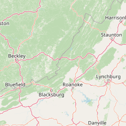
Map view of Priest Wilderness

Use this park location map to pinpoint Priest Wilderness in United States of America, understand its exact geographic position, and read its mapped placement within the surrounding landscape more clearly.

Pigeon | © OpenStreetMap contributors

Location context for Priest Wilderness

Nelson CountyVirginia
Park atlas

Compare adjacent mountain landscapes and connected regional wilderness corridors in central Virginia.

Exploring Other Parks Near Priest Wilderness and Surrounding Blue Ridge Protected Areas

Compare adjacent mountain parks and connected protected landscapes across the surrounding Blue Ridge region. Examining nearby wilderness areas provides broader geographic context for the steep Appalachian terrain surrounding Priest Wilderness.
Watercolor painting of rolling hills, trees, and a river in a scenic landscape
National parkVirginia
25 km away#1 closest

Northeast

Shenandoah National Park: National Park Protected Landscape and Geography

Mapped terrain and protected area context in Virginia.

Shenandoah National Park is a designated national park in Virginia, offering a rich exploration of its protected landscape and geographic features. This page provides detailed atlas-oriented information, focusing on the park's mapped boundaries and its role within the regional geography. Discover the natural terrain and spatial identity of this important US protected area, ideal for understanding park landscapes.

Area
811.176 km²
Established
1935
IUCN
II
Visitors
1.7M annual
A wide watercolor illustration showing rolling mountains in pastel shades of pink, purple, and green, with a line of trees and a reflective body of water in the foreground, framed by bare tree branches on the sides.
Protected areaVirginia
33 km away#2 closest

Southwest

James River Face Wilderness: Mapping the Topography of Virginia's Blue Ridge Protected Landscapes

Geographic overview of mountain wildlands and boulder fields

Spanning over 8,900 acres, James River Face Wilderness serves as a vital protected area within the Appalachian mountain chain. The landscape contains steep creek drainages, vertical ridgelines, and significant geological formations such as the Devils Marbleyard, offering a comprehensive study of central Virginia's complex forest ecosystems and rugged mountain terrain.

Area
36.05 km²
Established
1975
IUCN
Ib
Relief
Mountain
Wildlife reserveVirginia
45 km away#3 closest

West

Rich Hole Wilderness: Appalachian Wildlife Reserve and Forest Geography

Protected cove hardwood forest in western Virginia

Rich Hole Wilderness represents a protected high quality forest landscape located within the James River Ranger District. This area spans steep, narrow hollows and high ridge crests, providing critical habitat and showcasing old growth timber specimens. Use this resource to understand the park terrain, drainage patterns, and its position within the broader Appalachian forest network of western Virginia.

Area
26.1 km²
Established
1988
IUCN
Ib
Relief
Mountain
Wildlife reserveVirginia
51 km away#4 closest

West

Rough Mountain Wilderness: Mapping Appalachian Ridges and Protected Terrain

Remote wildlife reserve in western Virginia

Spanning over 9,000 acres, Rough Mountain Wilderness provides a rare example of undisturbed Appalachian forest. The area is characterized by consistently steep slopes, sharp ridgeline topography, and a deep sense of isolation within the George Washington and Jefferson National Forests of western Virginia.

Area
38 km²
Established
1987
IUCN
Ib
Relief
Mountain
A soft watercolor illustration depicting a stream flowing through a forested valley with mountain ridgelines in the background.
Wildlife reserveUnited States of America
About 58 km away#5 closest

Northwest

Ramseys Draft Wilderness: Appalachian Ridge and Valley Protected Landscape and Map Atlas

Examining wilderness boundaries and mountain stream geography in Virginia

Located in western Virginia, Ramseys Draft Wilderness is a federal protected area characterized by its extreme vertical relief and rugged Appalachian topography. Spanning from the main crest of Shenandoah Mountain to the valley floor, this wilderness serves as a vital corridor for high-elevation forest ecosystems, native brook trout, and neotropical migrant birds.

Area
26.38 km²
Established
1984
Relief
Mountain
Climate
Temperate
Watercolor illustration depicting a serene mountain landscape with a winding river, rolling hills, and scattered trees against a light background.
Protected landscapeVirginia
About 72 km away#6 closest

North

George Washington and Jefferson National Forests: Appalachian Protected Landscape Mapping

Explore mountain ridges, river valleys, and wilderness corridors in Virginia.

Covering one of the largest public forest blocks in the eastern United States, George Washington and Jefferson National Forests offer a unique look at the central Appalachian mountain terrain. The area includes extensive wilderness tracts, the Appalachian Trail corridor, and significant geological landmarks like the Breaks gorge. Analyze the protected landscape boundaries and topographic features that define this major regional watershed and forest network.

Area
7,247.65 km²
Established
1995
Relief
Mountain
Climate
Temperate
Watercolor painting showing layers of soft green hills and mountain ridges fading into a light hazy background.
Protected landscapeWest Virginia
78 km away#7 closest

Northwest

Monongahela National Forest: Protected Appalachian Landscapes and Regional Geography

Mapping West Virginia wilderness and mountain terrain

Monongahela National Forest protects nearly one million acres of the central Appalachian Mountains. This massive federally managed landscape is defined by the Allegheny Front, the highest peak in the Allegheny range at Spruce Knob, and iconic geological formations like Seneca Rocks. The region represents a vital intersection of climate, hydrology, and biodiversity in the eastern United States, housing eight distinct wilderness areas and complex high-altitude ecosystems.

Area
3,727.8 km²
Established
1920
Visitors
3M annual
Relief
Mountain
A wide, panoramic watercolor illustration showing a row of green trees, faint mountains in the background, and grass reeds in the foreground left against a white background.
Wildlife reserveWest Virginia
106 km away#8 closest

Northwest

Laurel Fork South Wilderness: Protected Appalachian Highlands and Forested Terrain

High elevation forest and creek drainage geography

Laurel Fork South Wilderness features a dense, unbroken stretch of Appalachian forest within West Virginia. This protected landscape is defined by its deep narrow hollows and high ridgelines, representing a vital example of mid elevation mountain terrain and recovering forest ecosystems within the Monongahela National Forest.

Area
23.41 km²
Established
1983
IUCN
Ib
Relief
Mountain

Common questions about visiting, size, designation, and location context for Priest Wilderness

Priest Wilderness FAQs for park facts, access, geography, and protected area context

Find quick answers about Priest Wilderness, including protected-area facts, park geography, trail and visitor context, and how the park fits into its surrounding country and regional landscape.
MoriAtlas Explorer

Continue Your Protected Areas Search Across the Global Atlas

Deepen your exploration by continuing the structured search for national parks and protected areas worldwide. Utilize the comprehensive filtering capabilities to compare different conservation landscapes and refine your understanding of global park geography. Discover more about the distribution and characteristics of protected natural areas.

Global natural geography