Mori Atlas logo
Wildlife reservePrince Edward Point National Wildlife Area

Mapping the migratory flyway and shoreline terrain of this significant wildlife reserve

Prince Edward Point National Wildlife Area: A Protected Landscape in Ontario Canada

Prince Edward Point National Wildlife Area occupies a prominent peninsula on the southeastern edge of Ontario, extending directly into the waters of Lake Ontario. This protected landscape serves as a vital concentration point for migratory songbirds and raptors, funneling avian populations through a mix of coastal cliffs, cobble beaches, and mixed woodland habitats. Its position on the Great Lakes flyway supports long-running conservation monitoring and research within a compact, ecologically dense regional geography.

national wildlife areabird observatorybirdwatchingmigratory birdsLake Ontario shorelinePrince Edward County

Prince Edward Point National Wildlife Area

Wildlife reserve

Park overview

Structured park overview, official facts, and landscape profile for Prince Edward Point National Wildlife Area

Prince Edward Point National Wildlife Area park facts, protected area profile, and essential visitor context

Review the core facts for Prince Edward Point National Wildlife Area, including designation, size, terrain, visitor scale, habitats, and operating context in one park-focused overview.

About Prince Edward Point National Wildlife Area

Prince Edward Point National Wildlife Area protects a small but ecologically significant landscape at the southeastern tip of Prince Edward County, Ontario. The area lies where the land narrows into a peninsula reaching out into Lake Ontario, a position that gives the site an outsized importance for wildlife, especially birds moving along the lake's northern shoreline.

The reserve is part of Canada's network of National Wildlife Areas and is managed by the Canadian Wildlife Service to protect habitat used by migratory birds and a wide range of other wildlife. The area includes forest, thicket, shoreline, and edge habitats that together create the kind of structural diversity migrating birds rely on for feeding and resting during their long journeys. Because much of the surrounding landscape in Prince Edward County remains relatively rural and forested, the protected area functions as a key refuge within a broader working landscape.

Beyond its formal designation, the wildlife area is closely tied to the Prince Edward Point Bird Observatory, which has run long term migration monitoring, bird banding, and community science programs from the site. This combination of formal federal protection and active ornithological research gives the area both conservation value and a strong profile within the North American birding community.

Quick facts and research context for Prince Edward Point National Wildlife Area

Prince Edward Point National Wildlife Area is a federally protected wildlife area in Prince Edward County, Ontario, Canada, established in 1980 and covering approximately 5.6 square kilometers of land and nearshore habitat. It is administered by the Canadian Wildlife Service as one of Canada's National Wildlife Areas and is classified as a strict nature reserve under IUCN Category Ia.

Since 1960 the surrounding region has been recognized as an Important Bird Area, and the site is home to the Prince Edward Point Bird Observatory, a well known migration monitoring station. More than 300 bird species have been recorded here, including songbirds, waterfowl, owls, and hawks, and the area supports 33 species listed under Canada's federal Species at Risk Act.

Protection and recognition

Examine documented terrestrial protection metrics and official conservation scope records.

Prince Edward Point National Wildlife Area Protection Status and Formal Designation Data

Prince Edward Point National Wildlife Area holds recorded terrestrial protection status within global databases. Systematic records outline the established conservation scope and associated registry details for this protected area.

Protection details

Protection scope
Terrestrial
WDPA ID
18182
Park context

Deeper park guide and search-rich context for Prince Edward Point National Wildlife Area

Prince Edward Point National Wildlife Area history, landscape, wildlife, and travel context

Explore Prince Edward Point National Wildlife Area through its history, landscape character, ecosystems, wildlife, conservation priorities, cultural context, and seasonal travel timing in a structured park guide built for atlas discovery and search intent.

Why Prince Edward Point National Wildlife Area stands out

Prince Edward Point National Wildlife Area is most famous for its role as a major spring and fall migration concentration point for birds traveling along the Lake Ontario shoreline. The combination of a prominent peninsula jutting into the lake and adjacent forest cover creates excellent conditions for observing warblers, other songbirds, and a steady passage of raptors during migration. The area is also known for its long running ornithological research and monitoring program run from the Prince Edward Point Bird Observatory, one of the better known bird observatories in eastern Canada. Its unusually high species count for a small protected area and its importance for species at risk make it stand out among Canadian wildlife reserves.

A single-story, light-colored building with a metallic roof and dark window frames situated in a grassy clearing with trees.
The Prince Edward Point Bird Observatory station building, which serves as a base for migratory bird research.

Prince Edward Point National Wildlife Area history and protected-area timeline

The site now known as Prince Edward Point National Wildlife Area began to attract scientific attention well before its formal protection. As early as 1960, the area was recognized as an Important Bird Area for migratory birds, particularly songbirds and several raptor species passing along the Lake Ontario shoreline.

Building on that recognition, the area was formally designated as a National Wildlife Area in 1980, placing it under the responsibility of the Canadian Wildlife Service, part of Environment and Climate Change Canada. The designation aimed to secure the habitat that supported the area's exceptional migratory bird diversity and its importance for species at risk.

The Prince Edward Point Bird Observatory has grown alongside the reserve as a central institution at the site. Its banding, monitoring, and research activities have helped establish the area's reputation in Canadian ornithology and have contributed to broader understanding of migration along the lower Great Lakes.

Prince Edward Point National Wildlife Area landscape and geographic character

The wildlife area occupies the southeastern tip of Prince Edward County, a long, narrow peninsula extending into the northeastern end of Lake Ontario. The terrain combines gently rolling rural land with areas of forest, shoreline cliff and cobble, and shallow nearshore waters along Lake Ontario.

From the point itself there are open lake views across Lake Ontario toward the New York shore, while inland the landscape shifts into mixed woodland, hedgerows, and pockets of meadow typical of the county. This mix of lakefront exposure and vegetated interior creates the landscape structure that influences how migrating birds move through the area and where they concentrate during peak migration periods.

Prince Edward Point National Wildlife Area ecosystems, habitats, and plant life

The protected area preserves a mosaic of habitats at the meeting point of Lake Ontario and the rural countryside of Prince Edward County. Mature mixed forest, early successional thicket, shrubby edge, and shoreline habitats all occur within or near the reserve, offering a range of cover and food resources for wildlife.

The diversity of habitat types in such a compact area helps explain the site’s unusually high species counts. Forest interior species, edge specialists, and shoreline associated birds can all be found in close proximity, and the same structural variety supports a wide range of insects and other organisms that migratory birds depend on during stopover periods.

Prince Edward Point National Wildlife Area wildlife and species highlights

Birdlife is the dominant feature of Prince Edward Point National Wildlife Area. More than 300 bird species have been recorded in the area, an extraordinary total for a site of its size. This includes large numbers of warblers and other songbirds, waterfowl, owls, falcons, and other raptors, all of which pass through during spring and fall migration.

The area is especially important for species at risk. Thirty three species listed under Canada's federal Species at Risk Act have been documented here, underlining how much of the broader regional biodiversity depends on the habitats the reserve protects. The combination of active bird banding, public monitoring, and long term data collection has made the site a reference location for migration studies in eastern Canada.

While birds dominate the wildlife profile, the area also supports broader biodiversity typical of southern Ontario’s mixed forest and shoreline environments, including small mammals, reptiles, amphibians, and pollinators associated with its varied habitats.

Prince Edward Point National Wildlife Area conservation status and protection priorities

Prince Edward Point National Wildlife Area plays a focused but important role in Canadian conservation. As a National Wildlife Area managed by the Canadian Wildlife Service, it is part of a national network of sites designed to protect habitat for migratory birds and other wildlife of national significance. Its IUCN Category Ia designation reflects a strict nature reserve approach prioritizing ecological values over other uses.

The reserve’s conservation significance is heightened by the number of species at risk recorded here. Thirty three species listed under the federal Species at Risk Act have been documented, suggesting that the mix of protected forest, shoreline, and surrounding rural landscape is providing critical habitat that is increasingly rare elsewhere in the region.

Long term monitoring through the Prince Edward Point Bird Observatory adds a research dimension to the reserve’s conservation role, contributing migration data, banding records, and population insights that inform broader conservation planning along the Lake Ontario flyway.

Prince Edward Point National Wildlife Area cultural meaning and human context

The site sits within Prince Edward County, a region of Ontario known for its rural character, agricultural heritage, and longstanding connection to Lake Ontario. The point itself has historically been a working landscape where fishing, farming, and small scale coastal activity shaped the local community.

Birding and natural history have become a recognized part of the regional identity in recent decades, with the observatory attracting visitors, volunteers, and researchers who contribute to the local economy and community life. This blend of rural tradition and modern conservation science gives the area a distinctive cultural backdrop.

Top sights and standout views in Prince Edward Point National Wildlife Area

Prince Edward Point National Wildlife Area stands out for the sheer density of bird diversity packed into a small area at the tip of Prince Edward County. Its position on a migratory flyway, combined with varied forest and shoreline habitat, produces one of the most rewarding birdwatching experiences in southern Ontario, especially during spring and fall migration.

The presence of a long established bird observatory, federal National Wildlife Area status, and a documented list of more than 300 species, including 33 species at risk, give the site a layered identity as both a conservation stronghold and a working field station for migration science.

Best time to visit Prince Edward Point National Wildlife Area

The most rewarding times to experience Prince Edward Point National Wildlife Area are during the spring and fall bird migrations, when songbirds, raptors, and waterfowl concentrate along the Lake Ontario shoreline. Spring brings waves of warblers and other returning migrants, while fall produces a sustained passage of songbirds and a strong raptor flight.

Summer visits are quieter for migration but still offer forest, shoreline, and breeding bird activity, while winter brings a different character with waterfowl on open water and possible sightings of owls and northern species. In every season the compact landscape and mix of habitats make the area productive for wildlife observation.

Monthly climate preview

Long-term representative temperature and precipitation averages recorded across twelve monthly intervals

Prince Edward Point National Wildlife Area Climate Normals and Annual Weather Rhythm

Representative coordinate measurements track the annual temperature swing and daily precipitation rhythm across twelve recorded months at Prince Edward Point National Wildlife Area. Examining the complete monthly climate normals reveals full baseline distributions for long-term temperature ranges and precipitation patterns.
Annual mean8 °C
-4 °C21 °C
Jan-4°
Feb-4°
Mar
Apr
May11°
Jun17°
Jul21°
Aug21°
Sep18°
Oct11°
Nov
Dec
Warmest month
August

21.3 °C

Coolest month
January

-4.4 °C

Wettest month
October

2.7 mm/day

Driest month
March

1.7 mm/day

Park location guide

Geography guide, regional context, and park location map for Prince Edward Point National Wildlife Area

Prince Edward Point National Wildlife Area park geography, regions, and map view in Canada

Understand where Prince Edward Point National Wildlife Area sits in Canada through a broader geographic reading of the surrounding landscape, nearby location context, and its mapped position within the national park landscape.

How Prince Edward Point National Wildlife Area fits into Canada

Canada is a federal parliamentary constitutional monarchy spanning North America from the Atlantic to the Pacific and Arctic Oceans. With a population of over 41 million, it is officially bilingual in English and French at the federal level. The country gained independence from the United Kingdom through a gradual process culminating in 1982.

Wider geography shaping Prince Edward Point National Wildlife Area in Canada

Canada occupies the northern portion of North America, sharing its longest international border with the United States. The country extends from the Atlantic Ocean to the Pacific Ocean and northward into the Arctic Ocean, giving it the longest coastline of any nation.

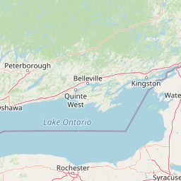
Map view of Prince Edward Point National Wildlife Area

Use this park location map to pinpoint Prince Edward Point National Wildlife Area in Canada, understand its exact geographic position, and read its mapped placement within the surrounding landscape more clearly.

Pigeon | © OpenStreetMap contributors

Location context for Prince Edward Point National Wildlife Area

Ontario

Visualizing the shoreline terrain, mixed woodlands, and protected habitats

Prince Edward Point National Wildlife Area Photos and Scenery

Explore detailed Prince Edward Point National Wildlife Area photos showcasing the unique shoreline cliffs, mixed woodlands, and open waters of the Lake Ontario peninsula. Reviewing these protected landscape views provides essential visual context for understanding local habitats and migratory bird environments.

A single-story, light-colored building with a metallic roof and dark window frames situated in a grassy clearing with trees.

Park atlas

Compare surrounding protected landscapes and wildlife habitats along the Lake Ontario shoreline

Explore Parks Near Prince Edward Point National Wildlife Area and Regional Reserves

Browse other parks near Prince Edward Point National Wildlife Area to examine adjacent shoreline habitats and regional conservation lands. Evaluating connected protected areas expands regional geographical comparison and provides broader context on local migratory bird corridors.
Watercolor painting of green hills, islands, and a body of water under a pale yellow sky
National parkOntario
About 18 km away#1 closest

Northeast

Thousand Islands National Park: Exploring Ontario's Protected Landscape Geography

Discover the mapped terrain and regional context of this national park.

Uncover the protected landscape identity of Thousand Islands National Park, a key national park located in Ontario. This resource focuses on its geographic setting, mapped boundaries, and overall atlas context, providing a clear understanding of its role as a protected area. Explore how its unique terrain contributes to the regional geography and the broader national park network, offering valuable insight for landscape-focused discovery.

Area
24.4 km²
Established
1904
IUCN
II
Visitors
109.3K annual
Marine protected areaNew York
About 47 km away#2 closest

South

Lake Ontario National Marine Sanctuary: Geographic Atlas and Protected Area Overview

Mapping freshwater maritime heritage and coastal New York landscapes.

Spanning the southeastern waters of Lake Ontario, this marine protected area safeguards dozens of historic shipwrecks and vital Indigenous cultural sites. This atlas entry provides geographic context on the sanctuary boundaries, submerged archaeological zones, and the surrounding New York freshwater environment.

Area
4,460 km²
Established
2024
IUCN
V
Relief
Lowland
Wildlife reserveOntario
About 59 km away#3 closest

West

Wellers Bay National Wildlife Area: Coastal and Island Geography in Ontario

An important Great Lakes barrier beach protected reserve

Wellers Bay National Wildlife Area contains a rare collection of undeveloped shorelines, including the Baldhead peninsula and offshore islands. This protected area offers a deep look into the littoral processes of Lake Ontario, providing crucial sanctuary for waterbirds and endangered species within a fragile, compact, and natural woodland environment.

Area
0.74 km²
Established
1978
IUCN
Ia
Scope
Terrestrial
Wildlife reserveOntario
About 132 km away#4 closest

North

Zugvogelschutzgebiet Mississippi Lake Protected Landscape and Wildlife Reserve Atlas

Waterfowl habitat and wetland geography in Ontario

Zugvogelschutzgebiet Mississippi Lake serves as a designated wildlife reserve providing essential staging grounds for migratory waterfowl. Located at the river-mouth interface on Mississippi Lake, the area encompasses provincially significant wetlands within Ewan Bay. This protected footprint offers a distinct look at the quiet, low-relief hydrology and marsh ecology characteristic of the broader southern Ontario basin.

Area
2.84 km²
Established
1959
IUCN
IV
Relief
Lowland
Wildlife reserveOntario
About 134 km away#5 closest

Northeast

Rideau Migratory Bird Sanctuary: Protected Wildlife Reserve and Regional Waterfowl Habitat

Riparian conservation zones along the Rideau River in Ontario

The Rideau Migratory Bird Sanctuary protects a strategically important riparian corridor within Ontario. This federal wildlife reserve provides essential refuge for migratory birds along the Rideau River system, offering a specialized look at the region's diverse wetland margins and floodplain geography.

Area
7.52 km²
Established
1957
National parkOntario
About 181 km away#6 closest

West

Rouge National Urban Park: Ontario's Mapped Protected Landscape Atlas

Explore national park boundaries and regional geography.

Investigate Rouge National Urban Park, a designated national park situated in Ontario, Canada. This page provides detailed atlas-style information focusing on its mapped boundaries, regional geographic context, and its identity as a significant protected natural landscape. Understand the park's role within the broader Canadian atlas for landscape exploration.

Area
79.1 km²
Established
2015
IUCN
V
Relief
Mixed relief
A soft watercolor painting depicting a wide, marshy wetland scene with gentle green hills in the distance and reflections on the water surface.
Wildlife reserveQuebec
About 224 km away#7 closest

Northeast

Réserve nationale de faune du lac-Saint-François: A Protected Wetland Landscape in Quebec

Explore wildlife reserve boundaries, riparian habitats, and St. Lawrence River geography.

This protected area safeguards a diverse freshwater wetland complex along the St. Lawrence River. Covering marshes, cedar stands, and mixed hardwood forests, the reserve provides a critical sanctuary for migratory species. The geography of the site offers a unique look at transition zones between open water and inland plains, serving as a key node for bird conservation in Quebec.

Area
15.21 km²
Established
1978
IUCN
III
Relief
Lowland
Wildlife reserveOntario
About 232 km away#8 closest

Northwest

Eleanor Island Wildlife Reserve: Protected Ontario Lake Landscape and Bird Habitat

A federal migratory bird sanctuary in the Canadian Shield

Eleanor Island is a strictly protected migratory bird sanctuary in Ontario that serves as a vital nesting ground for colonial waterbirds. Positioned within Lake Muskoka, this small but ecologically purposeful nature reserve demonstrates the importance of localized federal protection for regional breeding populations. Its status as a strict nature reserve underscores a commitment to safeguarding sensitive habitats within the broader Canadian Shield wilderness.

Area
0.006 km²
Established
1978
IUCN
Ia
Relief
Lowland

Common questions about visiting, size, designation, and location context for Prince Edward Point National Wildlife Area

Prince Edward Point National Wildlife Area FAQs for park facts, access, geography, and protected area context

Find quick answers about Prince Edward Point National Wildlife Area, including protected-area facts, park geography, trail and visitor context, and how the park fits into its surrounding country and regional landscape.
MoriAtlas Explorer

Continue Your Protected Areas Search Across the Global Atlas

Deepen your exploration by continuing the structured search for national parks and protected areas worldwide. Utilize the comprehensive filtering capabilities to compare different conservation landscapes and refine your understanding of global park geography. Discover more about the distribution and characteristics of protected natural areas.

Global natural geography