
Mori Atlas logo
Protected landscapePřírodní park Bobrava

Mapping the continuous woodland and riparian corridors within the Brno-venkov District of South Moravia

Přírodní park Bobrava Protected Landscape: An Atlas of Forested River Valleys and Highlands

Přírodní park Bobrava stands as a significant protected landscape within the South Moravian region, covering approximately 30 square kilometers of the Bobrava Highlands. This territory features a continuous belt of forest and meadow habitats, following the meandering course of the Bobrava River. As a major natural refuge, the area provides a quiet, largely unsettled terrain of wooded ridges and riverine wetlands that serve as essential ecological corridors near the city of Brno.

riverside forestSouth MoraviaBobrava Highlandsprotected landscaperiver valleydeciduous forest
A stylized vector illustration showing a valley with high cliffs, a flowing river, pine trees, and a waterfall cascading down a mountain face under a soft sky.

Přírodní park Bobrava

Protected landscape

Park overview

Structured park overview, official facts, and landscape profile for Bobrava Nature Park

Bobrava Nature Park park facts, protected area profile, and essential visitor context

Review the core facts for Bobrava Nature Park, including designation, size, terrain, visitor scale, habitats, and operating context in one park-focused overview.

About Bobrava Nature Park

Bobrava Nature Park is a protected landscape in the South Moravian Region of the Czech Republic, situated in the Brno-venkov District about 13 kilometers southwest of Brno. It was formally declared on 1 January 1982 as a general protected area, a category that in the Czech system is designated as a přírodní park. The park stretches across roughly 30.9 square kilometers of the central part of the Bobrava Highlands, following the middle course of the Bobrava River whose name gives the park its identity.

The territory is characterized by gently rolling wooded hills and a relatively narrow river valley that runs roughly east to west through the protected area. The park landscape ascends from around 250 meters at the valley floor near Anenský mlýn in the east to above 460 meters in the western sector near the villages of Hlína and Neslovice. Average elevation across the park sits around 400 meters above sea level, lending the area a moderately hilly but easily walkable character.

Encircling the protected zone is a ring of South Moravian villages, including Ořechov, Střelice, Omice, Popůvky, Tetčice, Troubsko, Neslovice, Hlína, Silůvky, Prštice, and Radostice. Within the park itself there is no permanent settlement, only a handful of isolated farmsteads, which preserves the continuous forested and meadow landscape. The two protected natural monuments within the park, Střelický les and Střelická bažinka, complement the broader protected status by safeguarding specific forest and wetland features.

The defining character of Bobrava Nature Park is its combination of ecological value and recreational accessibility. Surrounding rail stations at Střelice, Omice, Tetčice, Silůvky, and Radostice, supplemented by regional bus connections through the South Moravian integrated transport system, allow visitors to reach different entry points of the park easily. A network of hiking and cycling trails, including a circular route around the park, links the villages and valley highlights, making Bobrava one of the most approachable nature parks near the regional capital of Brno.

Quick facts and research context for Bobrava Nature Park

Bobrava Nature Park lies in the Brno-venkov District of the South Moravian Region, roughly 13 kilometers southwest of the city of Brno. Established on 1 January 1982 as a general protected area, it covers approximately 30.9 square kilometers along the middle course of the Bobrava River in the Bobrava Highlands.

The terrain rises from about 250 meters in the valley floor near Anenský mlýn to above 460 meters in the western parts of the park near the village of Hlína, with an average elevation of around 400 meters. The park contains two smaller natural monuments, Střelický les and Střelická bažinka, and is encircled by a ring of villages including Střelice, Ořechov, Omice, Troubsko, Popůvky, Tetčice, Neslovice, Hlína, Silůvky, Prštice, and Radostice.

Protection and recognition

Examine the documented terrestrial conservation scope and official designations

Přírodní park Bobrava Protection Status and International Recognition Data

Přírodní park Bobrava maintains a documented terrestrial protection status covering regional conservation scope and landscape management records. Verification details summarize available administrative recognition frameworks and official protected area data.

Protection details

Protection scope
Terrestrial
Transboundary protection
No
Park context

Deeper park guide and search-rich context for Bobrava Nature Park

Bobrava Nature Park history, landscape, wildlife, and travel context

Explore Bobrava Nature Park through its history, landscape character, ecosystems, wildlife, conservation priorities, cultural context, and seasonal travel timing in a structured park guide built for atlas discovery and search intent.

Why Bobrava Nature Park stands out

The park is best known for its forested river valley landscape, where the Bobrava River flows through a series of low hills of the Bobrava Highlands. It offers an unusually intact wooded character immediately adjacent to the Brno metropolitan area, making it a valuable natural refuge for forest wildlife. Equally distinctive is the strong ornithological presence, with roughly 98 breeding bird species documented in the park, and a notable variety of amphibians breeding in the valley wetlands. The combination of rich forest fauna, traditional watermill heritage in the valley, and easy accessibility from a major regional city gives Bobrava a clear identity among Czech nature parks.
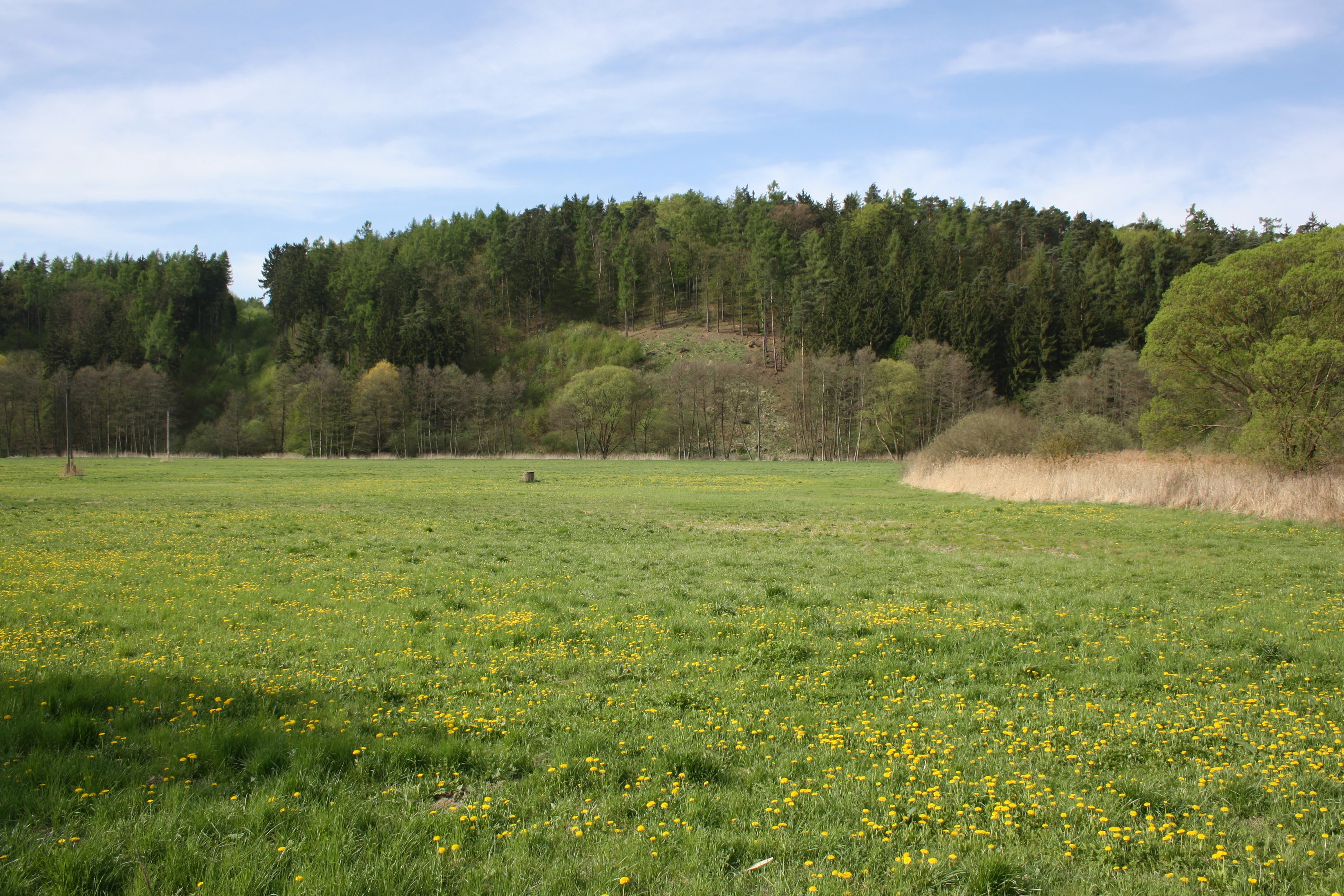
A wide view of a grassy meadow covered in yellow wildflowers, with a dense forested hill in the background under a blue sky.
A meadow in the Bobrava Nature Park near Střelice.

Bobrava Nature Park history and protected-area timeline

Bobrava Nature Park was officially designated on 1 January 1982 as a general protected area in the Brno-venkov District, becoming part of the Czech system of přírodní parky intended to safeguard larger landscape units of regional ecological and aesthetic significance. The designation recognized the middle valley of the Bobrava River as an area of continuous forest cover with notable biological value and cultural landscape features.

Beyond the act of protected designation itself, the landscape carries deeper historical traces. Fragments of old watermills survive along the Bobrava River, including the Radostický, Spálený, Anenský, and Šafránkův mills, evidence of a long tradition of milling tied to the river's hydrology and the surrounding agricultural communities. On the summit of Bučín hill, at roughly 444 meters, faint remains of a medieval stronghold first documented in 1349 still mark the landscape, adding a layer of historical human presence to the otherwise predominantly forested terrain.

The park's elevation to formal protected status in 1982 reinforced earlier informal recognition of the valley's ecological and landscape value and placed the Bobrava area within the modern Czech conservation framework alongside similar přírodní parky of the South Moravian countryside.

Bobrava Nature Park landscape and geographic character

The landscape of Bobrava Nature Park is shaped by the central Bobrava Highlands, a low to moderately elevated highland in South Moravia characterized by wooded ridges and a meandering river valley. The terrain varies between the forested slopes above the river and the flatter valley floor, producing a varied but coherent scenery of forested hills, small clearings, and meadows.

The park extends across the middle course of the Bobrava River, with the valley reaching its lowest point near Anenský mlýn at about 250 meters and rising to higher elevations toward the west. The highest points of the park are clustered near the villages of Hlína at 461 meters and Neslovice at 452 meters, while Bučín hill at 444 meters provides a recognizable high point within the park and was historically a site of human fortification.

A defining feature of the park is the absence of permanent settlements within its boundaries. Only a few isolated farmsteads remain among the woodland, leaving the valley and slopes visually and functionally continuous. This unbroken forest-meadow landscape gives Bobrava its quiet, retreat-like atmosphere despite its proximity to Brno, and creates a natural setting shaped almost entirely by watercourses, slopes, and tree cover.

Bobrava Nature Park ecosystems, habitats, and plant life

The ecological identity of Bobrava Nature Park is dominated by extensive forest cover interrupted by the narrow valley of the Bobrava River and its damp meadows. The varied terrain of slopes and valley floors supports a mosaic of woodland habitats, small wetland pockets, and herb-rich clearings that together sustain a notably rich biodiversity for an area so close to a major urban center.

Within the park, the smaller natural monument Střelický les protects a particularly valuable forest stand, while Střelická bažinka adds an ecologically distinct wetland site to the protected network. These internal protected features complement the broader přírodní park designation by anchoring specific habitat types within the wider landscape matrix.

Amphibians are a particularly conspicuous component of the park's nature. Toads and frogs gather in spring in the valley waters for breeding, and the park is known to host several amphibian species, including the notably sensitive fire salamander in localized areas such as the Bučín massif. The combination of forest, valley wetland, and stream habitat produces an ecological gradient favorable to both forest-dependent and water-associated species.

Bobrava Nature Park wildlife and species highlights

Wildlife in Bobrava Nature Park reflects the typical pattern of a Central European river valley forest, with mammal communities that include all common forest species. Red foxes, badgers, and pine martens are typical residents alongside smaller mammals such as the Eurasian pygmy shrew, the water shrew, and the common hazel dormouse, illustrating the park's role as refuge for small mammal diversity as well as larger predators.

The park is especially notable for its birdlife, with around 98 species recorded as breeding within its boundaries. Forest raptors and characteristic woodland birds such as the northern goshawk, European honey buzzard, and black stork occur alongside corvids including the common raven, and a suite of forest specialists ranging from the Eurasian woodcock, black woodpecker, middle spotted woodpecker, golden oriole, and collared flycatcher. The white-throated dipper is regarded as a characteristic species of the park, signaling the importance of clean, structured river habitat.

Aquatic environments contribute their own suite of breeding birds, including the little grebe, water rail, and spotted crake. Amphibians are also abundant, particularly the common toad and the agile frog, which descend to the valley waters each spring to breed, with additional species such as the European tree frog, smooth newt, great crested newt, and the more localized fire salamander rounding out the herpetological interest of the park.

Bobrava Nature Park conservation status and protection priorities

Bobrava Nature Park holds conservation significance as one of the sizable green corridors immediately adjacent to Brno, the second largest city in the Czech Republic. Its declaration in 1982 as a general protected area recognized the long-term ecological value of the middle Bobrava valley and helped secure continuous forest habitat in an otherwise heavily farmed countryside.

The importance of the park is reinforced by internal designations such as the natural monuments Střelický les and Střelická bažinka, which protect specific forest stands and wetland features. These layered designations reflect a conservation approach in which broader landscape protection is combined with stricter site-level safeguards for habitats of particular sensitivity or biological richness, including amphibian breeding wetlands and mature forest communities. Together, these measures maintain habitat continuity in the Bobrava Highlands and support the persistence of breeding populations of forest birds, amphibians, and small mammals under the pressures of surrounding agricultural and suburban land use.

Bobrava Nature Park cultural meaning and human context

The cultural context of Bobrava Nature Park is closely tied to rural South Moravian life and the long history of human use of the Bobrava River valley. Scattered watermill remains along the river, including the Radostický, Spálený, Anenský, and Šafránkův mills, reflect generations of milling activity tied to the valley's hydrology and the surrounding agricultural villages. These features connect the present protected area to a broader regional heritage of river-based rural industry.

The hilltop of Bučín carries an older layer of cultural memory, where faint remnants of a medieval stronghold first documented in 1349 still occupy the forested summit at around 444 meters. Such medieval fortifications formed a wider pattern across the Moravian countryside, and their survival within the park gives the landscape a depth of human history that complements its natural value.

Top sights and standout views in Bobrava Nature Park

Bobrava Nature Park's standout quality is its unspoiled forested valley just a short distance from Brno, making it a remarkably accessible natural refuge in South Moravia. Its landscapes combine the gentle ridges of the Bobrava Highlands, the meandering Bobrava River, and isolated farmsteads in a continuous tapestry of forest, meadow, and wetland.

Highlights for visitors and researchers include the rich breeding bird community with around 98 documented species, the diverse amphibian populations breeding in the valley wetlands each spring, and the layered conservation network that pairs the broad přírodní park designation with tighter protections at Střelický les and Střelická bažinka. The historic watermill fragments and the medieval fortification remains on Bučín hill add a cultural dimension that sets Bobrava apart from purely ecological landscapes.

Best time to visit Bobrava Nature Park

Bobrava Nature Park is a year-round landscape with a strong seasonal character shaped by its forested valley setting. Spring is a particularly rewarding period because amphibians concentrate around the valley waters to breed, and the forest canopy opens with fresh foliage, creating lively conditions for observing wetland and woodland wildlife.

Late spring and early summer also bring peak bird activity, when many of the roughly 98 breeding species are most vocal and visible. Autumn brings stable weather and richly colored forest scenery, while winter offers a quiet, atmospheric experience of the South Moravian highlands when the deciduous trees reveal the underlying topography of the valley and ridges.

Monthly climate preview

Long-term temperature and precipitation averages across twelve months

Přírodní park Bobrava Climate Normals and Annual Weather Patterns

Representative coordinates record measurable shifts in mean monthly temperatures from sub-zero winter lows to warm summer maximums alongside varying daily precipitation rates. Detailed climate normals across the complete annual cycle provide deeper insight into long-term environmental patterns throughout the protected landscape.
Annual mean9 °C
-3 °C20 °C
Jan-3°
Feb-1°
Mar
Apr
May14°
Jun18°
Jul20°
Aug20°
Sep15°
Oct
Nov
Dec-2°
Warmest month
July

20.4 °C

Coolest month
January

-2.8 °C

Wettest month
June

2.5 mm/day

Driest month
February

1 mm/day

Park location guide

Geography guide, regional context, and park location map for Bobrava Nature Park

Bobrava Nature Park park geography, regions, and map view in Czechia

Understand where Bobrava Nature Park sits in Czechia through a broader geographic reading of the surrounding landscape, nearby location context, and its mapped position within the national park landscape.

How Bobrava Nature Park fits into Czechia

Czech Republic is a landlocked Central European country with a population of approximately 10.9 million people. The nation was established as an independent state on January 1, 1993, following the dissolution of Czechoslovakia. Its capital and largest city is Prague, with other major urban centers including Brno, Ostrava, Plzeň, and Liberec.

Wider geography shaping Bobrava Nature Park in Czechia

The Czech Republic is a landlocked country in Central Europe. It is bordered by Germany to the west, Austria to the south, Poland to the northeast, and Slovakia to the southeast. The landscape is predominantly hilly, with the territory covering 78,871 square kilometers.

Map view of Bobrava Nature Park

Use this park location map to pinpoint Bobrava Nature Park in Czechia, understand its exact geographic position, and read its mapped placement within the surrounding landscape more clearly.

Pigeon | © OpenStreetMap contributors

Location context for Bobrava Nature Park

Brno-venkov District

Explore photographic records of the river valley, wooded ridges, and protected habitats.

Přírodní park Bobrava Photos: Visualizing the Forested Valley and Highlands Landscape

Visual documentation captures the continuous forest canopy, meandering river channels, and lowland terrain of the Bobrava Highlands. Photographic records help researchers and visitors examine the protected landscape character, valley ecosystems, and natural topography.

A wide view of a grassy meadow covered in yellow wildflowers, with a dense forested hill in the background under a blue sky.

Park atlas

Compare adjacent highland forests and regional protected landscapes across South Moravia

Explore Other Parks Near Přírodní Park Bobrava And Surrounding Protected Areas

Browse other parks near Přírodní park Bobrava to examine connected river valleys, forested ridges, and regional wildlife habitats. Expanding the geographical comparison reveals how surrounding protected landscapes share similar highland terrain and conservation traits.
A watercolor painting showing a stylized, panoramic view of green rolling hills and evergreen trees under a soft, light-colored sky.
Nature reserveJihomoravský kraj
About 4.3 km away#1 closest

West

Rybičková skála Nature Reserve: Paleontological and Geological Landscape in Jihomoravský kraj

A preserved Permian fossil site in the Boskovice Furrow

Rybičková skála acts as a vital reference point for Permian sedimentary studies in central Europe. The site features a 40 meter cliff exposing mudstones and siltstones rich in fish fossils. Framed by mixed oak-hornbeam forests and rural Moravian farmland, this compact reserve represents a convergence of deep geological time and traditional landscape character.

Area
0.001 km²
Established
1980
IUCN
III
Relief
Upland
Natural monumentJihomoravský kraj
About 12 km away#2 closest

Northeast

Skalky u Přehrady: Protected Natural Monument and Mapped Landscape in Jihomoravský kraj

Ecologically significant forest steppe and river gorge terrain

Skalky u Přehrady is a protected natural monument characterized by its rugged diorite cliffs and diverse plant communities. The site serves as a compact example of forest steppe mosaic situated along the Svratka River, offering significant insight into the regional geography and conservation status of rocky slopes within the South Moravian territory.

Area
0.013 km²
Established
1989
IUCN
IV
Relief
Upland
A soft watercolor illustration showing a landscape with rolling hills in the background, a cluster of green trees, and a rocky outcrop on the right side.
Natural monumentJihomoravský kraj
About 13 km away#3 closest

North

Na Skalách Natural Monument: A Protected Limestone Landscape in the South Moravian Highlands

Geographic study of relict oak woodland and cliffside terrain.

Na Skalách stands as a vital natural monument within Jihomoravský kraj, preserving a steep, south-facing limestone slope along the Svratka River gorge. This compact area offers a window into thermophilic oak forest communities and calcareous rock vegetation, showcasing high botanical value and geological diversity despite its small surface area.

Area
0.01 km²
Established
1991
IUCN
IV
Relief
Upland
Protected landscapeBrno-venkov District
About 14 km away#4 closest

North

Přírodní park Údolí Bílého potoka: Protected Landscape in the South Moravian Region

Forested stream valley geography and upland terrain mapping

This protected area centers on the deep, forested valley of the Bílý potok stream. It features a rich mosaic of beech-fir and oak-pine forests on rocky slopes, representing a significant ecological corridor in the agricultural landscape northwest of Brno within the Brno-venkov District.

Area
40.46 km²
Established
1978
Relief
Upland
Climate
Temperate
A horizontal watercolor painting showing rolling green hills with small patches of trees under a soft, pale sky.
Natural monumentJihomoravský kraj
About 14 km away#5 closest

Northeast

Medlánecké kopce Natural Monument: Exploring Protected Steppe Habitats in Northern Brno

A rare mosaic of dry grasslands and rocky outcrops in Jihomoravský kraj

Medlánecké kopce preserves a critical landscape of thermophilic flora and insect communities on the edge of the Brno basin. The site is noted for its xerothermic vegetation, including the large-flowered pasqueflower, which thrives on its unique metabasite and loess soil composition. This protected area offers a look at how specialized steppe ecosystems persist within a heavily developed regional environment.

Area
0.118 km²
Established
1988
IUCN
IV
Relief
Upland
A soft watercolor painting showing a rolling landscape with hills, scattered trees, and rocky outcrops, rendered in pastel greens and pinks.
Natural monumentBrno
About 15 km away#6 closest

Northeast

Medlánecká skalka Natural Monument: Mapped Protected Landscapes and Geography in Brno

A rare urban-adjacent steppe and rocky habitat site

Medlánecká skalka is a protected natural monument located in the Medlánky district of Brno, Czech Republic. Spanning a small but significant rocky slope, this site preserves thermophilous dry-grassland communities and essential habitats for rare flora like the Pulsatilla grandis. Its unique topography and skeletal soil composition make it an important geographic reference point for understanding steppe-like ecosystems in the South Moravian region.

Area
0.003 km²
Established
1999
IUCN
IV
Relief
Upland
A minimalist watercolor illustration showing rolling green hills and a few trees against a pale yellow and pink background.
Protected landscapeCzechia
About 15 km away#7 closest

Northeast

Přírodní park Baba: A Detailed Geographic Overview of this Czech Protected Landscape

Forested ridges and centuries-old oak woodland topography

Přírodní park Baba is a protected area in Czechia characterized by a continuous six-kilometer ridge rising above the surrounding urban landscape of Brno. This site is defined by its deep-rooted, century-old sessile oak stands and an intricate mosaic of meadows supporting rare orchid species and diverse avian life. Its geological foundation, composed of Paleozoic diorite, supports a resilient ecosystem that serves as a vital natural corridor between Brno and Kuřim.

Area
8.89 km²
Established
1990
Relief
Mountain
Climate
Temperate
Natural monumentJihomoravský kraj
About 17 km away#8 closest

East

Velké Družďavy Natural Monument: Steppe Geography and Protected Landscapes in Jihomoravský kraj

Rare xerothermic habitats on Miocene sandy substrates

Velké Družďavy represents a vital, small-scale protected area in the Czech Republic. Defined by its south-facing slope and sandy Miocene substrate, the site supports significant populations of thermophilic plants. This natural monument illustrates the challenges of managing xerothermic steppe vegetation against encroaching forest succession, providing a distinct geographic focal point within the regional protected area network of South Moravia.

Area
0.014 km²
Established
1953
IUCN
IV
Relief
Upland

Common questions about visiting, size, designation, and location context for Bobrava Nature Park

Bobrava Nature Park FAQs for park facts, access, geography, and protected area context

Find quick answers about Bobrava Nature Park, including protected-area facts, park geography, trail and visitor context, and how the park fits into its surrounding country and regional landscape.
MoriAtlas Explorer

Continue Your Protected Areas Search Across the Global Atlas

Deepen your exploration by continuing the structured search for national parks and protected areas worldwide. Utilize the comprehensive filtering capabilities to compare different conservation landscapes and refine your understanding of global park geography. Discover more about the distribution and characteristics of protected natural areas.

Global natural geography