Mori Atlas logo
Marine protected areaPujada Bay Protected Seascape

A comprehensive look at the protected marine landscapes, seagrass meadows, and bay topography of Mindanao

Pujada Bay Protected Seascape: Mapping the Marine and Coastal Geography of Davao Oriental

Pujada Bay Protected Seascape sits along the southeastern coast of Mindanao, functioning as a critical marine and coastal reserve within the Davao Oriental province. This protected area encompasses an expansive bay where mountainous interior terrain meets diverse shoreline ecosystems including extensive mangrove forests, seagrass meadows, and fringing coral reefs. The surrounding geography, framed by the Guang-Guang Peninsula and various mountain-fed river systems, creates a unique basin environment that supports significant marine biodiversity and stable coastal habitats.

Mindanaocoastal protected areamarine protected areamangrove forestseagrass bedscoral reefs

Pujada Bay Protected Seascape

Marine protected area

Park overview

Structured park overview, official facts, and landscape profile for Pujada Bay Protected Seascape

Pujada Bay Protected Seascape park facts, protected area profile, and essential visitor context

Review the core facts for Pujada Bay Protected Seascape, including designation, size, terrain, visitor scale, habitats, and operating context in one park-focused overview.

About Pujada Bay Protected Seascape

Pujada Bay Protected Seascape is a coastal and marine protected area situated along the eastern coast of Mindanao in the southern Philippines. Designated under Presidential Proclamation 431 on 31 July 1994, it encompasses roughly 21,200 hectares of waters, shoreline, and coastal land around Pujada Bay in Davao Oriental. The seascape represents one of the more significant coastal conservation initiatives in the Davao region and forms part of a broader network of protected landscapes and seascapes in southeastern Mindanao.

The physical setting of the bay strongly shapes its ecological character. The northern and western coasts are bordered by hilly to mountainous terrain, while flatter lowlands stretch along much of the eastern shoreline. The Guang-Guang Peninsula, described as gently rolling to hilly, extends into the southern portion of the bay and helps frame the enclosed body of water. Several river systems descend from these surrounding landforms and discharge into the bay, with the Catmonan, Dawan, Dilaon, Mati, Matiao, and Guang-Guang among the more prominent streams contributing freshwater and sediments to the coastal system.

Ecologically, the seascape is defined by the convergence of three foundational coastal habitats: mangroves, seagrass meadows, and coral communities. Mangrove forests line an estimated 850 hectares of the coastline, providing critical nursery habitat for fish and crustaceans, shoreline stabilization, and carbon storage. The seagrass beds within the bay support nine of the seagrass species documented for the Philippines, a substantial share of the country's seagrass diversity for a single bay. Coral surveys have identified 25 coral species within the protected waters, further underscoring the bay's marine biodiversity.

Beyond its ecological role, the seascape contributes to the identity of Davao Oriental and to broader Mindanao coastal conservation efforts. Together with neighboring protected areas such as the Mati Protected Landscape and the Baganga Bay Protected Landscape and Seascape, it forms an important cluster of coastal reserves in the region. Its proximity to Mati City anchors it within the surrounding community, where coastal resources are closely tied to local livelihoods, fishing traditions, and environmental awareness. The protected area thus stands as both a regional ecological asset and a defining feature of the eastern Mindanao coast.

Quick facts and research context for Pujada Bay Protected Seascape

Pujada Bay Protected Seascape lies in Davao Oriental on the southeastern coast of Mindanao, with Mati City as the nearest urban center. The protected area was proclaimed on 31 July 1994 under Presidential Proclamation 431 and covers approximately 212 square kilometers, or around 21,200 hectares, of coastal and marine waters.

The bay's habitat complex includes extensive mangrove forests, diverse seagrass beds, and coral communities that together account for the area's main ecological value. The surrounding terrain transitions from lowlands along much of the coast to hilly and mountainous landmasses along the northern and western shores, while the Guang-Guang Peninsula forms a defining southern headland. The bay falls within Climate Type IV of the Philippine classification system, characterized by rainfall distributed throughout the year rather than sharply separated wet and dry seasons, and lies outside the main Pacific typhoon belt.

Protection and recognition

Marine conservation scope and international designation records

Pujada Bay Protected Seascape Protection Status and Recognition

Marine conservation records outline the official protection status and management scope established for Pujada Bay Protected Seascape. Documented recognition data details international designations and administrative boundaries associated with this protected area.

Protection details

Protection scope
Marine
Transboundary protection
No
Park context

Deeper park guide and search-rich context for Pujada Bay Protected Seascape

Pujada Bay Protected Seascape history, landscape, wildlife, and travel context

Explore Pujada Bay Protected Seascape through its history, landscape character, ecosystems, wildlife, conservation priorities, cultural context, and seasonal travel timing in a structured park guide built for atlas discovery and search intent.

Why Pujada Bay Protected Seascape stands out

Pujada Bay Protected Seascape is best known for the interplay of mangroves, seagrass beds, and coral habitats along a single Mindanao bay. The protected area hosts substantial mangrove cover along its shoreline, supports a notable proportion of the seagrass species recorded for the Philippines, and contains documented coral diversity within its waters. The bay is also recognized for the way its surrounding landscape frames the marine environment. Hills and mountains rise to the north and west, while the broad Guang-Guang Peninsula defines the southern shoreline, creating varied conditions for coastal habitats. This combination of terrestrial relief and marine ecosystems gives the seascape its distinctive identity among protected coastal areas in the Davao region.

Pujada Bay Protected Seascape history and protected-area timeline

Pujada Bay Protected Seascape was formally proclaimed a protected area on 31 July 1994 through Presidential Proclamation 431, reflecting the Philippine government's recognition of the bay's ecological significance. The proclamation established the legal and institutional framework for managing the bay as a marine and coastal reserve within the broader national protected area system.

The designation placed roughly 21,200 hectares of coastal and marine waters under protection, with the Department of Environment and Natural Resources as the lead government agency responsible for its oversight. The protected status was intended to conserve mangrove habitats, seagrass beds, and reef-associated ecosystems that were increasingly subject to pressures from coastal development, fishing, and land-based activities in eastern Mindanao.

Since its establishment, the seascape has been managed alongside other protected areas in the Davao region as part of an integrated approach to conserving Mindanao's coastal biodiversity. Information about the area has been disseminated through publications of the Department of Environment and Natural Resources, which have supported both public awareness and the ongoing management of the reserve.

Pujada Bay Protected Seascape landscape and geographic character

The landscape of Pujada Bay Protected Seascape is shaped by the meeting of mountainous interior terrain with a large open bay along Mindanao's southeastern coast. To the north and west of the bay, the land rises into hilly and mountainous country, much of it covered in vegetation that drains downslope through several streams and rivers emptying into the bay's waters. These landforms create a relatively enclosed basin that buffers wave action and helps maintain calm conditions favorable to seagrass and coral habitat development.

Along the eastern side of the bay, the terrain is generally flatter, with lowland areas extending toward the coast. The Guang-Guang Peninsula forms the southern arm of the bay and is described as gently rolling to hilly, gradually rising from sea level. This peninsula, together with the mainland shoreline to the west, gives the bay its broad, roughly semi-enclosed shape.

Multiple rivers converge on the bay from the surrounding slopes. The Catmonan, Dawan, Dilaon, Mati, Matiao, and Guang-Guang rivers are among the more notable freshwater inputs, delivering nutrients and sediment that influence water conditions and ecological productivity. The result is a coastal landscape where terrestrial relief and marine waters interact closely, producing the varied shoreline habitats that make the seascape ecologically distinctive.

Pujada Bay Protected Seascape ecosystems, habitats, and plant life

The ecological identity of Pujada Bay Protected Seascape is rooted in three interconnected coastal ecosystems: mangrove forests, seagrass meadows, and coral communities. These habitats together support the diversity of marine and shoreline life that the protected area was established to conserve.

Mangrove forests form one of the most prominent features of the seascape, extending approximately 850 hectares along the bay's coastline. These mangroves stabilize sediments, reduce coastal erosion, and provide nursery habitat for fish, crustaceans, and other marine organisms. The dense mangrove cover, distributed along much of the shoreline, is a defining structural element of the bay's coastal system.

Seagrass beds constitute the second major habitat layer within the bay. Surveys have documented nine seagrass species within Pujada Bay, representing a substantial portion of the sixteen seagrass species recorded for the Philippines as a whole. These submerged meadows contribute to primary productivity in coastal waters, support grazing animals, and help trap sediments that would otherwise affect coral health.

Coral communities represent the third main ecosystem component. Twenty-five coral species have been identified in the waters of the protected area, indicating the bay's importance for reef-associated biodiversity. The combination of clear, sheltered waters, seagrass productivity, and mangrove-driven nutrient cycling provides a favorable setting for these corals. Altogether, mangroves, seagrass beds, and corals function as an integrated coastal ecosystem, each habitat reinforcing the structure and resilience of the others.

Pujada Bay Protected Seascape wildlife and species highlights

The protected waters and shoreline of Pujada Bay harbor the faunal communities associated with healthy mangrove, seagrass, and coral ecosystems. Mangrove fringes provide shelter and breeding habitat for juvenile fish and invertebrates, while the seagrass meadows support grazing marine life and serve as foraging grounds for a variety of species that depend on shallow-water productivity.

The bay's coral communities, with documented species richness across multiple coral taxa, indicate the presence of associated reef-dwelling fish and invertebrates. These reef-supporting communities contribute to the broader marine food web of the bay, linking benthic habitat structure to higher trophic levels.

Because the seascape encompasses an entire bay and its coastal catchments, the protected area also buffers wildlife populations in the surrounding watershed. Streams flowing into the bay connect inland terrestrial habitats with coastal and marine environments, allowing ecological processes to extend beyond the shoreline itself. While detailed species inventories are not comprehensively documented in the available sources, the bay's recognized habitat complexity and its role within the Davao region suggest meaningful wildlife value consistent with its protected status.

Pujada Bay Protected Seascape conservation status and protection priorities

Pujada Bay Protected Seascape was established to protect an integrated coastal ecosystem of recognized biological importance in southeastern Mindanao. Its designation under Presidential Proclamation 431 in 1994 reflects a national-level commitment to conserving mangroves, seagrass beds, and coral habitats as a single connected system rather than as isolated features.

The seascape's conservation value lies in the concentration of three foundational habitats within a single bay. Mangrove forests covering around 850 hectares of coastline, seagrass meadows holding nine of the Philippines' sixteen recorded seagrass species, and coral communities with twenty-five documented species collectively represent significant proportions of the country's coastal biodiversity. Protecting these habitats together helps maintain ecological functions such as shoreline stabilization, nutrient cycling, and fisheries support that would be diminished if any one component were lost.

The protected area is administered within the framework of the Philippine national protected area system, under the oversight of the Department of Environment and Natural Resources. As part of a cluster of coastal conservation sites in the Davao region, including nearby Mati Protected Landscape and Baganga Bay Protected Landscape and Seascape, it contributes to a wider network of reserves that collectively strengthen marine and coastal resilience along Mindanao's eastern coast.

Pujada Bay Protected Seascape cultural meaning and human context

Pujada Bay has long been part of the coastal identity of Davao Oriental and the surrounding communities of southeastern Mindanao. The bay's waters and shoreline have supported local fishing traditions and small-scale coastal livelihoods, with the Mati River and other streams linking inland settlements to the bay's resources. The protected area sits adjacent to Mati City, the provincial capital of Davao Oriental, anchoring the seascape within a community that depends on the coast for both daily life and economic activity.

The proclamation of the bay as a protected seascape in 1994 also reflects a growing national and local awareness of the need to balance coastal resource use with long-term ecological sustainability. Although specific indigenous or historical cultural details are not extensively documented in available sources, the bay sits within a region of Mindanao known for diverse coastal communities and for the close cultural relationship between people and the sea.

Top sights and standout views in Pujada Bay Protected Seascape

Pujada Bay Protected Seascape stands out for the convergence of mangrove forests, seagrass beds, and coral reefs within a single Mindanao bay. Its roughly 850 hectares of mangroves, nine documented seagrass species, and twenty-five coral species place it among the more ecologically rich coastal reserves in the Davao region. The bay's setting, framed by hills, mountains, and the Guang-Guang Peninsula, gives it a distinctive physical character that complements its marine biodiversity.

Best time to visit Pujada Bay Protected Seascape

Because the bay lies within Climate Type IV and outside the main Pacific typhoon belt, it does not experience sharply defined wet and dry seasons. Rainfall is distributed throughout the year, and conditions tend to remain relatively calm compared with more typhoon-exposed parts of the Philippines. As a result, the bay's coastal and marine environments can be appreciated across much of the year, with calmer waters generally favoring visibility and outdoor coastal experience. Travelers should consider that conditions along the coast and within the bay vary with broader regional weather patterns typical of southeastern Mindanao.
Monthly climate preview

Long term temperature and precipitation measurements across the representative coordinate

Pujada Bay Protected Seascape Climate Normals and Annual Weather Patterns

Representative coordinates record consistent monthly average temperatures alongside recorded daily precipitation rates spanning from four to nine millimeters. Detailed twelve month climate profiles provide deeper analytical context regarding thermal ranges and precipitation rhythms across the protected seascape.
Annual mean26 °C
26 °C27 °C
Jan26°
Feb26°
Mar26°
Apr27°
May27°
Jun27°
Jul26°
Aug26°
Sep26°
Oct27°
Nov27°
Dec26°
Warmest month
May

27 °C

Coolest month
February

25.8 °C

Wettest month
January

8.6 mm/day

Driest month
April

4.6 mm/day

Park location guide

Geography guide, regional context, and park location map for Pujada Bay Protected Seascape

Pujada Bay Protected Seascape park geography, regions, and map view in Philippines

Understand where Pujada Bay Protected Seascape sits in Philippines through a broader geographic reading of the surrounding landscape, nearby location context, and its mapped position within the national park landscape.

How Pujada Bay Protected Seascape fits into Philippines

The Philippines, officially the Republic of the Philippines, is an archipelagic nation in Southeast Asia comprising approximately 7,641 islands categorized into three main geographical divisions: Luzon, Visayas, and Mindanao. Located in the western Pacific Ocean, it shares maritime borders with Taiwan, Japan, Palau, Indonesia, Malaysia, Vietnam, and China. Manila serves as the capital city, while Quezon City is the most populated city, both within Metro Manila.

Wider geography shaping Pujada Bay Protected Seascape in Philippines

The Philippines is an archipelagic nation in Southeast Asia, positioned in the western Pacific Ocean. Its islands are bounded by the South China Sea to the west, Philippine Sea to the east, and Celebes Sea to the south. The country shares maritime borders with Taiwan to the north, Japan to the northeast, Palau to the east and southeast, Indonesia to the south, Malaysia to the southwest, Vietnam to the west, and China to the northwest.

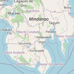
Map view of Pujada Bay Protected Seascape

Use this park location map to pinpoint Pujada Bay Protected Seascape in Philippines, understand its exact geographic position, and read its mapped placement within the surrounding landscape more clearly.

Pigeon | © OpenStreetMap contributors

Location context for Pujada Bay Protected Seascape

Davao Oriental
Park atlas

Compare nearby protected areas and regional marine reserves across Mindanao

Other Parks Near Pujada Bay Protected Seascape And Surrounding Coastal Regions

Browse protected areas and coastal reserves situated near Pujada Bay Protected Seascape to examine related marine and terrestrial habitats across the region. Extending the geographic comparison reveals broader patterns of conservation, shoreline terrain, and regional biodiversity networks.
A watercolor illustration of a mountain range with green, yellow, and soft pink hues, featuring rolling hills and forested slopes in a panoramic format.
National parkPhilippines
About 90 km away#1 closest

West

Mount Apo Natural Park: Volcanic Terrain and Biodiversity in Mindanao, Philippines

Mapping the highest peak and endemic-rich montane ecosystems

Spanning the provinces of Davao del Sur and Cotabato, Mount Apo Natural Park protects the volcanic massif of Mount Apo and its extensive forest surroundings. The park exhibits a distinct altitudinal zonation that supports a significant concentration of endemic birds, mammals, and plant life. Beyond its ecological relevance, the area features dramatic volcanic ridges, cascading waterfalls, and the high-elevation Lake Venado, forming a vital component of the regional natural heritage network in the southern Philippines.

Area
640.53 km²
Established
2004
Relief
Mountain
Climate
Tropical
A watercolor painting showing a soft, peaceful scene with green rolling hills, a calm bay or river in the foreground, and a pale pink and yellow sky.
National parkSarangani
About 153 km away#2 closest

Southwest

Sarangani Bay National Park: Regional Geography and Protected Seascape Atlas

Coastal landscapes and maritime boundaries in southern Mindanao

Sarangani Bay represents a unique intersection of heavy maritime commerce and formal protected-area status. Stretching across the southern coastline of Mindanao, the bay provides a vital anchor for regional geography and ecological oversight. Examine the mapped extent, coastal municipalities, and the integration of this expansive marine environment into the national protected-area system.

Established
2018
Relief
Lowland
Scope
Marine
Water
Water-dominated
A horizontal watercolor painting showing a calm lake in the foreground with lush green hills and distant mountain ridgelines in the background.
Protected areaMaguindanao del Sur
About 159 km away#3 closest

West

Lake Buluan Protected Area: An Atlas Guide to Mindanao Lowland Freshwater Landscapes

Geography and hydrological map of the Maguindanao del Sur wetlands.

Lake Buluan represents a vast, shallow freshwater system known for its extensive marshes and role as a central basin for multiple Mindanao river tributaries. As a protected landscape in Maguindanao del Sur, it offers a distinct look at lowland hydrological patterns, floodplain dynamics, and the cultural history associated with the region's inland water resources.

Area
61.34 km²
Relief
Lowland
Water
Water-dominated
Wildlife reserveAgusan del Sur
About 167 km away#4 closest

North

Agusan Marsh Wildlife Sanctuary: Mapping a Vast Freshwater Protected Area

Swamp forests and river basin geography in Agusan del Sur

Agusan Marsh Wildlife Sanctuary represents a crucial freshwater wetland complex within the Agusan River basin. The area is defined by its expansive swamp forests and semi-permanent floating lakes, which serve as essential migratory transit points and support an intricate network of aquatic ecosystems across the Mindanao region.

Area
148.36 km²
Established
1996
IUCN
IV
Relief
Lowland
National parkLanao del Sur
About 213 km away#5 closest

Northwest

Rungkunan National Park: Mapped Protected Landscape and Regional Geography Overview

Discover Rungkunan National Park's protected boundaries and landscape context.

Gain insight into Rungkunan National Park, a protected national park situated in Lanao del Sur. This page details the park's geographic positioning, mapped outlines, and its significance as a conservation landscape. It provides essential context for understanding the distribution of protected areas and the regional geography of the Philippines, facilitating a deeper atlas-style exploration.

Established
1965
IUCN
V
Water
Minor water
National parkMaguindanao del Norte
About 214 km away#6 closest

West

Mado Hot Spring National Park: Protected Geothermal Landscape in Maguindanao del Norte

Explore its therapeutic hot springs and mapped boundaries

Mado Hot Spring National Park, located in Maguindanao del Norte, Philippines, is a protected area defined by its geothermal features and therapeutic hot springs. This national park, established early in the Philippines' conservation history, offers a unique landscape centered around a warm mineral-rich natural pool. Delve into the geographic context and protected area identity of this distinctive site, understanding its role within the region's natural heritage.

Area
0.48 km²
Established
1939
IUCN
II
Scope
Terrestrial
National parkLanao del Sur
About 218 km away#7 closest

Northwest

Salikata National Park: Explore Philippines National Park Geography

Mapped protected area boundaries and regional context.

Investigate Salikata National Park, a key protected area designated as a national park within Lanao del Sur, Philippines. This detailed view provides essential context for understanding its mapped boundaries, its place in the regional geography, and its significance as a protected landscape. Discover the unique geographic attributes that define Salikata National Park for atlas-based exploration.

Established
1965
IUCN
V
Relief
Mountain
Climate
Tropical
Nature reserveAgusan del Sur
About 226 km away#8 closest

North

Andanan Watershed Forest Reserve: Protected Landscape and Watershed Geography in Agusan del Sur

Exploring the Diwata Mountains and Andanan River headwaters

Spanning mountainous terrain in Agusan del Sur, the Andanan Watershed Forest Reserve acts as a primary catchment area for the Andanan River system. This nature reserve sustains a mosaic of forest and grassland habitats within the Diwata Mountains, representing a vital node in the regional protected-area network of Mindanao.

Area
150.97 km²
Established
1991
Relief
Mountain
Scope
Terrestrial

Common questions about visiting, size, designation, and location context for Pujada Bay Protected Seascape

Pujada Bay Protected Seascape FAQs for park facts, access, geography, and protected area context

Find quick answers about Pujada Bay Protected Seascape, including protected-area facts, park geography, trail and visitor context, and how the park fits into its surrounding country and regional landscape.
MoriAtlas Explorer

Continue Your Protected Areas Search Across the Global Atlas

Deepen your exploration by continuing the structured search for national parks and protected areas worldwide. Utilize the comprehensive filtering capabilities to compare different conservation landscapes and refine your understanding of global park geography. Discover more about the distribution and characteristics of protected natural areas.

Global natural geography