
Mori Atlas logo
Nature reserveQuellgebiet der Weißen Gelster

Examining the geography of calcareous spring mires and wet meadow ecosystems in northern Hesse

Quellgebiet der Weißen Gelster Nature Reserve: Mapped Protected Landscapes in Werra-Meißner-Kreis

Quellgebiet der Weißen Gelster forms a protected nature reserve nestled within the rural landscape of the Werra-Meißner-Kreis in Germany. This site preserves a distinctive mosaic of spring-fed fens, sedge communities, and montane grasslands that rely on base-rich, groundwater-influenced soils. By mapping the terrain and ecological boundaries of this habitat, the area reveals its critical role as a refuge for specialized flora within the broader eastern Hessian highlands.

spring mirecalcareous fensedge fenwet meadowmontane meadownature reserve
An illustration of a green mountain valley with a waterfall flowing down a cliff, a winding river in the foreground, and colorful wildflowers.

Quellgebiet der Weißen Gelster

Nature reserve

Park overview

Structured park overview, official facts, and landscape profile for Quellgebiet der Weißen Gelster

Quellgebiet der Weißen Gelster park facts, protected area profile, and essential visitor context

Review the core facts for Quellgebiet der Weißen Gelster, including designation, size, terrain, visitor scale, habitats, and operating context in one park-focused overview.

About Quellgebiet der Weißen Gelster

The Quellgebiet der Weißen Gelster sits in a modest, open agricultural valley on the northwestern margin of the Hoher Meißner, one of the most prominent massifs of the Osthessisches Bergland in northern Hesse. Although it is small, measuring only about eleven hectares, the reserve concentrates a striking variety of wetland and meadow habitats on calcareous, groundwater-influenced soils derived from Keuper sediments. Cold base-rich springs rise across the area and feed several channels that become the young Laudenbach, the stream whose cloudy appearance after storms gives the site its "Weiße Gelster" identity.

The reserve was set aside in April 1991 to shield these spring-fed mires, tall herb fringes, sedge stands, and nutrient-poor moist grasslands from the pressures of surrounding farmland. The vegetation has accumulated over decades of low-intensity management, combined with phases of abandonment followed by late-summer mowing under conservation contracts from the mid-1980s onward. This history has produced a species-rich, structurally varied habitat mosaic that supports rare sedges, rushes, orchids, bryophytes, butterflies, and a guild of open-country breeding birds.

Beyond its botanical and faunal value, the reserve is embedded in a much larger network of European conservation designations. It is part of the Meißner und Meißner Vorland Fauna-Flora-Habitat area, which protects montane meadow types, woodland, and species such as the Eurasian lynx, Bechstein's bat, and lady's slipper orchid. It also adjoins the Meißner European bird protection zone, a landscape recognised for its woodland and forest-edge bird communities, including black stork, peregrine falcon, and red kite. The result is a small but ecologically intense reserve that reflects the wider character of the Meißner region as one of Hesse's most important natural and cultural landscapes.

Quick facts and research context for Quellgebiet der Weißen Gelster

The Quellgebiet der Weißen Gelster is a German Naturschutzgebiet located in the Werra-Meißner-Kreis of northern Hesse, within the natural region known as the Velmeder Tal. It lies at roughly 360 to 410 metres above sea level, south of Laudenbach and between the villages of Laudenbach and Velmeden, on the northwestern slope of the Meinetsberg below the Hoher Meißner. The reserve was established in April 1991 by order of the Regierungspräsidium Kassel and covers about 11.47 hectares. Its official national identifier is 1636022, and its protected-planet WDPA code is 165060. Administratively the area is part of the Geo-Naturpark Frau-Holle-Land and lies within the Meißner und Meißner Vorland Fauna-Flora-Habitat site, as well as forming part of the buffer to the Meißner European bird protection zone.

Protection and recognition

Review documented terrestrial protection scope and baseline conservation data

Quellgebiet der Weißen Gelster Protection Status and Protected Area Designation

Quellgebiet der Weißen Gelster maintains a documented terrestrial protection scope within the global conservation database. Structured records outline baseline designation metrics and international recognition frameworks for the protected area.

Protection details

Protection scope
Terrestrial
Transboundary protection
No
WDPA ID
165060
Park context

Deeper park guide and search-rich context for Quellgebiet der Weißen Gelster

Quellgebiet der Weißen Gelster history, landscape, wildlife, and travel context

Explore Quellgebiet der Weißen Gelster through its history, landscape character, ecosystems, wildlife, conservation priorities, cultural context, and seasonal travel timing in a structured park guide built for atlas discovery and search intent.

Why Quellgebiet der Weißen Gelster stands out

The reserve is best known for its calcium-rich spring mires and associated vegetation, including Davall's sedge fen, blue moor grass meadows, and golden oat meadows that have developed on calcareous Keuper soils. It is valued as a refuge for regionally rare and Red-Listed plant species such as Trollblumen, arnica, Davall's sedge, various orchids, and a suite of calcareous bryophytes. It is also notable as the source area of the Weiße Gelster, a small stream whose waters famously turn a milky white after heavy rainfall as suspended calcium carbonate is flushed from the soils.
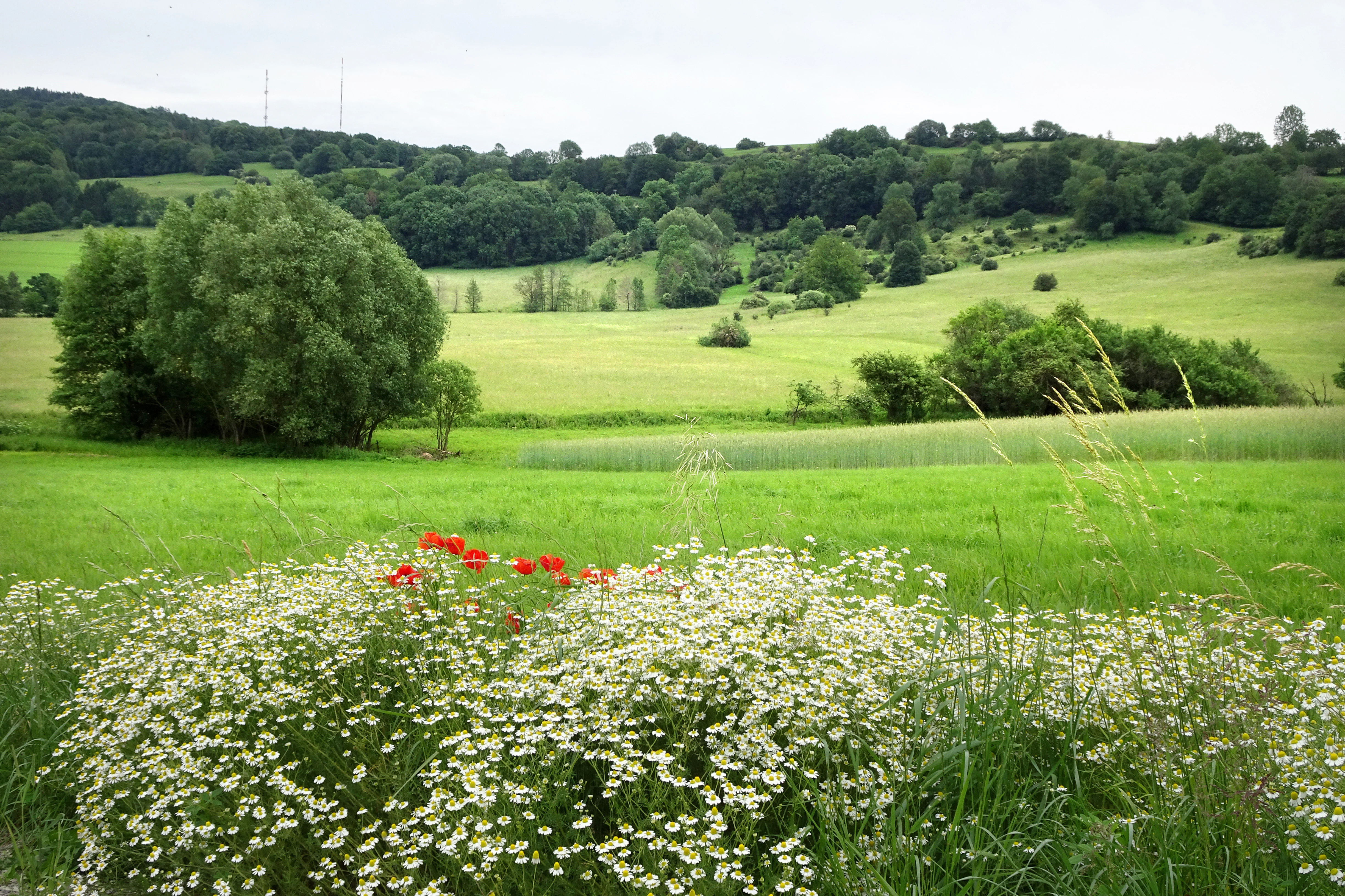
A wide view of a green meadow landscape with wild daisies and poppies in the foreground, rolling hills with forests in the background, and an overcast sky.
A lush meadow landscape in the Quellgebiet der Weißen Gelster nature reserve.

Quellgebiet der Weißen Gelster history and protected-area timeline

The Quellgebiet der Weißen Gelster was formally protected by order of the Regierungspräsidium Kassel on 19 March 1991, with the ordinance coming into force on 9 April 1991 following its announcement in the Hessischer Staatsanzeiger. The designation was prompted by decades of slow ecological change in the area, where extensive land use followed by long periods of abandonment allowed calcareous spring mires, tall herb communities, sedge stands, and moist and nutrient-poor meadows to accumulate rare and increasingly threatened plant species.

From the mid-1980s, conservation-minded late-summer mowing was reintroduced through management contracts with local farmers, helping to maintain the open character of the meadows and prevent successional loss of the most species-rich plant communities. In January 2008 the area's connection to the European Natura 2000 network was formalised through the Hessian ordinance on Natura 2000 sites, embedding the reserve as the westernmost sub-area of the greater Meißner und Meißner Vorland Fauna-Flora-Habitat site. The surrounding slopes of the Meinetsberg and Hoher Meißner had already achieved broader recognition through their inclusion in the Meißner European bird protection zone, reinforcing the protected status that the small spring-fed wetland enjoys today.

Quellgebiet der Weißen Gelster landscape and geographic character

The reserve occupies a low valley within the Gelstergraben, a north-south fault-bounded trench that forms part of the larger Witzenhausen-Altmorschener Talung. This landscape features Saxon-style faulting, where crustal blocks dropped and rose along fractures generated from the Late Cretaceous through the Late Pliocene. The Gelstergraben lies between two prominent Mittelgebirge: the Kaufunger Wald to the west and the Hoher Meißner to the east. The protected area itself sits at the foot of the Meinetsberg, on the western foreland of the Hoher Meißner, opening westward into the Rommeroder Hügelland.

Topographically, the valley floor is gentle and open, dominated by fields and meadows. The reserve's surface ranges from about 360 to 410 metres above sea level and is bounded on its western edge by Landstraße 3238. Soils are developed on Keuper bedrock and are predominantly groundwater-influenced gleys with a high base saturation. The climate is that of a cool, precipitation-rich upland, characteristic of the west-facing flanks of the Meißner, with vegetation phenology delayed by altitude. Despite being a small protected area, the result is a quietly distinctive micro-landscape of springs, sedge flushes, wet meadows, and fringes of tall herbs framed by farmland and low ridges.
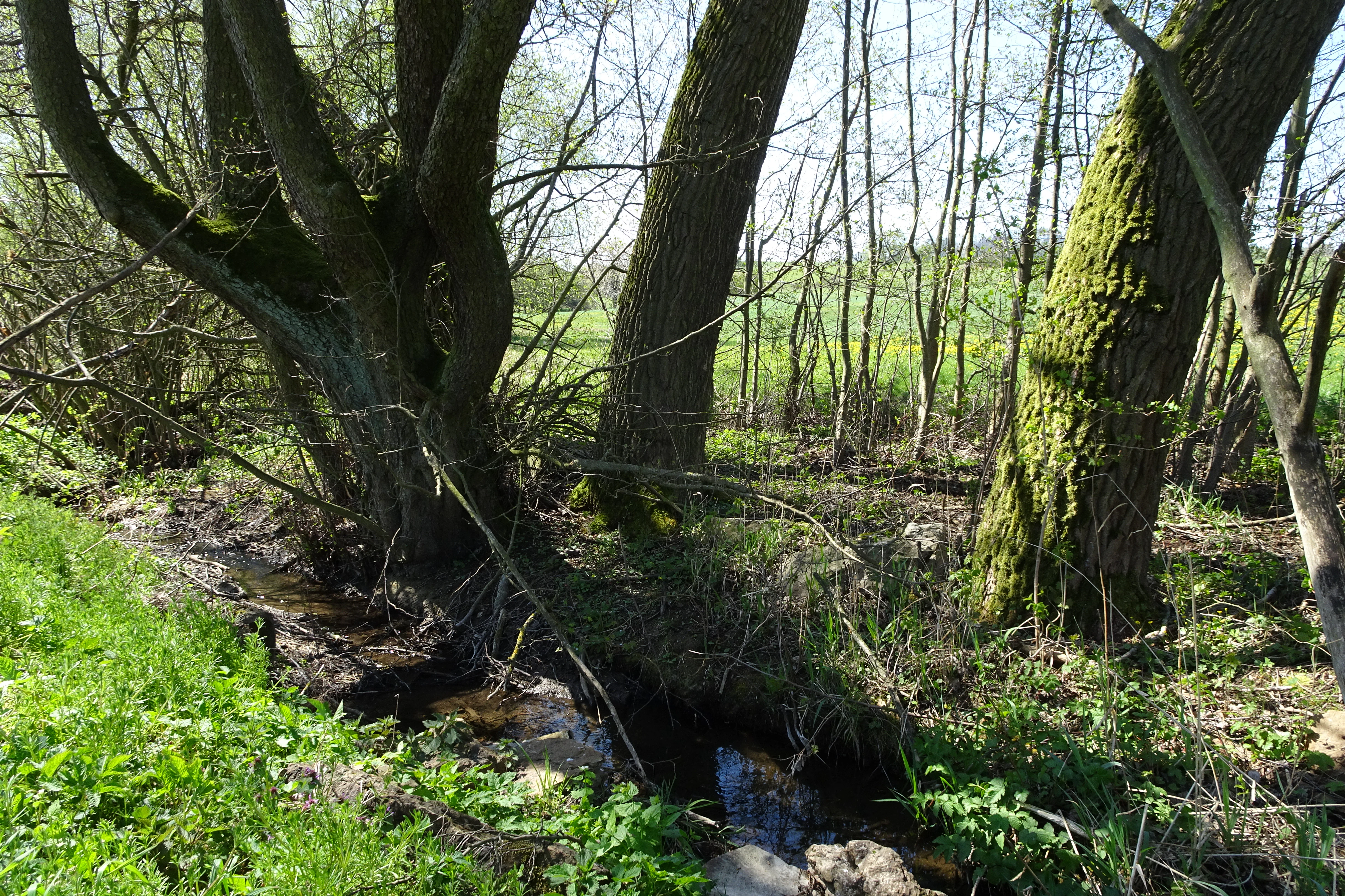
A small, narrow stream winds between mature mossy tree trunks in a lush, green spring forest setting.
A small stream flowing through the spring mire habitat of the Quellgebiet der Weißen Gelster nature reserve.

Quellgebiet der Weißen Gelster ecosystems, habitats, and plant life

The defining ecological character of the Quellgebiet der Weißen Gelster is bound up with its cold, calcium-rich springs and the constantly wet, base-rich soils they create. These conditions have produced a mosaic of vegetation types that are increasingly rare in central Europe. Davall's sedge fen is one of the reserve's signature habitats, characterised by low-growing sedges and rushes, the diagnostic Davall's sedge itself, broad-leaved cottongrass, marsh helleborine, blue sedge, yellow sedge, fen hawk's-beard, narrow-leaved cottongrass, marsh horsetail, and small valerian. The accompanying moss layer includes specialist calcareous bryophytes such as Campylium stellatum, Palustriella commutata, and the rare split-tooth moss.

Around the spring mires, blue moor grass meadows have developed on calcareous Keuper soils under extensive, low-intensity mowing regimes. These meadows, which carry species such as caraway-leaved silge, betony, yellow flax, devil's-bit, and purgier flax, intermix with elements from sedge fens, calcareous dry grasslands, and other wet meadow communities. On the slightly drier and shallower soils, golden oat grasslands, classed under the EU Habitats Directive as mountain hay meadows, add further botanical richness with woodland crane's-bill, hairy hawk's-beard, spiked rampion, alpine lady's mantle, and bush anemone.

The overall effect is a small but intensely structured habitat mosaic, whose diverse flowers, seeds, and fruits support a rich insect community, while the open, varied habitat supports a distinctive bird assemblage. Frequent late-summer mowing keeps the mosaic open and prevents any single vegetation type from dominating, maintaining the reserve's ecological balance.

Quellgebiet der Weißen Gelster wildlife and species highlights

The reserve's wildlife value lies mainly in its small-scale habitat mosaic and its function as a refuge for species that depend upon open, species-rich, traditionally managed landscapes. Among breeding birds, the area supports a typical open-country guild, including red-backed shrike, great grey shrike, meadow pipit, whinchat, marsh warbler, skylark, and grasshopper warbler. These species rely on the structurally varied mix of tall herbs, low sedges, and surrounding field margins, which is a hallmark of the reserve.

The fauna survey associated with the 2006 baseline habitat assessment also recorded a modest but distinctive butterfly and burnet moth community within and around the reserve. Notable species include the large chequered skipper, the meadow-sweet fritillary, the violet blue, the ringlet, and the six-spotted burnet. While the list is not long, it reflects the species richness of the nectar and host-plant resources concentrated across the small mosaic of calcareous mires and meadows.

Quellgebiet der Weißen Gelster conservation status and protection priorities

Conservation at the Quellgebiet der Weißen Gelster operates on several overlapping scales. At the local level, the reserve's designation in April 1991 and the late-summer mowing regime administered through landowner agreements aim to preserve nutrient-poor calcareous spring mires, tall herb fringes, sedge fens, moist meadows, and low-intensity dry meadows that have become refuges for rare and Red-Listed species.

At the European level, the reserve forms the westernmost piece of the Meißner und Meißner Vorland Fauna-Flora-Habitat site, contributing to the protection of twenty-one habitats of community interest and species such as Eurasian lynx, Bechstein's bat, greater mouse-eared bat, lady's slipper orchid, and the green broom moss. The site also borders the Meißner European bird protection area, which safeguards populations of black stork, Eurasian eagle-owl, Tengmalm's owl, pygmy owl, peregrine falcon, and red kite, as well as migrant species including tree pipit, stock dove, wood warbler, and Eurasian woodcock.

Together these designations place a small spring-fed wetland into a much larger conservation network, recognising the Quellgebiet der Weißen Gelster as a key piece of one of Hesse's most ecologically significant upland regions.

Quellgebiet der Weißen Gelster cultural meaning and human context

The reserve sits within the wider Meißner cultural landscape, marketed by the Geo-Naturpark Frau-Holle-Land as one of the most scenically and ecologically rewarding areas in Hesse. The naming of the stream as the "Weiße Gelster" reflects local folk naming traditions tied to the visual character of the water, while the contrasting name "Schwarze Gelster" for the upper Gelster near the Hirschberg evokes the area's long history of refractory industry and coal dust pollution from mining.

The traditional low-intensity mowing of the meadows, maintained today by farmer-led late-summer cuts under conservation agreements, represents a continuation of the agricultural rhythms that originally shaped the calcareous meadow communities. This working relationship between conservation objectives and everyday land management by local farmers is central to the ongoing cultural identity of the Velmeder Tal and the broader Meißner region.

Top sights and standout views in Quellgebiet der Weißen Gelster

The reserve's strongest highlights are its cold, calcium-rich spring mires and the rare Davall's sedge fens that depend on them. Equally distinctive are the calcareous blue moor grass meadows, the montane golden oat meadows, and the orchid-rich, late-summer-mown grasslands that combine to support one of Hesse's more unusual concentrations of Red-Listed calcareous plants and bryophytes.

At landscape scale, the reserve is embedded in a chain of protected areas that together protect the Mißner massif and its foreland, linking calcareous wetland, montane meadow, and mature broadleaf woodland under both national and European conservation frameworks. The Weiße Gelster stream itself, with its seasonally milky-white waters after heavy rainfall, gives the site a memorable identity that ties its ecological role to its local cultural and geographic name.

Best time to visit Quellgebiet der Weißen Gelster

The reserve can be visited at any time of year, but the late spring and summer months are especially rewarding, when the Davall's sedge fens, blue moor grass meadows, and golden oat grasslands come into flower. Spring brings early displays of moor grasses and early sedges, while summer concentrates the orchid blooms and the richest butterfly activity, particularly in the meadows and their margins. Late summer and early autumn, after the traditional conservation mowing, offer quieter conditions and a more open view of the valley's structure. Winters bring a softer, quieter atmosphere, though upland weather in the Meißner foreland can be cold and wet.

Monthly climate preview

Long-term temperature ranges and monthly precipitation patterns sampled across representative terrain elevations.

Quellgebiet der Weißen Gelster Climate Normals and Annual Weather Rhythm

Representative coordinates record annual temperature swings alongside steady precipitation rates across twelve measured months. Complete monthly climate profiles examine shifting averages in greater depth.
Annual mean8 °C
-1 °C18 °C
Jan-1°
Feb
Mar
Apr
May12°
Jun16°
Jul18°
Aug18°
Sep14°
Oct
Nov
Dec
Warmest month
July

18.3 °C

Coolest month
January

-1.1 °C

Wettest month
July

2.6 mm/day

Driest month
April

1.4 mm/day

Park location guide

Geography guide, regional context, and park location map for Quellgebiet der Weißen Gelster

Quellgebiet der Weißen Gelster park geography, regions, and map view in Germany

Understand where Quellgebiet der Weißen Gelster sits in Germany through a broader geographic reading of the surrounding landscape, nearby location context, and its mapped position within the national park landscape.

How Quellgebiet der Weißen Gelster fits into Germany

Germany is a federal republic in Western and Central Europe with a population of over 83 million across sixteen constituent states. It is Europe's largest economy by nominal GDP and a major global exporter and importer. The capital is Berlin, and the country borders Denmark, Poland, Czech Republic, Austria, Switzerland, France, Luxembourg, Belgium, and the Netherlands.

Wider geography shaping Quellgebiet der Weißen Gelster in Germany

Germany is located in Western and Central Europe, spanning 357,022 km². It borders Denmark to the north, Poland and the Czech Republic to the east, Austria and Switzerland to the south, and France, Luxembourg, Belgium, and the Netherlands to the west. The country has coastlines on the Baltic Sea and North Sea to the north, with the Alps located in the southern region.

Map view of Quellgebiet der Weißen Gelster

Use this park location map to pinpoint Quellgebiet der Weißen Gelster in Germany, understand its exact geographic position, and read its mapped placement within the surrounding landscape more clearly.

Pigeon | © OpenStreetMap contributors

Location context for Quellgebiet der Weißen Gelster

Werra-Meißner-Kreis

Visual reference of spring mires, calcareous fens, and upland valley terrain

Quellgebiet der Weißen Gelster Photos and Landscape Scenery

Visual documentation captures the spring mires, moist grasslands, and valley terrain that define the protected landscape. Detailed photography reveals the micro-topography, rare vegetation clusters, and wetland environments characterizing the nature reserve.

A wide view of a green meadow landscape with wild daisies and poppies in the foreground, rolling hills with forests in the background, and an overcast sky.

A wide, rolling landscape view featuring green meadows, agricultural fields, scattered trees, and a forested mountain slope in the distance.

A small, narrow stream winds between mature mossy tree trunks in a lush, green spring forest setting.

Park atlas

Compare adjacent highland reserves, spring mires, and connected regional landscapes.

Parks Near Quellgebiet der Weißen Gelster and Surrounding Protected Areas

Continue exploring regional protected landscapes by comparing Quellgebiet der Weißen Gelster with adjacent nature reserves and valley habitats across the northern Hessian highlands. Examining neighboring protected areas reveals broader patterns in spring mires, calcareous vegetation, and upland valley geography.
Watercolor painting of a mountain landscape with green slopes, coniferous forests, and rocky outcroppings under a soft, light-filled sky.
Nature reserveHesse
About 0.1 km away#1 closest

East

Meißner Nature Reserve in Northern Hesse: Mapping the Hoher Meißner Basaltic Massif

A comprehensive look at forest wilderness, bogs, and volcanic geology

Covering roughly 930 hectares, the Meißner nature reserve in northern Hesse protects an ecologically distinct upland landscape. The area features a significant basalt plateau, ancient scree slopes, mountain meadows, and hanging spring bogs, offering a prime example of protected central German topography and forest wilderness.

Area
9.322 km²
Established
1989
IUCN
IV
Relief
Mountain
A soft, light-colored watercolor painting of a rolling hilly landscape with sparse trees and open grassy meadows.
Nature reserveWerra-Meißner-Kreis
About 4.2 km away#2 closest

Northeast

Bühlchen bei Weißenbach Nature Reserve: Protected Limestone Grasslands in Werra-Meißner-Kreis

Geographic atlas of a historic juniper heath and limestone hilltop.

Bühlchen bei Weißenbach represents a rare, semi-open cultural landscape shaped by centuries of sheep grazing on shell limestone summits. This nature reserve, integrated into the Natura 2000 network, offers a dense concentration of rare orchids and gentians across its rocky, nutrient-poor slopes, serving as a critical site for regional ecological study and landscape preservation.

Area
0.08 km²
Established
1985
IUCN
IV
Relief
Mountain
Watercolor illustration showing rolling green hills, small clusters of trees, and tall grasses in the foreground against a soft white background.
Nature reserveWerra-Meißner-Kreis
About 4.9 km away#3 closest

Southwest

Reichenbacher Kalkberge Nature Reserve: Geographic and Protected Landscape Analysis

Muschelkalk limestone hills and orchid-rich grassland habitats

An essential look at the Reichenbacher Kalkberge protected area, where limestone-based forest stands meet rare semi-dry meadows. Gain geographic insight into the terrain, the medieval castle ruin surroundings, and the protected habitat mosaic that defines this distinctive part of the Geo-Naturpark Frau-Holle-Land.

Area
1.503 km²
Established
1996
IUCN
IV
Relief
Mountain
A horizontal watercolor painting showing a soft, muted landscape with rolling hills, a central open area, and clusters of green trees under a pale sky.
Nature reserveWerra-Meißner-Kreis
About 7.4 km away#4 closest

East

Kripp- und Hielöcher Nature Reserve: Karst Geography and Protected Land in Werra-Meißner-Kreis

Geology-focused nature reserve featuring gypsum sinkholes and dry grasslands.

Kripp- und Hielöcher provides a rare look at Zechstein gypsum karst in Hesse. The reserve is split into two distinct areas, the Kripplöcher and Hielöcher, showcasing natural rock monuments, active karst springs, and a historical cultural landscape maintained through centuries of traditional land use.

Area
0.17 km²
Relief
Upland
Climate
Temperate
Access
Moderate access
A horizontal watercolor illustration depicting rolling green hills, scattered trees, and soft mountain silhouettes against a pale sky.
Protected areaGermany
About 10 km away#5 closest

North

Kalkmagerrasen bei Roßbach: Protected Calcareous Grassland and Juniper Landscape in Germany

Geographic atlas and protected area overview in Hesse

Kalkmagerrasen bei Roßbach consists of five distinct plots that protect rare Enzian Schillergras Rasen communities on shallow Zechstein limestone soils. This site remains a critical stronghold for diverse orchid populations and protected butterfly species within the Werra Meißner region. The mosaic of juniper, flowering herbs, and historic cherry orchards creates a unique Mediterranean character rarely found in central German hill country.

Area
0.551 km²
Established
1996
Relief
Upland
Climate
Temperate
A soft, minimalist watercolor painting of rolling hills and trees set against a white background.
Nature reserveHessen
About 11 km away#6 closest

East

Bilstein im Höllental: Protected Diabase Cliff and Ravine Forest in Hessen

Geological landscape and Natura 2000 protected area

Discover the geographic significance of Bilstein im Höllental, a nature reserve in the Werra-Meißner-Kreis that showcases a rare juxtaposition of warm rock refuges and cool, shaded ravine environments. The reserve protects significant cliff-dwelling plant communities and traces of medieval history upon its 284-meter diabase summit, providing a focused example of geological resistance shaping valley terrain.

Area
0.032 km²
Established
1960
IUCN
IV
Relief
Mountain
Watercolor painting of a pastoral landscape with light green hills in the distance, a field with flowering pink trees, and a pale green meadow in the foreground.
Nature reserveWerra-Meißner-Kreis
About 13 km away#7 closest

Northeast

Ebenhöhe-Liebenberg Nature Reserve: Geography and Protected Habitat Mapping

Protected calcareous forests and dry grassland mosaic

Explore the mapped boundaries and natural terrain of the Ebenhöhe-Liebenberg nature reserve. This site provides a critical habitat mosaic including orchid-rich beech woodlands, nutrient-poor grasslands, and sandstone outcrops that form a significant conservation area within the Hessian highlands.

Area
142.48 km²
Established
1995
IUCN
IV
Relief
Upland
A wide watercolor illustration of a rolling landscape with green fields, patches of pink flowers, and distant purple hills under a pale sky.
Nature reserveWerra-Meißner-Kreis
About 13 km away#8 closest

East

Jestädter Weinberg: Protected Zechstein Cliffs and Werra River Valley Mosaic

A botanical and geological hotspot in northern Hesse

Jestädter Weinberg represents a critical protected landscape defined by its steep dolomite rock faces and sun-exposed slopes. This nature reserve provides an essential habitat for orchids and diverse insect populations, bridging the gap between high-altitude limestone ridges and the riparian meadows of the Werra river valley.

Area
0.6 km²
Established
1924
IUCN
IV
Relief
Upland

Common questions about visiting, size, designation, and location context for Quellgebiet der Weißen Gelster

Quellgebiet der Weißen Gelster FAQs for park facts, access, geography, and protected area context

Find quick answers about Quellgebiet der Weißen Gelster, including protected-area facts, park geography, trail and visitor context, and how the park fits into its surrounding country and regional landscape.
MoriAtlas Explorer

Continue Your Protected Areas Search Across the Global Atlas

Deepen your exploration by continuing the structured search for national parks and protected areas worldwide. Utilize the comprehensive filtering capabilities to compare different conservation landscapes and refine your understanding of global park geography. Discover more about the distribution and characteristics of protected natural areas.

Global natural geography