
Mori Atlas logo
Nature reserveRallenteich von Eppertshausen

Discover the geographic composition of this former clay quarry turned wetland habitat mosaic.

Rallenteich von Eppertshausen: Mapping the Protected Landscape and Nature Reserve Terrain in Hesse

(Naturschutzgebiet Rallenteich von Eppertshausen)

Rallenteich von Eppertshausen represents a protected nature reserve in the Hesse region of Germany, illustrating a compact, 12-hectare mosaic of aquatic and forest environments. Originally formed by historical clay extraction, the site features a complex terrain of ponds, swamp woodlands, and acidic oak forests that harbor significant amphibian and bird populations. This atlas-focused entry captures the geographic boundaries and ecological development of the reserve, mapping its transition from industrial pits into a high-value protected land unit.

wetlandpondswamp woodlandclay pitacidic oak forestpine ridge
A stylized vector illustration of a scenic nature landscape featuring a waterfall cascading into a pond, surrounded by evergreen trees and tall grasses.

Rallenteich von Eppertshausen

Nature reserve

Park overview

Structured park overview, official facts, and landscape profile for Rallenteich von Eppertshausen

Rallenteich von Eppertshausen park facts, protected area profile, and essential visitor context

Review the core facts for Rallenteich von Eppertshausen, including designation, size, terrain, visitor scale, habitats, and operating context in one park-focused overview.

About Rallenteich von Eppertshausen

Rallenteich von Eppertshausen is a compact but ecologically dense nature reserve in the Darmstadt-Dieburg district of southern Hesse, just west of the small town of Eppertshausen. Although it covers only about 12 hectares, the reserve contains an unusually varied assembly of habitats, including a central pond fringed with reed, swamp woodland along its margins, great sedge communities, boggy patches rich in mosses and club mosses, an acidic oak forest dotted with water-filled excavation hollows, and a sandy ridge dominated by pine. The juxtaposition of open water, mire, woodland, and dry sandy substrate within such a small area is the defining feature of the site.

The reserve sits within a broader forest landscape between Eppertshausen and Messel, embedded in a region of historically significant clay extraction. After the pits were abandoned in the late 1940s, water filled the hollows, wetland vegetation took hold, and a richly structured wetland-forest ecosystem developed over decades. Recognized for its high biological value, the area was placed under formal protection on 7 October 1976 and remains part of the network of nature reserves in the Darmstadt-Dieburg district.

Ecologically, the site functions as a refuge for waterbirds, marsh-nesting species, amphibians, and forest breeding birds, all of which benefit from the close interweaving of habitats. Conservation management has been practical and small-scale rather than transformative: the most visible recent intervention is a series of amphibian tunnels installed under the Kreisstraße 180 between Eppertshausen and Messel in 2012 to reduce road mortality during the spring migration to the pond.

Quick facts and research context for Rallenteich von Eppertshausen

The Rallenteich von Eppertshausen is a protected nature area (Naturschutzgebiet) of about 12 hectares, classified internationally as an IUCN Category IV Habitat/Species Management Area (WDPA ID 82362). It lies in the forested area roughly 1.3 kilometers west of Eppertshausen, in the Darmstadt-Dieburg district of southern Hesse, Germany.

The reserve was formally designated on 7 October 1976 and continues to be recognized as an important breeding and amphibian site. It abuts the landscape protection area Landkreis Offenbach to the north and connects ecologically with a newer clay-pit pond complex to the south.

Protection and recognition

Explore verified conservation status, management scope, and official designation records.

Rallenteich von Eppertshausen Protection Status and International Recognition

Examine documented terrestrial protection metrics, management scope, and verified designation records for Rallenteich von Eppertshausen. Access structured conservation facts and official database identifiers to understand formal protected area status.

Protection details

Protection scope
Terrestrial
Transboundary protection
No
WDPA ID
82362
Park context

Deeper park guide and search-rich context for Rallenteich von Eppertshausen

Rallenteich von Eppertshausen history, landscape, wildlife, and travel context

Explore Rallenteich von Eppertshausen through its history, landscape character, ecosystems, wildlife, conservation priorities, cultural context, and seasonal travel timing in a structured park guide built for atlas discovery and search intent.

Why Rallenteich von Eppertshausen stands out

Rallenteich von Eppertshausen is best known for the remarkable ecological density of its small footprint: around 40 breeding bird species and 10 amphibian species coexist within a roughly 12-hectare former clay quarry landscape. It is also notable as a textbook example of how a post-industrial extraction site can evolve into a high-value wetland-forest mosaic after centuries of clay digging.
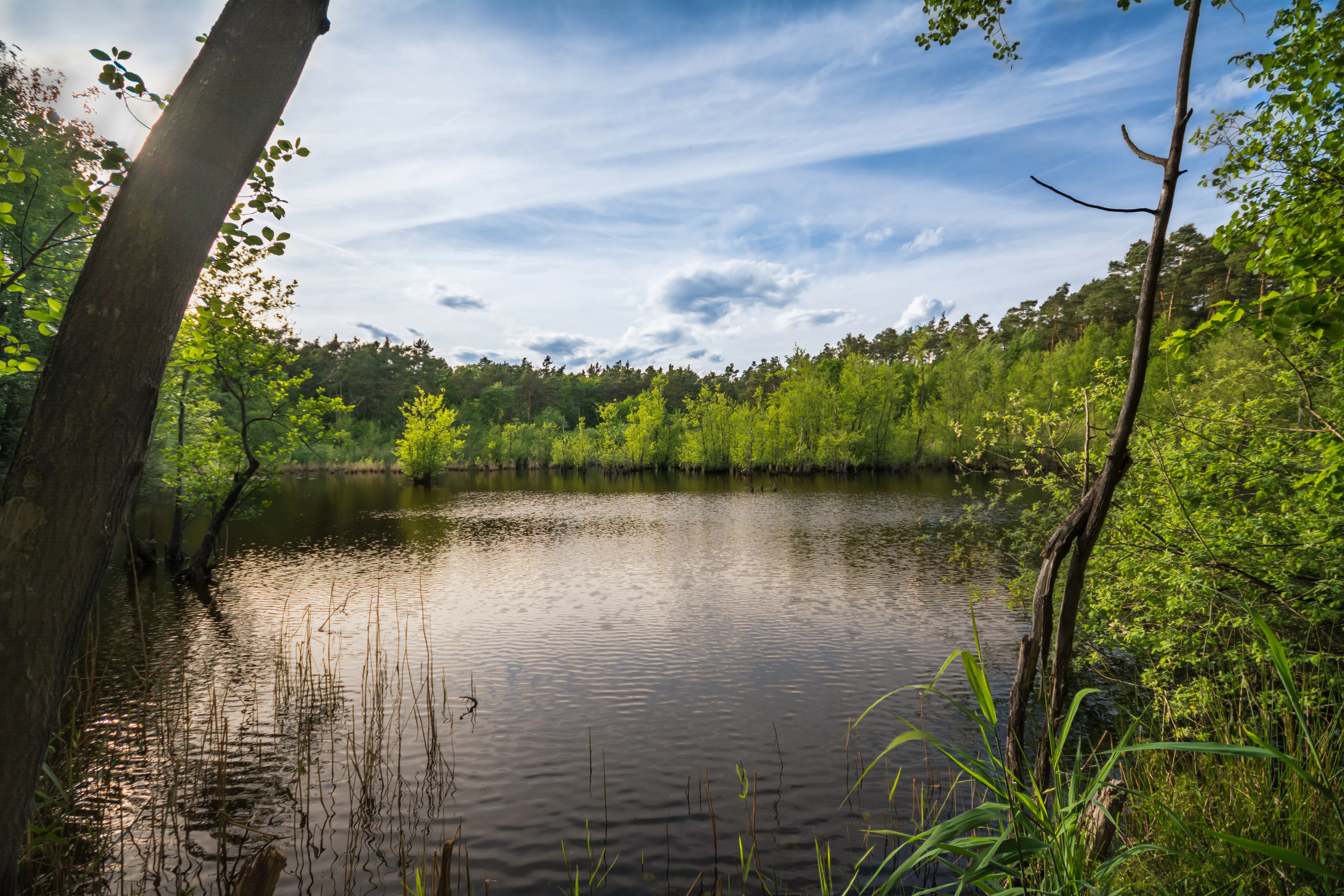
A tranquil pond surrounded by green trees and shrubs, with a reflection of the sky on the water surface.
A scenic view of the Rallenteich pond, surrounded by lush vegetation and forest.

Rallenteich von Eppertshausen history and protected-area timeline

The landscape that the Rallenteich von Eppertshausen protects was shaped by centuries of small-scale clay mining. From around the 15th century until 1947 or 1948, individual potter families dug their own subterranean clay workings, each withdrawing clay from its own "Tongewölbe." Over time the upper layers of the pits collapsed, the excavations filled with groundwater, and the abandoned surfaces were gradually colonized by marsh and aquatic vegetation. Some of the larger holes were later partly backfilled with fine sands from younger workings to the south, and at one stage the site was even discussed informally as a possible location for a refuse dump.

Concern about preserving the unexpected biological richness of the resulting biotopes emerged around 1970, and a sustained local campaign followed. These efforts culminated in formal designation as a Naturschutzgebiet by ordinance on 7 October 1976. Since then, the reserve has been managed as a small wetland habitat within the larger forest landscape between Eppertshausen and Messel, with one notable modern intervention: the construction in 2012 of amphibian tunnels beneath the Kreisstraße 180 to reduce roadkill of frogs, toads, and newts migrating to the pond for breeding between February and April.

Rallenteich von Eppertshausen landscape and geographic character

The reserve lies in a forested setting approximately 1.3 kilometers west of Eppertshausen, occupying a gently undulating terrain shaped by old clay workings. Its centerpiece is the Rallenteich itself, a small standing waterbody partly rimmed by reeds, with shallow margins grading into swamp woodland and, in the south, more open great sedge communities. Beyond the immediate wetland fringe, the terrain steps up into east and west-facing slopes where old, water-filled excavation hollows dot the woodland floor.

To the west and northwest the wooded slopes carry an acidic oak forest, with shallow pans still holding standing water at various times of year, while in the north a sandier ridge hosts self-sown and planted pines along with non-native spruce. The result is a tightly compressed landscape of pond, mire, oak woodland, and dry sandy ridge; just outside the reserve boundary, a larger pond belonging to a younger clay pit lies to the south, and the landscape protection area "Landkreis Offenbach" abuts the northern edge, extending the broader mosaic of woodland and wetland.
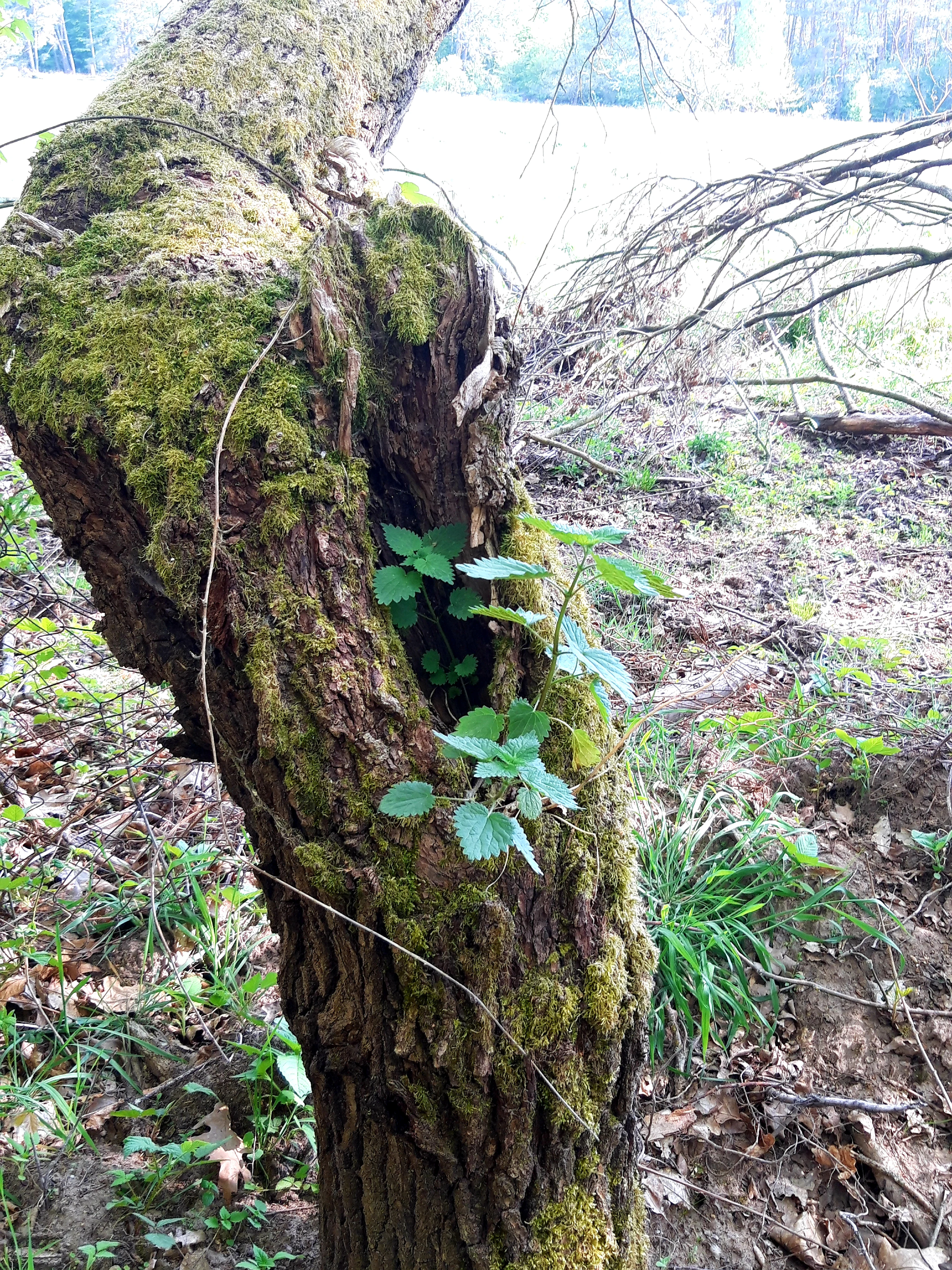
Close-up of a weathered, moss-covered tree trunk featuring a deep hollow that contains fresh green leaves, set in a wooded environment.
A mossy tree trunk with a hollow cavity hosting small green plants within the Rallenteich von Eppertshausen nature reserve.

Rallenteich von Eppertshausen ecosystems, habitats, and plant life

Ecologically, Rallenteich von Eppertshausen is defined by the unusually compressed mixture of habitat types it contains. The open water of the pond and its reed-fringed edges grade into species-rich wetland vegetation including greater pond sedge, a Cyperus-like sedge, yellow flag iris, celery-leaved buttercup, and water plantain. The boggy margins support club mosses, sphagnum mosses, and other mosses, while the wet woodland fringe carries a thin cover of swamp-forest trees.

Further out from the water, the acidic oak forest on former clay workings adds a distinctly different habitat layer, and the sandy ridge in the north introduces an even drier pine-dominated environment. This mosaic of pond, marsh, swamp woodland, oak forest, and sandy pine ridge within a few hundred meters produces a habitat richness that is rarely matched in reserves of comparable size.

Rallenteich von Eppertshausen wildlife and species highlights

The dense mosaic of habitats gives the reserve a strikingly high species count for such a small site. Around 40 bird species breed here, including firecrest, little grebe, Eurasian teal, garganey, common snipe, water rail, spotted crake, European turtle dove, middle spotted woodpecker, lesser spotted woodpecker, Eurasian wryneck, and red-backed shrike.

The site also supports ten amphibian species: common toad, common frog, agile frog, pool frog, moor frog, European tree frog, fire salamander, smooth newt, alpine newt, and great crested newt. Although the numbers of migrating amphibians have generally declined in recent decades, with counts dropping from nearly 4,800 animals in 1999 to roughly 410 in 2019 (extrapolated), the species mix remains an important feature of the reserve. In addition to birds and amphibians, the varied vegetation layers support a wide range of invertebrates and small mammals that depend on the wetland-forest mosaic.

Rallenteich von Eppertshausen conservation status and protection priorities

The principal conservation value of the Rallenteich von Eppertshausen lies in its function as a small but unusually rich refuge for wetland-dependent and forest-dependent wildlife in an otherwise densely settled part of southern Hesse. The site is classified internationally under the IUCN system as a Category IV Habitat/Species Management Area (WDPA ID 82362), a designation that recognizes managed intervention to support specific species and habitats rather than purely passive wilderness protection.

Conservation efforts have focused on preserving the habitat mosaic and reducing direct threats to animals using it. The 2012 construction of amphibian tunnels beneath the Kreisstraße 180 between Eppertshausen and Messel is the most visible management measure, designed specifically to mitigate the historically high road mortality of frogs, toads, and newts migrating toward the pond for breeding in late winter and spring. Continued monitoring of amphibian numbers, alongside the maintenance of the open-water and wetland vegetation through traditional reserve management, remains central to keeping the site ecologically viable in the face of long-term population declines.

Rallenteich von Eppertshausen cultural meaning and human context

The Rallenteich reserve reflects more than five centuries of human shaping of the local landscape. Beginning around the 15th century, successive generations of potter families in the Eppertshausen area mined the clay-rich ground for ceramic production, each family working its own pit or "Tongewölbe." This polycentric, family-scale extraction left behind not a single large quarry but a patchwork of small workings whose collapse and flooding created the very conditions that later became ecologically valuable. The site thus stands as a small-scale example of how traditional rural craft industries in Hesse left a legacy of post-industrial habitat that conservation can later inherit.

Top sights and standout views in Rallenteich von Eppertshausen

The reserve's core highlight is the sheer density of species packed into a 12-hectare mosaic: about 40 breeding bird species and 10 amphibian species share a single site that includes pond, reedbed, swamp woodland, great sedge fen, acidic oak forest, water-filled clay pits, and a sandy pine ridge.

A secondary highlight is the site's origin as a cluster of family-scale clay diggings abandoned in the late 1940s, illustrating how centuries of small-scale rural industry have produced a habitat of modern conservation value. The amphibian tunnels installed under the local road in 2012 add a more recent chapter, showing practical small-site conservation management in action.

Best time to visit Rallenteich von Eppertshausen

The reserve is most lively in spring, when the migration of frogs, toads, and newts to the pond between February and April offers the best chance to observe amphibian activity and to appreciate why the 2012 road tunnels were built. Late spring and early summer are also a strong period for birdwatching, as many of the roughly 40 breeding bird species are vocal and visible around the reed-fringed pond and along the oak-forest edges.

Midsummer and autumn are quieter but still rewarding for those interested in wetland vegetation, moss communities, and the contrast between the wet central habitat and the drier pine ridge in the north. Because the site is a protected area, visits should focus on observation from paths and the edges of the reserve rather than on entering sensitive zones.

Monthly climate preview

Long-term representative temperature and precipitation averages for Hesse

Rallenteich von Eppertshausen Climate Normals and Weather by Month

Representative coordinate records show measured monthly temperature and precipitation variations across the year at Rallenteich von Eppertshausen. Analyzing the complete twelve-month climatology profile provides deeper insight into long-term environmental patterns.
Annual mean10 °C
0 °C21 °C
Jan
Feb
Mar
Apr10°
May14°
Jun18°
Jul21°
Aug20°
Sep15°
Oct10°
Nov
Dec
Warmest month
July

20.6 °C

Coolest month
January

0.2 °C

Wettest month
July

2.2 mm/day

Driest month
April

1.4 mm/day

Park location guide

Geography guide, regional context, and park location map for Rallenteich von Eppertshausen

Rallenteich von Eppertshausen park geography, regions, and map view in Germany

Understand where Rallenteich von Eppertshausen sits in Germany through a broader geographic reading of the surrounding landscape, nearby location context, and its mapped position within the national park landscape.

How Rallenteich von Eppertshausen fits into Germany

Germany is a federal republic in Western and Central Europe with a population of over 83 million across sixteen constituent states. It is Europe's largest economy by nominal GDP and a major global exporter and importer. The capital is Berlin, and the country borders Denmark, Poland, Czech Republic, Austria, Switzerland, France, Luxembourg, Belgium, and the Netherlands.

Wider geography shaping Rallenteich von Eppertshausen in Germany

Germany is located in Western and Central Europe, spanning 357,022 km². It borders Denmark to the north, Poland and the Czech Republic to the east, Austria and Switzerland to the south, and France, Luxembourg, Belgium, and the Netherlands to the west. The country has coastlines on the Baltic Sea and North Sea to the north, with the Alps located in the southern region.

Map view of Rallenteich von Eppertshausen

Use this park location map to pinpoint Rallenteich von Eppertshausen in Germany, understand its exact geographic position, and read its mapped placement within the surrounding landscape more clearly.

Pigeon | © OpenStreetMap contributors

Location context for Rallenteich von Eppertshausen

Hesse

Visual reference for wetland habitats, swamp woodland, and former clay quarry terrain

Rallenteich von Eppertshausen Photos and Landscape Scenery

Photographic documentation reveals the compact wetland mosaic, standing ponds, and acidic oak forests defining the protected area. Visual exploration of the terrain clarifies how post-industrial clay workings evolved into a diverse wildlife refuge.

A tranquil pond surrounded by green trees and shrubs, with a reflection of the sky on the water surface.

A serene pond framed by trees and tall grasses at the Rallenteich von Eppertshausen nature reserve, with dense forest in the background.

Close-up of a weathered, moss-covered tree trunk featuring a deep hollow that contains fresh green leaves, set in a wooded environment.

Park atlas

Compare surrounding wetland reserves and regional conservation landscapes

Other Parks Like Rallenteich von Eppertshausen and Nearby Protected Areas

Browse protected areas near Rallenteich von Eppertshausen to compare similar wetland mosaics and forest habitats across the surrounding region. Extended park discovery reveals connected ecological zones and adjacent nature reserves sharing comparable post-industrial terrain.
Nature reserveHessen
About 0.9 km away#1 closest

West

Erlenwiesen bei Ober-Roden Nature Reserve: Landscape and Geography in Hessen, Germany

Protected riparian forest and wetland habitat mosaic

Erlenwiesen bei Ober-Roden is a specialized nature reserve in the Messeler Hügelland of Hessen, protecting a dense concentration of alder-ash floodplain forests, sedge swamps, and wet meadows. Spanning approximately 14 hectares, it remains a crucial example of lowland stream valley conservation and habitat management within the German landscape.

Area
0.143 km²
Established
1996
IUCN
IV
A soft watercolor painting of a winding stream through a green wetland with trees and distant hills in the background.
Nature reserveHessen
About 2 km away#2 closest

Southeast

Faulbruch von Münster Nature Reserve: Hessen Wetland and Forest Geography

Mapped protected landscapes in southern Germany.

Discover the geographic composition of Faulbruch von Münster, a protected nature reserve in Hessen. This area features a distinctive mix of alder swamp forest and wet meadows, providing a valuable habitat within the Rhine-Main region. Analyze the terrain, forest patches, and wetland boundaries through our detailed regional atlas.

Area
0.77 km²
Established
1985
IUCN
IV
A horizontal watercolor illustration depicting a soft, pastel-colored meadow with wildflowers in the foreground and a gentle forest line in the background against a white background.
Nature reserveLandkreis Darmstadt-Dieburg
About 2.5 km away#3 closest

West

Neuwiese von Messel Nature Reserve: Mapped Geography and Protected Landscape Context

Essential nature reserve located in Landkreis Darmstadt-Dieburg

Neuwiese von Messel consists of open meadow islands surrounded by mature deciduous forest, creating a representative forest-meadow mosaic in the Messeler Hügelland. This nature reserve functions as a vital conservation site for specialized plants and habitat types, protected within the European Natura 2000 network. Gain insight into its terrain, soil-based biodiversity, and the centuries-old traditional management that sustains this protected German landscape.

Area
1.072 km²
Established
1986
IUCN
IV
Relief
Lowland
Watercolor painting of a soft, hazy landscape featuring scattered trees, bushes, and rolling hills in shades of green and pink against a pale background.
Nature reserveHesse
About 3.2 km away#4 closest

South

Fohlenweide von Dieburg: Nature Reserve and Protected Landscape in Hesse, Germany

Mapping the wet meadow habitats and ecological boundaries of southern Hesse.

Located in the Darmstadt-Dieburg district, Fohlenweide von Dieburg is a refined example of a small-scale cultural landscape preserved for its high ecological value. The protected area features a unique mosaic of damp grasslands, forest margins, and riparian strips that support a range of wildlife. This site offers insight into regional conservation management in Central Europe.

Area
0.235 km²
Established
1989
IUCN
IV
Relief
Lowland
A watercolor painting of a flat, marshy landscape with soft green trees, grassy plains, and subtle pink tones against a white background.
Nature reserveHessen
About 4.5 km away#5 closest

North

Rodauwiesen bei Rollwald Nature Reserve: Protected Lowland Landscapes in Hessen

Mapping floodplain meadows and reed habitats in the Rodau valley

The Rodauwiesen bei Rollwald nature reserve protects a distinct 32-hectare stretch of lowland floodplain along the Rodau stream in Hessen. This site serves as a vital green refuge, featuring expansive open grassland and significant common reed stands that mirror the historic character of the Untermainebene. Use this geographic reference to study the area's protected boundaries, hydrological terrain, and surviving wet meadow ecosystems within a rapidly developing urban corridor.

Area
0.327 km²
Established
1999
IUCN
IV
Relief
Lowland
Nature reserveLandkreis Offenbach
About 4.5 km away#6 closest

Northeast

Niederrodener Lache: A Protected Nature Reserve in Landkreis Offenbach, Germany

Brook-side habitat mosaic and regional landscape geography

Niederrodener Lache encompasses 124 hectares of protected woodland and grassland in the Landkreis Offenbach district. Centered on the Lache brook, the reserve hosts a dense interweaving of alder-fringed streams and varied meadow types. Its landscape profile provides a vital refuge for threatened vegetation and wetland biotopes within the suburbanizing Rhine-Main metropolitan area.

Area
1.246 km²
Established
1986
IUCN
IV
A horizontal watercolor painting depicting a soft-focus landscape with rolling green hills, a marshy foreground with grasses, and light purple mountains in the distance.
Nature reserveHesse
About 4.7 km away#7 closest

South

Das große Hörmes bei Dieburg Nature Reserve: A Wetland Protected Area in Hesse

Mapped lowland wetland habitat in the Gersprenz district

This compact nature reserve in southern Hesse provides a essential sanctuary for wetland species, featuring a rare combination of reedbeds, sedge stands, and moist litter meadows. The area highlights the historical character of the Gersprenz lowlands through its protected hydrological network and open herbaceous habitat structure.

Area
0.136 km²
Established
1985
IUCN
IV
A soft watercolor illustration depicting a meadow landscape with a winding stream, distant hills, and foreground wildflowers.
Nature reserveHessen
About 4.8 km away#8 closest

Southeast

Die kleine Qualle von Hergershausen Nature Reserve and Protected Floodplain Landscapes

A preserved wetland fragment in the Hessen region

Die kleine Qualle von Hergershausen stands as a key protected area within the Gersprenz floodplain. This site offers a unique look at remnant wet meadow terrain, serving as an essential breeding and stopover ground for waterbirds in the Darmstadt-Dieburg district. Its geography provides a clear contrast to the surrounding agricultural fields, highlighting the impact of long-term conservation and habitat restoration efforts.

Area
0.27 km²
Established
1984
IUCN
IV

Common questions about visiting, size, designation, and location context for Rallenteich von Eppertshausen

Rallenteich von Eppertshausen FAQs for park facts, access, geography, and protected area context

Find quick answers about Rallenteich von Eppertshausen, including protected-area facts, park geography, trail and visitor context, and how the park fits into its surrounding country and regional landscape.
MoriAtlas Explorer

Continue Your Protected Areas Search Across the Global Atlas

Deepen your exploration by continuing the structured search for national parks and protected areas worldwide. Utilize the comprehensive filtering capabilities to compare different conservation landscapes and refine your understanding of global park geography. Discover more about the distribution and characteristics of protected natural areas.

Global natural geography