
Mori Atlas logo
Nature reserveRašeliniště U jezera – Cínovecké rašeliniště

Mapping the ecological boundaries and rare bog terrain of this Czech nature reserve.

Rašeliniště U jezera – Cínovecké rašeliniště: Protected Montane Peatlands in the Ore Mountains

Rašeliniště U jezera – Cínovecké rašeliniště represents a vital fragment of montane raised bog habitat situated along the high ridge of the Ore Mountains at roughly 860 meters. This nature reserve serves as an essential protected landscape within the Ústecký kraj, preserving specialized peatland vegetation and complex waterlogged terrain that has become rare in the surrounding mountain matrix. Through structured geographic observation, users can trace the extent of these peat-forming ecosystems and their transboundary connection to the broader Krušné hory landscape.

raised bogpeatlandvrchovištěKrušné horyOre Mountainsmountain mire
A flat, stylized illustration of a mountain valley at sunset. In the foreground, there are pink wildflowers and tall grasses. The midground features a clearing and dense green pine trees, leading up to steep rocky mountains in the background under a soft sunset sky.

Rašeliniště U jezera – Cínovecké rašeliniště

Nature reserve

Park overview

Structured park overview, official facts, and landscape profile for Rašeliniště U jezera, Cínovecké rašeliniště

Rašeliniště U jezera, Cínovecké rašeliniště park facts, protected area profile, and essential visitor context

Review the core facts for Rašeliniště U jezera, Cínovecké rašeliniště, including designation, size, terrain, visitor scale, habitats, and operating context in one park-focused overview.

About Rašeliniště U jezera, Cínovecké rašeliniště

Rašeliniště U jezera – Cínovecké rašeliniště lies along the upper reaches of the Krušné hory, the long mountain chain that forms much of the border between the Czech Republic and Saxony. The reserve covers a comparatively small, but ecologically dense, area of bog terrain near the settlements of Cínovec and Košťany in the Teplice District. Its placement high on the mountain ridge places it firmly within the cool, wet climatic zone that historically supported extensive peatland formation across central European highlands.

The reserve is an example of a vrchovištní rašeliniště, a classic raised bog driven primarily by rainfall rather than by groundwater or stream flow. Over centuries, the slow accumulation of partially decomposed Sphagnum and other bog vegetation built up a thick, dome-like peat body that isolates the surface from surrounding mineral soils. Within this acidic, nutrient-poor, and consistently saturated environment, a specialized community of plants has developed, including sundews, cotton grasses, cloudberries, and the bog cranberry, alongside relict shrubs such as wild rosemary that give these mires their distinctive open, heath-like character.

The ecological significance of the reserve extends beyond its botanical interest. Its raised bog acts as a long-term carbon store, a hydrological buffer that helps stabilize local runoff patterns, and a refuge for cold-adapted invertebrate, amphibian, and reptile species that have largely vanished from the surrounding transformed landscape. The bordering Ore Mountains were subjected to severe ecological damage during the twentieth century, particularly from industrial air pollution and extensive spruce monocultures that destroyed vast stretches of original peatland. Sites such as Cínovecké rašeliniště therefore carry disproportionate conservation weight as surviving reference points for the range's original montane character.

A notable feature of the reserve's setting is its position directly on the national border. Immediately across the frontier in Saxony lies the Georgenfelder Hochmoor, a comparable and ecologically connected peatland. Together, the two protected areas form a transboundary complex that helps maintain genetic and ecological continuity for bog-dependent species, even though national administration divides them. This international context adds an important layer to the reserve's identity and reinforces its role within broader European peatland conservation efforts.

Quick facts and research context for Rašeliniště U jezera, Cínovecké rašeliniště

Rašeliniště U jezera – Cínovecké rašeliniště is a Czech přírodní rezervace (nature reserve), classified at the national level under IUCN Category IV as a Habitat/Species Management Area. It lies in the Teplice District of the Ústecký kraj, north of the town of Košťany and near the village of Cínovec.

The reserve was established on 1 March 2001 by the former Okresní úřad Teplice and covers roughly 60 hectares. It sits at an elevation of approximately 863 to 873 meters above sea level, placing it among the highest-elevation protected peatland sites in the Czech part of the Krušné hory. Its ecological continuity with the German Georgenfelder Hochmoor gives it additional transboundary significance.

Protection and recognition

Examining documented terrestrial protection scope and international recognition sources

Rašeliniště U jezera – Cínovecké rašeliniště Protection Status and Natura 2000 Records

Records outline the terrestrial protection scope and verified Natura 2000 designation data for Rašeliniště U jezera – Cínovecké rašeliniště. Structured details clarify official recognition frameworks associated with this protected natural area.
Park context

Deeper park guide and search-rich context for Rašeliniště U jezera, Cínovecké rašeliniště

Rašeliniště U jezera, Cínovecké rašeliniště history, landscape, wildlife, and travel context

Explore Rašeliniště U jezera, Cínovecké rašeliniště through its history, landscape character, ecosystems, wildlife, conservation priorities, cultural context, and seasonal travel timing in a structured park guide built for atlas discovery and search intent.

Why Rašeliniště U jezera, Cínovecké rašeliniště stands out

The reserve is best known for preserving a fragment of true raised bog, or vrchoviště, in the Czech Ore Mountains. Raised bogs are nutrient-poor, rain-fed peatlands where Sphagnum mosses and bog shrubs accumulate deep layers of peat over centuries, and they have become one of the most endangered habitat types in central Europe. Cínovecké rašeliniště represents exactly this habitat type at an unusually high elevation for the region, harboring bog-pool flora such as bog cranberry and wild rosemary alongside orchids, reptiles, and amphibians adapted to cool, acidic, waterlogged conditions. The site is frequently cited as one of the few remaining functional examples of the original montane peatland character that once spanned much of the upper Krušné hory ridge.
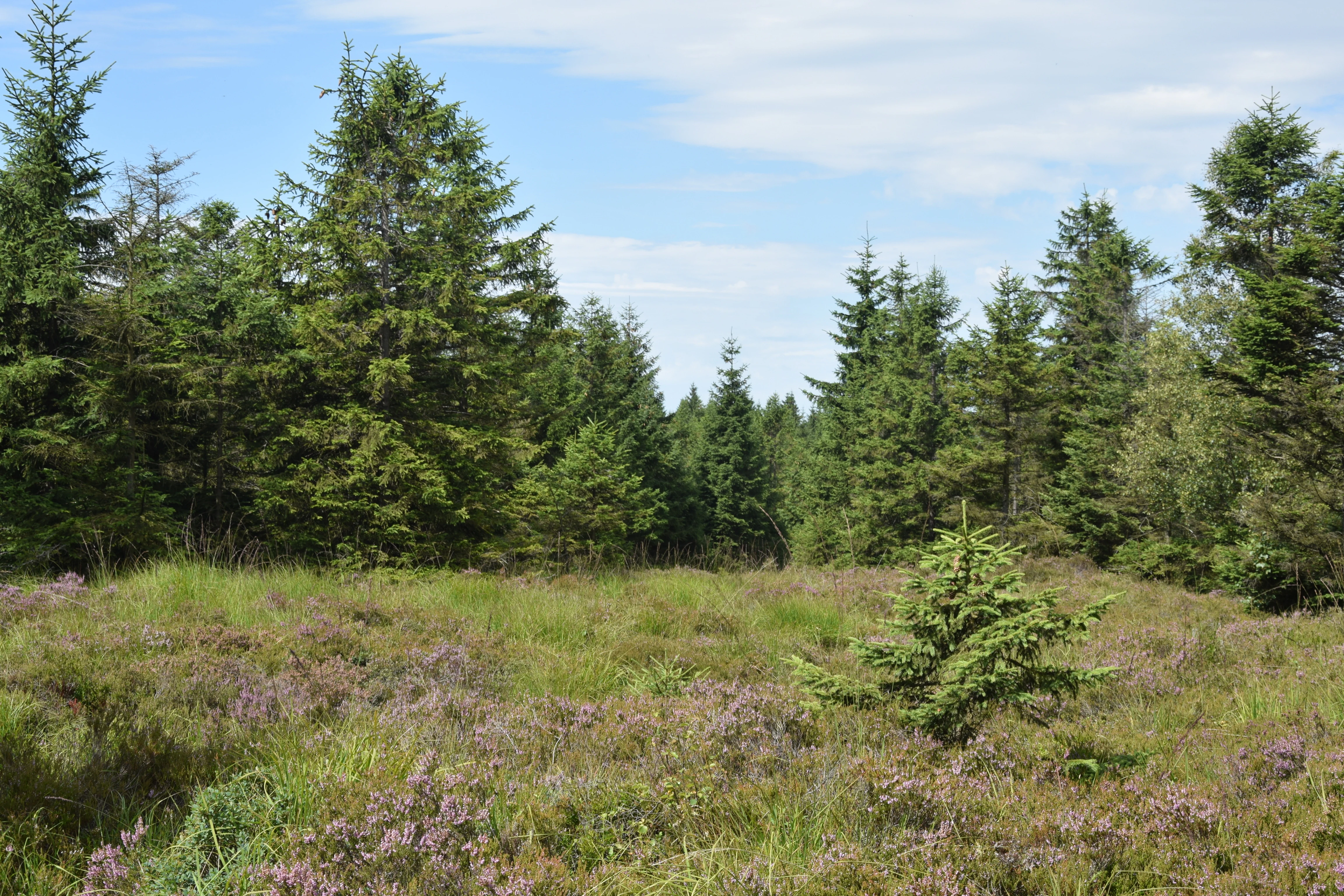
A clearing filled with purple heather and small green shrubs, bordered by a dense evergreen forest under a partly cloudy sky.
A clearing with heather in the Rašeliniště U jezera, Cínovecké rašeliniště Nature Reserve.

Rašeliniště U jezera, Cínovecké rašeliniště history and protected-area timeline

The site entered formal protection relatively recently. Rašeliniště U jezera – Cínovecké rašeliniště was declared a přírodní rezervace, or nature reserve, on 1 March 2001 by the Okresní úřad Teplice, the district authority that handled nature conservation duties at the time. The original reservation used the simpler name Cínovecké rašeliniště; the expanded combined name was adopted later to reflect the inclusion of the adjacent 'U jezera' peatland.

The late date of formal designation reflects a broader pattern in the Krušné hory, where extensive peatlands persisted in relatively untouched condition into the late twentieth century but were already heavily degraded by the time conservation frameworks expanded. The reserve's establishment was part of a wider effort across both sides of the Czech-German border to safeguard the remaining functional remnants of the range's original raised bog ecosystems before further losses occurred.

Rašeliniště U jezera, Cínovecké rašeliniště landscape and geographic character

The landscape of the reserve is defined by a flat to gently undulating plateau along the high ridge of the Ore Mountains, at roughly 860 to 870 meters above sea level. The terrain is waterlogged and poorly drained, dominated by deep peat deposits accumulated over many centuries. Open bog surfaces alternate with bog pools, hummocks, and low ridges of drier peat, giving the site a quietly varied microtopography.

Surrounding the bog proper, the wider Ore Mountains landscape is a mixture of surviving peatland fragments, regenerating bog margins, and extensive coniferous forest that has replaced much of the original montane vegetation outside the reserve. At the reserve's edges, transitions between open mire and adjacent spruce forest create striking ecological boundaries that highlight how isolated the protected core has become within the broader mountain matrix.

Rašeliniště U jezera, Cínovecké rašeliniště ecosystems, habitats, and plant life

The reserve belongs to the vrchovištní rašeliniště, or raised bog, ecosystem type, one of the most ecologically specialized and most threatened habitat categories in the Czech Republic. Raised bogs are ombrotrophic, meaning they derive their water and nutrients almost exclusively from precipitation, and they develop the acidic, low-nutrient conditions that select for highly specialized vegetation.

Dominant ecological processes include continuous Sphagnum growth, slow peat accumulation, and the maintenance of a stable waterlogged surface that resists tree encroachment. Where the bog surface has been disturbed or dried at the margins, successional change toward scrub and woodland becomes a major ecological pressure, and managing hydrological stability is among the central conservation concerns for the site. The reserve thus represents not only a static biological snapshot but also an active ecological system whose continued existence depends on intact hydrology.

Rašeliniště U jezera, Cínovecké rašeliniště wildlife and species highlights

The wildlife profile of Cínovecké rašeliniště reflects the cold, acidic, open-mire conditions typical of central European mountain raised bogs. Among reptiles, the common European adder (Vipera berus) and the viviparous lizard (Zootoca vivipara) are characteristic species, well adapted to the cool microclimate and open vegetation structure.

Invertebrate communities of Sphagnum mires, including dragonflies, bog-specialist moths, and various Diptera, form the unseen backbone of the food web. Amphibians commonly associated with bog pools and bog-margin ponds also use the reserve during their breeding season. Although the visible fauna is relatively inconspicuous, the site's value for these cold-adapted specialists is heightened by the heavily transformed state of the surrounding mountains.

Rašeliniště U jezera, Cínovecké rašeliniště conservation status and protection priorities

Cínovecké rašeliniště represents one of the threatened ecosystem types of the Krušné hory, a mountain range whose original montane character was severely disrupted by industrial air pollution, large-scale spruce afforestation, drainage, and peat extraction during the twentieth century. Protecting a functioning fragment of raised bog in this context carries conservation significance well beyond the site's modest 60-hectare footprint.

The reserve is managed as a habitat-focused protected area, with the primary goal of maintaining the peat-forming hydrology and the specialist species that depend on it. The cross-border connection with the Georgenfelder Hochmoor in Saxony reinforces its conservation value, allowing the two sites jointly to safeguard a coherent ecological unit that would otherwise be split by the national boundary. The site is also part of the wider effort, visible across the Czech Republic's network of přírodní rezervace, to preserve representative examples of every major native habitat type before further attrition occurs.

Top sights and standout views in Rašeliniště U jezera, Cínovecké rašeliniště

Among the reserve's standout features are its status as a true vrchovištní rašeliniště on the Czech side of the Ore Mountains, its position at the unusually high elevation of roughly 860 to 870 meters, and its ecological continuity with the German Georgenfelder Hochmoor. The combination of protected Sphagnum bog, bog-pool vegetation, and relict bog shrubs such as wild rosemary and bog cranberry provides a dense concentration of conservation value within a very compact area.

The reserve's late-twentieth-century designation on 1 March 2001 also marks it as part of a generation of Krušné hory protected areas established in response to the long history of ecological pressure on the range.

Best time to visit Rašeliniště U jezera, Cínovecké rašeliniště

The reserve sits in a high-elevation montane setting where the bog ecosystem remains sensitive in every season. Late spring and early summer bring the most visible botanical activity, including flowering of characteristic bog species and the appearance of orchids such as the spotted orchid. Summer offers the best overall conditions for observing the open mire landscape, while autumn highlights the seasonal coloration of bog shrubs. Winter visits are generally less rewarding ecologically, when snow cover may obscure the site and access through the surrounding highland terrain can be considerably more difficult; the cool, waterlogged microclimate persists year-round but is less visually expressive in winter.

Monthly climate preview

Long-term temperature ranges and monthly precipitation averages across representative coordinates

Rašeliniště U jezera – Cínovecké rašeliniště Climate Normals and Annual Weather Patterns

Representative coordinate records show mean monthly temperatures ranging from sub-zero winter minimums to warm summer maximums alongside steady precipitation distributions. Detailed monthly climate normals provide complete statistical context for long-term meteorological tracking across the protected area.
Annual mean8 °C
-3 °C19 °C
Jan-3°
Feb-1°
Mar
Apr
May13°
Jun17°
Jul19°
Aug18°
Sep13°
Oct
Nov
Dec-2°
Warmest month
July

18.7 °C

Coolest month
January

-2.6 °C

Wettest month
July

2.5 mm/day

Driest month
February

1.1 mm/day

Park location guide

Geography guide, regional context, and park location map for Rašeliniště U jezera, Cínovecké rašeliniště

Rašeliniště U jezera, Cínovecké rašeliniště park geography, regions, and map view in Czechia

Understand where Rašeliniště U jezera, Cínovecké rašeliniště sits in Czechia through a broader geographic reading of the surrounding landscape, nearby location context, and its mapped position within the national park landscape.

How Rašeliniště U jezera, Cínovecké rašeliniště fits into Czechia

Czech Republic is a landlocked Central European country with a population of approximately 10.9 million people. The nation was established as an independent state on January 1, 1993, following the dissolution of Czechoslovakia. Its capital and largest city is Prague, with other major urban centers including Brno, Ostrava, Plzeň, and Liberec.

Wider geography shaping Rašeliniště U jezera, Cínovecké rašeliniště in Czechia

The Czech Republic is a landlocked country in Central Europe. It is bordered by Germany to the west, Austria to the south, Poland to the northeast, and Slovakia to the southeast. The landscape is predominantly hilly, with the territory covering 78,871 square kilometers.

Map view of Rašeliniště U jezera, Cínovecké rašeliniště

Use this park location map to pinpoint Rašeliniště U jezera, Cínovecké rašeliniště in Czechia, understand its exact geographic position, and read its mapped placement within the surrounding landscape more clearly.

Pigeon | © OpenStreetMap contributors

Location context for Rašeliniště U jezera, Cínovecké rašeliniště

Ústecký kraj
Recorded earthquake history

Explore Historical Earthquake Records Near Rašeliniště U jezera – Cínovecké rašeliniště

MoriAtlas maintains a detailed catalogue of historical seismic activity associated with the location of Rašeliniště U jezera – Cínovecké rašeliniště. Open this record to view mapped epicentres, event dates, and magnitude data for events occurring in the vicinity of this significant Ore Mountains protected area.

Rašeliniště U jezera – Cínovecké rašeliniště Earthquake History

Catalogued events

14 events

Strongest magnitude

Magnitude 3.8

Most recent event

Nov 15, 2004

This history includes earthquakes recorded inside the park or within 50 km of its borders

Visual reference of raised bog habitats and mountain mire terrain in the Ore Mountains

Rašeliniště U jezera – Cínovecké rašeliniště Photos and Landscape Scenery

Visual documentation captures the rare raised bog habitats and waterlogged terrain preserved within Rašeliniště U jezera – Cínovecké rašeliniště. Detailed photography reveals the distinctive montane peatland scenery and delicate Sphagnum vegetation characteristic of the Ore Mountains ridge.

A clearing filled with purple heather and small green shrubs, bordered by a dense evergreen forest under a partly cloudy sky.

Park atlas

Compare nearby mountain reserves and regional protected landscapes across the Ore Mountains.

Parks Near Rašeliniště U jezera – Cínovecké rašeliniště and Surrounding Protected Areas

Browsing other protected areas near Rašeliniště U jezera – Cínovecké rašeliniště reveals the broader ecological context of the Krušné hory mountain range. Continuing into adjacent regional reserves helps place rare peatland habitats within a wider cross-border conservation network.
Watercolor painting of a peat bog with a small meandering stream, scattered deadwood, and a distant mountain range under a pale sky.
Nature reserveSachsen
Park boundaries overlap#1 closest

Northeast

Georgenfelder Hochmoor Nature Reserve: A Protected Highland Bog in the Ore Mountains

Examining the geography and mapped peatland terrain in the Sachsen region

Georgenfelder Hochmoor is a distinct ridge-top raised bog located on the high plateau of the Osterzgebirge. This protected area maintains a significant ten-thousand-year peat profile and plays a vital role in the watershed divide of the Ore Mountains, offering a clear example of modern transboundary conservation and mountain moorland development.

Area
0.135 km²
Established
1961
IUCN
IV
Visitors
17.5K annual
A wide watercolor painting depicting a green landscape with rolling hills, scattered trees, and a pale sky.
Nature reserveSaxony
About 4.2 km away#2 closest

Northeast

Bergwiesen im Osterzgebirge Nature Reserve: Saxony Regional Protected Area Atlas

Mapping cultural montane meadow landscapes and stone-strip field systems.

Bergwiesen im Osterzgebirge protects an extensive network of open-land habitats across the eastern Ore Mountains of Saxony. The area is defined by its complex mosaic of mountain meadows, mat-grass swards, and remnants of bog systems. This record examines the geographic extent of these preserved lands and their role in maintaining traditional agricultural heritage within the regional mountain topography.

Established
1999
Relief
Mountain
Climate
Temperate
Scope
Terrestrial
Watercolor painting of a panoramic mountain landscape with rolling green hills, patches of forest, and distant peaks under a soft sky.
Nature reserveSaxony
About 5.1 km away#3 closest

North

Geisingberg Nature Reserve: A Volcanic Basalt Peak in the Eastern Ore Mountains of Saxony

Exploration of protected mountain terrain and volcanic geology

Geisingberg serves as a rare volcanic Quellkuppe rising above the Saxon mining landscapes of Altenberg. The nature reserve protects 300 hectares of high-altitude bogs, species-rich meadows, and historic forest clearings. Gain a deeper understanding of this mountain through detailed mapped terrain, topographic features, and long-standing protected-area status within the Ore Mountains.

Area
3 km²
Established
1960
Relief
Mountain
Climate
Temperate
Nature reserveSächsische Schweiz-Osterzgebirge
6.2 km away#4 closest

North

Weicholdswald Nature Reserve: Mapped Protected Landscapes of the Eastern Ore Mountains

A preserved beech forest enclave within the Sächsische Schweiz-Osterzgebirge

Weicholdswald stands as a primary nature reserve in the Sächsische Schweiz-Osterzgebirge district, known for its 160-year-old beech trees and extensive deadwood habitats. This protected area provides a rare look at near-natural forest ecosystems that have remained free from historic clear-cutting or coniferous monocultures, maintaining rich biodiversity across its streams and granitic slopes.

Area
1.037 km²
Established
1961
IUCN
IV
Nature reserveSachsen
7.7 km away#5 closest

Northwest

Gimmlitztal Nature Reserve in the Ore Mountains: Mapped Protected Landscapes

Exploring the stream valley geography of Saxony, Germany.

Gimmlitztal is a significant nature reserve in the German state of Saxony that protects the unique hydrology and biodiversity of the Gimmlitz stream corridor. The terrain includes forested slopes and traditional meadow patches, reflecting a long history of human interaction with the Ore Mountain environment. This reserve functions as a continuous green ribbon for regional habitat preservation.

Area
2.578 km²
Established
2015
IUCN
IV
A horizontal watercolor painting showing rolling green hills in the distance and colorful, stylized vegetation in the foreground.
Nature reserveÚstí nad Labem Region
About 16 km away#6 closest

Southeast

Rač Nature Reserve: Volcanic Slopes and Protected Habitats in Ústí nad Labem

Geomorphology and ecological succession in the České středohoří range

Rač Nature Reserve is a landmark for volcanic ecology, preserving a mosaic of trachyte rock formations and open grassland on the slopes of Hradiště u Habří. This protected area serves as a vital refuge for rare steppe-like flora and a high concentration of thermophilic insect species, offering a concentrated look at natural land recovery and geological history in northern Bohemia.

Area
0.154 km²
Established
1953
IUCN
IV
Relief
Mountain
A soft watercolor illustration of a bog landscape with a dark central pool, surrounding marsh vegetation, and distant pale hills.
Nature reserveÚstecký kraj
About 21 km away#7 closest

Northeast

Rájecká rašeliniště Nature Reserve: Protected Peatland and Sandstone Geography in Ústecký kraj

Geographic atlas and protected area landscape summary

Rájecká rašeliniště serves as a critical study in landscape ecology, featuring rare peat-forming vegetation located within the high-relief sandstone formations of the Ústecký kraj. This protected nature reserve provides a unique look at how specialized bog communities thrive despite the porous, water-draining characteristics of the local sandstone terrain, highlighting the site's importance within the Czech conservation landscape.

Area
0.017 km²
Established
2004
IUCN
IV
Water
Major water bodies
A watercolor illustration depicting rolling, soft hills and green vegetation with distant, faded mountains in the background, set against a plain white background.
Nature reserveGermany
About 26 km away#8 closest

North

Spargründe bei Dohna: Nature Reserve and Protected Valley Landscapes in Germany

Examining the crystalline ravines and forest ecosystems of the Saxon landscape

Spargründe bei Dohna stands as a distinct nature reserve at the northern margin of the Elbtalschiefergebirge. The site encompasses narrow, steeply-sided valleys carved into Dohna Granodiorite, creating a rugged terrain of rocky ridges and shaded deciduous woodland. This geographic overview examines the boundaries and natural features of the reserve, highlighting its role within the wider Müglitztal protected area network.

Area
0.373 km²
Relief
Upland
Climate
Temperate
Access
Easy access

Common questions about visiting, size, designation, and location context for Rašeliniště U jezera, Cínovecké rašeliniště

Rašeliniště U jezera, Cínovecké rašeliniště FAQs for park facts, access, geography, and protected area context

Find quick answers about Rašeliniště U jezera, Cínovecké rašeliniště, including protected-area facts, park geography, trail and visitor context, and how the park fits into its surrounding country and regional landscape.
MoriAtlas Explorer

Continue Your Protected Areas Search Across the Global Atlas

Deepen your exploration by continuing the structured search for national parks and protected areas worldwide. Utilize the comprehensive filtering capabilities to compare different conservation landscapes and refine your understanding of global park geography. Discover more about the distribution and characteristics of protected natural areas.

Global natural geography