
Mori Atlas logo
Natural monumentRasuveň

Understanding the mapped terrain and upland woodland conservation of this Czech monument

Rasuveň Natural Monument: Protected Forest Geography within the Czech Vysočina Region

(Přírodní památka Rasuveň)

Rasuveň serves as a vital protected refuge within the Czech-Moravian Highlands, where it preserves a fragment of native fir-beech forest landscape. Situated in the Vysočina Region near Bory, this natural monument offers clear insight into the original upland vegetation patterns of Central Europe. The site functions as a reference area for ecologists and naturalists interested in the region's historical woodland composition and its rolling, crystalline-based topography.

fir-beech forestupland forestmixed woodlandprotected forestnature monumentCzech highlands
A digital illustration of a forested mountain scene with a tall waterfall cascading down a cliff into a river, rendered in a soft, colorful, flat-design style.

Rasuveň

Natural monument

Park overview

Structured park overview, official facts, and landscape profile for Rasuveň

Rasuveň park facts, protected area profile, and essential visitor context

Review the core facts for Rasuveň, including designation, size, terrain, visitor scale, habitats, and operating context in one park-focused overview.

About Rasuveň

Rasuveň occupies a modest footprint on the forested uplands of the Vysočina Region, where the landscape is shaped by long ridges, gentle valleys, and a mosaic of woodland and farmland that has been altered over centuries of settlement. The reserve's importance lies in the fact that, amid this heavily worked environment, it preserves a stand of trees that still resembles the forest cover that once dominated the local elevation band.

The forest at Rasuveň belongs to the fir-beech vegetation zone, an altitudinal belt in Central European forest classification characterized by the natural coexistence of European beech and silver fir along with other broadleaf and coniferous companions. This zone once formed a major share of the woodland across the Czech-Moravian Highlands, but centuries of logging, grazing pressure, conifer planting, and changing land use have replaced most of these stands with simpler, often spruce-dominated forests. Rasuveň therefore functions as a living reference site, providing ecologists and foresters with a relatively undisturbed picture of what the local natural forest should look like.

Although the reserve is small, the surrounding protective buffer zone extends its practical influence and reduces the impact of edge effects, forestry operations, and recreational pressure on the core stand. Together with other protected sites in the district of Žďár nad Sázavou, Rasuveň contributes to a regional network of small reserves that collectively maintain biodiversity, structural complexity, and genetic resources for native tree species. For visitors, the site offers an accessible but quiet introduction to the woodland character of the Czech-Moravian Highlands, where forest, pasture, and small rural villages form a closely interwoven whole.

Quick facts and research context for Rasuveň

Rasuveň is a nature monument (přírodní památka) of roughly 21 hectares in the Vysočina Region of the Czech Republic, situated on the cadastral area of Dolní Bory near the village of Bory. The site sits at elevations between approximately 530 and 580 meters and was officially declared a protected area on 1 May 1989 by the Regional Authority of the Vysočina Region. It is classified as an IUCN Category IV protected area, recognizing its role in conserving a specific habitat and the species associated with it. The core purpose of protection is to preserve a remnant of forest with the natural species composition of the fir-beech vegetation zone, and a protective buffer zone surrounds the main reserve to safeguard its integrity.

Protection and recognition

Documented terrestrial conservation scope and recognition history

Rasuveň Protection Status and Official Designation Record

Rasuveň holds a recorded terrestrial protection scope within the global atlas database. Official records compile verified designation status and management framework details for accurate geographic reference.

Protection details

Protection scope
Terrestrial
Transboundary protection
No
Park context

Deeper park guide and search-rich context for Rasuveň

Rasuveň history, landscape, wildlife, and travel context

Explore Rasuveň through its history, landscape character, ecosystems, wildlife, conservation priorities, cultural context, and seasonal travel timing in a structured park guide built for atlas discovery and search intent.

Why Rasuveň stands out

Rasuveň is best known for safeguarding a surviving fragment of natural fir-beech forest in an upland landscape where this vegetation type has become fragmented and degraded. Its profile is defined less by dramatic scenery than by its value as a reference example of the original forest composition of the fir-beech altitudinal zone in the Czech-Moravian Highlands.
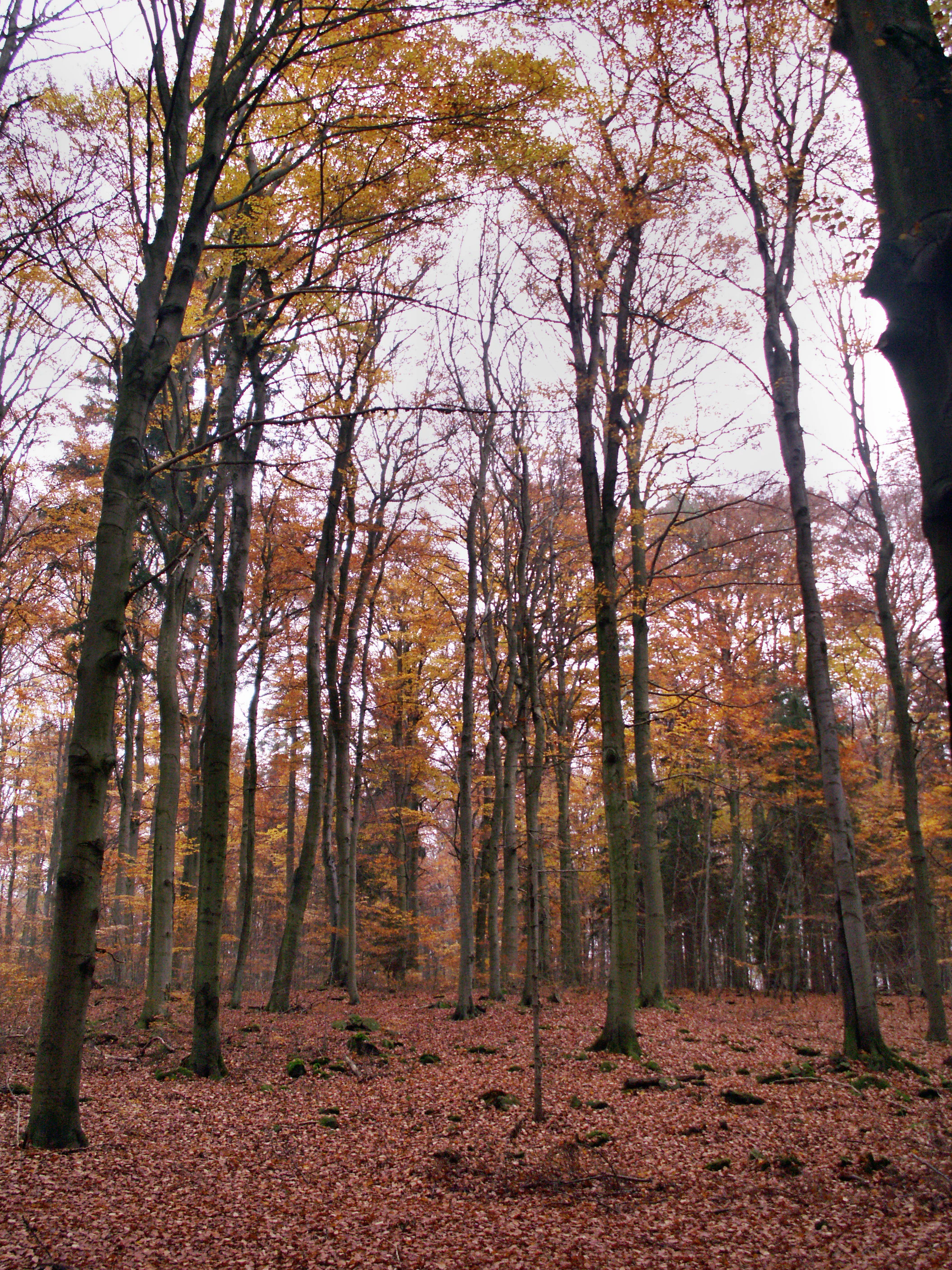
A view looking into a deciduous forest during autumn, with tall, slender tree trunks and a thick carpet of fallen brown leaves on the forest floor.
Autumn foliage in the deciduous forest of Rasuveň Natural Monument.

Rasuveň history and protected-area timeline

Rasuveň was established as a protected area on 1 May 1989, when the Regional Authority of the Vysočina Region issued the formal declaration creating the nature monument. The timing reflects a broader wave of small-scale nature conservation actions across the Czech lands during the late 1980s, when increasing awareness of habitat loss prompted the formal recognition of surviving fragments of natural vegetation.

The site was not created around a newly introduced or restored habitat; instead, it was designated to protect a forest stand that had already retained much of its natural composition. As the surrounding landscape was progressively modified by forestry and agricultural use, the value of this unaltered remnant became more pronounced, justifying its inclusion in the regional system of protected areas. A protective buffer zone was established alongside the core area to shield the forest from direct external disturbances and to limit activities that could alter its structure. Since its designation, the reserve has been administered within the framework of Czech nature protection, with management focused on maintaining the integrity of the fir-beech forest rather than on large-scale restoration work.

Rasuveň landscape and geographic character

Rasuveň lies in the rolling terrain typical of the Czech-Moravian Highlands, an upland region where long ridges, shallow valleys, and broad interfluves shape a gently undulating topography. Elevations at the site range between about 530 and 580 meters above sea level, placing it firmly within the mid-elevation forest belt rather than in mountain or lowland terrain.

The local geomorphology reflects the old, worn-down landscape of the Bohemian-Moravian Massif, where hard, often crystalline bedrock produces acidic, well-drained soils. These conditions have long favored mixed broadleaf and coniferous forest, and the surrounding region retains a patchwork of woodland, meadows, and small agricultural fields. Near Rasuveň, the forest occupies a continuous block of terrain rather than appearing as scattered patches, giving the protected area a sense of enclosure and quiet typical of mature Central European woodland. The nearby landscape includes the small villages of Krásněves and Dolní Bory, as well as broader connections to the settlements of Sklené nad Oslavou and Netín through regional hiking trails.

Rasuveň ecosystems, habitats, and plant life

Ecologically, Rasuveň represents a fragment of the fir-beech vegetation zone, an altitudinal band defined by the natural mixture of European beech and silver fir, often accompanied by spruce, Scots pine, and various broadleaf species such as oak, maple, and ash depending on local soil conditions. This zone, once widespread across the uplands of central Europe, has shrunk dramatically due to centuries of forest management, with conifer monocultures and timber-oriented silviculture replacing much of the original mixed cover.

The forest at Rasuveň is therefore significant because it preserves a more natural distribution of tree species, age classes, and structural layers, including the understory vegetation typical of mature Central European beech and fir forests. Retaining such complexity matters for soil processes, microclimate stability, and the broad habitat mosaic that supports forest-dwelling fauna. Even though the protected area is small, it functions ecologically as a refuge stand, allowing species that depend on old-growth characteristics, deadwood, and undisturbed canopy to persist in an otherwise modified regional forest landscape.

Rasuveň wildlife and species highlights

Because Rasuveň is a forest reserve, its wildlife is shaped primarily by woodland habitat rather than by open or aquatic environments. The mature canopy and multilayered structure typical of a natural fir-beech stand provide habitat for forest-dwelling birds, small mammals, and a range of invertebrates associated with decaying wood and old trees.

Typical species groups that benefit from such habitat conditions include forest passerines like thrushes, tits, and warblers, as well as woodpeckers that depend on old or decaying trees. Among mammals, the forest can support typical Central European woodland species such as roe deer, red squirrels, and various small mustelids, while the broader regional landscape hosts larger species like red deer and wild boar that may move through the area. Although the reserve does not host highly charismatic or rare megafauna, its ecological value lies in maintaining the structural conditions that allow typical forest communities to thrive in an otherwise simplified landscape.

Rasuveň conservation status and protection priorities

From a conservation standpoint, Rasuveň is most valuable as a reference site for the natural state of the fir-beech forest zone in the Vysočina Region. By protecting a relatively unaltered stand of trees, it safeguards genetic resources, structural diversity, and ecological processes that have largely disappeared from the surrounding managed forests. This makes the site an important baseline for monitoring long-term changes in forest composition and climate response.

The protected area is classified under IUCN Category IV, a category that emphasizes the conservation of specific species or habitats through active management intervention when needed. The designation of an outer protective buffer zone further strengthens this role by limiting damaging activities at the edges of the reserve and preserving the connectivity between the core forest and the wider landscape. As part of the network of protected sites in the Žďár nad Sázavou district, Rasuveň contributes to broader regional efforts to maintain biodiversity, protect native tree species, and retain examples of the original forest character of the Czech-Moravian Highlands.

Rasuveň cultural meaning and human context

Rasuveň sits within a landscape long shaped by rural settlement, forestry, and small-scale agriculture, typical of the Czech-Moravian borderlands. The nearby villages of Bory, Dolní Bory, and Krásněves reflect the region's pattern of dispersed hamlets and local communities whose livelihoods have historically depended on the surrounding forests and fields. While the reserve itself is primarily valued for its natural heritage, its setting within this traditional rural landscape gives it a broader cultural context, where woodland conservation and regional identity are closely intertwined. The presence of linked hiking trails to nearby Netín and Sklené nad Oslavou also connects the reserve to the network of footpaths historically used by local residents and now serving recreational visitors exploring the highland countryside.

Top sights and standout views in Rasuveň

Rasuveň stands out as a compact but ecologically meaningful refuge of natural fir-beech forest in the Czech-Moravian Highlands, a habitat type that has been largely replaced by managed conifer stands elsewhere in the region. Its protected status since 1989, combined with a designated buffer zone, gives it a clear conservation identity and an established role in the regional network of nature monuments. For forest ecologists, hikers, and naturalists interested in the original upland woodland character of central Europe, the reserve offers an accessible and authentic example of this vegetation zone in a setting of quiet rural landscapes and traditional villages.

Best time to visit Rasuveň

Rasuveň can be visited throughout much of the year, as it is a low-elevation forest rather than a high-mountain site. Late spring and early summer are particularly rewarding because the broadleaf component of the fir-beech forest is in full leaf and the understory vegetation is active, producing a rich sense of forest canopy and layered greenery. Early autumn brings strong color in the broadleaf trees and a more open feel beneath the canopy, while winter visits offer a quieter atmosphere and clearer views into the structure of the bare deciduous trees alongside the evergreen firs. Because the site is small and the trails pass near its edge rather than through its core, visitors will experience the reserve most fully by walking slowly along the marked paths and combining the visit with exploration of the surrounding countryside and nearby villages.

Monthly climate preview

Long-term temperature and precipitation patterns across twelve months for Rasuven in the Vysocina Region

Rasuven Climate Normals and Measured Weather by Month

Historical climate records from 1991 to 2000 trace the measured annual temperature and precipitation rhythm across representative coordinates in Rasuven. Exploring the complete monthly profile provides detailed context on long-term weather variations and baseline environmental conditions.
Annual mean7 °C
-4 °C18 °C
Jan-4°
Feb-2°
Mar
Apr
May12°
Jun16°
Jul18°
Aug18°
Sep13°
Oct
Nov
Dec-3°
Warmest month
July

18.5 °C

Coolest month
January

-3.8 °C

Wettest month
July

2.8 mm/day

Driest month
February

1.2 mm/day

Park location guide

Geography guide, regional context, and park location map for Rasuveň

Rasuveň park geography, regions, and map view in Czechia

Understand where Rasuveň sits in Czechia through a broader geographic reading of the surrounding landscape, nearby location context, and its mapped position within the national park landscape.

How Rasuveň fits into Czechia

Czech Republic is a landlocked Central European country with a population of approximately 10.9 million people. The nation was established as an independent state on January 1, 1993, following the dissolution of Czechoslovakia. Its capital and largest city is Prague, with other major urban centers including Brno, Ostrava, Plzeň, and Liberec.

Wider geography shaping Rasuveň in Czechia

The Czech Republic is a landlocked country in Central Europe. It is bordered by Germany to the west, Austria to the south, Poland to the northeast, and Slovakia to the southeast. The landscape is predominantly hilly, with the territory covering 78,871 square kilometers.

Map view of Rasuveň

Use this park location map to pinpoint Rasuveň in Czechia, understand its exact geographic position, and read its mapped placement within the surrounding landscape more clearly.

Pigeon | © OpenStreetMap contributors

Location context for Rasuveň

Vysočina Region

Examine the upland terrain, mixed canopy structure, and natural habitat character of the reserve.

Rasuveň Photos and Landscape Scenery: Visualizing the Protected Forest Environment

Visual documentation reveals the dense canopy structure and rolling upland terrain that define the protected forest environment at Rasuveň. Photographic records provide clear insight into the surviving fir-beech vegetation zone and its surrounding Central European woodland habitat.

A view looking into a deciduous forest during autumn, with tall, slender tree trunks and a thick carpet of fallen brown leaves on the forest floor.

Park atlas

Compare adjacent upland forest reserves and regional woodland conservation zones.

Exploring Parks Near Rasuveň and Related Protected Landscapes in the Highlands

Visitors exploring Rasuveň can examine nearby protected areas across the Czech-Moravian Highlands to understand regional woodland distribution. Comparing adjacent forest reserves provides broader context on Central European upland ecosystems and mixed vegetation zones.
Watercolor painting of a rolling countryside scene featuring green hills, forest edges, and muted pastel tones on a white background.
Protected landscapeVysočina Region
About 10 km away#1 closest

Northwest

Přírodní park Bohdalovsko: Protected Landscape and Wetland Geography in the Vysočina Region

Highland terrain, fishpond mosaics, and protected natural corridors.

Located in the Czech Republic, Přírodní park Bohdalovsko serves as a primary example of a cultural highland landscape. The area features a remarkable concentration of ponds and peatland pockets that anchor local biodiversity, including rare aquatic species and amphibian strongholds. Its geography is characterized by rolling uplands and varied forest-field mosaics that remain integral to the regional conservation framework of the Bohemian-Moravian Highlands.

Area
60.8 km²
Established
2001
Relief
Upland
Climate
Temperate
A soft watercolor painting of a serene landscape featuring a calm lake surrounded by trees and gentle rolling hills in the background.
Natural monumentKraj Vysočina
About 17 km away#2 closest

Northwest

Rozštípená skála Natural Monument: Geological Mapping of the Vysočina Gneiss Outcrops

Protected rocky terrain in the Bohemian-Moravian Highlands

Rozštípená skála features a striking gneiss cliff formation split by long weathered fissures. Located in the Vysočina Region, this natural monument provides a focal point for understanding the geological patterns and river valley landscapes that define the mid-altitude terrain of the Czech Republic.

Area
0.008 km²
Established
1974
IUCN
III
Relief
Upland
Natural monumentKraj Vysočina
About 19 km away#3 closest

Northeast

Vávrova skála Natural Monument: Geological Exploration in the Kraj Vysočina Region

Metamorphic rock outcrops and highland protected habitats

Vávrova skála stands as a protected natural monument near Pohledec, showcasing a distinct orthogneiss formation shaped by Quaternary weathering. This site serves as a vital reference for the geological diversity of the Bohemian-Moravian highlands, protecting rare summit heath and dry grassland within the larger Žďárské vrchy protected landscape.

Area
0.001 km²
Established
1983
IUCN
III
Relief
Upland
A watercolor painting showing a soft landscape of rolling hills, grassy meadows, and patches of vegetation in a pastel color palette.
Natural monumentKraj Vysočina
About 19 km away#4 closest

North

Sklenské louky Natural Monument: Wetland Landscapes in Kraj Vysočina

Highland geography and protected peatland habitats

Sklenské louky functions as a concentrated nature monument within the Kraj Vysočina region, preserving vital moisture-loving vegetation and peat-based ecosystems. The terrain features a characteristic mix of open meadows and spruce groupings, illustrating the diverse landscape character of the Bohemian-Moravian Highlands. This protected area provides a clear view into the region's unique upland hydrological and botanical patterns.

Area
0.063 km²
Established
1985
IUCN
IV
Relief
Upland
A horizontal watercolor painting depicting a soft, scenic view of hills with rocky outcrops in the foreground and a forested landscape in the distance.
Protected areaCzechia
About 26 km away#5 closest

North

Malinská skála: Geomorphological Landmark and Viewpoint in the Czech-Moravian Highlands

Protected gneiss rock group and mountain ridge geography

Rising as a striking summit in the Žďárské vrchy, Malinská skála presents a concentrated group of named gneiss towers reaching 20 meters in height. The site functions as a geological monument, preserving classic examples of frost-shattered boulder streams and high-elevation landforms. With its panoramic vantage points, it serves as a central point for mapping the topography of the surrounding Czech upland ridges.

Area
0.058 km²
Established
1987
Relief
Mountain
Climate
Temperate
A soft, horizontal watercolor painting showing a green meadow in the foreground leading to a line of trees and distant rolling hills.
Natural monumentKraj Vysočina
About 26 km away#6 closest

Northeast

Na Ostrážné Natural Monument: Geographic Boundaries and Protected Meadow Landscapes

A vital Natura 2000 site in the Bohemian-Moravian Highlands

The Na Ostrážné natural monument encompasses a compact meadow ecosystem situated on an ecologically expressive slope. This area serves as a critical refuge for rare invertebrate species, maintaining traditional grassland characteristics within the Svratecká hornatina. Its status as both a national monument and a European site makes it a key focus for understanding habitat preservation in the Vysočina Region.

Area
0.014 km²
Established
2015
IUCN
IV
Relief
Upland
Watercolor illustration of a peaceful landscape featuring soft-colored hills, green trees, and an open foreground on a white background.
Natural monumentKraj Vysočina
About 26 km away#7 closest

Southwest

Na Kopaninách Natural Monument and Protected Meadow Geography in the Vysočina Region

A vital habitat for rare Bohemian-Moravian grassland flora.

Situated at an elevation of 550 to 570 meters, Na Kopaninách represents a critical fragment of traditional rural landscape. The area consists of a small mosaic of hay meadows and communal pasture, playing a central role in national rescue programs for rare gentian populations. Its north-facing terrain and nutrient-poor soils support a specialized botanical community that highlights the importance of small-scale habitat protection.

Area
0.01 km²
Established
1986
IUCN
IV
Relief
Lowland
Natural monumentKraj Vysočina
About 27 km away#8 closest

Southwest

Urbánkův palouk Natural Monument: Protected Highland Landscape and Meadow Geography

Preserved peat meadow terrain in the Czech Republic.

Urbánkův palouk serves as a critical natural monument in Kraj Vysočina, protecting a rare fragment of wet and peat-influenced meadow habitat. Positioned on a highland plateau at 622 meters, this site functions as an ecologically dense refuge for threatened plant species within the traditional Czech-Moravian Highland landscape.

Area
0.01 km²
Established
1990
IUCN
IV
Relief
Lowland

Common questions about visiting, size, designation, and location context for Rasuveň

Rasuveň FAQs for park facts, access, geography, and protected area context

Find quick answers about Rasuveň, including protected-area facts, park geography, trail and visitor context, and how the park fits into its surrounding country and regional landscape.
MoriAtlas Explorer

Continue Your Protected Areas Search Across the Global Atlas

Deepen your exploration by continuing the structured search for national parks and protected areas worldwide. Utilize the comprehensive filtering capabilities to compare different conservation landscapes and refine your understanding of global park geography. Discover more about the distribution and characteristics of protected natural areas.

Global natural geography