
Mori Atlas logo
Protected areaRawa Island

A study of rocky cliffs, white sand beaches, and coral ecosystems in the South China Sea

Rawa Island Protected Area: Mapping the Geographic and Coastal Landscape of Johor

Rawa Island presents a distinctive two-faced topography, featuring expansive sandy stretches on one coast and vertical rocky cliffs on the other. Located within the Johor island chain of Malaysia, this protected area preserves vital coral gardens and marine habitats in the South China Sea. Analyze the natural terrain, regional island geography, and protected landscape boundaries that define this small, coral-rich tropical environment.

tropical islandcoral islandwhite sand beachclear waterreef ecosystemblacktip reef sharks
A flat-style vector illustration depicting a tropical beach scene on Rawa Island, featuring pale yellow sand, light blue ocean water, a prominent rocky cliff, and lush palm fronds in the foreground under a soft sun.

Rawa Island

Protected area

Park overview

Structured park overview, official facts, and landscape profile for Rawa Island

Rawa Island park facts, protected area profile, and essential visitor context

Review the core facts for Rawa Island, including designation, size, terrain, visitor scale, habitats, and operating context in one park-focused overview.

About Rawa Island

Rawa Island (Pulau Rawa) is a small coral island located off the east coast of Johor in Peninsular Malaysia, within Mersing District and administratively grouped under the Babi Islands mukim. It sits in the South China Sea and forms part of the wider cluster of islands that define Johor's marine eastern boundary, alongside other better-known destinations such as Pulau Besar, Pulau Sibu, and Pulau Tinggi. Despite its modest size of roughly a quarter of a square kilometer, Rawa has become a recognizable part of Malaysia's island geography because of its natural setting and private ownership by the Johor royal family.

Physically, the island presents a sharp contrast between two distinct sides. The seaward-facing coast is characterized by clean, white sandy beaches that are gently washed by open-ocean swells, conditions that help keep the shoreline clear of muddy sediment. The opposite side of the island rises into a rocky vertical cliff that meets the sea directly, giving the island a compact but visually varied profile. Because the island is small, there are no proper roads; instead, a few narrow walkways connect the limited built areas, and movement around the island is on foot through tropical vegetation, including coconut palms and other coastal plants.

The surrounding marine environment is one of Rawa's defining features. The waters are clear, which combined with the open-ocean setting supports an active coral ecosystem. Reef-associated marine life thrives here, including reef sharks, octopuses, squids, jellyfish, and a wide variety of fish species, with blacktip reef sharks frequently observed feeding offshore. On land, the island supports a modest but ecologically meaningful mix of fauna, including Malayan sea eagles and other reptiles, as well as the white doves that give the island its name. Two resorts serve visitors: the larger Rawa Island Resort and the smaller Alang's Rawa, both catering to travelers who reach the island via a roughly 30-minute boat ride from the small port town of Mersing.

Quick facts and research context for Rawa Island

Rawa Island (Pulau Rawa) is a small coral island in Mersing District, in the state of Johor, Malaysia. It lies in the South China Sea roughly 16 kilometers off the Johor coast and is part of the Babi Islands group, situated near Harimau and Mensirip islands. The island belongs to the Johor royal family and has two resorts. It has no proper roads and only a few walkways. One side is a white sand beach while the opposite side features a rocky vertical cliff, with clear, coral-rich waters surrounding the island.

Park context

Deeper park guide and search-rich context for Rawa Island

Rawa Island history, landscape, wildlife, and travel context

Explore Rawa Island through its history, landscape character, ecosystems, wildlife, conservation priorities, cultural context, and seasonal travel timing in a structured park guide built for atlas discovery and search intent.

Why Rawa Island stands out

Rawa Island is best known for its clean white sand beaches, clear tropical waters rich in coral, and its small, low-development character as a private royal-family island. It is also recognized for the presence of white doves, reflected in the island's name, and for the diversity of marine life, including blacktip reef sharks, in the surrounding sea.
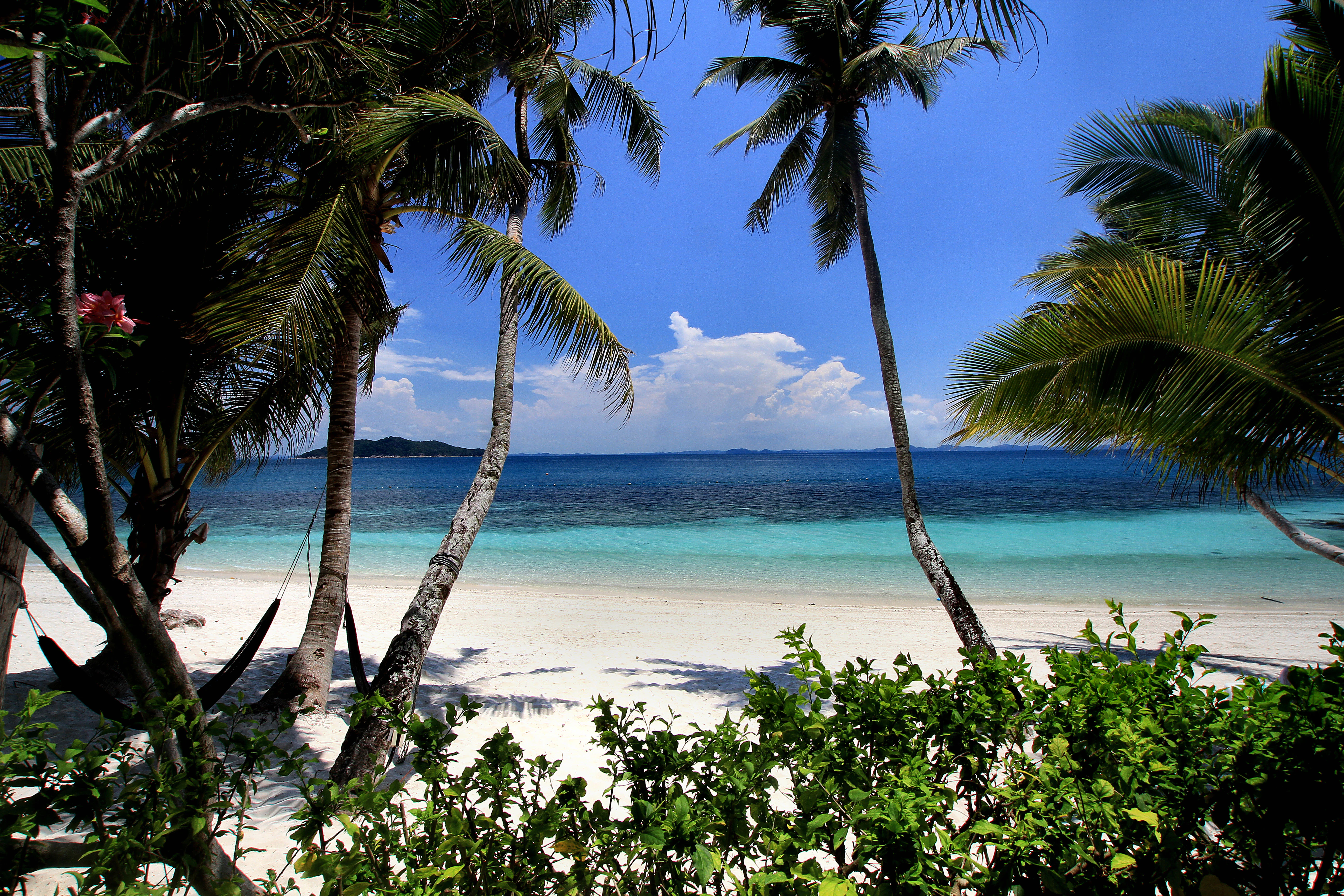
A view of a bright white sand beach and turquoise sea framed by tropical palm trees under a clear blue sky.
A view of the sandy beach and tropical waters on Rawa Island, Malaysia.

Rawa Island history and protected-area timeline

Rawa Island's documented history is closely tied to the Johor royal family, who own the island. The private royal ownership has shaped the island's character and its limited, resort-based development rather than mass tourism. The island entered broader public awareness through Malaysian travel media and later international coverage that highlighted it as one of Malaysia's appealing weekend-break island destinations. Its two main resorts, Rawa Island Resort and Alang's Rawa, have established it as a recognizable, if quiet, part of the country's tropical island offerings.

Rawa Island landscape and geographic character

Rawa Island's landscape is dominated by its small scale and the sharp contrast between its two coasts. The island offers a long stretch of clean white sand beach on the side that faces the open sea, where ocean swells naturally keep the shoreline clear. The opposite side of the island rises into a rocky vertical cliff that drops directly into the sea, giving the island a compact two-faced topography. Coconut trees and other tropical coastal vegetation cover much of the island's interior, and the absence of roads, replaced by simple walkways, preserves the natural feel of the terrain.
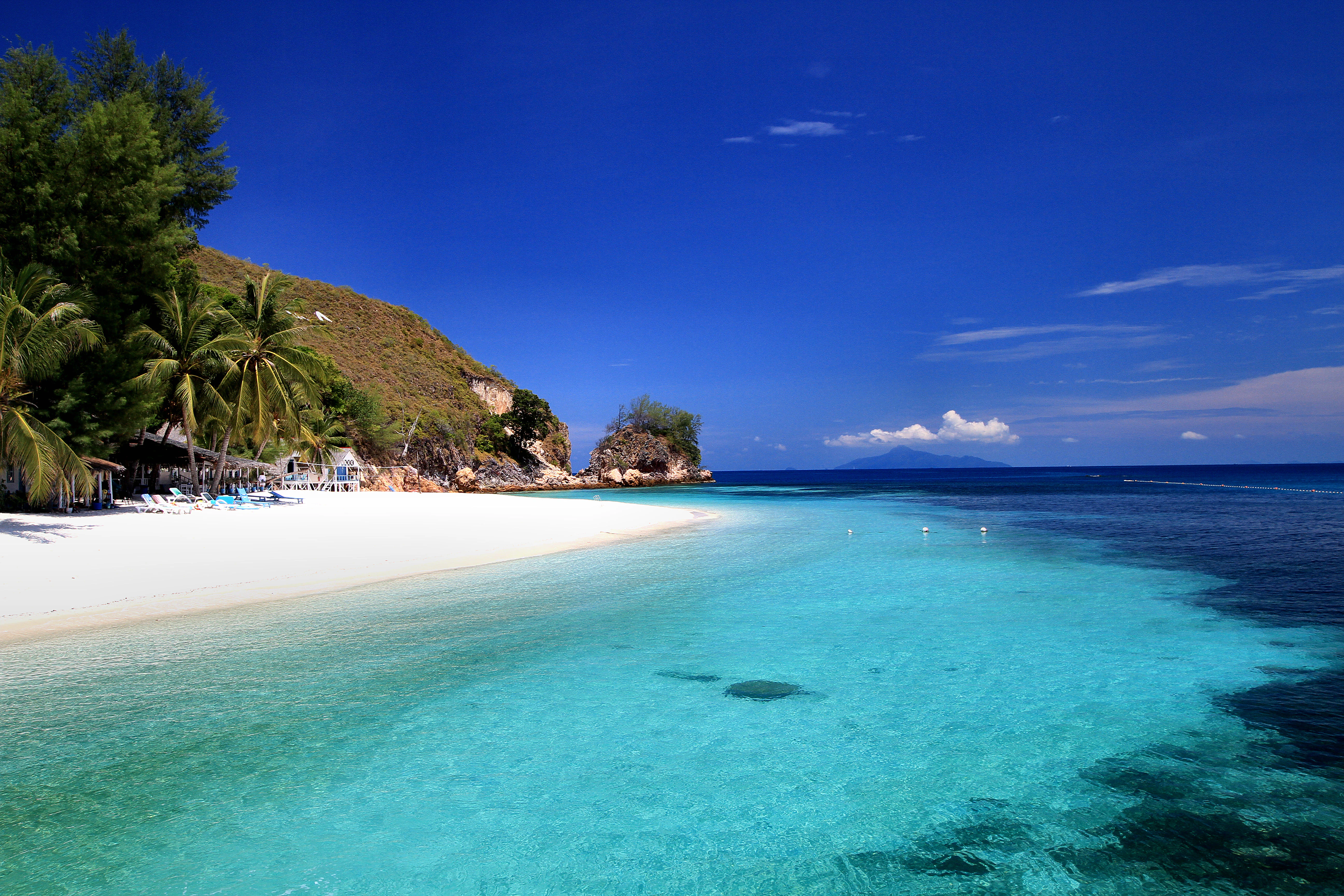
A wide angle view of a pristine white sandy beach bordering clear turquoise shallow water, with a rocky hillside and palm trees on the left under a deep blue sky.
A scenic view of the white sand beach and turquoise waters of Rawa Island, Malaysia.

Rawa Island ecosystems, habitats, and plant life

Ecologically, Rawa Island sits within the tropical marine and coastal zone of the South China Sea. The surrounding waters are clear and coral-rich, sustained by open-ocean exposure that limits sediment build-up along the beaches. Onshore, the vegetation reflects a typical small tropical island ecosystem, with coconut palms and other coastal species dominating the limited interior. The combination of rocky cliffs, white sand beaches, and clear shallow reef waters creates a compressed but biologically diverse environment for a coral island of its size.

Rawa Island wildlife and species highlights

Wildlife on and around Rawa Island reflects the mix of marine and terrestrial habitats typical of small tropical South China Sea islands. The surrounding reef waters support a rich variety of marine life including fish, squids, jellyfish, and octopuses, and are notable for the regular presence of blacktip reef sharks feeding offshore. The island's coral gardens contribute to this marine biodiversity by providing habitat structure for reef-associated species. On land, Malayan sea eagles are among the more visible birdlife, while various reptiles inhabit the island. The white doves that the island is named for remain an important symbolic and observable part of the local fauna.

Rawa Island conservation status and protection priorities

Rawa Island's conservation value lies primarily in the relative health of its marine environment, including its coral populations and the clear-water reef ecosystem that supports species such as blacktip reef sharks and other reef fauna. The island's private ownership and limited development have helped maintain the natural state of its beaches and coral shoreline. The open-sea exposure helps keep water conditions clear, which in turn supports coral growth and reef biodiversity. While the island is not designated as a formal protected area in the same way as larger national parks, its low-development character and royal-family ownership have functioned as informal stewardship of its marine and coastal environment.

Rawa Island cultural meaning and human context

Rawa Island holds a distinctive cultural position as a privately owned royal island belonging to the Johor royal family, which has shaped its restrained, resort-based tourism profile. Its name carries local linguistic meaning, with "rawa" referring to the white doves that are associated with the island. The island sits within a regional maritime culture of Johor that includes a constellation of small offshore islands such as Besar, Sibu, Tinggi, Harimau, and Mensirip, each with its own history of fishing, settlement, and small-scale tourism. The reach to Rawa from Mersing by fast boat reflects the broader pattern of island visits along Johor's east coast.

Top sights and standout views in Rawa Island

Rawa Island's strongest points of distinction are its clear, coral-rich waters, its clean white sand beach on the open-sea side, and the striking contrast with the rocky vertical cliff on the opposite coast. The island's small, walkable scale, private royal ownership, and limited development preserve a quiet tropical island atmosphere. The presence of blacktip reef sharks, healthy coral gardens, Malayan sea eagles, and the namesake white doves gives the island a distinctive and recognizable natural identity within Malaysia's island offerings.

Best time to visit Rawa Island

Rawa Island's tropical setting means warm conditions and clear waters across much of the year, with the open-ocean exposure generally keeping the beaches clean. Visiting during the months when sea conditions are calmer can offer the most comfortable experience for snorkeling around the coral areas and enjoying the white sand beach, while periods of stronger swell can emphasize the contrast with the rocky cliff side of the island. Travelers seeking the most settled marine conditions typically prefer periods outside the height of the monsoon-influenced seasons along the east coast of Peninsular Malaysia.
Monthly climate preview

Trace monthly average temperatures and precipitation cycles measured across standard climatology periods.

Rawa Island Climate Normals: Long Term Temperature and Precipitation Patterns

Rawa Island exhibits steady long term temperature ranges alongside measurable monthly precipitation shifts recorded from representative coordinate data. Examining the complete twelve month profile provides granular baseline statistics for analyzing local weather by month.
Annual mean27 °C
26 °C28 °C
Jan26°
Feb26°
Mar27°
Apr28°
May28°
Jun27°
Jul27°
Aug27°
Sep27°
Oct27°
Nov27°
Dec26°
Warmest month
May

27.9 °C

Coolest month
January

25.8 °C

Wettest month
December

12.5 mm/day

Driest month
February

3.9 mm/day

Park location guide

Geography guide, regional context, and park location map for Rawa Island

Rawa Island park geography, regions, and map view in Malaysia

Understand where Rawa Island sits in Malaysia through a broader geographic reading of the surrounding landscape, nearby location context, and its mapped position within the national park landscape.

How Rawa Island fits into Malaysia

Malaysia is a federal constitutional monarchy located in Southeast Asia. The country consists of 13 states and three federal territories, divided by the South China Sea into Peninsular Malaysia on the Indochinese Peninsula and East Malaysia on the island of Borneo. With a population of over 34 million, it achieved independence from Britain in 1957 and became a modern federation in 1963. The country is recognized for its multicultural population, tropical climate, and significant economic role in the region.

Wider geography shaping Rawa Island in Malaysia

Malaysia occupies a strategic position in Southeast Asia, split by the South China Sea into two distinct regions. Peninsular Malaysia lies on the Indochinese Peninsula, sharing a land border with Thailand to the north and maritime borders with Singapore, Vietnam, and Indonesia. East Malaysia occupies the northern portion of Borneo, sharing land borders with Brunei and Indonesia, and maritime borders with the Philippines and Vietnam. The country's terrain includes coastal plains, mountain ranges such as the Titiwangsa in the peninsula, and extensive tropical rainforests.

Map view of Rawa Island

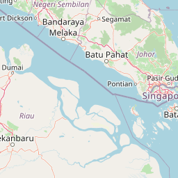
Use this park location map to pinpoint Rawa Island in Malaysia, understand its exact geographic position, and read its mapped placement within the surrounding landscape more clearly.

Pigeon | © OpenStreetMap contributors

Location context for Rawa Island

Johor

Explore detailed visual records of coral reefs, white sand beaches, and rocky coastal cliffs.

Rawa Island Landscape and Scenery Photography: Visualizing the Island

Visual documentation captures the sharp topographical contrast between open ocean beaches and sheer vertical cliffs along the coast. Detailed photographic records reveal the natural marine habitats, coral ecosystems, and undisturbed terrestrial terrain defining the island environment.

A view of a bright white sand beach and turquoise sea framed by tropical palm trees under a clear blue sky.

A wide angle view of a white sand beach meeting clear turquoise water on Rawa Island, with lush green hills in the background under a blue sky.

A wide angle view of a pristine white sandy beach bordering clear turquoise shallow water, with a rocky hillside and palm trees on the left under a deep blue sky.

Park atlas

Compare adjacent coastal landscapes, coral ecosystems, and island geographies.

Other Parks Near Rawa Island and Surrounding Regional Protected Areas

Browse protected areas near Rawa Island to evaluate neighboring marine habitats and regional island geography. Comparing connected coastal terrain provides broader context for understanding Malaysia's diverse marine ecosystems.
A minimalist watercolor illustration depicting a tropical island coastline with sand beaches, green trees, and rolling hills in the background.
Marine protected areaJohor
About 8.7 km away#1 closest

South

Besar Island Marine Protected Area: Coastal Geography and Protected Waters in Johor

Mapping the island's reef ecosystems and tropical landscape

Besar Island offers a distinct look at a small-scale marine protected area off the Johor coast. Its geography encompasses a transition from sandy beach fronts to a hilly, jungle-clad interior, all contained within a gazetted two-nautical-mile conservation zone. The surrounding waters support approximately 60 marine species, making this an essential case study for understanding protected marine habitats within the Babi Islands archipelago.

Area
4.77 km²
Relief
Upland
Climate
Tropical
Access
Easy access
Protected areaJohor
About 29 km away#2 closest

Southeast

Tinggi Island Protected Area: Geography, Rainforest Terrain, and Johor Coastal Map

Mountainous forest meets extensive coral-rich coastal waters.

Located southeast of Mersing, Tinggi Island is defined by its dramatic silhouette and dense rainforest interior. The protected landscape stretches from the elevated peak of Mount Semundu down to a shoreline of white sand and coastal caves, creating a distinct marine and terrestrial environment unique to the Johor region.

Water
Major water bodies
Season
Year-round
Marine protected areaJohor
About 37 km away#3 closest

South

Sibu Island: Marine Protected Area and Coastal Landscape Analysis

Mapping the coral reefs and pyroclastic terrain of the Johor coast

Sibu Island is a protected marine area in the South China Sea, distinguished by its unique pyroclastic geology and surrounding coral reef ecosystems. This entry provides a structured look at the island's coastal geography, vegetation, and maritime boundaries off the coast of Mersing, Johor. Access detailed geographic context for this tropical landscape.

Area
4.05 km²
Established
1993
Relief
Lowland
Climate
Tropical
Protected areaJohor
About 40 km away#4 closest

East

Pemanggil Island Protected Landscape: Johor Offshore Geography and Island Topography

Mapping coastal features and inland terrain in the South China Sea.

Pemanggil Island serves as a significant geographic landmark within the Mersing cluster of Johor. This detailed atlas entry focuses on the island's structural composition, including its prominent central hill, the rocky interior, and coastal features such as Teluk Lancang. Understand the maritime geography and spatial character of this protected area within the context of the southern Malay Peninsula.

Area
8.82 km²
Relief
Upland
Climate
Tropical
Access
Moderate access
A minimalist watercolor illustration depicting abstract green rolling hills and distant pink-toned ridges against a white background.
Wildlife reservePahang
About 40 km away#5 closest

Northeast

Pulau Tioman Wildlife Reserve: Mapping Island Rainforests and Marine Boundaries

Protected island geography within the Pahang region

Covering the forested interior of Tioman Island, this wildlife reserve protects lowland and hill rainforest habitats that rise to Gunung Kajang. The area serves as a significant conservation landscape, bridging remote inland mountain terrain with vibrant coral-fringed coastlines in the South China Sea.

Area
136 km²
Established
1972
Relief
Mountain
Climate
Tropical
National parkJohor
About 61 km away#6 closest

West

Endau-Rompin National Park: Ancient Tropical Rainforest Protected Landscape in Johor, Malaysia

Explore unique mapped geography and ancient geological features.

Endau-Rompin National Park in Johor, Malaysia, is a testament to Earth's ancient history, housing tropical rainforests built upon geological formations around 248 million years old. This protected area offers a detailed look at rugged mountainous terrain, vital river systems, and a diverse mapped landscape, crucial for understanding regional geography and conservation. Its status as one of the oldest rainforest complexes makes it a significant site for exploring the planet's prehistoric natural heritage and protected land distribution.

Area
870 km²
Established
1993
IUCN
II
Relief
Mountain
Watercolor illustration of a horizontal landscape featuring a winding river, green forests, and soft, pastel colored mountain ridges against a white background.
Marine protected areaJohor
About 61 km away#7 closest

East

Aur Island Marine Protected Area: Johor Regional Coastal and Island Geography

Rugged island terrain and sheltered coral ecosystems.

Aur Island serves as a significant marine protected area within the Johor Marine Park archipelago. Located in the South China Sea, the island is characterized by its hilly interior, white-sand shorelines, and diverse offshore coral reef systems. Its geographic proximity to neighbouring Dayang Island creates a paired landscape that highlights the environmental importance of these remote Malaysian waters.

Area
14.5 km²
Relief
Lowland
Climate
Tropical
Access
Moderate access
Nature reserveJohor
About 139 km away#8 closest

South

Pulai River Nature Reserve: Johor Coastal Mangrove and Estuarine Geography

Protected Ramsar wetland and coastal landscape in southern Malaysia.

Spanning from the highlands of Mount Pulai to the Tebrau Straits, Pulai River Nature Reserve acts as a major ecological interface in Johor. This site encompasses dense mangrove forest reserves and the country's single largest seagrass bed, serving as a primary study area for regional coastal conservation and wetland management.

Established
2003
Relief
Lowland
Scope
Mixed
Water
Water-dominated

Common questions about visiting, size, designation, and location context for Rawa Island

Rawa Island FAQs for park facts, access, geography, and protected area context

Find quick answers about Rawa Island, including protected-area facts, park geography, trail and visitor context, and how the park fits into its surrounding country and regional landscape.
MoriAtlas Explorer

Continue Your Protected Areas Search Across the Global Atlas

Deepen your exploration by continuing the structured search for national parks and protected areas worldwide. Utilize the comprehensive filtering capabilities to compare different conservation landscapes and refine your understanding of global park geography. Discover more about the distribution and characteristics of protected natural areas.

Global natural geography