

Mori Atlas logo
Wildlife reserveRed Rock-Secret Mountain Wilderness

Explore the dramatic geological transition between the Mogollon Rim and Verde Valley

Red Rock-Secret Mountain Wilderness: Mapping the Canyons and Mesas of Central Arizona

Red Rock-Secret Mountain Wilderness encompasses nearly 47,200 acres of protected terrain along the southern edge of the Colorado Plateau. This landscape is defined by deep red sandstone canyons, vertical cliffs, and forested mesas that drain toward the Verde River. The area provides a critical habitat for diverse species while showcasing the unique intersection of desert, riparian, and upland forest environments within Coconino National Forest.

wilderness areared rock canyonsslot canyonsnatural archesMogollon RimColorado Plateau

Red Rock-Secret Mountain Wilderness

Wildlife reserve

Park overview

Structured park overview, official facts, and landscape profile for Red Rock-Secret Mountain Wilderness

Red Rock-Secret Mountain Wilderness park facts, protected area profile, and essential visitor context

Review the core facts for Red Rock-Secret Mountain Wilderness, including designation, size, terrain, visitor scale, habitats, and operating context in one park-focused overview.

About Red Rock-Secret Mountain Wilderness

Red Rock-Secret Mountain Wilderness is one of the signature protected landscapes of central Arizona, encompassing almost 47,200 acres of canyon country straddling the Coconino and Yavapai county line near Sedona. Although the surrounding region is one of the most photographed landscapes in the American Southwest, the wilderness itself preserves a more rugged and less developed side of this iconic scenery. It sits where the Colorado Plateau breaks downward into the Verde River watershed, producing a sharp boundary between high forested rim and deep, sculpted red-rock canyons.

The wilderness is managed by the U.S. Forest Service as part of the Coconino National Forest and was formally designated in 1984. Its canyons drain into Oak Creek and the Verde River, with walls and gorges reaching approximately 1,500 feet in depth. The high mesas of Secret Mountain and Wilson Mountain rise prominently above this lower country, creating dramatic skylines that define the wilderness from below. Areas such as Boynton Canyon, Long Canyon, and the West Fork of Oak Creek Canyon are widely recognized both for their scenery and for their accessibility to hikers.

Ecologically, the wilderness captures a notable elevation-driven contrast. The high rim country is cooler and more heavily forested, while the lower canyons host warmer, drier vegetation characteristic of the Arizona desert transition zone. This gradient supports a wide range of wildlife, from large mammals such as elk, mule deer, and black bear to smaller species like javelina, coyotes, and mountain lions. Streamside corridors in canyon bottoms add still more habitat variety and contribute to the wilderness's rich plant and animal life.

Beyond its natural character, Red Rock-Secret Mountain Wilderness is an important cultural landscape. Prehistoric inhabitants left petroglyph panels and cliff dwellings throughout the canyon walls, and Sinagua ruins such as Honanki (located just south of the wilderness boundary) reflect the area's role in broader Ancestral Puebloan settlement patterns. Today, the wilderness is a major destination for hiking, horseback riding, photography, wildlife viewing, and backcountry exploration, with a dispersed trail network reaching everything from short strolls into box canyons to strenuous climbs onto high mesas and summits.

Quick facts and research context for Red Rock-Secret Mountain Wilderness

Red Rock-Secret Mountain Wilderness is a federally designated wilderness area of roughly 47,194 acres managed by the U.S. Forest Service within Arizona's Coconino National Forest. It is located in Coconino and Yavapai Counties near Sedona, straddling the dramatic transition zone between the Colorado Plateau and the lower Verde River country.

The wilderness was established in 1984 and is classified as IUCN Category Ib, reflecting its protected wilderness character. It contains a mix of red-rock cliffs, slot canyons, high mesas, and forested rim country, and shares a border with Sycamore Canyon Wilderness to the east. The area is notable both for its scenic canyon landscapes and for its archaeological sites, including Sinagua cliff dwellings and petroglyphs.

Protection and recognition

Documented terrestrial protection scope and conservation status facts

Red Rock-Secret Mountain Wilderness Protection Status and Recognition

Red Rock-Secret Mountain Wilderness maintains a verified terrestrial protection scope within the regional protected area network. Documented conservation status facts provide clear reference data for the protected landscape without external recognition sources.

Protection details

Protection scope
Terrestrial
Transboundary protection
No
Park context

Deeper park guide and search-rich context for Red Rock-Secret Mountain Wilderness

Red Rock-Secret Mountain Wilderness history, landscape, wildlife, and travel context

Explore Red Rock-Secret Mountain Wilderness through its history, landscape character, ecosystems, wildlife, conservation priorities, cultural context, and seasonal travel timing in a structured park guide built for atlas discovery and search intent.

Why Red Rock-Secret Mountain Wilderness stands out

Red Rock-Secret Mountain Wilderness is best known for its vivid red-rock canyon scenery on the edge of Arizona's Mogollon Rim, where sandstone cliffs, slot canyons, arches, and pinnacles have been carved by wind and water into a labyrinth of rock. The wilderness showcases the sharp environmental transition between the cool, forested Colorado Plateau and the warmer, lower desert country of the Verde Valley. It is also recognized for the rich collection of ancient cliff dwellings and petroglyph sites tucked into its canyon walls, evidence of long-term human presence in this dramatic landscape. Trails such as the West Fork, Boynton Canyon, and Secret Mountain routes draw visitors into a setting that combines geological spectacle, ecological diversity, and archaeological significance in a relatively compact area.
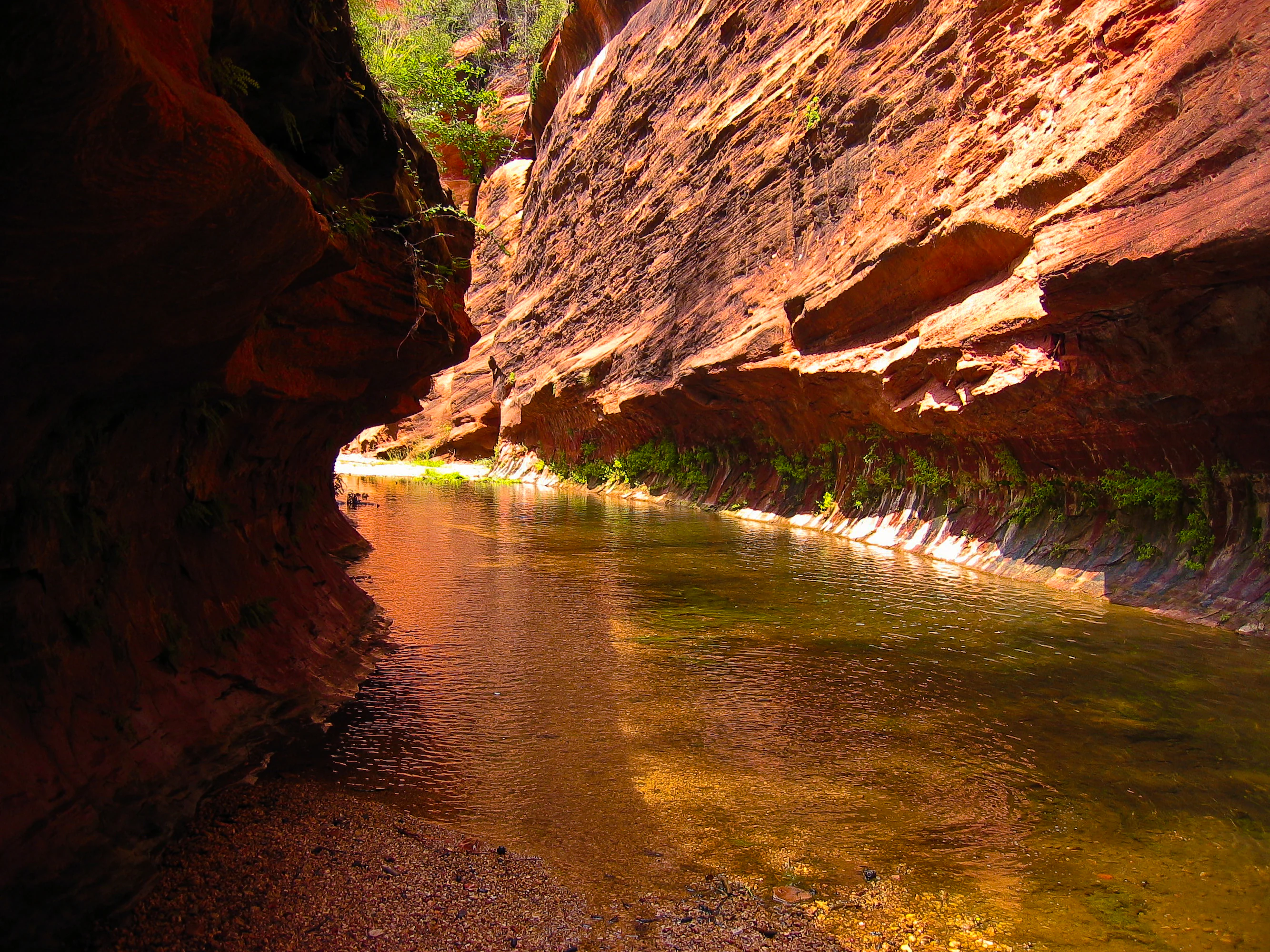
West Fork Trail in Oak Creek Canyon
View of the West Fork Trail within Oak Creek Canyon, Sedona. Photograph by Mark Chavez, August 2006. Credit: U.S. Forest Service, Coconino National Forest.

Red Rock-Secret Mountain Wilderness history and protected-area timeline

Red Rock-Secret Mountain Wilderness is a relatively modern federal designation, formally established in 1984, but the landscape it protects has been shaped by both natural processes and human use over far longer timescales.

The canyon walls and overhangs of the wilderness hold petroglyphs and abandoned cliff dwellings that reflect use of the area by Indigenous peoples, including Sinagua communities associated with sites such as Honanki on the southern edge of the wilderness. These archaeological traces indicate long-standing seasonal and ceremonial use of the canyons, water sources, and overlooks.

In the late nineteenth century, families such as the Samuel Loy family and settlers like C.S. "Bear" Howard established routes, now reflected in trails like Loy Canyon and A.B. Young, to move livestock between summer pastures on the Mogollon Rim and lower winter range. Some of these stock-driving paths were later rebuilt or improved during the 1930s by the Civilian Conservation Corps as part of national efforts to develop recreational infrastructure on national forest lands.

The area's inclusion in the Coconino National Forest placed it under U.S. Forest Service administration, and the 1984 wilderness designation added a higher level of protection, limiting road-building, mechanized use, and development to preserve its backcountry character. Since then, the wilderness has remained a key component of the protected canyon landscape surrounding Sedona.

Red Rock-Secret Mountain Wilderness landscape and geographic character

The landscape of Red Rock-Secret Mountain Wilderness is defined by the dramatic edge of the Colorado Plateau, known locally as the Mogollon Rim, where elevated forested country drops away into the deeply dissected red-rock canyons of the upper Verde River drainage. This escarpment produces the wilderness's most recognizable feature: steep red cliffs of sandstone, sculpted into pinnacles, windows, arches, and narrow slot canyons over millions of years of wind and water erosion.

Within the wilderness, two prominent high mesas, Secret Mountain and Wilson Mountain, jut out above the surrounding canyons, with deep drainages plunging as much as 1,500 feet toward Oak Creek and the Verde River. Drainages such as Boynton Canyon, Long Canyon, Hart Well Canyon, Dry Creek, and Sterling Canyon cut sharply into the plateau, often forming box canyons or narrow slot-like passages. East Pocket Knob on the Wilson Mountain massif is among the highest points in the wilderness.

Below the rim, the lower country becomes warmer and more arid, while the rim top and north-facing slopes retain denser coniferous and mixed forest cover. Streams and seeps in canyon bottoms, including the West Fork of Oak Creek Canyon, sustain ribbons of riparian vegetation that contrast strongly with the surrounding rock. The result is a landscape of striking vertical contrast, where forest, cliff, and canyon alternate in short distances, and where color shifts between the deep red of the sandstone and the green of the rim country are among the wilderness's most photographed attributes.
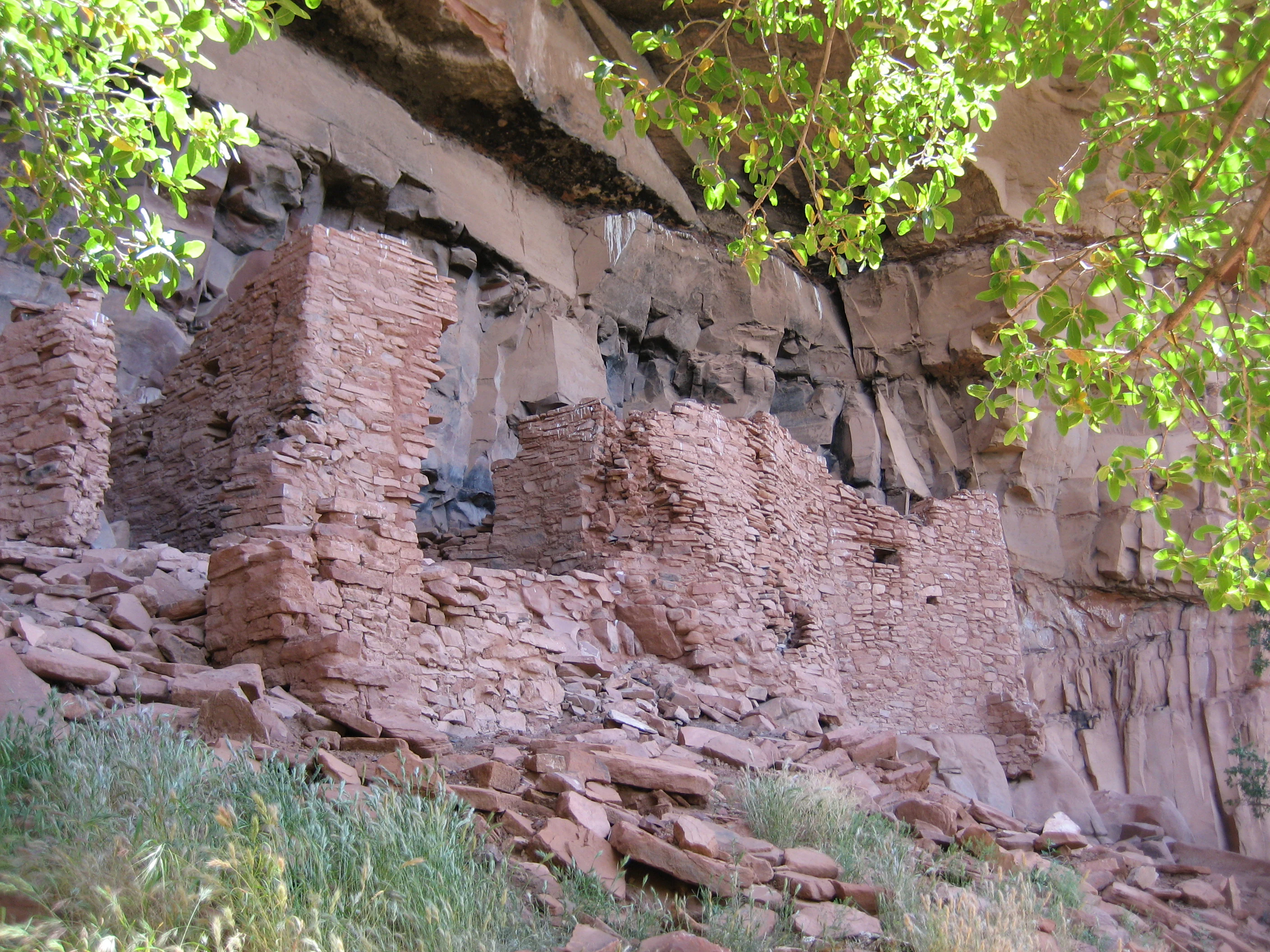
Honanki Sinagua ruin
Sinagua cliff dwellings located at Honanki, west of Sedona, Arizona

Red Rock-Secret Mountain Wilderness ecosystems, habitats, and plant life

The natural character of Red Rock-Secret Mountain Wilderness is strongly shaped by elevation, with a sharp ecological divide between the high rim and the lower canyon country. Above, the Mogollon Rim country is relatively cool and moist, supporting forests of ponderosa pine, mixed conifers, and Gambel oak that change color dramatically in autumn. Below, canyons descend into warmer vegetation zones characteristic of the Arizona desert transition, with manzanita, juniper, desert scrub, and riparian plant communities lining creek bottoms.

This compressed elevation range compresses into a single protected area what would otherwise be several distinct biomes. North-facing slopes and sheltered side canyons retain more mesic vegetation, while exposed south-facing cliffs and sandy canyon floors support drought-adapted plants. Riparian corridors along streams such as the West Fork of Oak Creek host lush plant communities that stand out sharply against the surrounding red rock, and serve as critical habitat and movement corridors for wildlife.

These varied habitats support a wide range of wildlife, including elk, mule deer, white-tailed deer, javelina, coyotes, rabbits, mountain lions, and black bears. Birdlife and smaller fauna also benefit from the diversity of plant communities. The interplay of forest, cliff, riparian, and desert environments gives the wilderness unusually high ecological richness for its size and explains why so much wildlife can persist here despite proximity to a popular destination town.

Red Rock-Secret Mountain Wilderness wildlife and species highlights

The ecological diversity of Red Rock-Secret Mountain Wilderness translates directly into a rich and visible wildlife presence. The wilderness supports a strong population of large ungulates, particularly elk and mule deer, with white-tailed deer using the more mesic rim and canyon bottom habitats. These herbivores, in turn, support predators such as mountain lions and coyotes, which move through both the forested rim country and the rougher canyon terrain.

Black bears are a notable presence in the wilderness, using the forested high country and canyon corridors especially during seasons of acorn and other mast availability. Javelina range through the lower, brushier parts of the area, often in family groups, while rabbits and other small mammals fill out the base of the food web. The vegetation gradient from dry, warm desert scrub to cooler mixed conifer forest allows different species to occupy adjacent but clearly different habitats within a short distance of each other.

Streamside habitats, particularly along the West Fork of Oak Creek and other canyon-bottom drainages, are especially important for wildlife, providing water, cover, and travel routes. Birdlife is varied, with raptors, songbirds, and seasonal migrants using both the cliffs and the forested slopes. Overall, the wilderness functions as a refuge of relatively intact wildlife habitat in a region otherwise heavily shaped by human development, making it a focal point for wildlife viewing in the Sedona area.

Red Rock-Secret Mountain Wilderness conservation status and protection priorities

Red Rock-Secret Mountain Wilderness is a formally designated wilderness area, classified under IUCN Category Ib and managed to preserve its undeveloped, backcountry character. The 1984 wilderness designation provides the highest level of protection typically afforded to U.S. Forest Service lands, restricting road construction, mechanized travel, commercial development, and other activities that could degrade the area's natural and cultural values.

From a conservation perspective, the wilderness is especially significant because it protects a representative slice of the Mogollon Rim transition zone, one of the most ecologically consequential boundaries in the American Southwest. By safeguarding the steep gradient from forested plateau to desert canyon in a single area, it preserves habitat complexity that supports a wide range of species and ecological processes.

The wilderness also conserves important cultural resources, including petroglyph sites and the setting for prehistoric cliff dwellings, alongside natural features such as arches, slot canyons, and riparian corridors along Oak Creek. Its proximity to, but formal separation from, the developed areas around Sedona makes it a critical refuge for wildlife and a continuing example of how arid-land canyons can be preserved as living, working wilderness rather than as purely scenic backdrop.

Red Rock-Secret Mountain Wilderness cultural meaning and human context

Red Rock-Secret Mountain Wilderness sits within a landscape long inhabited by Indigenous peoples, and its canyon walls preserve evidence of that use in the form of petroglyphs and abandoned cliff dwellings. The area is closely associated with Sinagua culture, whose sites such as Honanki lie just south of the wilderness boundary and whose presence is documented throughout the surrounding canyon country.

In more recent centuries, the canyons and rim country supported ranching activity, with families driving cattle up to summer pastures on the Mogollon Rim along routes later turned into recreational trails. Settlers such as C.S. "Bear" Howard and the Loy family left their names on paths that are still hiked today. Trails later improved by the Civilian Conservation Corps in the 1930s reflect a national movement to develop public recreation infrastructure and to provide employment during the Great Depression.

In the modern era, the wilderness has become part of the cultural identity of Sedona and central Arizona, framing the town's iconic red-rock vistas and shaping the area's reputation as a destination for outdoor recreation, photography, and reflection on the long human story written into these canyons.

Top sights and standout views in Red Rock-Secret Mountain Wilderness

Red Rock-Secret Mountain Wilderness combines red-rock canyon scenery, forested plateau rim, and archaeological heritage within a single protected area near Sedona, Arizona. Sandstone arches, slot canyons, and pinnacles carved along the edge of the Mogollon Rim give the wilderness a sculpted, otherworldly appearance that has made it one of the most photographed landscapes in the Southwest.

Equally important is the area's ecological character, which packs desert, riparian, and forest environments into a compact footprint, supporting elk, black bear, mule deer, javelina, mountain lions, and many other species. Coupled with deep human history visible in cliff dwellings and petroglyphs, and a trail network suited to both casual and experienced visitors, the wilderness offers a uniquely dense concentration of natural and cultural value just beyond the town of Sedona.

Best time to visit Red Rock-Secret Mountain Wilderness

Spring and autumn are generally the most rewarding seasons to experience Red Rock-Secret Mountain Wilderness. Spring brings warming temperatures, blooming wildflowers, and comfortable hiking conditions in the canyons, while autumn paints the rim country and canyon oaks in vivid fall colors, especially in drainages like Boynton Canyon.

Summer can be very hot in the lower canyon country, although the higher rim environments remain cooler and more comfortable and are a useful option for warm-weather visits. Winter is mild by regional standards, with snow occasionally dusting the rim, though ice and shorter days can make canyon hikes more challenging. Wildlife viewing tends to be most active around dawn and dusk during cooler months, when animals concentrate near water sources and canyon bottoms.
Monthly climate preview

Long term monthly averages for temperature and precipitation in Arizona

Red Rock Secret Mountain Wilderness Climate Normals and Temperature Patterns

Representative coordinate records show measured monthly averages ranging from sub-zero winter minimums to warm summer maximums alongside varying daily precipitation rates. Opening the comprehensive climate profile reveals full twelve month normals across the protected area.
Annual mean12 °C
1 °C23 °C
Jan
Feb
Mar
Apr10°
May15°
Jun21°
Jul23°
Aug22°
Sep19°
Oct12°
Nov
Dec
Warmest month
July

23.1 °C

Coolest month
December

1.1 °C

Wettest month
August

2.3 mm/day

Driest month
June

0.3 mm/day

Park location guide

Geography guide, regional context, and park location map for Red Rock-Secret Mountain Wilderness

Red Rock-Secret Mountain Wilderness park geography, regions, and map view in United States of America

Understand where Red Rock-Secret Mountain Wilderness sits in United States of America through a broader geographic reading of the surrounding landscape, nearby location context, and its mapped position within the national park landscape.

How Red Rock-Secret Mountain Wilderness fits into United States of America

The United States of America is a federal presidential republic and one of the world's largest countries by area and population. It consists of 50 states across a vast territory spanning multiple time zones, with its capital in Washington, D.C. and largest city in New York City. The nation has a diverse economy, influential political system, and significant cultural and military presence globally.

Wider geography shaping Red Rock-Secret Mountain Wilderness in United States of America

The United States occupies a vast territory in North America, bordered by Canada to the north and Mexico to the south. The 48 contiguous states stretch from the Atlantic to the Pacific Ocean, while Alaska occupies the northwestern region and Hawaii is an archipelago in the Pacific. The country encompasses diverse terrain including the Rocky Mountains, Appalachian Mountains, Great Plains, and extensive river systems.

Map view of Red Rock-Secret Mountain Wilderness

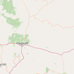
Use this park location map to pinpoint Red Rock-Secret Mountain Wilderness in United States of America, understand its exact geographic position, and read its mapped placement within the surrounding landscape more clearly.

Pigeon | © OpenStreetMap contributors

Location context for Red Rock-Secret Mountain Wilderness

Arizona
Recorded earthquake history

Explore Recorded Earthquake History for Red Rock-Secret Mountain Wilderness

Delve into the historical seismic record for the canyon lands of Red Rock-Secret Mountain Wilderness. This MoriAtlas catalogue provides structured access to recorded earthquake events and geographical data near this significant Arizona protected area, allowing for a clearer understanding of local seismic context.

Red Rock-Secret Mountain Wilderness Earthquakes

Catalogued events

17 events

Strongest magnitude

Magnitude 4.7

Most recent event

Jul 23, 2023

This history includes earthquakes recorded inside the park or within 50 km of its borders

Visual reference of sandstone cliffs, slot canyons, and forested rim country

Red Rock-Secret Mountain Wilderness Photos and Mapped Landscape Scenery

Visual documentation of Red Rock-Secret Mountain Wilderness reveals the stark geological contrast between wind-carved sandstone pinnacles and high forested mesas along the Mogollon Rim. Photographic records help researchers and visitors interpret the protected area's complex topography, riparian habitats, and deep canyon environments.

West Fork Trail in Oak Creek Canyon

Fall colors in Boynton Canyon

Honanki Sinagua ruin

Park atlas

Compare connected canyon terrain and surrounding protected landscapes across the region.

Explore Protected Areas and Parks Near Red Rock-Secret Mountain Wilderness

Continue browsing other national parks and protected areas near Red Rock-Secret Mountain Wilderness to examine neighboring sandstone formations and canyon ecosystems. Expanding the geographic comparison reveals broader regional terrain patterns and connected conservation corridors along the Mogollon Rim.
Protected areaArizona
2.3 km away#1 closest

Southwest

Prescott National Forest: Geographic Overview of Arizona Protected Landscapes and Wilderness

Regional geography and protected terrain map of the Bradshaw Mountains

Spanning over one million acres, Prescott National Forest represents a defining outdoor landscape in Arizona. The terrain transitions from high desert chaparral to dense ponderosa pine forests, featuring eight distinct wilderness areas, rugged canyon systems, and essential watershed corridors that shape the regional ecology near Prescott.

Area
5,100 km²
Established
1908
Relief
Mountain
Climate
Temperate
Wildlife reserveArizona
2.3 km away#2 closest

Southeast

Munds Mountain Wilderness Protected Area and Red Rock Landscape Mapping

Arizona high-desert wilderness and canyon-edge geography

Located southeast of Sedona, Munds Mountain Wilderness encompasses roughly 18,150 acres of dramatic sandstone cliffs and elevated plateaus. This area serves as a key site for observing the convergence of pinyon-juniper woodlands with iconic desert rock formations, providing a clear window into the rugged topography of central Arizona.

Area
73.45 km²
Established
1984
IUCN
Ib
Relief
Mountain
Protected landscapeArizona
5 km away#3 closest

North

Kaibab National Forest: Protected Plateau Landscapes and Forested Geography in Arizona

High-elevation forest terrain bordering the Grand Canyon

Spanning over 1.6 million acres in Arizona, Kaibab National Forest is characterized by its split geographic configuration, with distinct sections flanking the North and South rims of the Grand Canyon. The terrain ranges from the high-altitude Kaibab Plateau to volcanic uplands near Williams, encompassing four designated wilderness areas and varied forest ecosystems that provide a critical buffer for the surrounding canyon country.

Area
6,500 km²
Established
1909
Relief
Mountain
Climate
Temperate
Wildlife reserveArizona
28 km away#4 closest

Northeast

Kachina Peaks Wilderness; Geography and Protected Landscape Atlas of Arizona

High-altitude volcanic terrain and alpine ecosystems

Kachina Peaks Wilderness is a protected area in northern Arizona centered on the San Francisco Peaks. This geography includes the state's highest elevation at Humphreys Peak and a rare volcanic caldera known as the Inner Basin. The terrain transitions from dense mountain forests into an Arctic-Alpine zone, offering a distinct landscape for analyzing mountain evolution and high-elevation ecological patterns.

Area
75 km²
Established
1984
IUCN
Ib
Relief
Mountain
Protected landscapeArizona
53 km away#5 closest

South

Tonto National Forest: Understanding the Geography of an Expansive Protected Landscape

Exploring the vertical ecosystem gradients in Central Arizona

Spanning from arid Sonoran basins to the towering Mogollon Rim, Tonto National Forest offers a unique study in vertical geography and protected land management. This expansive territory provides a vital map of Southwest life zones, encompassing reservoir systems, rugged river canyons, and critical wilderness habitat that define the environmental identity of the region.

Area
11,627 km²
Established
1905
Visitors
5.9M annual
Relief
Mountain
Wildlife reserveArizona
55 km away#6 closest

South

Mazatzal Wilderness: Geographic Overview of Arizona's Expansive Protected Mountain Terrain

Mapping the ecological transition from desert canyon to forest ridge

Mazatzal Wilderness stands as an essential protected area in central Arizona, covering vast tracts of the Tonto and Coconino National Forests. The landscape is defined by the stark vertical contrast between the low-lying Verde River corridor and the high-elevation forests of the Mazatzal Mountains. This expansive wilderness remains a key study in regional topography and ecological zonation for those exploring the rugged backcountry of the southwestern United States.

Area
1,021.4 km²
Established
1964
IUCN
Ib
Relief
Mountain
Wildlife reserveYavapai County
About 87 km away#7 closest

West

Juniper Mesa Wilderness: Geological Landscape and Protected Area Mapping

Essential protected land data in Yavapai County

Juniper Mesa Wilderness protects a rare sedimentary mesa capped by Tapeats sandstone, rising above a vast granite landscape in Yavapai County. This geographic survey highlights the canyon-cut topography and the shifting vegetation zones that characterize the Transition Zone ecology within the Prescott National Forest.

Area
29.97 km²
Established
1984
IUCN
Ib
Relief
Mountain
National parkArizona
101 km away#8 closest

North

Grand Canyon National Park: Arizona National Park Protected Landscape & Geography

Explore mapped boundaries and regional atlas context.

Grand Canyon National Park stands as a premier national park, showcasing a unique protected landscape within Arizona's diverse geography. This detailed entry focuses on the park's specific geographic identity, its mapped boundaries, and its significance within the regional atlas. Discover the contours of this protected area and its place in the natural terrain of the American Southwest.

Area
4,926.08 km²
Established
1919
IUCN
II
Visitors
4.9M annual

Common questions about visiting, size, designation, and location context for Red Rock-Secret Mountain Wilderness

Red Rock-Secret Mountain Wilderness FAQs for park facts, access, geography, and protected area context

Find quick answers about Red Rock-Secret Mountain Wilderness, including protected-area facts, park geography, trail and visitor context, and how the park fits into its surrounding country and regional landscape.
MoriAtlas Explorer

Continue Your Protected Areas Search Across the Global Atlas

Deepen your exploration by continuing the structured search for national parks and protected areas worldwide. Utilize the comprehensive filtering capabilities to compare different conservation landscapes and refine your understanding of global park geography. Discover more about the distribution and characteristics of protected natural areas.

Global natural geography