Mori Atlas logo
Wildlife reserveRefugio de Vida Silvestre Marino Costera Pacoche

A detailed map and geographic overview of Ecuador's integrated marine and forest wildlife refuge

Refugio de Vida Silvestre Marino Costera Pacoche Protected Landscapes and Coastal Geography

Refugio de Vida Silvestre Marino Costera Pacoche serves as a vital protected area on the central coast of Ecuador, where the Manta peninsula intersects with the Pacific Ocean. This wildlife reserve encompasses a complex transition zone featuring dry tropical forests, rocky sea cliffs, and nearshore marine environments within Manabí. The mapped terrain documents the ecological link between the coastal hills rising toward Cerro Montecristi and the sedimentary offshore waters.

coastal reservemarine-coastal refugeTumbesian ecoregiondry tropical forestcactus scrubcoastal cliffs

Refugio de Vida Silvestre Marino Costera Pacoche

Wildlife reserve

Park overview

Structured park overview, official facts, and landscape profile for Pacoche Marine and Coastal Wildlife Refuge

Pacoche Marine and Coastal Wildlife Refuge park facts, protected area profile, and essential visitor context

Review the core facts for Pacoche Marine and Coastal Wildlife Refuge, including designation, size, terrain, visitor scale, habitats, and operating context in one park-focused overview.

About Pacoche Marine and Coastal Wildlife Refuge

Pacoche Marine and Coastal Wildlife Refuge protects a rich ecological transition zone along Ecuador's central Manabí coast. Unlike many of Ecuador's larger Amazonian or Andean parks, Pacoche's identity is shaped by its coastal geography: a relatively narrow belt where the Manta peninsula descends toward the sea in a sequence of cliffs, small alluvial valleys, and marine terraces, covered by one of the more botanically diverse dry to semi-humid forests of the Tumbesian region.

The refuge is built around the Pacoche forests and the Pacoche mountain range, a chain of hills that culminates in the El Domo area near El Aromo and extends southward toward Cerro Montecristi. This terrain shelters both seasonally dry forest on lower slopes and more humid forest communities in ravines and upper zones, while the adjacent coastline features cactus-rich scrub, halophytic vegetation near sea spray zones, rocky cliffs, sand and gravel beaches, and small offshore coastal islets.

Ecologically, Pacoche bridges several distinct environments. Its marine component includes soft sandy and rocky seafloors, nearshore environments that host benthic organisms, and clear Pacific waters that support seabirds, pelicans, and seasonal migrants. Its terrestrial component ranges from coastal cliffs and mangrove edges to dry forest, low-stature spiny forest, and interior humid forest. The overlap between marine, coastal, and interior forest habitats gives Pacoche its distinctive profile and creates conditions for a wide range of bird, mammal, reptile, and plant species to occur within a relatively small protected footprint.

Culturally and administratively, the refuge is significant for coastal Ecuador because it preserves one of the few remaining humid forest corridors near Manta, a region that has experienced extensive agricultural conversion and urbanization. The combination of protected coastal land, marine area, and contiguous forested hills makes Pacoche an important reference site for understanding and managing coastal ecosystem health on Ecuador's central Pacific shore.

Quick facts and research context for Pacoche Marine and Coastal Wildlife Refuge

Pacoche Marine and Coastal Wildlife Refuge lies in Manabí Province, Ecuador, between the cantons of Manta and Montecristi, just southwest of the city of Manta and north of Puerto Cayo. Administered by Ecuador's Ministry of the Environment, it was established on 2 September 2008 under Interministerial Agreement 131, with later modifications listed under Ministerial Agreement 359 of November 2014.

The refuge includes both terrestrial ecosystems and marine-coastal environments, combining seasonal dry forest, humid lowland forest, cactus scrub, cliffs, small coastal islands such as those offshore near Cabo San Lorenzo, and nearshore Pacific waters. As part of the Tumbesian ecoregion, it plays a key role in protecting coastal ecosystem connectivity between the Manta peninsula and the surrounding sea.

Protection and recognition

Examine documented protection scope, management details, and international recognition records.

Refugio de Vida Silvestre Marino Costera Pacoche Protection Status and Recognition

Refugio de Vida Silvestre Marino Costera Pacoche holds a documented mixed protection scope within its designated coastal territory. Verified records compile formal designation details, management frameworks, and international recognition sources where available.

Protection details

Protection scope
Mixed
Transboundary protection
No
Park context

Deeper park guide and search-rich context for Pacoche Marine and Coastal Wildlife Refuge

Pacoche Marine and Coastal Wildlife Refuge history, landscape, wildlife, and travel context

Explore Pacoche Marine and Coastal Wildlife Refuge through its history, landscape character, ecosystems, wildlife, conservation priorities, cultural context, and seasonal travel timing in a structured park guide built for atlas discovery and search intent.

Why Pacoche Marine and Coastal Wildlife Refuge stands out

Pacoche is best known for its interface between the dry coastal forests of the Tumbesian ecoregion and the Pacific Ocean, where seasonal forest, cactus scrub, rocky cliffs, and nearshore waters converge in a relatively compact protected area near Manta. The refuge is also a notable birding site in Ecuador. Its avifauna includes seabirds such as frigatebirds, boobies, pelicans, and the Peruvian Pelican, alongside cranes, herons, hawks, parrots including the Pacific Parrotlet, and endemic-rich forest species. Several Mojave-affiliated or Tumbesian-endemic species reach the northern edge of their range here, distinguishing the refuge as an important site for both resident and migratory birds.

Pacoche Marine and Coastal Wildlife Refuge history and protected-area timeline

The refuge was formally created on 2 September 2008 through Interministerial Agreement 131, registered in the Official Gazette No. 444 of 13 October 2008 as a Refugio de Vida Silvestre, or Wildlife Refuge, a national protected-area category managed by Ecuador's Ministry of the Environment.

Its establishment responded to the need to protect the remaining patches of Pacoche forest and the surrounding marine-coastal environment near Manta, a region that had experienced significant pressure from agriculture, coastal development, and unregulated resource use. The refuge brought together conservation priorities for both the terrestrial Pacoche forests and the rich coastal and marine ecosystem stretching from Cabo San Lorenzo to the area north of Puerto Cayo.

In November 2014, Ministerial Agreement 359 introduced modifications to the original designation, updating the legal framework for the protected area. These changes strengthened the institutional basis of the refuge and helped consolidate its role within Ecuador's national system of protected areas.

Several small coastal localities are recognized within the refuge, reflecting both ecological zones and traditional human settlements along the coast. Over time, the refuge has become a point of reference for coastal conservation in Manabí and for the broader recognition of the Tumbesian ecoregion's ecological importance on Ecuador's central coast.

Pacoche Marine and Coastal Wildlife Refuge landscape and geographic character

The terrestrial landscape of Pacoche is defined by the meeting between the Manta peninsula and the Pacific Ocean. From the interior, the terrain rises toward Cerro Montecristi, with subsidiary hills forming the Pacoche range; the high point of El Aromo near El Domo and the broader ridge structure mark the core of the dry and semi-humid forest zone. Slopes on the northern face of the peninsula tend to be steep, while the southern flank descends through gentler slopes and flat surfaces underlain by Pliocene marine sediments.

Toward the coast, the protected area transitions into a narrow belt of cliffs, small alluvial valleys, and beaches. Medium-angle cliffs cut into soft sedimentary rocks dominate much of the shoreline, interrupted periodically by smaller valleys where intermittent streams reach the sea. Sedimentary formations such as shales, limestones, clays, sandstones, and colluvial deposits underlie much of this coastal platform, with volcanic basalt appearing at the tip of Cabo San Lorenzo.

The marine portion of the refuge covers nearshore waters from the surf zone out to several kilometers offshore, where seafloor depths generally range from shallow surf waters to around 200 meters. Most of the seafloor consists of coarse, medium, and fine sand driven by seasonal river-mouth sediment input, while gravel and submerged rocky outcrops reflect older marine sedimentary formations. This mosaic of sandy bottoms, rocky areas, and steep underwater slopes creates varied habitats for benthic organisms, fish, and other forms of marine life.

Pacoche Marine and Coastal Wildlife Refuge ecosystems, habitats, and plant life

Pacoche lies within the Tumbesian ecoregion, also called the equatorial dry forest region, which spans southwestern Ecuador and northwestern Peru. This region is recognized for its biological richness and high levels of endemism despite being one of the most threatened tropical forest ecosystems on the Pacific coast of South America.

The vegetation of Pacoche reflects the strong climatic gradient of the refuge. In coastal zones exposed to salt spray and drought, low spiny forest, cactus scrub, and halophytic plants such as Salicornia dominate. Moving inland, on lower slopes and plains, seasonally dry tropical forest with deciduous trees and thorny shrubs becomes common. In more humid ravines and on upper slopes toward Cerro Montecristi, the forest becomes taller and more evergreen, with characteristic species such as Cordia, Bursera, Ceiba, Ficus, and various legumes.

The vascular plant list for the refuge includes hundreds of species across ferns, epiphytes, lianas, cacti, deciduous trees, and fruit-bearing trees, including mango, papaya, citrus, guava, passion fruit, cacao, and a range of native timber and ornamental species. This plant diversity supports a wide array of insects and birds, contributing to the refuge's strong ecological network and reinforcing its value as a refuge for coastal biodiversity.

Pacoche Marine and Coastal Wildlife Refuge wildlife and species highlights

Pacoche's most conspicuous wildlife value lies in its birds. The recognized avifauna of the refuge exceeds 200 species, combining seabirds and shorebirds using coastal and marine habitats with forest-dependent birds associated with the Pacoche forest patches and Pacoche mountains.

Among seabirds and coastal species, the refuge supports the Magnificent Frigatebird, Peruvian Booby, Blue-footed Booby, Brown Pelican, Peruvian Pelican, and Red-billed Tropicbird. Shorebirds include Wilson's Plover and Spotted Sandpiper, while herons such as the Little Blue Heron occur in nearshore wetlands.

Forest and edge habitats host a wide range of raptors, doves, parrots, and passerines. Notable species include the Hook-billed Kite, Double-toothed Kite, Gray-backed Hawk, Barred Hawk, Savanna Hawk, Short-tailed Hawk, and Laughing Falcon, alongside parrots such as the Red-masked Parakeet, Pacific Parrotlet, Gray-cheeked Parakeet, Blue-headed Parrot, and Bronze-winged Parrot. Hummingbirds are especially diverse, with species like the Ecuadorian Hermit, Violet-bellied Hummingbird, Rufous-tailed Hummingbird, and Esmeraldas Woodstar illustrating the refuge's importance for nectar-feeding birds.

In addition to birds, the refuge protects populations of mammals typical of the coastal Tumbesian region, reptiles and amphibians associated with both forest and dry coastal habitats, and a range of marine life including benthic invertebrates and reef-associated fish. The combination of forest birds, seabirds, and small oceanic wildlife gives Pacoche a layered wildlife profile unusual for a relatively small coastal-marine protected area.

Pacoche Marine and Coastal Wildlife Refuge conservation status and protection priorities

Pacoche protects one of the last expanses of relatively intact dry and semi-humid coastal forest near Manta and Montecristi, in a region where urbanization, agriculture, and tourism pressure have dramatically reduced native vegetation cover. Its protected status places the Pacoche forests and Pacoche mountain range under national conservation oversight, preventing further fragmentation and conversion of these habitats.

At a broader scale, the refuge anchors a portion of the Tumbesian ecoregion in Ecuador. This ecoregion has high levels of plant and bird endemism and is recognized as a conservation priority for the Pacific coast of South America. By connecting coastal cliffs, marine waters, and interior forest, Pacoche contributes to landscape connectivity for species that depend on multiple habitat types, including seabirds, migratory shorebirds, and forest birds that use both coastal and interior vegetation.

The marine component of the refuge is equally significant. Ecologically important nearshore seafloors, coastal cliffs, and small offshore features support benthic communities and feeding habitat for fish and seabirds. By regulating activities within its boundaries and protecting these habitats from overuse, the refuge helps maintain ecological processes at the land-sea interface along Ecuador's central coast.

Pacoche Marine and Coastal Wildlife Refuge cultural meaning and human context

The Pacoche area has long been associated with the coastal communities of Manabí, where fishing, small-scale agriculture, and forest-based livelihoods have shaped human interaction with the land and sea for generations. Settlements along the coast, including the area between Manta and Puerto Cayo, continue to maintain traditional relationships with marine and forest resources.

The Pacoche forests, in particular, have local cultural significance as one of the iconic forested landscapes of the Manta peninsula. References to the Pacoche range and its forests are part of regional identity in Manabí, and the area has long been recognized locally for its natural richness, including the sight of coastal birdlife, forest patches, and characteristic dry-forest vegetation that distinguishes the region.

Top sights and standout views in Pacoche Marine and Coastal Wildlife Refuge

Pacoche Marine and Coastal Wildlife Refuge stands out as a compact but ecologically layered protected area where dry Tumbesian forest, coastal cliffs, cactus scrub, and nearshore Pacific waters meet within a few kilometers of each other. Its concentration of bird species within such a small area, from seabirds and shorebirds to parrots, hummingbirds, and forest raptors, makes it an unusually rich site for coastal birdwatching in Ecuador.

The refuge also illustrates the importance of integrated land-sea conservation. Rather than focusing only on terrestrial or only on marine ecosystems, Pacoche protects both, recognizing the ecological links between forest, coast, and ocean. This integrated approach gives the refuge particular significance for biodiversity conservation on Ecuador's central coast.

Best time to visit Pacoche Marine and Coastal Wildlife Refuge

The climate of Pacoche is tropical megathermic and arid to semi-arid, with annual rainfall concentrated mainly between January and April. Annual precipitation is generally below 500 mm and can be highly variable due to occasional El Niño events, which can dramatically increase rainfall and reshape both forest and coastal conditions.

Temperatures remain relatively warm year-round, with annual averages around 24°C, daytime highs rarely exceeding 32°C, and nighttime lows typically around 16°C. The dry season, generally from May through December, tends to offer calmer conditions for coastal exploration and clearer views of forest and cliff habitats. The wetter months bring more dramatic vegetation and active birdlife, though conditions can be more humid and variable. Birdwatching is generally good in both seasons, with resident species present year-round and migratory shorebirds and seabirds adding seasonal interest.
Monthly climate preview

Long-term monthly temperature averages and precipitation rhythms at a representative coordinate

Refugio de Vida Silvestre Marino Costera Pacoche Climate Normals and Temperature Patterns

Historical data records sustained annual thermal ranges and distinct seasonal precipitation shifts across the protected landscape. Examining the full monthly climatology profile reveals complete temperature distributions and rainfall metrics.
Annual mean25 °C
24 °C25 °C
Jan25°
Feb25°
Mar25°
Apr25°
May25°
Jun24°
Jul24°
Aug24°
Sep24°
Oct24°
Nov24°
Dec25°
Warmest month
March

25.5 °C

Coolest month
September

23.7 °C

Wettest month
February

6.1 mm/day

Driest month
August

0.1 mm/day

Park location guide

Geography guide, regional context, and park location map for Pacoche Marine and Coastal Wildlife Refuge

Pacoche Marine and Coastal Wildlife Refuge park geography, regions, and map view in Ecuador

Understand where Pacoche Marine and Coastal Wildlife Refuge sits in Ecuador through a broader geographic reading of the surrounding landscape, nearby location context, and its mapped position within the national park landscape.

How Pacoche Marine and Coastal Wildlife Refuge fits into Ecuador

Ecuador is a presidential republic located in northwestern South America, with Quito as its capital and Guayaquil as its largest city. The country spans 283,561 km² and encompasses the Galápagos Islands, a volcanic archipelago famous for unique wildlife that helped shape Darwin's theory of evolution. Ecuador is a plurinational state with Spanish as the official language, though Kichwa and Shuar are recognized for indigenous peoples.

Wider geography shaping Pacoche Marine and Coastal Wildlife Refuge in Ecuador

Ecuador is located in northwestern South America along the Pacific coast. It shares borders with Colombia to the north and Peru to the east and south. The country includes the Galápagos Islands, a volcanic archipelago in the Pacific Ocean approximately 1,000 km west of the mainland. The territory encompasses diverse terrain including the Amazon rainforest in the east, the Andean highlands in the center, and coastal plains along the Pacific.

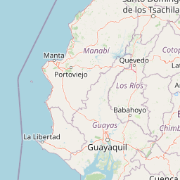
Map view of Pacoche Marine and Coastal Wildlife Refuge

Use this park location map to pinpoint Pacoche Marine and Coastal Wildlife Refuge in Ecuador, understand its exact geographic position, and read its mapped placement within the surrounding landscape more clearly.

Pigeon | © OpenStreetMap contributors

Location context for Pacoche Marine and Coastal Wildlife Refuge

Manabí
Park atlas

Compare surrounding coastal reserves and Tumbesian ecoregion landscapes across the region

Other Parks Near Refugio de Vida Silvestre Marino Costera Pacoche and Regional Protected Areas

Browsing other protected areas near Refugio de Vida Silvestre Marino Costera Pacoche reveals wider ecological connections across Ecuador's central coast and marine environments. Comparing adjacent reserves helps place individual coastal habitats and dry forest zones into a broader regional geography.
National parkManabí Province
About 29 km away#1 closest

South

Machalilla National Park: Protected Area and Geographic Context in Manabí Province

Explore mapped natural landscapes and regional geography.

Delve into Machalilla National Park, a protected national park situated in Ecuador's Manabí Province. This page provides a focused view on its protected landscape character, emphasizing its geographic setting and mapped natural terrain. Understand how Machalilla National Park fits into the regional geography, offering a distinct case study for protected-area discovery and landscape atlas exploration.

Area
750.59 km²
Established
1979
IUCN
II
A horizontal watercolor painting showing a pale green and soft pink landscape with rolling hills in the background, a flat expanse of light green vegetation in the midground, and a suggestion of water in the foreground.
Marine protected areaSanta Elena
About 97 km away#2 closest

South

Reserva Marina El Pelado: Coastal Marine Protected Area and Underwater Reef Geography

Oceanic convergence zone within the Santa Elena province

Reserva Marina El Pelado features a distinct maritime landscape defined by thirteen submarine shoals, octocoral forests, and coastal mangrove systems. Located within the Santa Elena province, this protected area serves as an essential biological laboratory where tropical and temperate current systems collide, shaping a complex mosaic of rocky reefs and diverse marine habitats.

Area
131.55 km²
Established
2012
IUCN
VI
Relief
Lowland
Wildlife reserveSanta Elena
About 126 km away#3 closest

South

Reserva de Producción de Fauna Marino Costero Puntilla Santa Elena Protected Area Map

Coastal marine geography and Pacific wildlife habitat exploration.

Investigate the marine-coastal expanse of the Reserva de Producción de Fauna Marino Costero Puntilla Santa Elena. This protected area encompasses diverse Pacific habitats, from arid shoreline vegetation to vast ocean sectors, serving as a critical environment for marine mammal migration and conservation in Santa Elena.

Area
524.34 km²
Relief
Lowland
Climate
Arid
Access
Easy access
A horizontal watercolor painting showing a stylized forest landscape with soft pastel green, yellow, and pink hues representing trees and rolling hills.
Protected areaGuayas
About 158 km away#4 closest

Southeast

Bosque Protector Cerro Blanco: Protected Area and Tropical Dry Forest Geography in Guayas

Mapped terrain of the Chongon-Colonche mountain range

Bosque Protector Cerro Blanco functions as a major conservation site in coastal Ecuador, protecting rare Tumbesian forest ecosystems within the Guayas province. The reserve features diverse topography of ridges and valleys, serving as a critical buffer for regional endemic species and offering a unique look at seasonally dry forest landscapes near Guayaquil.

Area
60.78 km²
Established
1992
Visitors
12K annual
Relief
Upland
Nature reserveGuayas
About 158 km away#5 closest

Southeast

Bosque Protector La Prosperina Nature Reserve and Coastal Ecuador Forest Geography

Protected dry forest habitat and regional geographic terrain

Bosque Protector La Prosperina represents a critical survival of Ecuador's equatorial dry forest within the Guayas province. This nature reserve offers deep insight into seasonal ravine networks, drought-adapted vegetation, and the structural dynamics of fragmented coastal landscapes near Guayaquil.

Area
2.424 km²
Established
1994
Relief
Upland
Climate
Tropical
Wildlife reserveGuayas
About 169 km away#6 closest

Southeast

Reserva de producción de fauna Manglares El Salado: Coastal Geography and Protected Lands

A mangrove-dominated wildlife reserve in Guayas, Ecuador.

Analyze the protected landscape of Reserva de producción de fauna Manglares El Salado, which spans extensive mangrove forests and estuarine waters within the Guayas province. This wildlife reserve showcases a unique transition between intertidal mangrove zones, salt flats, and remnants of tropical dry forest, providing essential habitat context for the Gulf of Guayaquil coastal region.

Area
53.09 km²
Established
2002
IUCN
VI
Relief
Lowland
Nature reserveEsmeraldas
About 174 km away#7 closest

Northeast

Reserva Ecológica Mache-Chindul: Coastal Mountain and Tropical Forest Protected Geography

Mapping the biodiversity of Esmeraldas provincial wilderness

Spanning over 119,000 hectares, Reserva Ecológica Mache-Chindul stands as a primary ecological shield against landscape degradation in coastal Ecuador. This site preserves rare mature forest mosaics, from dense Chocó lowland rainforest to misty high-altitude ridges. Gain geographic insight into this vital wilderness area through its distinct watershed basins and protected forest corridors.

Area
1,191.72 km²
Established
1996
IUCN
Ia
Relief
Mountain
Wildlife reserveEsmeraldas
About 178 km away#8 closest

Northeast

Refugio de Vida Silvestre Manglares Estuario Río Muisne Coastal Wildlife Reserve

Esmeraldas, Ecuador protected estuarine landscape

Discover the complex geography of Refugio de Vida Silvestre Manglares Estuario Río Muisne, a vital wildlife refuge protecting all six native mangrove species. This area spans a rich transition of marine and brackish waters, tidal flats, and forest stands that define the northwestern Pacific coastline of Ecuador.

Area
922.46 km²
Established
2003
Relief
Lowland
Access
Access unknown

Common questions about visiting, size, designation, and location context for Pacoche Marine and Coastal Wildlife Refuge

Pacoche Marine and Coastal Wildlife Refuge FAQs for park facts, access, geography, and protected area context

Find quick answers about Pacoche Marine and Coastal Wildlife Refuge, including protected-area facts, park geography, trail and visitor context, and how the park fits into its surrounding country and regional landscape.
MoriAtlas Explorer

Continue Your Protected Areas Search Across the Global Atlas

Deepen your exploration by continuing the structured search for national parks and protected areas worldwide. Utilize the comprehensive filtering capabilities to compare different conservation landscapes and refine your understanding of global park geography. Discover more about the distribution and characteristics of protected natural areas.

Global natural geography