Mori Atlas logo
Wildlife reserveRefugio de Vida Silvestre Samama Mumbes

Tracking the ecological boundaries and mountainous terrain of this vital Chocó reserve

Refugio de Vida Silvestre Samama Mumbes: Foothill Forest and Protected Watershed Map

(Refugio de Vida Silvestre Samama Mumbes (RVSSM))

Refugio de Vida Silvestre Samama Mumbes preserves a critical fragment of the Chocó Ecuatorial forest on the western Andean slopes of Ecuador. Spanning mountainous terrain between 150 and 740 meters in elevation, the reserve serves as a sanctuary for endemic flora and birdlife while providing essential hydrological regulation for the Babahoyo river system. This protected area stands as a rare remnant of native lowland evergreen forest in an otherwise extensively cultivated regional geography.

chocó forestwestern andesfoothill forestwildlife refugeendemic floraorchids

Refugio de Vida Silvestre Samama Mumbes

Wildlife reserve

Park overview

Structured park overview, official facts, and landscape profile for Refugio de Vida Silvestre Samama Mumbes

Refugio de Vida Silvestre Samama Mumbes park facts, protected area profile, and essential visitor context

Review the core facts for Refugio de Vida Silvestre Samama Mumbes, including designation, size, terrain, visitor scale, habitats, and operating context in one park-focused overview.

About Refugio de Vida Silvestre Samama Mumbes

Refugio de Vida Silvestre Samama Mumbes is a category IV protected area under the IUCN classification, recognized as a habitat and species management area. It was legally established through Ministerial Agreement No. 109 on December 27, 2016, and published in the official registry on April 26, 2017. The reserve extends across roughly 2,146 hectares of mountainous terrain on the outer western slopes of the Andes, within the coastal region. Its administrative center lies in the parroquia of La Unión in cantón Babahoyo, while a narrow extension reaches into parroquia Caluma in Bolívar Province.

Geologically, almost the entire reserve belongs to the Macuchi formation, with only a small share corresponding to colluvial-alluvial deposits. Geomorphologically, the area is dominated by mountain relief shaped by tectonic uplift and erosion, together with alluvial and older deposition cones left by river activity. The mountain slopes form the dominant landform and dictate the gradient of water flow that runs westward.

Climatically, Samama Mumbes lies within the humid megathermal tropical zone, where rainfall exceeds one thousand millimeters per year and reaches up to three thousand millimeters in the highest parts of Cerro Samama. The wet season concentrates between December and May, while four drier months define a lower ombrotype regime. Temperatures vary with elevation, ranging from warm lowland conditions to cooler upper slopes. These conditions support a landscape that is biologically rich but only partially conserved, since a large share of the reserve consists of secondary, restored, and mature forest.

Quick facts and research context for Refugio de Vida Silvestre Samama Mumbes

Samama Mumbes lies in southwestern Ecuador on the western Andean foothills, primarily in Los Ríos Province with a minor portion in Bolívar Province. It protects approximately 2,146 hectares of mostly secondary and restored forest, with a smaller core of original Chocó Ecuatorial forest. The reserve ranges in elevation between roughly 150 and 740 meters and lies within the humid tropical climatic zone. Its rivers drain into the Babahoyo system, a major tributary of the Guayas basin on the Pacific watershed.

Protection and recognition

Documented terrestrial protection scope, designation year, and management framework

Refugio de Vida Silvestre Samama Mumbes Protection Status and Designation History

Refugio de Vida Silvestre Samama Mumbes maintains a documented terrestrial protection scope established in the year 2017. Structured factual records outline the official designation history and management framework without additional international recognition sources.

Protection details

Protection scope
Terrestrial
Designated year
2017
Transboundary protection
No
Park context

Deeper park guide and search-rich context for Refugio de Vida Silvestre Samama Mumbes

Refugio de Vida Silvestre Samama Mumbes history, landscape, wildlife, and travel context

Explore Refugio de Vida Silvestre Samama Mumbes through its history, landscape character, ecosystems, wildlife, conservation priorities, cultural context, and seasonal travel timing in a structured park guide built for atlas discovery and search intent.

Why Refugio de Vida Silvestre Samama Mumbes stands out

Samama Mumbes is best known for safeguarding one of the very last remnants of the Chocó Ecuatorial forest ecosystem in central-southern Ecuador. The reserve represents what remains of the original lowland evergreen rainforest in Los Ríos Province, where less than two percent of the provincial territory still retains native forest cover. It is also notable for the orchids, endemic flora, and bird communities that persist within a strongly modified landscape.

Refugio de Vida Silvestre Samama Mumbes history and protected-area timeline

Samama Mumbes was formally recognized as a wildlife refuge in late 2016. Ministerial Agreement No. 109 of December 27, 2016 established the protected area, and the decision was officially published in Ecuador's official registry, Registro Oficial No. 992, on April 26, 2017. The reserve was created to respond to the near-disappearance of native Chocó forest in Los Ríos Province and other central-southern coastal provinces.

Beyond its legal creation, the reserve was conceived around the ecosystem services it provides, particularly water regulation for the Babahoyo basin and the cultural value of a recreational trail that begins at the Pita sector. The establishment of the refuge reflected a strategy to protect the remaining native forest cover, hydrological sources, and biological heritage of the western Andean foothills in this part of Ecuador.

Refugio de Vida Silvestre Samama Mumbes landscape and geographic character

The landscape of Samama Mumbes is shaped by the transition between the Andes and the coastal lowlands of southwestern Ecuador. It is a mountainous terrain of external slopes of the western Andean range, deeply dissected by river valleys and erosional features. The mountain relief dominates the reserve and represents the overwhelming majority of its area, while deposition cones and older alluvial landforms accompany the river corridors.

Elevations range from around 150 meters at the lower edges to about 740 meters at the higher points, producing dramatic vertical gradients within a relatively compact area. The slopes are crossed by streams such as the El Playón and Pita rivers, which flow toward the broader Babahoyo system on the Pacific side of the Andes. The terrain thus combines steep, forested ridges with lower valley floors and seasonal flood-prone plains downstream.

Refugio de Vida Silvestre Samama Mumbes ecosystems, habitats, and plant life

Samama Mumbes protects the western Ecuador moist forest ecoregion, a system that in this area is dominated by Chocó Ecuatorial vegetation. The native forest that still exists is described as lowland evergreen and seasonally evergreen forest, while the rest of the reserve is characterized as secondary, restored, or mature forest shaped by past intervention. Approximately one third of the reserve retains characteristics of the original native forest, an unusually high conservation value given the extent of deforestation in the surrounding region.

The vegetation reflects a mixture of Chocó elements and species more typical of the very humid forests of western Ecuador, with some penetration of species from the equatorial Pacific dry forest due to the wide altitudinal gradient. The reserve therefore functions as both a refuge for humid-forest endemics and a transition zone where ecological influences from drier coastal ecosystems appear in the flora.

Refugio de Vida Silvestre Samama Mumbes wildlife and species highlights

The wildlife of Samama Mumbes includes a diverse bird community of over 130 recorded species in 111 genera, 36 families, and 17 orders. Passerines dominate the checklist, while tanagers and tyrant flycatchers are the most diverse families. Notable species include the gray-backed hawk, the white-winged parakeet, the rufous-headed chachalaca, and the purple-quil'd pigeon, highlighting both forest-dependent and range-restricted birds of the Chocó region.

The herpetofauna is also significant, with records of amphibians and reptiles including several endemics to Ecuador. Some of these species are classified as vulnerable or endangered, giving the reserve particular value for the conservation of amphibians and reptiles in central-southern Ecuador. Orchids further enrich the biological profile of the refuge, with several endemic species recorded alongside endemic vascular plants such as the clavellín, jigua, tillo, and moradilla.

Refugio de Vida Silvestre Samama Mumbes conservation status and protection priorities

Samama Mumbes is one of the most important refuges for the Chocó Ecuatorial forest ecosystem in the central-southern coastal provinces of Ecuador. It conserves native forest patches in Los Ríos Province, where less than two percent of the land still retains original forest cover. The reserve thus plays an outsized role in preserving regional biodiversity, including endemic orchids, amphibians, reptiles, and forest-dependent birds.

Beyond biodiversity, the reserve is recognized for the environmental services it provides to surrounding communities. It protects water sources that feed the Babahoyo river basin, regulates water flow, and acts as a generator and reservoir of water for downstream areas that otherwise suffer seasonal flooding due to poor upstream vegetation cover. The protected area was therefore designed as a tool for both ecosystem conservation and watershed management, and it allows regulated recreational use through an established forest trail beginning at Pita.

Refugio de Vida Silvestre Samama Mumbes cultural meaning and human context

Samama Mumbes is closely tied to the rural and agricultural communities of the western Andean foothills, particularly in the parroquia of La Unión in cantón Babahoyo. The reserve supports the water sources that local populations depend on for drinking water, irrigation, and household use, while also providing a recreational trail that connects visitors with the surrounding countryside entering at the Pita sector. The conservation of the reserve thus reflects both ecological and community interests in safeguarding forest cover and hydrological stability in this part of Ecuador.

Top sights and standout views in Refugio de Vida Silvestre Samama Mumbes

Samama Mumbes stands out for its role in preserving a last remnant of the Chocó Ecuatorial forest on Ecuador's western Andean foothills, in a region where original forest has almost entirely disappeared. Its protected forests supply and regulate water for the Babahoyo river system, one of the most important lowland basins on the Ecuadorian coast. The reserve combines rich birdlife, endemic amphibians and reptiles, specialized orchids, and endemic trees into a relatively compact protected landscape of strong ecological and hydrological value.

Best time to visit Refugio de Vida Silvestre Samama Mumbes

The most favorable time to experience Samama Mumbes is during the drier months, roughly from June to November, when rain is less frequent and access to trails and lowland areas tends to be easier. The wetter months between December and May bring heavy rainfall and the highest annual peaks of precipitation, especially on the higher slopes of Cerro Samama, creating lush conditions but also more challenging trails. Cooler temperatures at higher elevations and warmer conditions below mean that visitors can experience strong climatic contrasts even within a single visit.
Monthly climate preview

Long-term monthly temperature averages and precipitation measurements for Los Rios

Refugio de Vida Silvestre Samama Mumbes Annual Climate Normals and Weather Patterns

Representative coordinate data reveals distinct annual temperature rhythms and monthly precipitation variations across the protected landscape. Examining the full twelve-month profile provides complete historical climate normals for detailed geographic analysis.
Annual mean22 °C
22 °C23 °C
Jan22°
Feb22°
Mar22°
Apr22°
May22°
Jun22°
Jul23°
Aug23°
Sep23°
Oct23°
Nov23°
Dec23°
Warmest month
September

23.4 °C

Coolest month
February

21.7 °C

Wettest month
February

9 mm/day

Driest month
August

0.6 mm/day

Park location guide

Geography guide, regional context, and park location map for Refugio de Vida Silvestre Samama Mumbes

Refugio de Vida Silvestre Samama Mumbes park geography, regions, and map view in Ecuador

Understand where Refugio de Vida Silvestre Samama Mumbes sits in Ecuador through a broader geographic reading of the surrounding landscape, nearby location context, and its mapped position within the national park landscape.

How Refugio de Vida Silvestre Samama Mumbes fits into Ecuador

Ecuador is a presidential republic located in northwestern South America, with Quito as its capital and Guayaquil as its largest city. The country spans 283,561 km² and encompasses the Galápagos Islands, a volcanic archipelago famous for unique wildlife that helped shape Darwin's theory of evolution. Ecuador is a plurinational state with Spanish as the official language, though Kichwa and Shuar are recognized for indigenous peoples.

Wider geography shaping Refugio de Vida Silvestre Samama Mumbes in Ecuador

Ecuador is located in northwestern South America along the Pacific coast. It shares borders with Colombia to the north and Peru to the east and south. The country includes the Galápagos Islands, a volcanic archipelago in the Pacific Ocean approximately 1,000 km west of the mainland. The territory encompasses diverse terrain including the Amazon rainforest in the east, the Andean highlands in the center, and coastal plains along the Pacific.

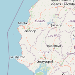
Map view of Refugio de Vida Silvestre Samama Mumbes

Use this park location map to pinpoint Refugio de Vida Silvestre Samama Mumbes in Ecuador, understand its exact geographic position, and read its mapped placement within the surrounding landscape more clearly.

Pigeon | © OpenStreetMap contributors

Location context for Refugio de Vida Silvestre Samama Mumbes

BolívarLos Rios
Park atlas

Compare adjacent Andean foothills, lowland forests, and regional conservation landscapes

Parks Near Refugio de Vida Silvestre Samama Mumbes and Surrounding Protected Areas

Browsing other protected areas near Refugio de Vida Silvestre Samama Mumbes reveals connected ecological corridors along the western Andean slopes. Expanding the regional park comparison provides broader geographic context for tropical foothill forests and watershed habitats.
A soft watercolor painting of a hilly, grassy landscape with distant mountains in muted greens and pinks.
Wildlife reserveChimborazo
About 46 km away#1 closest

East

Reserva de Producción de Fauna Chimborazo: Volcanic Landscapes and Andean Wildlife Reserve

High-altitude watershed and páramo geography in central Ecuador.

Spanning from glacial summits to arid puna plains, the Reserva de Producción de Fauna Chimborazo represents a complex Andean ecosystem. This wildlife reserve protects vital watersheds, glacial meltwater sources, and native camelid habitats within the shadows of Ecuador's tallest peaks, offering a detailed look at high-altitude conservation and volcanic terrain.

Area
526.83 km²
Established
1987
IUCN
IV
Relief
Mountain
A wide watercolor illustration showing a misty landscape with green trees in the midground and faint mountain peaks in the background.
Nature reserveEcuador
About 69 km away#2 closest

North

Reserva Ecológica Los Illinizas: Geographic Atlas and Andean Protected Nature Reserve

Volcanic terrain and cloud forest ecosystems in central Ecuador

Spanning across the provinces of Cotopaxi, Pichincha, and Santo Domingo de los Tsáchilas, Reserva Ecológica Los Illinizas preserves a significant vertical gradient of Andean ecosystems. The reserve protects the western flanks of the Illiniza volcanoes, Quilotoa, and El Corazón, offering a detailed look at high-altitude biodiversity and the transition from rugged mountain peaks to lush western cloud forests.

Area
1,342.33 km²
Established
1996
IUCN
Ia
Relief
Mountain
A pale, soft watercolor painting showing a stylized, rolling landscape with light green, pink, and yellow hues representing hills and trees.
Nature reserveGuayas Province
About 86 km away#3 closest

Southwest

Reserva ecológica Manglares Churute: Mapping a Coastal Nature Reserve in Guayas Province

An ecological mosaic of mangrove forests, estuaries, and forested ridges.

Spanning from the inner Gulf of Guayaquil into the Churute hill range, Reserva ecológica Manglares Churute acts as an essential protected area within Ecuador. The region contains one of the country's most significant mangrove complexes, complemented by freshwater lagoons and unique fog-affected forest summits that support diverse wildlife populations and endemic vegetation.

Area
471.74 km²
Established
1979
IUCN
Ia
Relief
Mixed relief
Nature reserveGuayas
About 88 km away#4 closest

Southwest

Bosque Protector La Prosperina Nature Reserve and Coastal Ecuador Forest Geography

Protected dry forest habitat and regional geographic terrain

Bosque Protector La Prosperina represents a critical survival of Ecuador's equatorial dry forest within the Guayas province. This nature reserve offers deep insight into seasonal ravine networks, drought-adapted vegetation, and the structural dynamics of fragmented coastal landscapes near Guayaquil.

Area
2.424 km²
Established
1994
Relief
Upland
Climate
Tropical
Wildlife reserveGuayas
About 94 km away#5 closest

Southwest

Reserva de producción de fauna Manglares El Salado: Coastal Geography and Protected Lands

A mangrove-dominated wildlife reserve in Guayas, Ecuador.

Analyze the protected landscape of Reserva de producción de fauna Manglares El Salado, which spans extensive mangrove forests and estuarine waters within the Guayas province. This wildlife reserve showcases a unique transition between intertidal mangrove zones, salt flats, and remnants of tropical dry forest, providing essential habitat context for the Gulf of Guayaquil coastal region.

Area
53.09 km²
Established
2002
IUCN
VI
Relief
Lowland
A horizontal watercolor painting showing a stylized forest landscape with soft pastel green, yellow, and pink hues representing trees and rolling hills.
Protected areaGuayas
About 95 km away#6 closest

Southwest

Bosque Protector Cerro Blanco: Protected Area and Tropical Dry Forest Geography in Guayas

Mapped terrain of the Chongon-Colonche mountain range

Bosque Protector Cerro Blanco functions as a major conservation site in coastal Ecuador, protecting rare Tumbesian forest ecosystems within the Guayas province. The reserve features diverse topography of ridges and valleys, serving as a critical buffer for regional endemic species and offering a unique look at seasonally dry forest landscapes near Guayaquil.

Area
60.78 km²
Established
1992
Visitors
12K annual
Relief
Upland
Watercolor illustration showing a mountain landscape with a snow-capped peak, a lake, and green hills.
National parkEcuador
About 95 km away#7 closest

East

Sangay National Park: Ecuador's National Park for Mapped Landscape and Geographic Discovery

Explore Ecuador's protected area boundaries and regional terrain.

Sangay National Park serves as a crucial protected landscape within Ecuador, offering rich opportunities for atlas and geography exploration. This page details the park's specific mapped boundaries and its natural terrain, providing essential context for understanding its place within South America's broader geographic tapestry. Investigate Sangay National Park's identity as a protected national park and its value for focused landscape and regional discovery.

Area
5,177.65 km²
Established
1979
IUCN
II
National parkEcuador
About 107 km away#8 closest

Northeast

Llanganates National Park: Detailed Atlas Entry for Ecuador's Protected Landscape

Explore the mapped geography and regional context of this Ecuadorian national park.

Llanganates National Park is a designated national park offering rich opportunities for geographic and landscape exploration. As a significant protected area in Ecuador, it provides crucial context for understanding the country's natural terrain and the distribution of its conservation landscapes. This entry is designed to facilitate an atlas-style discovery of the park's location, boundaries, and its role within the broader geography of the region.

Area
2,197.07 km²
Established
1996
IUCN
II
Relief
Mountain

Common questions about visiting, size, designation, and location context for Refugio de Vida Silvestre Samama Mumbes

Refugio de Vida Silvestre Samama Mumbes FAQs for park facts, access, geography, and protected area context

Find quick answers about Refugio de Vida Silvestre Samama Mumbes, including protected-area facts, park geography, trail and visitor context, and how the park fits into its surrounding country and regional landscape.
MoriAtlas Explorer

Continue Your Protected Areas Search Across the Global Atlas

Deepen your exploration by continuing the structured search for national parks and protected areas worldwide. Utilize the comprehensive filtering capabilities to compare different conservation landscapes and refine your understanding of global park geography. Discover more about the distribution and characteristics of protected natural areas.

Global natural geography