Mori Atlas logo
National parkSangay National Park

Discover the mapped terrain and regional context of this vital national park in South America.

Sangay National Park: Ecuador's Protected Landscape for Geographic and Atlas Exploration

(Parque Nacional Sangay)

Sangay National Park in Ecuador represents a significant protected landscape within the South American atlas. This page provides detailed geographic context, focusing on its mapped boundaries and the natural terrain that defines this national park. Users can explore the specific regional setting of Sangay National Park, understanding its contribution to Ecuador's protected areas and gaining insights valuable for landscape and geography-focused discovery.

Volcanic LandscapePáramo EcosystemUNESCO World Heritage SiteCloud ForestAndean MountainsActive Volcanoes
Illustration of a snow-capped mountain with green forests and valleys under a pastel sky

Sangay National Park

National park

Park overview

Structured park overview, official facts, and landscape profile for Sangay National Park

Sangay National Park park facts, protected area profile, and essential visitor context
Review the core facts for Sangay National Park, including designation, size, terrain, visitor scale, habitats, and operating context in one park-focused overview.

About Sangay National Park

Sangay National Park represents one of the most ecologically significant protected areas in tropical South America, a place where the raw power of volcanic activity meets extraordinary biological diversity. Straddling the central highlands of Ecuador across five provinces, the park encompasses an astonishing topographical range that traverses from the Amazonian foothills through Andean cloud forests to the windswept heights of glacial environments. The park's defining geographical features include two active stratovolcanoes, Tungurahua and Sangay, whose persistent activity has shaped the landscape over millennia, creating fertile volcanic soils that support lush vegetation communities. The third major volcanic peak, El Altar (known locally as Kapak Urku), stands as an extinct giant, its crater forming a distinctive horseshoe-shaped caldera visible from the surrounding highlands. This volcanic trilogy creates a landscape of profound geological interest while the elevation gradient spanning over 4,400 meters enables remarkable habitat diversity within a single protected boundary. The park's wetland system, fed by 327 lakes, represents one of the most extensive high-altitude wetland complexes in Ecuador, providing critical habitat for migratory waterfowl and serving essential hydrological functions for communities downstream. The páramo ecosystems within Sangay constitute some of the largest and best-preserved examples of this unique Andean biome, characterized by cushion plants, tussock grasses, and specialist species adapted to the harsh conditions of high elevation.

Quick facts and research context for Sangay National Park

Sangay National Park covers 5,177.65 square kilometers in Ecuador's Andean region, protecting a dramatic vertical gradient from tropical rainforests through cloud forests and páramo grasslands to glacial environments. The park contains three volcanic peaks, including active Tungurahua and Sangay volcanoes, and shelters over 3,000 plant species, 430 bird species, and 107 mammal species. It was inscribed on the UNESCO World Heritage List in 1983 and was briefly listed as endangered from 1992 to 2005 due to poaching, grazing pressure, and encroachment issues that have since been addressed.

Park context

Deeper park guide and search-rich context for Sangay National Park

Sangay National Park history, landscape, wildlife, and travel context
Explore Sangay National Park through its history, landscape character, ecosystems, wildlife, conservation priorities, cultural context, and seasonal travel timing in a structured park guide built for atlas discovery and search intent.

Why Sangay National Park stands out

Sangay is renowned for its remarkable volcanic landscape, featuring two perpetually active volcanoes within a protected area, a geological rarity globally. The park protects one of the largest and most intact páramo ecosystems in the Andes, the high-elevation moorlands critical for water regulation and endemic biodiversity. Its exceptional altitudinal range creates a vertical spectrum of ecosystems from tropical rainforest to glaciers within a single protected area. The park serves as a vital refuge for endangered species including the mountain tapir and spectacled bear, and supports significant populations of Andean Condors and the distinctive Andean Cock-of-the-rock.

Snow-capped volcano peak with forested slopes and clouds under a blue sky
Western slope of Sangay volcano with snow-capped peak and forested lower slopes under a partly cloudy sky

Sangay National Park history and protected-area timeline

Sangay National Park was established in 1979 as part of Ecuador's expanding network of protected areas during a period of growing environmental consciousness in the country. The park's outstanding universal value was recognized internationally in 1983 when it was inscribed as a UNESCO World Heritage Site, becoming one of the earliest Latin American protected areas to receive this designation. The inscription acknowledged the park's exceptional combination of natural phenomena, including its volcanic landscape, biodiversity, and the ecological processes occurring across its altitudinal gradient. In 1992, Sangay was added to the List of World Heritage in Danger due to mounting pressures from illegal poaching, extensive grazing by domestic livestock, unplanned road construction, and encroachment along the park's perimeter. These threats reflected the challenges facing many developing-world protected areas where traditional land uses and population pressures create ongoing management tensions. Through strengthened conservation efforts and improved boundary management, the park was removed from the endangered list in 2005, representing a successful example of international collaboration and improved park management. The park's name derives from the Shuar indigenous language, originating from the word "samkay" meaning "volcano," reflecting the deep cultural connections between the landscape and the indigenous peoples who have inhabited this region for centuries.

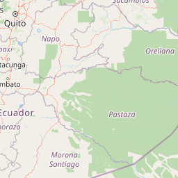
Sangay National Park landscape and geographic character

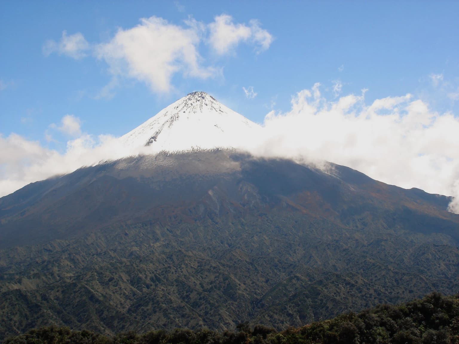
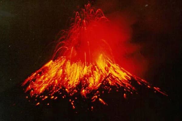
The physical landscape of Sangay National Park is dominated by volcanic geology, with three major volcanic complexes defining the terrain's character and visual identity. Tungurahua, a persistently active stratovolcano, rises to 5,023 meters and has experienced numerous significant eruptions in recent decades, including major explosions in 1999 and 2016 that deposited ash across surrounding communities. Sangay volcano, standing at 5,230 meters, represents one of the most active volcanoes in the world, with continuous Strombolian eruptions visible from the park's higher elevations. The extinct El Altar volcano, reaching 5,319 meters, forms a spectacular horseshoe-shaped caldera with nine peaks surrounding an internal crater lake, creating one of the most photographed landscapes in Ecuador's highlands. Between these volcanic peaks, the terrain drops through dramatic valleys carved by glacial processes and subsequent fluvial erosion, creating a landscape of steep ravines, cascading waterfalls, and U-shaped valleys characteristic of past glaciation. The park's lower elevations feature the rolling hills and forested slopes that mark the transition toward the Amazon basin, while the higher elevations present the stark, windswept terrain of the páramo with its distinctive cushion vegetation and alpine meadows.

Volcanic eruption showing bright orange lava flows and red ash plume against dark sky
Strombolian eruption of Tungurahua Volcano with lava flows and ash plume

Sangay National Park ecosystems, habitats, and plant life

The ecological diversity within Sangay National Park stems directly from its extraordinary altitudinal range, which encompasses multiple distinct biomes within a relatively compact territory. The tropical rainforests of the lower elevations, below approximately 1,500 meters, represent the northern extension of Amazonian forests, characterized by high species diversity, lianas, and evergreen canopies. Rising through the slopes, cloud forests develop where persistent mist and fog maintain high humidity, supporting epiphytes, ferns, and a specialized community of moisture-dependent species. The páramo zone, beginning around 3,500 meters, represents one of the most distinctive Andean ecosystems, adapted to the cold, windy conditions and seasonal water availability. This high-elevation biome features plants with growth forms specifically adapted to survive freezing temperatures, including cushion plants and bunch grasses that create the characteristic patchwork patterns visible across the landscape. The wetland system comprising 327 lakes and extensive marshlands provides critical habitat diversity, supporting species adapted to aquatic environments within the broader terrestrial matrix.

Sangay National Park wildlife and species highlights

Sangay National Park supports an exceptional concentration of wildlife, with over 430 bird species, 107 mammal species, 33 amphibian species, 14 reptile species, and 17 fish species documented within its boundaries. The park provides crucial habitat for two of the Andes' most emblematic endangered mammals: the mountain tapir, the largest terrestrial mammal in South America and the park's most significant conservation priority, and the spectacled bear, the continent's only bear species, which inhabits the forested lower elevations. The predator community includes jaguar, cougar, ocelot, and margay, representing a full suite of Neotropical felids. Wetland areas support populations of giant otter, while the streams and rivers harbor populations of endangered fish species. The bird fauna is particularly remarkable, with the park recognized as an Important Bird Area by BirdLife International. The Andean Condor, one of the world's largest flying birds, soars above the park's higher elevations, while the Andean Cock-of-the-rock, with its brilliant red plumage, inhabits the forested slopes. The park has also been the site of significant recent scientific discoveries, including the description of Caenolestes sangay, a new species of shrew opossum, in 2013 and the frog Pristimantis tinguichaca from cloud forest habitats in 2016.

Sangay National Park conservation status and protection priorities

Sangay National Park holds significant conservation importance as one of the most biodiverse protected areas in the Andes and a critical component of Ecuador's national protected area network. The park's UNESCO World Heritage designation recognizes its outstanding universal value as a natural site of significance that transcends national boundaries. The páramo ecosystems within Sangay represent crucial water Catchment areas, providing hydrological services to millions of people in the surrounding provinces, making the park's conservation important for both biodiversity and human welfare. The mountain tapir population in Sangay represents one of the most significant remaining strongholds for this endangered species, making the park globally important for its conservation. The successful resolution of the threats that led to the park's endangered status between 1992 and 2005 demonstrates the effectiveness of improved management and international attention, though ongoing vigilance remains essential as pressures from surrounding communities and development continue to evolve.

Sangay National Park cultural meaning and human context

The landscape of Sangay National Park holds deep significance for the indigenous Shuar people, whose language gave the park its name. The Shuar term "samkay," meaning volcano, reflects the central place that these volcanic peaks hold in indigenous cosmology and traditional land use. The park spans traditional territories that have been inhabited for centuries, with the Shuar and other indigenous communities maintaining cultural connections to the landscape even as the area has been designated as a protected area. The park's establishment represents a balance between conservation objectives and the recognition of indigenous peoples' relationships with the land, though the implementation of protected area management has required ongoing dialogue with local communities. The highland communities surrounding the park maintain traditional agricultural practices that interact with the park's boundaries, creating both management challenges and opportunities for community-based conservation approaches.

Top sights and standout views in Sangay National Park

The defining highlight of Sangay National Park remains its volcanic trio: the active Tungurahua and Sangay volcanoes providing ongoing geological drama while the extinct El Altar offers a spectacular hiking destination with its nine-peaked crater rim. The park's páramo ecosystems represent some of the finest high-altitude grassland environments in the Andes, with the characteristic cushion vegetation creating surreal landscapes that change with the light throughout the day. Wildlife viewing opportunities include the chance to encounter mountain tapirs in the higher forest zones and Andean Condors soaring on thermal currents above the volcanic slopes. The 327 lakes scattered throughout the park offer fishing, birdwatching, and scenic beauty, particularly the crater lake within El Altar's caldera. The vertical diversity allows visitors to experience multiple ecosystems in a single visit, from tropical forest trails to alpine meadow walks.

Best time to visit Sangay National Park

The optimal time to visit Sangay National Park depends on the specific activities planned, though the dry season from June to September generally offers the most reliable conditions for trekking and wildlife viewing in the highland areas. The park experiences a marked wet season from October through May, when páramo trails can become muddy and visibility in the higher elevations may be reduced by cloud cover. The active volcanoes are best observed during clear weather periods, typically in the drier months, though Tungurahua's activity can create atmospheric effects at any time. Birdwatching remains productive throughout the year, though the wet season brings migratory species to the wetland areas. The shoulder seasons of May-June and September-October may offer favorable conditions with fewer visitors while still providing reasonable weather. Temperature extremes vary dramatically with elevation, so visitors planning to explore the full altitudinal range should prepare for conditions ranging from tropical warmth to freezing alpine winds.

Park location guide

Geography guide, regional context, and park location map for Sangay National Park

Sangay National Park park geography, regions, and map view in Ecuador
Understand where Sangay National Park sits in Ecuador through a broader geographic reading of the surrounding landscape, nearby location context, and its mapped position within the national park landscape.

How Sangay National Park fits into Ecuador

Ecuador is a presidential republic located in northwestern South America, with Quito as its capital and Guayaquil as its largest city. The country spans 283,561 km² and encompasses the Galápagos Islands, a volcanic archipelago famous for unique wildlife that helped shape Darwin's theory of evolution. Ecuador is a plurinational state with Spanish as the official language, though Kichwa and Shuar are recognized for indigenous peoples.

Wider geography shaping Sangay National Park in Ecuador

Ecuador is located in northwestern South America along the Pacific coast. It shares borders with Colombia to the north and Peru to the east and south. The country includes the Galápagos Islands, a volcanic archipelago in the Pacific Ocean approximately 1,000 km west of the mainland. The territory encompasses diverse terrain including the Amazon rainforest in the east, the Andean highlands in the center, and coastal plains along the Pacific.

Map view of Sangay National Park

Use this park location map to pinpoint Sangay National Park in Ecuador, understand its exact geographic position, and read its mapped placement within the surrounding landscape more clearly.

Pigeon | © OpenStreetMap contributors

Location context for Sangay National Park

Azuay ProvinceCañar ProvinceChimborazo ProvinceMorona-Santiago ProvinceTungurahua Province

Visual Guide to Sangay National Park's Diverse Habitats, Volcanic Peaks, and High-Altitude Ecosystems

Sangay National Park Photos: Explore Volcanic Landscapes and Andean Páramo Scenery
Visually explore the dramatic terrain and diverse ecosystems of Sangay National Park, a UNESCO World Heritage Site in Ecuador, through compelling protected-area imagery. This collection offers crucial insights into the park's active volcanoes, expansive páramo, and unique high-altitude habitats, deepening understanding of its geographic identity and conservation value.

Snow-capped volcano peak with forested slopes and clouds under a blue sky

Aerial view of a snow-capped volcano with an ash plume rising from the summit, surrounded by clouds

Volcanic eruption showing bright orange lava flows and red ash plume against dark sky

Park atlas

Explore the geographic context and connected protected landscapes across the Andes beyond Sangay National Park.

Compare Related Protected Areas and National Parks Near Sangay National Park
Browse a curated selection of national parks and other protected areas geographically connected to Sangay National Park, tracing Ecuador's diverse Andean ecosystems. Compare these vital conservation landscapes to understand regional protected area spread, volcanic terrain features, and high-altitude páramo habitats.
National parkEcuador

Llanganates National Park: Detailed Atlas Entry for Ecuador's Protected Landscape

Explore the mapped geography and regional context of this Ecuadorian national park.

Llanganates National Park is a designated national park offering rich opportunities for geographic and landscape exploration. As a significant protected area in Ecuador, it provides crucial context for understanding the country's natural terrain and the distribution of its conservation landscapes. This entry is designed to facilitate an atlas-style discovery of the park's location, boundaries, and its role within the broader geography of the region.

Area
2,197.07 km²
Established
1996
IUCN
II
Relief
Mountain
National parkCotopaxi Province

Cotopaxi National Park: Ecuador's Mapped Protected Landscape and Regional Geography

Explore the geographic context of this national park.

Cotopaxi National Park represents a key protected landscape within Ecuador, located in Cotopaxi Province. This page facilitates detailed exploration of the park's mapped boundaries and its contribution to the regional geography. Understand the specific characteristics of this national park as part of a broader atlas of protected areas and natural terrains.

Area
333.93 km²
Established
1975
IUCN
II
Relief
Mountain
National parkEcuador

Sumaco Napo-Galeras National Park: Ecuador's Volcanic National Park Landscape

Explore protected areas and biodiversity in the Andean-Amazon transition.

Sumaco Napo-Galeras National Park protects a dramatic volcanic landscape in Ecuador, showcasing a significant elevation gradient that supports diverse cloud forest and Amazonian rainforest habitats. This national park is recognized for its endemic species and rich avifauna, offering a compelling case study for understanding protected land geography and ecological transitions within South America.

Area
2,067.49 km²
Established
1994
IUCN
II
Relief
Mountain
National parkManabí Province

Machalilla National Park: Protected Area and Geographic Context in Manabí Province

Explore mapped natural landscapes and regional geography.

Delve into Machalilla National Park, a protected national park situated in Ecuador's Manabí Province. This page provides a focused view on its protected landscape character, emphasizing its geographic setting and mapped natural terrain. Understand how Machalilla National Park fits into the regional geography, offering a distinct case study for protected-area discovery and landscape atlas exploration.

Area
750.59 km²
Established
1979
IUCN
II
National parkEcuador

Yasuní National Park: Ecuador's Protected Landscape and Geographic Atlas Entry

Explore the mapped boundaries and regional terrain of this key national park.

Delve into the atlas-level details of Yasuní National Park, Ecuador's designated national park. This entry provides essential geographic context, focusing on the park's mapped boundaries and its role as a protected landscape within the region. Understand the specific terrain and protected area distribution that makes Yasuní National Park a significant point of geographic interest for atlas exploration.

Area
10,227.4 km²
Established
1979
IUCN
II
Relief
Lowland
National parkEcuador

Podocarpus National Park: Ecuador's Diverse National Park and Protected Landscape

Discover elfin forests, paramo, and over 100 lagoons.

Podocarpus National Park, situated in southeastern Ecuador, stands as a prime example of a protected natural area at a unique biogeographic crossroads. This national park spans dramatic elevational zones, from montane rain forests to high-elevation paramo ecosystems dotted with more than 100 lagoons, offering rich mapped landscape exploration. Its significance lies in the convergence of four distinct ecological systems, contributing to exceptional biodiversity and a rich tapestry of natural terrain.

Area
1,462.8 km²
Established
1982
IUCN
II
Relief
Mountain
National parkZamora Chinchipe

Yacurí National Park: Protected Andean Lakes and Volcanic Landscape in Zamora Chinchipe

Discover highland geography and the ancient Inca Trail.

Yacurí National Park is a key protected landscape in Ecuador's southern Andes, celebrated for its remarkable collection of over 46 high-altitude lakes set within dramatic volcanic terrain. Situated in Zamora Chinchipe province, the park preserves a vital stretch of the Inca Trail, complete with archaeological sites. This national park offers a rich exploration of Andean geography, páramo ecosystems, and significant cultural heritage, making it a cornerstone of the region's protected areas.

Area
431 km²
Established
2009
IUCN
II
Relief
Mountain
National parkPeru

Cerros de Amotape National Park: Peru's Protected Pacific Tropical Forest Atlas

Explore mapped boundaries and diverse terrain of this unique landscape.

Cerros de Amotape National Park stands as a significant protected area within Peru, meticulously preserving remnants of the Tumbes-Piura dry forests and Pacific tropical forests. Situated within the Cordillera de los Amotapes, the park features a dynamic landscape from riverine habitats to elevated mountain terrain. This park detail page offers an atlas-style view, focusing on its geographic context, mapped protected boundaries, and its importance as a conservation corridor for unique biodiversity.

Area
1,515.61 km²
Established
1975
IUCN
II
Relief
Mountain

Common questions about visiting, size, designation, and location context for Sangay National Park

Sangay National Park FAQs for park facts, access, geography, and protected area context
Find quick answers about Sangay National Park, including protected-area facts, park geography, trail and visitor context, and how the park fits into its surrounding country and regional landscape.
MoriAtlas Explorer

Continue Your Protected Areas Search Across the Global Atlas

Deepen your exploration by continuing the structured search for national parks and protected areas worldwide. Utilize the comprehensive filtering capabilities to compare different conservation landscapes and refine your understanding of global park geography. Discover more about the distribution and characteristics of protected natural areas.

Global natural geography