

Mori Atlas logo
Nature reserveReserva Ecológica Los Illinizas

A vertical continuum of volcanic peaks, páramo ecosystems, and biodiverse montane cloud forests

Reserva Ecológica Los Illinizas: Analyzing the Protected Landscape and Andean Terrain in Ecuador

(Reserva Ecológica Los Illinizas (RELI))

Reserva Ecológica Los Illinizas protects a critical Andean landscape in Ecuador, stretching from the high-elevation twin peaks of the Illiniza volcanoes down through steep, forested western slopes. This protected area serves as a vital corridor for endemic Chocó biodiversity, bridging the gap between high-altitude páramo grasses and lower-elevation cloud forests. Through detailed mapping and geographic analysis, the area reveals a complex mosaic of intact volcanic terrain, secondary forest recovery, and community-managed conservation zones.

andean ecologyvolcanic landscapeparamomontane cloud forestprotected natural areaImportant Bird and Biodiversity Area
A stylized illustration showing snow-capped mountain peaks rising above green rolling hills and forests under a pale sky.

Reserva Ecológica Los Illinizas

Nature reserve

Park overview

Structured park overview, official facts, and landscape profile for Reserva Ecológica Los Illinizas

Reserva Ecológica Los Illinizas park facts, protected area profile, and essential visitor context

Review the core facts for Reserva Ecológica Los Illinizas, including designation, size, terrain, visitor scale, habitats, and operating context in one park-focused overview.

About Reserva Ecológica Los Illinizas

The Reserva Ecológica Los Illinizas occupies a strategically important position on the western escarpment of the Ecuadorian Andes, where the cordillera drops steeply from snow-capped volcanic summits to the more humid forests of the Pacific slope. At its upper elevation, the reserve includes the western flanks of the Illiniza twin volcanoes and adjacent volcanic terrain associated with Quilotoa and El Corazón. These high zones are characterized by open páramo ecosystems, exposed volcanic substrates, and dramatic elevation shifts over short horizontal distances.

Descending from the páramos, the reserve transitions into montane and cloud forest formations, where persistent moisture supports a dense cover of broadleaf trees covered in epiphytes, mosses, and a high diversity of understory plants. The Bosque Integral Otonga, located in the northern portion of the reserve area in the canton of Sigchos, is a particularly important stronghold of this lower forest habitat, containing primary forest, secondary growth, regenerating pastures, and both lower montane evergreen forest and cloud forest types.

The ecological reserve is also defined by its mosaic of governance. While the core area is administered by Ecuador's Ministry of Environment as a strict nature reserve, additional forest areas such as Reserva Forestal Río Lelia and the Huagrahuasi-Quitasol protective forest are managed with the participation of local cooperatives, family associations, and conservation NGOs. This blend of strict state protection and community-based stewardship distinguishes the reserve from many neighboring Andean protected areas and shapes much of its conservation landscape today.

Quick facts and research context for Reserva Ecológica Los Illinizas

Reserva Ecológica Los Illinizas is a large IUCN Category Ia strict nature reserve located in the central Ecuadorian Andes and administered by Ecuador's Ministry of Environment. It lies along the western cordillera and includes the twin volcanic peaks of Illiniza, the volcanic areas of Quilotoa and El Corazón, and a gradient of ecosystems running from high-altitude páramos down through montane cloud forests toward the western lowlands of the country.

The reserve was established through an interministerial agreement in December 1996 and spans portions of the provinces of Cotopaxi, Pichincha, and Santo Domingo de los Tsáchilas. It is recognized internationally as an Important Bird and Biodiversity Area and is closely associated with complementary protected and community-managed forest reserves, including the Bosque Integral Otonga and the Huagrahuasi-Quitasol protective forest.

Protection and recognition

Documented terrestrial protection scope and international recognition facts

Reserva Ecológica Los Illinizas Protection Status and Recognition Data

Reserva Ecológica Los Illinizas maintains a documented terrestrial protection scope within the regional conservation network. Structured facts outline administrative management parameters and international recognition records without additional designation claims.

Protection details

Protection scope
Terrestrial
Transboundary protection
No
Park context

Deeper park guide and search-rich context for Reserva Ecológica Los Illinizas

Reserva Ecológica Los Illinizas history, landscape, wildlife, and travel context

Explore Reserva Ecológica Los Illinizas through its history, landscape character, ecosystems, wildlife, conservation priorities, cultural context, and seasonal travel timing in a structured park guide built for atlas discovery and search intent.

Why Reserva Ecológica Los Illinizas stands out

The reserve is best known for protecting the western flanks of the Illiniza volcanoes, a striking Andean landscape where high-altitude páramos transition into exceptionally biodiverse montane cloud forests. The lower forested zones, especially around the Bosque Integral Otonga, harbor a rich concentration of endemic and globally threatened Chocó birds, rare mammals such as the spectacled bear, and a notable herpetofauna that has drawn scientific attention in recent years. Equally distinctive is the integration of strict nature protection with active community-based land management, as cooperative and family-run initiatives sustain páramo use, forest recovery, and small protected forest reserves within the broader ecological landscape.
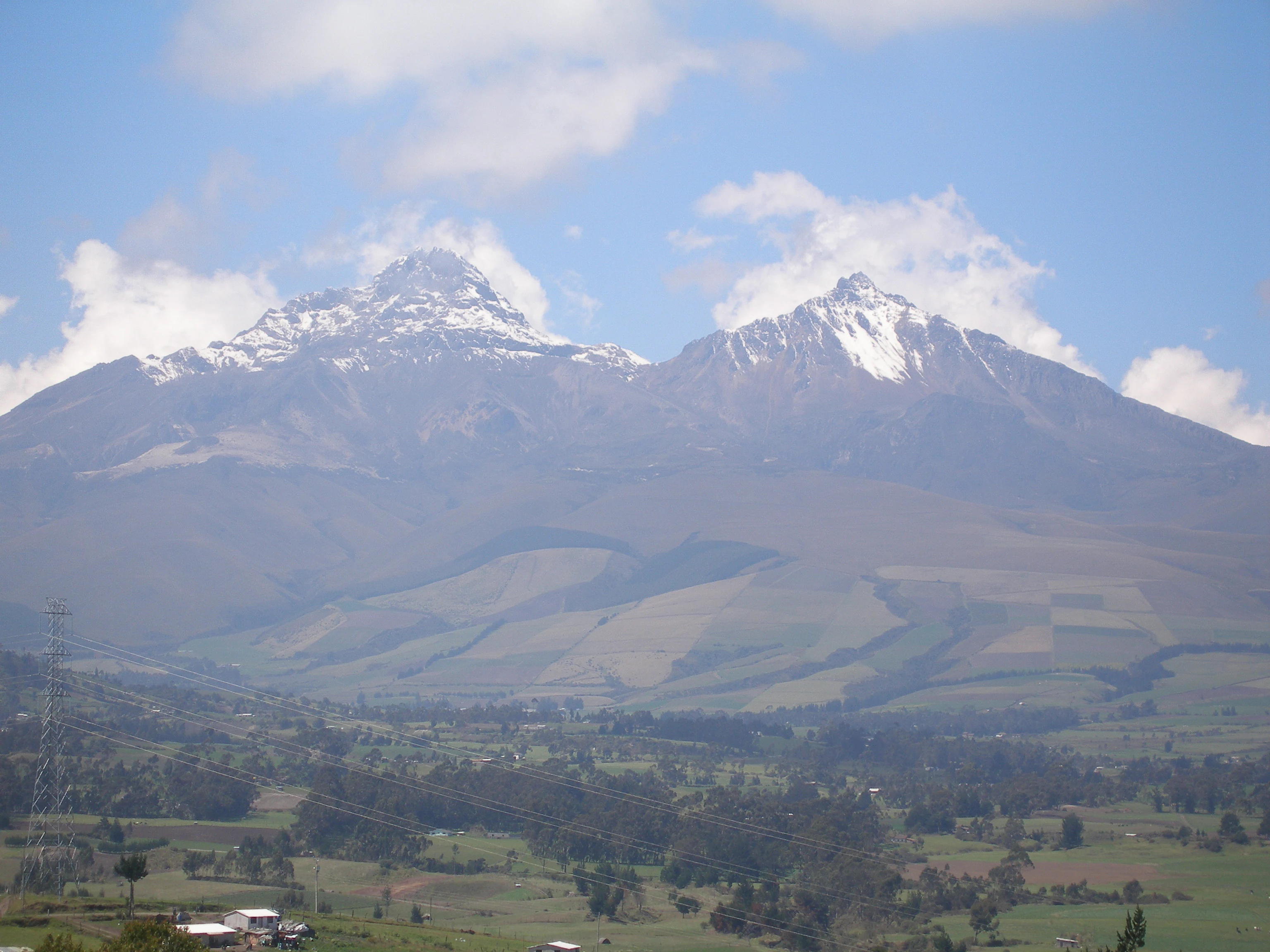
Two large snow-capped mountain peaks rising above a green agricultural valley with scattered trees and buildings under a blue sky with clouds.
View of the snow-capped Illinizas mountains rising above a green agricultural valley in Ecuador.

Reserva Ecológica Los Illinizas history and protected-area timeline

The Reserva Ecológica Los Illinizas was formally established on 11 December 1996 through interministerial agreement number 066, published in the Official Registry on 19 December 1996. The reserve was created to conserve a representative section of the western Andean ecosystems of central Ecuador, encompassing the Illiniza volcanic complex and its associated páramo, cloud forest, and lower montane habitats.

From its inception, the ecological reserve was conceived not as an isolated protected block but as part of a wider conservation landscape. Adjacent community-managed forests and NGO-supported reserves, including the Bosque Integral Otonga established through cooperation between the Otonga Foundation and the Tapia family, were already evolving alongside it. The cooperative Cotopilaló and the Asociación Huahuauco-La Merced have similarly played a long-standing role in managing the Huagrahuasi-Quitasol protective forest as a buffer to the core reserve.

In parallel, a small forest area was acquired early on by an international coalition including the Zoological Society for Conservation of Species and Populations, Fundación Loro Parque, and Fonds für Bedrohten Papagaien for the specific purpose of conserving the critically endangered yellow-eared parrot. The reserve has since been recognized internationally by BirdLife International as an Important Bird and Biodiversity Area, formalizing its significance for the long-term survival of several restricted-range and threatened Andean and Chocó species.

Reserva Ecológica Los Illinizas landscape and geographic character

The landscape of Reserva Ecológica Los Illinizas is defined by sharp Andean topographic contrasts, rising from the volcanic high country of the central cordillera down to deeply dissected western slopes crossed by valleys descending toward the Pacific lowlands. The reserve's most conspicuous features are the Illiniza volcanoes, a paired massif presenting two distinct summits of markedly different elevation and character, flanked by the volcanic systems of Quilotoa to the south and El Corazón to the north.

At higher elevations, the terrain opens into broad stretches of páramo, where grassy pajonal vegetation covers ancient volcanic ash and rock above approximately 3,500 meters. These high zones are arid in appearance and exposed to strong winds yet sustain a delicate herbaceous flora adapted to harsh mountain conditions. Moving downslope, the landscape becomes increasingly steep and forested, with ridges and ravines hosting montane evergreen forest and, at lower altitudes, true cloud forest cloaked in mist and moisture.

In the northern portion of the reserve area, the Bosque Integral Otonga represents a particularly intricate landscape, where a mosaic of primary forest, regenerating vegetation, abandoned pastures, and agricultural fronts creates a fragmented but ecologically rich environment. Surrounding lowlands, though heavily altered, frame the reserve with sugarcane fields and pasturelands that emphasize the abrupt transition between intact Andean ecosystems and transformed agricultural landscapes.

Reserva Ecológica Los Illinizas ecosystems, habitats, and plant life

The Reserva Ecológica Los Illinizas encompasses a broad altitudinal gradient that produces a corresponding diversity of vegetation formations and ecological processes. At its upper limits, the reserve protects extensive high-Andean páramo communities dominated by tough pajonal grasses and interspersed cushion plants and shrubs, with characteristic species such as Buddleja incana, Myrsine andina, Oreopanax, Vallea stipularis, Gynoxys baccharoides, Hesperomeles heterophylla, Barnadesia arborea, Monnina obtusifolia, and Escallonia myrtilloides.

Below the páramo, the reserve's mid-elevation forests present small and increasingly fragmented remnants of native woodland alongside active recovery zones. These montane forests provide habitat for characteristic high-Andean trees and shrubs and serve as a transition zone between the open highlands and the denser forests below.

In the lower elevations, especially within the Bosque Integral Otonga, the reserve preserves particularly important montane cloud forest and lower montane evergreen forest systems. These forests are notable for their high abundance of epiphytes and contain valuable tree species such as Cedrela odorata, Otoba novogranatensis, Carapa guianensis, Nectandra obtusata, Myrcia splendens, Schweilera caudiculata, Croton magdalenensis, Ficus species, Cinchona, and Cecropia. The combination of intact primary forest, regenerating secondary vegetation, and recovering pastures gives this zone an especially dynamic ecological character.

Reserva Ecológica Los Illinizas wildlife and species highlights

Wildlife knowledge within the Reserva Ecológica Los Illinizas is uneven but increasingly detailed, particularly in the lower forested zones where focused studies have been conducted. In the Bosque Integral Otonga, research has documented more than fifty mammal species, including the spectacled bear, the puma, and the collared peccary, as well as a newly described rodent species, Heteromys teleus, highlighting the area's significance for mammalian diversity in the western Andes.

The reserve is also recognized for a notably rich herpetofauna, with an estimated forty species present and new insect species described from recent surveys. Frog, lizard, and salamander populations in the cloud forest understory are particularly important for understanding amphibian diversity along the western Ecuadorian slope.

The reserve stands out for its birdlife, especially in cloud forest localities such as Caripero. Endemic and globally threatened Chocó species documented in the area include the giant antpitta, the moustached antpitta, the cloud-forest pygmy owl, the hoary puffleg hummingbird, and the dark-backed wood quail. Caripero has also been the only recently known site in Ecuador for the critically endangered yellow-eared parrot, although the species has not been recorded there in recent years, underscoring both the reserve's conservation importance and the urgency of continued monitoring.

Reserva Ecológica Los Illinizas conservation status and protection priorities

The conservation significance of Reserva Ecológica Los Illinizas lies in its protection of an unusually complete vertical sequence of western Andean ecosystems, from high-altitude páramo through montane cloud forest to lower evergreen forest, a gradient under severe pressure elsewhere in Ecuador. The reserve's lower forests in particular are recognized as a refuge for endemic and globally threatened species of the Chocó biogeographic region, including rare birds, the spectacled bear, and a distinctive herpetofauna.

Internationally, the area has been recognized as an Important Bird and Biodiversity Area by BirdLife International, formalizing its role in the survival of restricted-range bird species along the western Andean slope. The early acquisition of forestland specifically to protect the yellow-eared parrot, an action undertaken by international zoos and conservation funds, marked one of the most notable targeted conservation efforts in the region.

Within Ecuador, the reserve also serves as a model for integrating strict state protection with community-led conservation and land recovery, through cooperative-managed forests like Huagrahuasi-Quitasol and NGO-supported private reserves such as Otonga. Recovery of abandoned pastures, preservation of páramo vegetation, and protection of remaining forest patches together represent an active conservation agenda aimed at maintaining ecological connectivity in a landscape otherwise heavily altered by agriculture and cattle-raising.

Reserva Ecológica Los Illinizas cultural meaning and human context

The Illinizas region sits within a deeply rooted Andean cultural landscape, where indigenous and mestizo communities have long managed páramo and forest resources for daily subsistence. The highland páramos are traditionally used for the extraction of firewood and the gathering of wild fruits such as mortiño, gualicón, and taxo, as well as for harvesting paja grasses used in roofing homes and animal enclosures.

Local cooperative organizations have become central to the cultural and land-use fabric of the reserve. The Cooperativa Cotopilaló and the Asociación Huahuauco-La Merced, formed largely by the children of earlier cooperative members, play a continued role in stewarding protective forests and in shaping how páramo and forest resources are shared within communities. Nearby valley towns such as Machachi, Latacunga, and Saquisilí remain closely connected to the reserve through everyday resource use, trade, and small-scale agriculture, reinforcing the reserve's importance as both a natural and a culturally embedded landscape.

Top sights and standout views in Reserva Ecológica Los Illinizas

The reserve protects a rare vertical continuum of western Andean ecosystems, from the high páramo around the Illiniza peaks down to exceptionally biodiverse montane cloud forests at lower elevations. This gradient makes it a key refuge for endemic and globally threatened species of the Chocó region, including several rare antpittas, the cloud-forest pygmy owl, the hoary puffleg, and the dark-backed wood quail.

Equally distinctive is the diverse and sometimes threatened mammal fauna recorded in the lower forests, including the spectacled bear, the puma, the collared peccary, and a newly described rodent species, alongside a rich herpetofauna. The reserve is also notable for combining strict state protection with community-based and NGO-supported conservation, integrating reserves like Otonga and Huagrahuasi-Quitasol into a broader Andean conservation landscape recognized internationally as an Important Bird and Biodiversity Area.

Best time to visit Reserva Ecológica Los Illinizas

The character of a visit to Reserva Ecológica Los Illinizas shifts significantly with altitude and season. The higher páramo zones around the Illiniza and El Corazón volcanoes tend to be clearest and most accessible during the drier months of the central Andes, when high-altitude hiking conditions are typically more stable, though cold temperatures and variable weather remain a constant feature of these elevations.

The lower cloud forest areas, particularly around the Bosque Integral Otonga, are influenced differently, receiving moisture throughout much of the year and often being shrouded in mist. Visits focused on birdwatching and the observation of cloud forest wildlife tend to benefit from periods of relative calm, while the wettest stretches can make lower trails more demanding. Across the reserve, weather is highly localized and can change rapidly with elevation, and conditions vary meaningfully between the arid southern sector near Quilotoa and the more humid northern forest zones.

Monthly climate preview

Long term temperature and precipitation records across representative coordinate sampling

Reserva Ecológica Los Illinizas Climate Normals and Annual Weather Patterns

Representative point measurements track the measured annual temperature rhythm alongside monthly precipitation values recorded between 1991 and 2020. Examining the complete twelve month profile provides deeper insight into sustained long term climate norms for Reserva Ecológica Los Illinizas.
Annual mean23 °C
23 °C24 °C
Jan23°
Feb23°
Mar23°
Apr23°
May23°
Jun23°
Jul23°
Aug24°
Sep24°
Oct24°
Nov24°
Dec23°
Warmest month
September

23.9 °C

Coolest month
June

22.7 °C

Wettest month
March

10 mm/day

Driest month
August

0.8 mm/day

Park location guide

Geography guide, regional context, and park location map for Reserva Ecológica Los Illinizas

Reserva Ecológica Los Illinizas park geography, regions, and map view in Ecuador

Understand where Reserva Ecológica Los Illinizas sits in Ecuador through a broader geographic reading of the surrounding landscape, nearby location context, and its mapped position within the national park landscape.

How Reserva Ecológica Los Illinizas fits into Ecuador

Ecuador is a presidential republic located in northwestern South America, with Quito as its capital and Guayaquil as its largest city. The country spans 283,561 km² and encompasses the Galápagos Islands, a volcanic archipelago famous for unique wildlife that helped shape Darwin's theory of evolution. Ecuador is a plurinational state with Spanish as the official language, though Kichwa and Shuar are recognized for indigenous peoples.

Wider geography shaping Reserva Ecológica Los Illinizas in Ecuador

Ecuador is located in northwestern South America along the Pacific coast. It shares borders with Colombia to the north and Peru to the east and south. The country includes the Galápagos Islands, a volcanic archipelago in the Pacific Ocean approximately 1,000 km west of the mainland. The territory encompasses diverse terrain including the Amazon rainforest in the east, the Andean highlands in the center, and coastal plains along the Pacific.

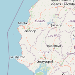
Map view of Reserva Ecológica Los Illinizas

Use this park location map to pinpoint Reserva Ecológica Los Illinizas in Ecuador, understand its exact geographic position, and read its mapped placement within the surrounding landscape more clearly.

Pigeon | © OpenStreetMap contributors

Location context for Reserva Ecológica Los Illinizas

CotopaxiPichinchaSanto Domingo de los Tsáchilas
Recorded earthquake history

Explore the Historical Earthquake Records for Reserva Ecológica Los Illinizas

Trace the history of recorded seismic activity within the vicinity of the reserve. This MoriAtlas catalogue provides a structured view of historical earthquake events, including magnitude and location metrics, to support geographic discovery of the surrounding Andean environment.

Reserva Ecológica Los Illinizas Earthquake History

Catalogued events

72 events

Strongest magnitude

Magnitude 6

Most recent event

Aug 16, 2025

This history includes earthquakes recorded inside the park or within 50 km of its borders

Visualizing the high altitude páramos and montane cloud forest habitats across volcanic terrain

Reserva Ecológica Los Illinizas Photos, Landscapes, and Andean Scenery

Visual records reveal the dramatic topographical shifts spanning from high volcanic summits down to mist-cloaked cloud forest habitats. Examining field photographs helps researchers and conservationists understand the rugged terrain and distinct environmental gradients of the protected region.

Two large snow-capped mountain peaks rising above a green agricultural valley with scattered trees and buildings under a blue sky with clouds.

A dirt path curves through a misty landscape of tall golden grasses and scattered green shrubs and trees.

Park atlas

Compare adjacent volcanic terrain and connected Andean ecosystems in the region

Parks Near Reserva Ecológica Los Illinizas and Surrounding Protected Areas

Browse other protected areas and national parks situated across the volcanic terrain surrounding Reserva Ecológica Los Illinizas. Comparing adjacent mountain ecosystems helps place high-altitude páramos and cloud forests into a broader regional geography context.
National parkCotopaxi Province
8.4 km away#1 closest

East

Cotopaxi National Park: Ecuador's Mapped Protected Landscape and Regional Geography

Explore the geographic context of this national park.

Cotopaxi National Park represents a key protected landscape within Ecuador, located in Cotopaxi Province. This page facilitates detailed exploration of the park's mapped boundaries and its contribution to the regional geography. Understand the specific characteristics of this national park as part of a broader atlas of protected areas and natural terrains.

Area
333.93 km²
Established
1975
IUCN
II
Relief
Mountain
A pale, minimalist watercolor painting showing a wide, grassy field leading to distant, low mountain hills under a bright, light sky.
Wildlife reservePichincha
About 16 km away#2 closest

Northeast

Refugio de Vida Silvestre Pasochoa: Volcanic Crater and Andean Forest Protected Area

Geographic atlas of the Pichincha volcanic highlands

Located in the Pichincha province, Refugio de Vida Silvestre Pasochoa protects an essential highland habitat defined by its steep volcanic crater walls and dense bamboo stands. This area provides a scientific reference for inter-Andean vegetation, featuring a sharp contrast between forested inner slopes and surrounding agricultural landscapes. Map the ecological gradient of this protected refuge and explore its role within the broader northern Andean geographic context.

Area
9.799 km²
Established
1996
IUCN
Ib
Relief
Mountain
A soft watercolor painting of a hilly, grassy landscape with distant mountains in muted greens and pinks.
Wildlife reserveChimborazo
30 km away#3 closest

South

Reserva de Producción de Fauna Chimborazo: Volcanic Landscapes and Andean Wildlife Reserve

High-altitude watershed and páramo geography in central Ecuador.

Spanning from glacial summits to arid puna plains, the Reserva de Producción de Fauna Chimborazo represents a complex Andean ecosystem. This wildlife reserve protects vital watersheds, glacial meltwater sources, and native camelid habitats within the shadows of Ecuador's tallest peaks, offering a detailed look at high-altitude conservation and volcanic terrain.

Area
526.83 km²
Established
1987
IUCN
IV
Relief
Mountain
National parkEcuador
35 km away#4 closest

Southeast

Llanganates National Park: Detailed Atlas Entry for Ecuador's Protected Landscape

Explore the mapped geography and regional context of this Ecuadorian national park.

Llanganates National Park is a designated national park offering rich opportunities for geographic and landscape exploration. As a significant protected area in Ecuador, it provides crucial context for understanding the country's natural terrain and the distribution of its conservation landscapes. This entry is designed to facilitate an atlas-style discovery of the park's location, boundaries, and its role within the broader geography of the region.

Area
2,197.07 km²
Established
1996
IUCN
II
Relief
Mountain
Watercolor illustration of a winding path through a green landscape with snow capped mountains in the distance against a pink sky.
National parkNapo
43 km away#5 closest

East

Parque nacional Antisana: Volcanic Terrain and Andean Protected Area Geography

High-altitude ecosystems spanning Napo and the Andean corridor

Spanning the rugged Cordillera Real, Parque nacional Antisana protects a vast sweep of volcanic terrain dominated by its central stratovolcano. From glacial fields to the water-retention capacity of its páramo wetlands, the area represents a crucial node in Ecuador's conservation network, providing a sanctuary for Andean condors and diverse montane species.

Area
1,205.81 km²
Established
1993
IUCN
Ia
Relief
Mountain
Biosphere reserveNapo
About 58 km away#6 closest

East

Reserva Biológica Colonso-Chalupas: Protected Landscapes of the Upper Napo Basin

A critical vertical corridor of the Ecuadorian Andes and Amazon.

Reserva Biológica Colonso-Chalupas represents a unique bioclimatic transition, stretching nearly 4,000 meters in elevation. This biosphere reserve serves as a functional corridor connecting high-altitude páramo and cloud forests to warm, humid Amazonian lowlands, forming a key structural element of the eastern Andean conservation landscape.

Area
931.63 km²
Established
2014
Relief
Mountain
Climate
Alpine
Watercolor illustration showing a panoramic view of a wide valley with green hills, a small stream, and forested clusters, rendered in a light and airy style.
Nature reservePichincha
About 62 km away#7 closest

Northeast

Reserva Geobotánica Pululahua: Protected Volcanic Caldera and Highland Ecosystems

A distinct geobotanical reserve in the Pichincha region of the Ecuadorian Andes.

Reserva Geobotánica Pululahua is a protected natural area centered on a massive, 12-kilometer-wide volcanic caldera. Its landscape features three prominent lava domes and a rare altitudinal gradient of vegetation, spanning from semi-dry mountain shrubland to dense cloud forest. This reserve serves as a critical study of volcanic geology and human-landscape interaction in the high Andes, offering a concentrated look at Ecuador's vertical ecological zonation.

Area
34.417 km²
Established
1966
Relief
Mountain
Climate
Subtropical
Wildlife reserveLos Rios
About 69 km away#8 closest

South

Refugio de Vida Silvestre Samama Mumbes: Foothill Forest and Protected Area Map

Mapping the western Andean slopes and Chocó forest fragments

Refugio de Vida Silvestre Samama Mumbes protects one of the final remnants of the Chocó Ecuatorial forest in the Ecuadorian Andes. This reserve encompasses steep, dissected ridges and vital river catchments, supporting endemic orchids, birds, and amphibians within a highly modified regional landscape. Gain deeper insight into its forest boundaries and watershed contribution.

Area
21.456 km²
Established
2016
IUCN
IV
Relief
Mountain

Common questions about visiting, size, designation, and location context for Reserva Ecológica Los Illinizas

Reserva Ecológica Los Illinizas FAQs for park facts, access, geography, and protected area context

Find quick answers about Reserva Ecológica Los Illinizas, including protected-area facts, park geography, trail and visitor context, and how the park fits into its surrounding country and regional landscape.
MoriAtlas Explorer

Continue Your Protected Areas Search Across the Global Atlas

Deepen your exploration by continuing the structured search for national parks and protected areas worldwide. Utilize the comprehensive filtering capabilities to compare different conservation landscapes and refine your understanding of global park geography. Discover more about the distribution and characteristics of protected natural areas.

Global natural geography