
Mori Atlas logo
Nature reserveRéserve naturelle nationale du val de Loire

Analyzing the protected fluvial corridors, shifting sandbanks, and alluvial forest geography

Réserve naturelle nationale du val de Loire: Mapping a Dynamic River Nature Reserve Landscape

The Réserve naturelle nationale du val de Loire stands as a premier example of a free-flowing river landscape, protecting a significant nineteen-kilometer stretch of the Loire in France. This protected area reveals a complex mosaic of gravel bars, side channels, and floodplain forests that are continuously reshaped by the river's natural rhythm. MoriAtlas offers a detailed look at this river corridor, providing insights into the alluvial habitats and the geomorphic forces that sustain its biodiversity.

river reserveloirefloodplain forestfree-flowing rivergravel barstern nesting
A stylized digital illustration of a wide, braided river with light-colored sandbars flowing between forested banks toward distant, rocky mountains under a soft sunset sky.

Réserve naturelle nationale du val de Loire

Nature reserve

Park overview

Structured park overview, official facts, and landscape profile for Réserve naturelle nationale du val de Loire

Réserve naturelle nationale du val de Loire park facts, protected area profile, and essential visitor context

Review the core facts for Réserve naturelle nationale du val de Loire, including designation, size, terrain, visitor scale, habitats, and operating context in one park-focused overview.

About Réserve naturelle nationale du val de Loire

The Réserve naturelle nationale du val de Loire is a national nature reserve straddling two French regions and two departments, anchored in the middle course of the Loire river. By protecting nineteen kilometers of the Loire and its immediate surroundings across 1,454 hectares, it captures a complete cross-section of the middle Loire landscape, the segment running roughly four hundred fifty kilometers from Nevers in the east to Angers in the west.

The reserve was created in 1995 in response to decades of recognition by local inhabitants, scientists, and naturalists that the exceptional character of this section of the Loire deserved formal protection. As the text of the original decree and supporting studies emphasized, the site is simultaneously the most representative middle Loire landscape and one of the best examples of an active fluvial dynamic still operating in Europe. The Loire here is not a fully controlled waterway; instead, it continues to erode, deposit, and rearrange its own banks, producing braided channels, shifting sandbars, and new islands.

Ecologically, the reserve acts as a continuous gradient from open water and gravel beaches through brushy zone known locally as "verdiaux" up into mature alluvial forest. This gradient supports approximately 620 plant species, representing about ten percent of the French flora, around 80 woody species in the floodplain woodland, more than 220 bird species including roughly 100 nesting species, and a wide range of fish, mammals, insects, and amphibians adapted to dynamic river conditions.

Quick facts and research context for Réserve naturelle nationale du val de Loire

The reserve protects 19 kilometers of the Loire river covering roughly 1,454 hectares across the Cher and Nièvre departments. Officially designated on 21 November 1995, it is managed jointly by the Conservatoires d'espaces naturels du Centre and de Bourgogne and is recorded under IUCN Category IV and WDPA ID 106726. The protected segment lies within the middle Loire, a stretch widely seen as the most representative example of the river's landscapes, flora, and fauna.

Protection and recognition

Terrestrial conservation designation history and official WDPA records

Réserve naturelle nationale du val de Loire Protection Status and Registry Data

Territorial protection status for Réserve naturelle nationale du val de Loire encompasses documented terrestrial management scope and conservation records. Official registry entries compile foundational designation data alongside verified international recognition sources.

Protection details

Protection scope
Terrestrial
Transboundary protection
No
WDPA ID
106726
Park context

Deeper park guide and search-rich context for Réserve naturelle nationale du val de Loire

Réserve naturelle nationale du val de Loire history, landscape, wildlife, and travel context

Explore Réserve naturelle nationale du val de Loire through its history, landscape character, ecosystems, wildlife, conservation priorities, cultural context, and seasonal travel timing in a structured park guide built for atlas discovery and search intent.

Why Réserve naturelle nationale du val de Loire stands out

The reserve is known above all for preserving one of the most representative stretches of free-flowing Loire landscape and for its role as a major migration corridor and breeding ground. Its gravel banks shelter nesting common and little terns, its floodplain forests include willow, black poplar, ash, elm, and oak, and its side channels host the European beaver. The site illustrates how an actively shifting river ecosystem can sustain exceptional biodiversity in the heart of western Europe.
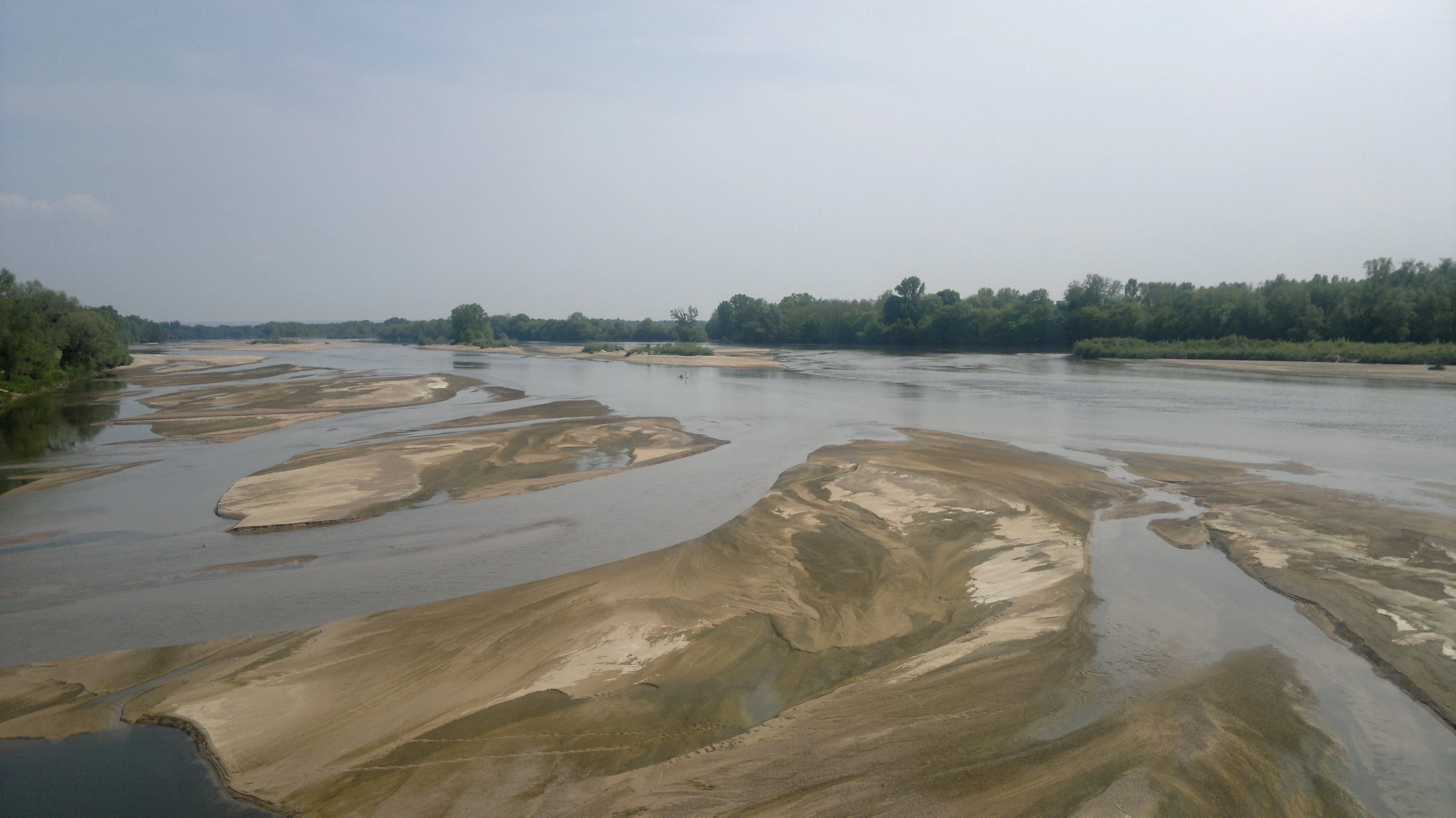
Wide angle view of the Loire River with numerous exposed sandbars and shallow water channels, framed by green trees on the banks under a hazy sky.
The Loire River, characterized by its wide, shallow channels and sandbars, flowing through the nature reserve near Pouilly-sur-Loire.

Réserve naturelle nationale du val de Loire history and protected-area timeline

Interest in this section of the Loire was already well established among local residents, river users, scientists, and naturalists long before the reserve existed. Their observations over many decades documented the exceptional quality of the middle Loire landscape here, both as a representative ecosystem and as one of the few large European rivers still genuinely shaped by its own hydrology. These findings formed the foundation of the formal conservation campaign that followed.

The reserve was formally classified on 21 November 1995 through a national decree, becoming one of the recognized national nature reserves of France. After its creation, management was entrusted to two regional conservatories of natural spaces, the Conservatoire d'espaces naturels du Centre and the Conservatoire d'espaces naturels de Bourgogne, which coordinate the day-to-day protection of the site, oversight of its alluvial habitats, and the regulation of human activities along the river banks.

Réserve naturelle nationale du val de Loire landscape and geographic character

The landscape of the reserve is defined first and foremost by the behavior of the Loire itself. The river sprawls across a broad valley, dividing into a main channel and shifting secondary arms, with mobile sand and gravel bars continually moved by annual floods and summer low water. The continuous erosion and deposition of sediment is the primary force shaping the valley floor.

Along the banks, the elevation gradient produces a clear sequence of habitats. Low-lying sandbanks, called grèves, sit just above the waterline and endure harsh conditions, including long submersion in winter and extreme heat in summer. Above them, slightly higher terraces host dry grasslands rich in mosses, lichens, and stonecrops, while the highest levels support the alluvial forest itself. Where the secondary arms slow down and warm up, calm backwaters known locally as "boires" create quieter, sheltered pockets of standing or slow-moving water.

Réserve naturelle nationale du val de Loire ecosystems, habitats, and plant life

Ecologically, the reserve illustrates the value of an actively moving river as a generator of habitat diversity. Because the Loire continuously erodes, deposits, and rearranges its own bed, the same valley hosts an unusually wide range of micro-environments within a relatively small geographic footprint.

The plant communities range from colonizing species on freshly exposed gravels to long-established floodplain forest. Beyond the widespread presence of common flora, the site holds 80 woody species in its alluvial forests and roughly 620 plant species overall, including the common fleabane, a distinctive inhabitant of the grèves. Together these plant communities stabilize the dynamic mosaic of open channel, gravel beach, dry grassland, shrubby "verdiaux," and closed forest that makes the site ecologically exceptional.

Réserve naturelle nationale du val de Loire wildlife and species highlights

The reserve's birdlife is one of its most celebrated features. More than 220 bird species have been recorded, representing roughly one third of the species visible in Europe, and around one hundred of these nest within the reserve. The open gravel banks provide critical nesting habitat for two of the most important species, the common tern and the little tern, both of which depend on disturbance-free stretches of river beach to breed successfully.

The Loire itself functions as a major migratory corridor. Atlantic salmon, eels, shad, and sea lampreys all move through the reserve along the main channel, while in spring, kingfishers, sand martins, and European bee-eaters excavate nesting burrows directly into freshly eroded riverbanks. The calmer secondary arms and backwaters host European beavers, and the mosaic of land and water supports a wide community of insects and amphibians including the natterjack toad.

Réserve naturelle nationale du val de Loire conservation status and protection priorities

The conservation significance of the reserve lies in its protection of a free-flowing segment of middle Loire, increasingly rare in heavily regulated European river systems. By preserving nineteen kilometers of the river and its mosaic of floodplain habitats, the reserve safeguards the ecological processes that maintain the Loire's characteristic landscape of braided channels, shifting gravel bars, and dynamic alluvial forest.

Its formal designation as a French national nature reserve, together with IUCN Category IV, reflects the focus on active protection of habitats and species rather than on broader landscape-scale wilderness. Strict regulation, including the prohibition of motor vehicles, fires, waste disposal, bivouacs, and dogs, as well as seasonal closures of certain gravel bars to protect nesting terns, reflects a management approach that prioritizes the undisturbed functioning of the river ecosystem above recreational access.

Réserve naturelle nationale du val de Loire cultural meaning and human context

The reserve is closely tied to a string of historic Loire towns that have shaped the identity of the valley for centuries. La Charité-sur-Loire, renowned for its medieval bridge and UNESCO-listed Cluniac priory, lies immediately along the protected stretch, while wine-producing villages such as Pouilly-sur-Loire and Tracy-sur-Loire define the regional character of the banks. Long before formal protection, local populations already valued this section of the river as a defining feature of valley life, an awareness that ultimately underpinned the campaign for legal protection.

Top sights and standout views in Réserve naturelle nationale du val de Loire

The reserve highlights include the remarkably active dynamic of the middle Loire, its braided channel structure with constantly shifting sandbanks, and its exceptional floral and faunal diversity captured in a compact nineteen-kilometer corridor. The combination of a wild river with formal national protection status, cooperative management by two regional conservatories, and direct integration with historic riverbank towns such as La Charité-sur-Loire gives the site a particular identity among European inland river reserves.

Best time to visit Réserve naturelle nationale du val de Loire

The reserve can be appreciated throughout much of the year, but the seasons shape the experience considerably. Late spring and early summer are particularly rewarding for observing nesting terns on the gravel bars and the burst of life along the riverbanks. Autumn and winter bring migrations of waterbirds and salmon, while low water in late summer exposes more of the dynamic sandbanks that define the Loire's character; visiting outside peak flood periods also makes it easier to walk the riverside paths that traverse the reserve.
Monthly climate preview

Long-term representative point measurements tracking twelve-month thermal and precipitation cycles

Réserve naturelle nationale du val de Loire Climate Normals and Annual Temperature Range

Historical climatology records for Réserve naturelle nationale du val de Loire track measured monthly temperature ranges alongside consistent daily precipitation levels across the representative coordinate. Detailed monthly data comparisons provide comprehensive insight into long-term climate patterns for this protected landscape.
Annual mean11 °C
3 °C20 °C
Jan
Feb
Mar
Apr10°
May14°
Jun18°
Jul20°
Aug20°
Sep16°
Oct11°
Nov
Dec
Warmest month
July

19.9 °C

Coolest month
January

2.6 °C

Wettest month
May

2.5 mm/day

Driest month
March

1.6 mm/day

Park location guide

Geography guide, regional context, and park location map for Réserve naturelle nationale du val de Loire

Réserve naturelle nationale du val de Loire park geography, regions, and map view in France

Understand where Réserve naturelle nationale du val de Loire sits in France through a broader geographic reading of the surrounding landscape, nearby location context, and its mapped position within the national park landscape.

How Réserve naturelle nationale du val de Loire fits into France

France is a unitary semi-presidential republic and one of the world's largest economies. It borders Belgium, Luxembourg, Germany, Switzerland, Italy, Monaco, Andorra, and Spain, with a maritime border to the United Kingdom. The country is known for its cultural influence, art, cuisine, and political history spanning centuries.

Wider geography shaping Réserve naturelle nationale du val de Loire in France

France is located in Western Europe. Metropolitan France extends from the Rhine to the Atlantic Ocean and from the Mediterranean Sea to the English Channel and North Sea. The country borders Belgium, Luxembourg, Germany, Switzerland, Italy, Monaco, Andorra, Spain, and has a maritime border with the United Kingdom.

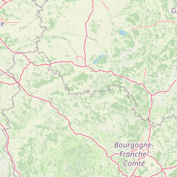
Map view of Réserve naturelle nationale du val de Loire

Use this park location map to pinpoint Réserve naturelle nationale du val de Loire in France, understand its exact geographic position, and read its mapped placement within the surrounding landscape more clearly.

Pigeon | © OpenStreetMap contributors

Location context for Réserve naturelle nationale du val de Loire

Bourgogne-Franche-ComtéCentre-Val de Loire

Visual exploration of floodplain forests, gravel bars, and river scenery

Réserve naturelle nationale du val de Loire Photos and Landscapes

Visual records capture the dynamic river channels, shifting sandbanks, and alluvial habitats that define the protected landscape. Examining park photography reveals the natural topography and wild terrain of the free-flowing Loire corridor.

Wide angle view of the Loire River with numerous exposed sandbars and shallow water channels, framed by green trees on the banks under a hazy sky.

A wide view of the Loire river with tall grasses in the foreground and a line of trees on the distant bank.

Park atlas

Compare adjacent river reserves and regional protected landscapes across the valley

Parks Near Réserve naturelle nationale du val de Loire and Surrounding Protected Areas

Continue exploring protected natural areas by comparing Réserve naturelle nationale du val de Loire with other notable river corridors and wildlife habitats. Examining adjacent regional geography reveals broader patterns in European floodplain conservation and wild river dynamics.
A horizontal watercolor painting showing a green landscape with a winding stream, patches of marshy water, and distant hills, with soft light and green trees on the sides.
Nature reserveBourgogne-Franche-Comté
About 25 km away#1 closest

East

Réserve naturelle régionale des Mardelles de Prémery: Protected Wetland and Forest Geography

Mapping the peatland depressions of the Prémery forest

This nature reserve protects a rare assemblage of mardelles, shallow forest pools set within the Prémery state forest. The landscape serves as a vital ecological archive, with peat deposits documenting environmental changes over 15 millennia. Explore the unique hydrological and botanical features of this protected lowland habitat nestled in the heart of the Nièvre department.

Area
2.525 km²
Established
2015
IUCN
IV
Watercolor painting of the Loire river showing trees along the banks and soft pink clouds in the background.
Nature reserveBourgogne-Franche-Comté
About 69 km away#2 closest

Southeast

Réserve naturelle régionale de la Loire bourguignonne: Regional Nature Reserve Map

Protected fluvial geography in Bourgogne-Franche-Comté

Located in the Nièvre department, this reserve protects an essential section of the Loire river. The landscape offers a rich mosaic of 31 natural habitats, featuring exposed gravel banks and riparian woodlands that support rare endemic flora and diverse ground-nesting bird populations.

Area
7.397 km²
Established
2015
IUCN
IV
Relief
Lowland
Nature reserveCentre-Val de Loire
About 78 km away#3 closest

West

Réserve naturelle régionale du Tertre des canaux: Protected Geography and Sologne Landscapes

A regional nature reserve protecting wetland mosaics in Loir-et-Cher

Situated in the heart of the Sologne, Réserve naturelle régionale du Tertre des canaux covers 35 hectares of diverse habitat. This reserve is defined by its characteristic interplay between small elevated landforms and historic water channels. It serves as an essential example of how targeted management protects ecologically rich terrain within the rural, inland geography of the Centre-Val de Loire region.

Area
0.351 km²
Established
2026
IUCN
IV
Relief
Lowland
A horizontal watercolor painting showing a small pond surrounded by soft green trees, grass, and a few small red flowers against a pale sky.
Nature reserveBourgogne-Franche-Comté
About 83 km away#4 closest

East

Réserve naturelle régionale des tourbières du Morvan: A Geographic Study of Peatland Protection

Regional Nature Reserve in the Bourgogne-Franche-Comté landscape

This expansive network reserve protects twelve notable peatlands across the departments of Nièvre and Saône-et-Loire. From the rare raised bog at Champgazon to the peat-fringed ponds of Étang Taureau, the reserve acts as a critical conservation mosaic that maintains the ecological connectivity of diverse sphagnum habitats within the greater Morvan regional landscape.

Area
2.66 km²
Established
2015
IUCN
IV
Relief
Mountain
Nature reserveAuvergne-Rhône-Alpes
About 83 km away#5 closest

Southeast

Réserve naturelle régionale du val de Loire Bourbonnais Protected Area and Atlas View

Riverine geography and floodplain landscapes in Allier, France

Examine the geographic profile of the Réserve naturelle régionale du val de Loire Bourbonnais. This site protects a significant stretch of the Loire River characterized by active meanders and alluvial deposits, representing a key example of riverine conservation in the Bourbonnais region of central France.

Area
3.08 km²
Established
2015
IUCN
IV
A soft, horizontal watercolor painting showing a meandering river winding through lush green riverbanks, with distant rolling hills against a white background.
Nature reserveAllier
About 84 km away#6 closest

South

Réserve naturelle nationale du val d'Allier Protected Area and River Corridor Map

Alluvial landscape and floodplain geography in central France

The Réserve naturelle nationale du val d'Allier encompasses a mosaic of gravel bars, islands, and side channels shaped by natural river dynamism. This protected expanse showcases a complete riparian forest sequence, providing a rare example of a largely untamed river floodplain preserved for its ongoing geomorphic activity.

Area
14.5 km²
Established
1994
IUCN
IV
Relief
Lowland
Nature reserveAuvergne-Rhône-Alpes
About 86 km away#7 closest

South

Espace naturel sensible de la Vauvre Protected Wetland Reserve and Geographic Landscape

Mapping wetland conservation in the Allier department

Covering 46 hectares of reclaimed terrain, this protected nature reserve provides a critical sanctuary for birds and wetland species. The site functions as a documented mosaic of ponds and damp grasslands, offering a clear example of localized ecological restoration within the broader context of the Cher valley geography.

Area
0.46 km²
Established
1996
IUCN
IV
Relief
Lowland
A horizontal watercolor illustration depicting a soft, light-toned marshy landscape with green trees, reeds, and rolling hills in the background.
Nature reserveÎle-de-France
About 120 km away#8 closest

North

Réserve naturelle régionale du marais de Larchant: Protected Landscape and Map Context

Wetland ecosystems at the edge of the Gâtinais plateau

Located in the Seine-et-Marne department, this regional nature reserve features a dynamic calcareous marsh ecosystem shaped by the Gâtinais plateau scarp. The site serves as a vital hydrological nexus, providing essential habitats for waterbirds and wetland flora through cyclic aquifer-fed flooding and diverse terrain patterns.

Area
1.24 km²
Established
2008
IUCN
IV
Relief
Lowland

Common questions about visiting, size, designation, and location context for Réserve naturelle nationale du val de Loire

Réserve naturelle nationale du val de Loire FAQs for park facts, access, geography, and protected area context

Find quick answers about Réserve naturelle nationale du val de Loire, including protected-area facts, park geography, trail and visitor context, and how the park fits into its surrounding country and regional landscape.
MoriAtlas Explorer

Continue Your Protected Areas Search Across the Global Atlas

Deepen your exploration by continuing the structured search for national parks and protected areas worldwide. Utilize the comprehensive filtering capabilities to compare different conservation landscapes and refine your understanding of global park geography. Discover more about the distribution and characteristics of protected natural areas.

Global natural geography