
Mori Atlas logo
Nature reserveRéserve naturelle régionale du plan d'eau de Reichshoffen

Mapping the natural geography, diverse habitat mosaic, and wetland corridors of this protected reserve

Réserve naturelle régionale du plan d'eau de Reichshoffen: A Protected Wetland Landscape in Grand Est

Réserve naturelle régionale du plan d'eau de Reichshoffen functions as a concentrated wetland sanctuary situated within the Vosges du Nord regional park in northeastern France. Spanning roughly 24 hectares, the area features a man-made water body surrounded by reedbeds, sedge communities, and alder woodland. This geography provides a crucial habitat mosaic for migratory birds and rare flora, showcasing how localized water management contributes to regional biodiversity within the Grand Est administrative territory.

wetlandsregional nature reservebirdwatchingreedbedssedge bedsalder woodland
A stylized flat vector illustration of a lake surrounded by rolling green hills, pine trees, and tall reeds in the foreground under a pale blue sky.

Réserve naturelle régionale du plan d'eau de Reichshoffen

Nature reserve

Park overview

Structured park overview, official facts, and landscape profile for Reichshoffen Regional Nature Reserve

Reichshoffen Regional Nature Reserve park facts, protected area profile, and essential visitor context

Review the core facts for Reichshoffen Regional Nature Reserve, including designation, size, terrain, visitor scale, habitats, and operating context in one park-focused overview.

About Reichshoffen Regional Nature Reserve

Reichshoffen Regional Nature Reserve is a compact protected area in the northern Alsace landscape, tucked into the foothills at the edge of the Vosges du Nord. Although it spans only about 24 hectares, it is regarded as an ecologically valuable site thanks to the convergence of wetland habitats, surrounding forest, and an artificial pond that has subsequently matured into a thriving wildlife habitat.

Geographically the reserve lies about two kilometers northeast of the market town of Reichshoffen, within the commune that gives the site its name. Administratively it falls under the Bas-Rhin department and the Grand Est region, and ecologically it is considered part of the larger Parc naturel régional des Vosges du Nord, a landscape of sandstone ridges, mixed forests, valleys, and modest elevations that straddles the Franco-German border.

The reserve's identity is shaped by the plan d'eau de Wolfartshoffen, an artificial lake that gives the protected area its focus. When it was originally created in 1982, the pond's purpose was primarily hydraulic: to regulate the flow of the Schwarzbach stream and reduce flood risk for the village. What began as an engineering measure evolved into an ecological asset, particularly once the surroundings were placed under voluntary protection in 1992 and later given stronger regional protection in 2014.

Today the reserve is appreciated both for its birdlife and for its mosaic of wet habitats. The plan d'eau itself is bordered by reedbeds, sedge beds, willow scrub, and alder woodland, while the local topography suggests a more pronounced relief than is typical of the open plains of Alsace, lending the area a slightly more sheltered microclimate. A walking path circles the water body, a botanical trail and picnic area are set up nearby, and a viewing platform provides an overlook for observing waterbirds.

Although small, the reserve illustrates a broader pattern in regional conservation in France: modest artificial water bodies, when paired with proactive habitat management, can become important refuges for biodiversity within larger regional parks, and can serve as accessible points of contact between residents, visitors, and the wider natural heritage of the Vosges du Nord.

Quick facts and research context for Reichshoffen Regional Nature Reserve

The Reichshoffen Regional Nature Reserve is a 24-hectare protected wetland in the Bas-Rhin department of Alsace, in northeastern France. It sits inside the Parc naturel régional des Vosges du Nord, at the locality of Wolfartshoffen, approximately 190 meters above sea level and roughly two kilometers from the town of Reichshoffen. Originally classified in 1992 as a voluntary nature reserve, it was upgraded to a regional nature reserve in November 2014, and is now jointly managed by SYCOPARC Vosges du Nord and the commune of Reichshoffen.

Protection and recognition

Documented terrestrial protection scope, designation year, and official recognition records

Protection Status and Designation History for Réserve naturelle régionale du plan d'eau de Reichshoffen

Terrestrial protection status for Réserve naturelle régionale du plan d'eau de Reichshoffen includes a formal designation year of 2014 within global protected area databases. Verified records compile documented conservation management frameworks and international recognition sources for structured geographical analysis.

Protection details

Protection scope
Terrestrial
Designated year
2014
Transboundary protection
No
WDPA ID
555597227
Park context

Deeper park guide and search-rich context for Reichshoffen Regional Nature Reserve

Reichshoffen Regional Nature Reserve history, landscape, wildlife, and travel context

Explore Reichshoffen Regional Nature Reserve through its history, landscape character, ecosystems, wildlife, conservation priorities, cultural context, and seasonal travel timing in a structured park guide built for atlas discovery and search intent.

Why Reichshoffen Regional Nature Reserve stands out

The reserve is known primarily as a compact wetland sanctuary within the Vosges du Nord regional park. Its centerpiece, the plan d'eau de Wolfartshoffen, attracts a remarkably diverse birdlife for such a small site, including breeding grebes, warblers, and buntings as well as wintering ducks and a range of migratory waterbirds. Beyond the avifauna, the reserve is appreciated for its layered wet habitats: open water framed by reedbeds, sedge communities, willow thickets, and alder woodland. Together these habitats create the moist, sheltered conditions that allow uncommon plants such as meadow campion, early purple orchid, incarnate orchid, and yellow flag iris to persist alongside more typical European wetland flora.
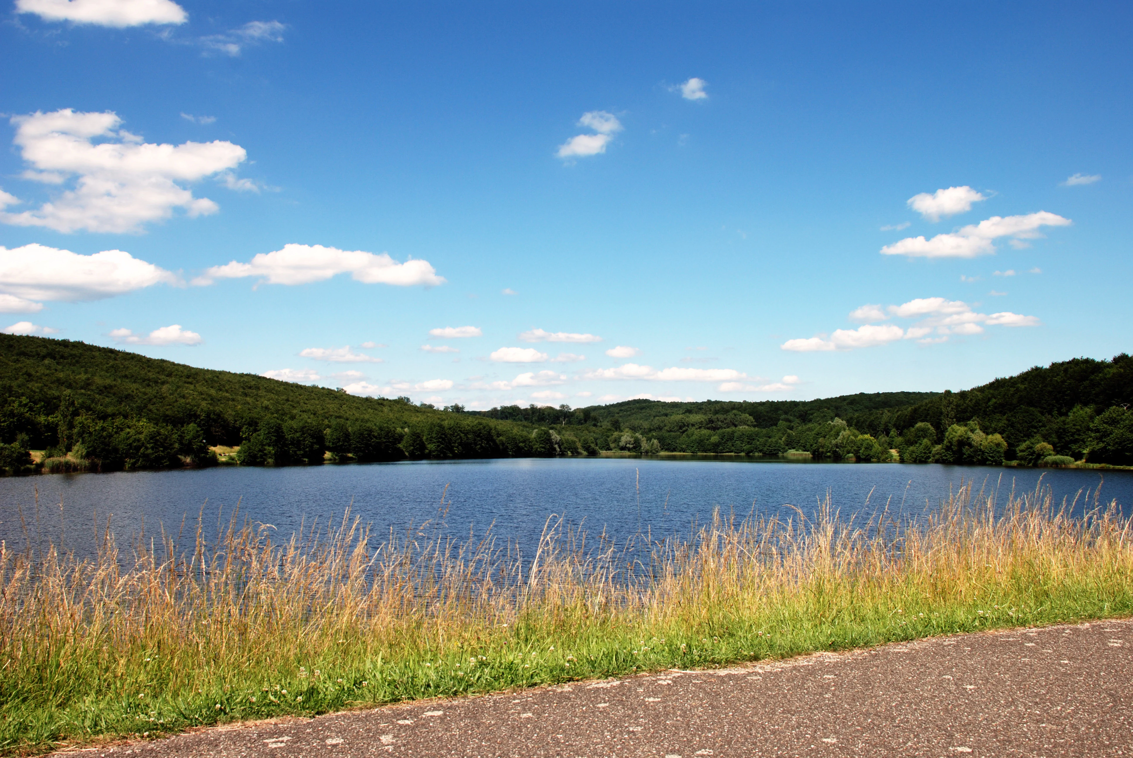
A wide shot of a calm blue reservoir surrounded by gentle, tree-covered hills under a bright blue sky with scattered white clouds, with tall grass in the foreground.
A view of the Wolfartshoffen reservoir within the Réserve naturelle régionale du plan d'eau de Reichshoffen.

Reichshoffen Regional Nature Reserve history and protected-area timeline

The reserve has its origins in a piece of local water management. In 1982, the plan d'eau de Wolfartshoffen was created as a flood-control reservoir to regulate the flow of the Schwarzbach stream and protect the village of Reichshoffen from flooding. The site was then developed for nearby tourism and outdoor recreation.

The ecological value of the new water body and its surroundings was formally recognized in 1992, when the site was classified as a réserve naturelle volontaire, or voluntary nature reserve, on 29 June 1992. This category of protection was a precursor to the more durable regional reserves later codified under French environmental law.

In November 2014, the site was reclassified as a full réserve naturelle régionale by decision of the Conseil régional, with the formal designation date of 14 November 2014. Since then, management of the reserve has been carried out jointly by SYCOPARC (the intermunicipal cooperation body of the Vosges du Nord regional park) and by the commune of Reichshoffen, which remains the central local authority for the protected area.

Reichshoffen Regional Nature Reserve landscape and geographic character

The reserve occupies a small but visually distinctive patch of countryside on the edge of the Vosges du Nord. Although the broader region of northern Alsace is often associated with flat farmland and the eastern plain, the area around Reichshoffen has stronger relief. Near the site, the topography is described as markedly hilly for the region, giving the reserve a feeling of enclosure that is sometimes likened to an "alpine" character, even though its elevation is only around 190 meters.

The defining physical feature is the plan d'eau de Wolfartshoffen itself, a roughly 24-hectare artificial lake whose winding shoreline is fringed by a continuous ring of wetland vegetation. Beyond the lakeside, the reserve is composed of wet and semi-wet habitats that occupy the gentle slopes and damp hollows around the water body. Slight variations in elevation, combined with the presence of groundwater and seasonal flooding, produce clear transitions between reedbeds, sedge beds, willow thickets, and alder woodland.

The reserve is set within the wider landscape of the Parc naturel régional des Vosges du Nord, which is characterized by sandstone uplands, pine and mixed forests, and agricultural valleys. Within that larger mosaic, the Reichshoffen reserve stands out as a concentrated wetland pocket, providing contrast to the surrounding forests and farmland.

Reichshoffen Regional Nature Reserve ecosystems, habitats, and plant life

Ecologically, the reserve is defined by its wetland mosaic, which includes four closely interlinked habitat types: cariçaies (sedge-dominated communities), phragmitaies (reedbeds), saulaies (willow thickets), and aulnaies (alder woodland). These habitats grade into one another around the plan d'eau, producing a layered environment where open water, emergent vegetation, and damp woodland are all within a short distance.

The vegetation reflects both the calcareous and silty wetland soils and the variation in water levels across the year. Damp meadows and wet woodland support a community that includes meadow campion, early purple orchid, incarnate orchid, and yellow flag iris, species that thrive in the moist conditions around the pond.

Because the reserve sits within the Parc naturel régional des Vosges du Nord, it also benefits from the broader ecological continuity of the regional park, where forest patches, streams, and farmland all play a role in maintaining habitat diversity. Within that larger landscape, the Reichshoffen reserve functions as a key stepping stone for wetland-associated species, especially birds and amphibians that depend on standing water for at least part of their life cycle.

Reichshoffen Regional Nature Reserve wildlife and species highlights

The wildlife profile of the reserve is dominated by its birds. Approximately 130 bird species have been recorded in or around the plan d'eau de Wolfartshoffen, of which about forty breed on site. Among the breeding species are great crested grebes, Eurasian reed warblers, and reed buntings, which use the reedbeds and fringes of the pond.

In winter, the water body attracts diving ducks such as common pochards and tufted ducks, along with northern pintails and little grebes, which take advantage of open water where they can dive and feed. During migration periods, the reserve becomes a temporary stopover for species that pass through the region, including common sandpipers, ospreys, common goldeneyes, and black-headed gulls, all of which use the lake and its edges as a resting and feeding point.

Mammals recorded in the reserve include the harvest mouse, the European polecat, and Daubenton's bat, species that use the wet edges, reedbeds, and nearby woodland. The amphibian fauna is also notable, with common toad, common frog, water frog, palmate newt, and the more localized yellow-bellied toad, the last typically associated with the small pools and shallow water margins that surround the main pond.

Among invertebrates, the copper butterfly of the marshes (Cuivré des marais) is noted as a characteristic species, reflecting the site's importance for wetland insects as well as for the larger animals that depend on them.

Reichshoffen Regional Nature Reserve conservation status and protection priorities

From a conservation perspective, the reserve is significant primarily as a compact refuge for wetland biodiversity within the larger framework of the Vosges du Nord regional park. Although small, the site brings together a suite of habitats that are increasingly scarce in agricultural parts of Alsace: open standing water, reedbeds, sedge communities, willow scrub, and alder woodland. These habitats support breeding, wintering, and migratory birds that depend on undisturbed water bodies, as well as amphibians, bats, and wetland insects.

The site's conservation history illustrates the layered French system of nature protection. It began in 1992 as a voluntary reserve, a lighter protective status driven by local initiative, and was upgraded in 2014 to a regional nature reserve, a stronger legal category that offers more durable protection and clearer management responsibilities. This reclassification reflected the growing recognition of the site's ecological value after more than two decades of protection.

Management today is shared between SYCOPARC, the cooperative body for the Vosges du Nord regional park, and the commune of Reichshoffen. Their joint stewardship focuses on maintaining the integrity of the wetland habitats, supporting breeding and migratory birdlife, and keeping the reserve accessible to residents and visitors through marked trails, a botanical path, and a viewing point. In this way, the reserve functions as both a conservation site and a local point of contact between people and the natural heritage of the Vosges du Nord.

Reichshoffen Regional Nature Reserve cultural meaning and human context

Culturally, the reserve is rooted in the local identity of Reichshoffen, a small town in northern Alsace with a long history tied to the foothills of the Vosges. The site's creation in 1982 was originally a pragmatic act of landscape engineering: a flood-control reservoir designed to protect the village. Over time, the same infrastructure came to be appreciated for its recreational and ecological value, and the surrounding area was deliberately set aside as a nature reserve.

The reserve also sits within the broader regional identity of Alsace, where informal sandstones, forested slopes, and small valleys have shaped traditional patterns of land use and outdoor life. Embedded inside the Parc naturel régional des Vosges du Nord, the protected area contributes to the regional narrative of preserving both natural and cultural landscapes in a region that has long been a meeting point between French and Germanic cultural influences.

Top sights and standout views in Reichshoffen Regional Nature Reserve

The reserve's highlight is the way a modest, man-made pond has matured into a rich wetland refuge, supporting around 130 bird species, a layered mosaic of wet habitats, and a small but interesting community of wetland plants. Surrounded by strong local relief and set inside the Vosges du Nord regional park, the site provides an unusually compact example of wetland conservation in action.

Equally notable is the reserve's accessibility. A marked path circles the lake, a botanical trail and a picnic area are nearby, and a viewing platform offers an overlook for observing waterbirds. These features make the reserve not only a conservation site but also a practical entry point for visitors interested in the natural heritage of northern Alsace.

Best time to visit Reichshoffen Regional Nature Reserve

The reserve has a different character in each season. Spring and early summer are the most rewarding times for birdwatchers and naturalists, as the reedbeds come alive with breeding waterbirds and the botanic trail is at its most interesting. Migratory species also bring added diversity to the site during the spring and autumn passage seasons.

In winter, the open water of the plan d'eau attracts diving ducks, pochards, and goldeneyes, turning the lake into a quieter but still active wildlife scene. Summer visits offer pleasant walking conditions and the full development of wetland vegetation, though visitors should expect the lake environment to feel more enclosed by reeds and foliage. Across the year, the wetter conditions of the site mean that sturdy footwear is appropriate for the trails around the pond in any season.


Monthly climate preview

Long-term representative measurements of temperature and precipitation rhythms across the protected landscape

Réserve naturelle régionale du plan d'eau de Reichshoffen Climate Normals and Monthly Weather Patterns

Representative coordinates record measured temperature variation alongside stable daily precipitation rates throughout the annual cycle at Réserve naturelle régionale du plan d'eau de Reichshoffen. Detailed monthly climate records expand the scope with complete multi-year averages for comprehensive environmental analysis.
Annual mean10 °C
0 °C20 °C
Jan
Feb
Mar
Apr
May14°
Jun17°
Jul20°
Aug19°
Sep15°
Oct10°
Nov
Dec
Warmest month
July

19.6 °C

Coolest month
January

0.4 °C

Wettest month
December

2.4 mm/day

Driest month
April

1.5 mm/day

Park location guide

Geography guide, regional context, and park location map for Reichshoffen Regional Nature Reserve

Reichshoffen Regional Nature Reserve park geography, regions, and map view in France

Understand where Reichshoffen Regional Nature Reserve sits in France through a broader geographic reading of the surrounding landscape, nearby location context, and its mapped position within the national park landscape.

How Reichshoffen Regional Nature Reserve fits into France

France is a unitary semi-presidential republic and one of the world's largest economies. It borders Belgium, Luxembourg, Germany, Switzerland, Italy, Monaco, Andorra, and Spain, with a maritime border to the United Kingdom. The country is known for its cultural influence, art, cuisine, and political history spanning centuries.

Wider geography shaping Reichshoffen Regional Nature Reserve in France

France is located in Western Europe. Metropolitan France extends from the Rhine to the Atlantic Ocean and from the Mediterranean Sea to the English Channel and North Sea. The country borders Belgium, Luxembourg, Germany, Switzerland, Italy, Monaco, Andorra, Spain, and has a maritime border with the United Kingdom.

Map view of Reichshoffen Regional Nature Reserve

Use this park location map to pinpoint Reichshoffen Regional Nature Reserve in France, understand its exact geographic position, and read its mapped placement within the surrounding landscape more clearly.

Pigeon | © OpenStreetMap contributors

Location context for Reichshoffen Regional Nature Reserve

Grand Est

Visualizing the wetland habitats, water bodies, and terrain of the Vosges du Nord sanctuary.

Réserve naturelle régionale du plan d'eau de Reichshoffen Photos and Protected Landscape Scenery

Photographic collections reveal the intricate mosaic of reedbeds, open water, and alder woodland defining the protected area. Visual documentation provides essential geographic context for examining the specialized wetland habitats and regional terrain surrounding the reserve.

A wide shot of a calm blue reservoir surrounded by gentle, tree-covered hills under a bright blue sky with scattered white clouds, with tall grass in the foreground.

Several geese and a dark, low-slung coypu resting on a grassy lakeshore with trees and water in the background.

Park atlas

Compare nearby protected areas and regional wetland landscapes across northern Alsace

Other Parks Near Réserve naturelle régionale du plan d'eau de Reichshoffen

Browsing nearby protected areas allows visitors to compare similar wetland sanctuaries and forested reserves located throughout the surrounding region. Extending the geographic review beyond Réserve naturelle régionale du plan d'eau de Reichshoffen reveals broader patterns in regional conservation.
Nature reserveRheinland-Pfalz
About 14 km away#1 closest

North

Rohrweiher-Rösselsweiher Nature Reserve: Geography and Protected Area Mapping

Wetland and bog landscapes in the Rheinland-Pfalz region

Rohrweiher-Rösselsweiher is a distinctive nature reserve covering 40 hectares of complex wetland, bog, and forest edge habitats. Defined by the convergence of two forest streams, the area functions as a critical component of the regional ecology within the Palatinate Forest. This entry provides mapped insights into the hydrological features and protected land boundaries that define this vital German nature preserve.

Area
0.405 km²
Established
1979
Scope
Terrestrial
Water
Major water bodies
A pale, soft watercolor illustration depicting a calm lake landscape with green hills, trees, and marshy shoreline on a white background.
Nature reserveRheinland-Pfalz
About 14 km away#2 closest

North

Pfälzerwoog Nature Reserve: A Detailed Atlas Overview of Protected Wetland Landscapes in Rhineland-Palatinate

Ecological wetlands within the Palatinate Forest sandstone terrain.

Pfälzerwoog is a protected nature reserve encompassing shallow-water, shoreline, and bog habitats within the Wasgau region of Rhineland-Palatinate. As a distinct hydrological feature in a forest-dominated landscape, the reserve provides a critical look at how rare moist-habitat mosaics survive in the sandy, forested topography near the Franco-German border.

Area
0.113 km²
Established
1979
Relief
Lowland
Climate
Temperate
Nature reserveRheinland-Pfalz
About 15 km away#3 closest

North

Königsbruch Nature Reserve: Geographic Map and Protected Landscape Overview

Riparian ecosystems and stream networks in Rheinland-Pfalz

Königsbruch represents a vital conservation landscape in the southern Palatinate Forest, characterized by its damp woodland and the convergence of the Saarbach stream system. Our detailed geographic mapping reveals the protected valley corridors of this nature reserve, providing a clear view of its terrain, hydrological features, and boundary context within the region of Rheinland-Pfalz.

Area
1.226 km²
Established
1996
Nature reserveRheinland-Pfalz
About 15 km away#4 closest

Northeast

Zeppelinhalde Nature Reserve: A Protected Juniper Hillside in the Southern Palatinate Landscape

Mapped protected habitats in the Rheinland-Pfalz region

Zeppelinhalde is a protected nature reserve in the Südwestpfalz, characterized by its rare juniper-dominated dry grassland habitat on the eastern slopes of the Kuhnenkopf. This area serves as a vital ecological link within the cross-border Palatinate Forest landscape, contrasting open, sun-exposed terrain with surrounding woodland ridges near the French border.

Established
1942
Nature reserveRhineland-Palatinate
About 16 km away#5 closest

Northeast

Brauntal Nature Reserve: Protected Wetland Landscapes and Geography in Southern Palatinate

Mapped protected areas in Rhineland-Palatinate, Germany

Brauntal serves as an important nature reserve centered on a dystrophic pond and its surrounding silting zones. The site acts as a critical protected habitat within the Südwestpfalz region, offering insights into wetland ecology, stream headwaters, and hilly transition zones near the French border.

Area
0.71 km²
Established
1984
Nature reserveRheinland-Pfalz
About 16 km away#6 closest

North

Faunertal Nature Reserve and Palatinate Forest Wetland Mapping

A protected aquatic mosaic in southwestern Germany

Faunertal represents a specialized nature reserve in Rheinland-Palatinate characterized by its chain of abandoned fish ponds along the Dielbach. The site provides a clear case study in landscape transformation, where historic ponds now support diverse sedge mires, reed beds, and complex wetland ecosystems. This area serves as a critical focus for amphibian conservation and habitat connectivity within the broader forest geography of the Palatinate region.

Area
0.253 km²
Established
1983
Nature reserveRheinland-Pfalz
About 17 km away#7 closest

North

Wolfsägertal Nature Reserve: Mapped Wetlands and Sandstone Valley Geography

Protected aquatic ecosystems in the Wasgau, Rheinland-Pfalz

Discover the precise geographic footprint and ecological characteristics of Wolfsägertal. This nature reserve, located within the forested sandstone terrain of the Wasgau, provides a concentrated study of stream-side wetland habitats, including the Nollenkopf impoundment and associated fen meadows, all mapped and structured for clear regional context.

Area
0.222 km²
Established
1983
Nature reserveRheinland-Pfalz
About 19 km away#8 closest

Northwest

Quellbäche des Eppenbrunner Baches: Mapping Protected Wetlands and Spring-Fed Valleys

An essential nature reserve landscape in southwestern Germany

Located in the Südwestpfalz district, Quellbäche des Eppenbrunner Baches guards the vital headwaters and stream-valley systems feeding the Eppenbrunner Bach. This protected area stands out for its compressed transition between groundwater-fed wetlands, small impoundment ponds, and drier rocky forest slopes that span toward the French border.

Area
0.94 km²
Established
1991

Common questions about visiting, size, designation, and location context for Reichshoffen Regional Nature Reserve

Reichshoffen Regional Nature Reserve FAQs for park facts, access, geography, and protected area context

Find quick answers about Reichshoffen Regional Nature Reserve, including protected-area facts, park geography, trail and visitor context, and how the park fits into its surrounding country and regional landscape.
MoriAtlas Explorer

Continue Your Protected Areas Search Across the Global Atlas

Deepen your exploration by continuing the structured search for national parks and protected areas worldwide. Utilize the comprehensive filtering capabilities to compare different conservation landscapes and refine your understanding of global park geography. Discover more about the distribution and characteristics of protected natural areas.

Global natural geography