Mori Atlas logo
Nature reserveRéserve naturelle régionale Im'Berg

Examine the geography and rare boxwood habitats of this unique protected slope.

Réserve naturelle régionale Im'Berg: A Protected Calcareous Grassland Landscape in Grand Est

(Réserve naturelle régionale Im'Berg (RNR268))

Réserve naturelle régionale Im'Berg, located in the Grand Est region of northeastern France, represents a vital protected sanctuary for rare calcareous dry grassland. This steep, south-facing hillside in the Haut-Rhin department serves as a distinctive ecological anchor, preserving relict boxwood stands and orchid populations on limestone substrates. The site provides a focused study in xeric habitat conservation, where specific microclimates enable warm-loving plant communities to flourish at the northern edge of their European range.

regional nature reservecalcareous dry grasslanddry grasslandboxwood habitatAlsaceGrand Est

Réserve naturelle régionale Im'Berg

Nature reserve

Park overview

Structured park overview, official facts, and landscape profile for Réserve naturelle régionale Im'Berg

Réserve naturelle régionale Im'Berg park facts, protected area profile, and essential visitor context

Review the core facts for Réserve naturelle régionale Im'Berg, including designation, size, terrain, visitor scale, habitats, and operating context in one park-focused overview.

About Réserve naturelle régionale Im'Berg

Réserve naturelle régionale Im'Berg is a very small but ecologically focused regional nature reserve in Alsace, in the Grand Est region of northeastern France. Occupying roughly 1.7 hectares on a hillside above the village of Tagolsheim in the Haut-Rhin department, the reserve centers on a patch of calcareous dry grassland, locally referred to as the Buxberg, that has survived amid centuries of agricultural transformation of the surrounding plain and foothill landscape.

The protected area is registered as RNR268 and falls under the category IV designation of the International Union for Conservation of Nature for habitat and species management areas. Although small in extent, the reserve draws interest because it protects a particularly well-preserved example of a habitat type that has become rare in the region: open, sun-exposed, lime-rich grassland threaded with shrubs and isolated trees, supporting specialist plants adapted to dry, warm conditions.

Geographically, the reserve sits in what is broadly the Alsatian foothill belt, south of the main Vosges range, where Jurassic and related limestone substrates create conditions favorable for thermophilic plant communities. The hillside setting, combined with the calcareous substrate, generates the microclimate and soil chemistry that allow Mediterranean and sub-Mediterranean species to persist far north of their main distribution. Im'Berg exemplifies how a small, carefully selected site can preserve a meaningful slice of this regional botanical heritage.

Beyond its ecological role, the reserve provides a reference point for the broader network of regional nature reserves in France, illustrating how very small reserves can concentrate conservation value on single habitats of regional significance. It is also a local landmark for the commune of Tagolsheim, framing the village's western edge with a distinctive semi-natural green slope.

Quick facts and research context for Réserve naturelle régionale Im'Berg

Réserve naturelle régionale Im'Berg is a regional nature reserve (réserve naturelle régionale) in the Grand Est region of France, administratively located in the Haut-Rhin department on the commune of Tagolsheim. It was officially created on 8 February 2013 by délibération of the Regional Council, replacing an earlier 1988 voluntary nature reserve designation known as Tagolsheim Semberg.

The reserve covers approximately 1.7 hectares of calcareous dry grassland on a south-facing slope. Its conservation purpose centers on preserving a relict thermophilic plant community, including the northernmost known natural boxwood population in Europe and a notable presence of wild orchids.

Protection and recognition

Documented protected area boundaries and international database metadata

Réserve naturelle régionale Im'Berg Protection Status and Designation Records

Protected area designation records for Réserve naturelle régionale Im'Berg assemble official registry entries and database identifiers into a unified view. Administrative records provide verifiable baseline metrics for conservation geography and territorial boundaries.

Protection details

WDPA ID
555561887
Park context

Deeper park guide and search-rich context for Réserve naturelle régionale Im'Berg

Réserve naturelle régionale Im'Berg history, landscape, wildlife, and travel context

Explore Réserve naturelle régionale Im'Berg through its history, landscape character, ecosystems, wildlife, conservation priorities, cultural context, and seasonal travel timing in a structured park guide built for atlas discovery and search intent.

Why Réserve naturelle régionale Im'Berg stands out

Im'Berg is primarily known for protecting one of the northernmost populations of common boxwood (Buxus sempervirens) in Europe, growing on a calcareous dry slope known as the Buxberg. The reserve also conserves a species-rich fragment of calcareous dry grassland, a habitat type that has strongly declined across the Alsatian landscape. The combination of an unusually northerly relict boxwood stand, the orchid population on the same hillside, and the broader dry-grassland community makes this tiny reserve a distinctive reference site for understanding warm-loving plant communities at the northern edge of their European range.
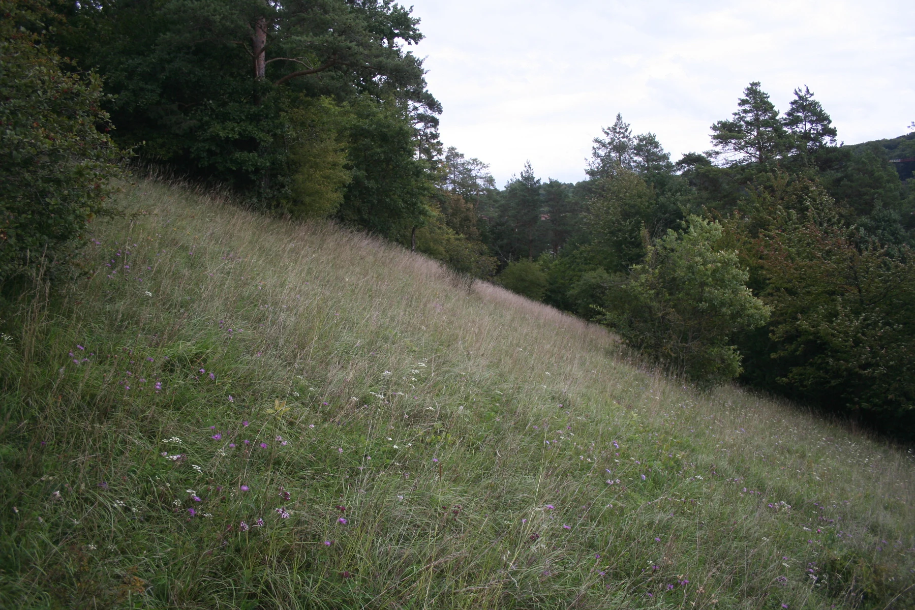
A grassy hillside covered in tall wild grasses and scattered purple wildflowers, with dense trees lining the upper left and right edges and a cloudy sky above.
Calcareous grassland slope at Réserve naturelle régionale Im'Berg, bordered by mixed forest under an overcast sky.

Réserve naturelle régionale Im'Berg history and protected-area timeline

The site that is now the Réserve naturelle régionale Im'Berg was first given formal natural-area protection in 1988, when it was classified as a réserve naturelle volontaire under the name Tagolsheim Semberg, with the reference number RNR47. This initial designation recognized the hillside as a worthy conservation site, but it operated under the lighter framework of voluntary reserves, which depended on landowner agreement rather than full regional deliberation.

Following the reform of France's regional nature reserve framework, the site was placed under préfectoral protection from 2012, providing temporary administrative backing for the transition. The reserve then received its current status as a full réserve naturelle régionale by a délibération of the Conseil régional on 8 February 2013, giving it the new reference number RNR268 and consolidating its protection under the regional authority.

The shift from voluntary reserve to regional nature reserve marked a significant strengthening of the site's legal protection and brought it into the national network managed alongside the other regional nature reserves of France. This evolution reflects the broader pattern in which small but ecologically distinctive sites were progressively upgraded as the regional reserve system matured in the early 2010s.

Réserve naturelle régionale Im'Berg landscape and geographic character

The landscape of Im'Berg is defined by a steep, south-facing hillside rising above the village of Tagolsheim, in the Alsatian foothill zone between the Rhine plain and the Vosges mountains. The slope is underlain by calcareous substrates, and its orientation allows strong solar exposure, generating the warm, dry microclimate that distinguishes this site from the surrounding agricultural lowlands.

Vegetatively, the hillside is dominated by open calcareous dry grassland, an unusual sight in a region more typically associated with vineyards, cereal fields, and broadleaf forest on the higher slopes. The open herb-rich grassland is broken by scattered shrubs and small patches of scrub, with small rocky outcrops where the underlying limestone approaches the surface. From a distance, the Buxberg reads as a strip of light, sun-bleached vegetation running along the hillside, contrasting visually with the greener fields and woodlands around it.

The microtopography of the slope, combined with the thin, stony soils, helps create the xeric conditions that support the reserve's characteristic flora. Sun-baked rock surfaces, dry turf, and sheltered crevices produce a mosaic of microhabitats within a very small area, illustrating how topography can concentrate ecological value on a single hillside.

Réserve naturelle régionale Im'Berg ecosystems, habitats, and plant life

Ecologically, Im'Berg is best understood as a fragment of calcareous dry grassland, a habitat that depends on a combination of lime-rich soils, steep slopes, and a long history of low-intensity use that prevented forest closure. Such dry grasslands have become strongly reduced in Alsace and across much of western Europe, surviving mainly on slopes too steep or rocky for cultivation.

The grassland community is botanically rich relative to its size, hosting a mixture of grasses and forbs adapted to dry conditions, together with a notable population of wild orchids. The exposed limestone and thin soils favor specialist plants able to cope with summer drought, while the open structure of the vegetation allows light-demanding species to thrive.

The most exceptional ecological feature of the site is its boxwood population, growing on the slope known as the Buxberg. This is considered the northernmost natural station of Buxus sempervirens in Europe, a relict occurrence at the climatic edge of the species' natural range. The boxwood shrubs add a distinctive evergreen, sclerophyllous element to what would otherwise be a thoroughly dry-grassland vegetation pattern.

Réserve naturelle régionale Im'Berg wildlife and species highlights

The reserve's ecological value is primarily botanical rather than faunal, and the available documentation on its animal life is limited. The dry, open structure of the calcareous grassland and the presence of flowering plants, including orchids, provide habitat for the typical invertebrate assemblages associated with this habitat type in the region.

Such xeric slopes in Alsace generally support a range of insects, including butterflies, bees, and other pollinators adapted to dry grassland, as well as the small vertebrates and ground fauna that use the moss and litter layer beneath the shrubs. The scattered shrubs and rocky crevices also offer shelter and basking sites for reptiles typical of warm open habitats in the area.

Because the wildlife information in the source material is sparse, specific species associated with the reserve cannot be confidently listed. The reserve should be understood primarily as a plant-focused conservation site, with animal communities present in patterns consistent with similar dry-grassland slopes elsewhere in the region.

Réserve naturelle régionale Im'Berg conservation status and protection priorities

Im'Berg's conservation significance lies in the protection of a relict calcareous dry grassland on a lime-rich Alsatian slope, a habitat type heavily reduced by agricultural intensification, afforestation, and abandonment across the region. By safeguarding even 1.7 hectares of this vegetation, the reserve preserves a representative sample of a community that has largely disappeared from the surrounding lowlands and gentler slopes.

The reserve's most distinctive conservation value is its boxwood population, the northernmost natural station of common boxwood known in Europe. This makes the site important not only regionally but also in a broader European biogeographical context, as a living record of how far north Mediterranean shrub species can persist under favorable microclimatic conditions.

The site is classified as a regional nature reserve under French law and recognized internationally under IUCN category IV, habitat and species management area. Its legal protection was originally established as a voluntary reserve in 1988 and was strengthened in 2013 when the Regional Council of Alsace formally created the current réserve naturelle régionale, providing a durable framework for habitat management and continued monitoring of this small but ecologically significant slope.

Réserve naturelle régionale Im'Berg cultural meaning and human context

Im'berg occupies a culturally meaningful place in its immediate locality. The hillside, called the Buxberg, names the reserve and reflects the historical recognition of its distinctive vegetation by surrounding communities, particularly through the presence of boxwood, an uncommon shrub in the local landscape.

The reserve sits at the edge of the village of Tagolsheim, a commune in the Haut-Rhin department with a long agricultural tradition rooted in the Alsatian plain. The protected slope effectively preserves a semi-natural element of the historical rural landscape, set aside as land use intensified around it. This gives the reserve a local heritage dimension alongside its strict ecological role, illustrating how small pieces of the old cultural landscape can be conserved as part of regional identity in Alsace.

At a wider level, the reserve belongs to the network of regional nature reserves that have become an important part of how French regions express their natural heritage and ecological priorities, contributing to a broader sense of Alsatian environmental identity that extends beyond the better-known vineyards and mountain forests.

Top sights and standout views in Réserve naturelle régionale Im'Berg

A key highlight of Im'Berg is the Buxberg itself, the calcareous dry slope that hosts the northernmost natural population of common boxwood in Europe. This unusual biogeographical feature alone makes the reserve noteworthy among Europe's small protected sites.

Equally important is the reserve's compact concentration of calcareous dry grassland habitat, supporting a community of orchids and other specialist dry-habitat plants on a sunny hillside. The combination of relict shrub vegetation and species-rich dry grassland within just 1.7 hectares gives Im'Berg an ecological density that contrasts sharply with its small footprint.

The site's evolution from a 1988 voluntary reserve to a fully-fledged regional nature reserve in 2013 also marks it as a small but instructive example of how France's regional reserve system has matured, providing a legally robust anchor for ongoing habitat management on this distinctive Alsatian slope.

Best time to visit Réserve naturelle régionale Im'Berg

Im'Berg is a small, openly vegetated hillside that can be appreciated across much of the year, but late spring and early summer are typically the most rewarding periods for visiting a calcareous dry grassland of this type. Warmer months bring the orchids and other wildflowers into bloom and highlight the contrast between the dry, light-colored slope and the greener surrounding countryside.

In late summer, the dry character of the habitat becomes most apparent, with grasses turning golden and the Mediterranean character of the boxwood community standing out against the landscape. Cooler months still allow appreciation of the slope's structure and views over the Alsatian plain, though the botanical interest is reduced outside the growing season. Visitors should treat the reserve as a small, protected natural site rather than a developed visitor attraction, focusing on low-impact enjoyment of the habitat and its views.

Monthly climate preview

Long-term representative point measurements tracking monthly temperature and precipitation cycles

Réserve naturelle régionale Im'Berg Climate Normals and Annual Temperature Rhythm

Representative coordinate records show average temperatures ranging from negative values in winter months to warm summer peaks, accompanied by steady year-round precipitation. Exploring the complete twelve-month climatology dataset reveals detailed monthly shifts in long-term temperature normals and rainfall patterns.
Annual mean9 °C
-1 °C18 °C
Jan-1°
Feb
Mar
Apr
May13°
Jun16°
Jul18°
Aug18°
Sep14°
Oct
Nov
Dec
Warmest month
July

18.2 °C

Coolest month
January

-0.6 °C

Wettest month
May

3.7 mm/day

Driest month
February

2.2 mm/day

Park location guide

Geography guide, regional context, and park location map for Réserve naturelle régionale Im'Berg

Réserve naturelle régionale Im'Berg park geography, regions, and map view in France

Understand where Réserve naturelle régionale Im'Berg sits in France through a broader geographic reading of the surrounding landscape, nearby location context, and its mapped position within the national park landscape.

How Réserve naturelle régionale Im'Berg fits into France

France is a unitary semi-presidential republic and one of the world's largest economies. It borders Belgium, Luxembourg, Germany, Switzerland, Italy, Monaco, Andorra, and Spain, with a maritime border to the United Kingdom. The country is known for its cultural influence, art, cuisine, and political history spanning centuries.

Wider geography shaping Réserve naturelle régionale Im'Berg in France

France is located in Western Europe. Metropolitan France extends from the Rhine to the Atlantic Ocean and from the Mediterranean Sea to the English Channel and North Sea. The country borders Belgium, Luxembourg, Germany, Switzerland, Italy, Monaco, Andorra, Spain, and has a maritime border with the United Kingdom.

Map view of Réserve naturelle régionale Im'Berg

Use this park location map to pinpoint Réserve naturelle régionale Im'Berg in France, understand its exact geographic position, and read its mapped placement within the surrounding landscape more clearly.

Pigeon | © OpenStreetMap contributors

Location context for Réserve naturelle régionale Im'Berg

Grand Est

Visual reference of calcareous slopes, boxwood habitats, and regional terrain

Réserve naturelle régionale Im'Berg Photos, Scenery, and Landscapes

Visual documentation captures the steep calcareous slopes, rare boxwood stands, and sun-baked dry grasslands defining the protected hillside. Detailed photographic records reveal the distinct microtopography and specialized plant communities sustaining this regional reserve.

A grassy hillside covered in tall wild grasses and scattered purple wildflowers, with dense trees lining the upper left and right edges and a cloudy sky above.

Park atlas

Compare regional limestone slopes and nearby protected natural reserves

Other Parks and Protected Areas Near Réserve naturelle régionale Im'Berg

Browsing nearby protected areas allows researchers to compare lime-rich slope habitats and specialized dry grassland ecosystems across the surrounding region. Extending the geographic review helps place local relict flora within the wider conservation landscape of northeastern France.
A panoramic watercolor painting depicting a calm wetland or marsh with pink and yellow reeds in the foreground, green trees in the midground, and soft purple mountains in the background.
Nature reserveHaut-Rhin
About 14 km away#1 closest

North

Réserve naturelle régionale des marais et landes du Rothmoos Protected Landscape and Geography

Regional nature reserve in the Haut-Rhin department of Alsace

The Réserve naturelle régionale des marais et landes du Rothmoos encompasses a rare inland saline habitat complex within the Nonnenbruch forest. Its terrain is defined by stable pools created from mining subsidence, transitioning into heathland and oak forests. This protected area stands as an ecological refuge for migratory waterbirds and specialized aquatic species within an industrial-legacy environment.

Area
1.457 km²
Established
1988
IUCN
IV
Relief
Lowland
A horizontal watercolor illustration showing a winding river through a flat, green landscape with distant hills under a soft pink and yellow sky.
Nature reserveHaut-Rhin
About 20 km away#2 closest

East

Réserve naturelle nationale de la Petite Camargue alsacienne: Protected Rhine Floodplain Geography

A unique wetland and alluvial forest habitat in Haut-Rhin

Investigate the geographic significance of the Réserve naturelle nationale de la Petite Camargue alsacienne. This site acts as a protected reference for Upper Rhine floodplain ecology, showcasing a rare intersection of relict river meanders, marshy depressions, and diverse vegetation types near the French, Swiss, and German borders.

Area
9.04 km²
Established
1982
IUCN
IV
Relief
Lowland
Nature reserveGrand Est
About 26 km away#3 closest

North

Réserve naturelle régionale de l'Eiblen et l'Illfeld: Alsace Floodplain Protected Area

Geographic context of regional alluvial habitats in Haut-Rhin

Located in the Alsace plain, this nature reserve preserves a rare cross-section of original river floodplain geography. The area provides a critical look at alluvial ecosystems and sediment-rich lowland terrain that defines the historical character of the Upper Rhine plain within France.

Area
0.66 km²
Established
1992
A soft watercolor painting of a rolling landscape with green hills, light blue distant mountains, and patches of pink and yellow vegetation.
Nature reserveGrand Est
About 29 km away#4 closest

Northwest

Réserve naturelle régionale de la forêt des volcans de Wegscheid: Geological Protected Area

Mapping volcanic terrain in the Grand Est region of eastern France.

Located in the Haut-Rhin, this regional nature reserve preserves a distinct volcanic landscape characterized by rocky promontories, basalt columns, and mature forest stands. The protected terrain features varied elevation from 700 meters to the Rossberg ridge, showcasing geological formations that have remained largely untouched by intensive historical forestry.

Area
1.015 km²
Established
2008
IUCN
IV
Relief
Mountain
Nature reserveGrand Est
About 32 km away#5 closest

North

Réserve naturelle régionale des collines de Rouffach: Protected Hills and Dry Grasslands

A Mediterranean-influenced nature reserve in the Alsace foothills.

Located in the Grand Est region, this reserve preserves Bollenberg and Strangenberg hills through a mosaic of downy oak woodland and xerobrometum grasslands. The site functions as a botanical refuge where limestone geology creates an exceptionally warm, arid environment rare for northeastern France.

Area
0.44 km²
Established
2013
IUCN
IV
A wide watercolor painting depicting a calm river or lake flanked by green and purple vegetation, with distant mountains under a soft pink and yellow sky.
Nature reserveDoubs
About 35 km away#6 closest

Southwest

Réserve naturelle régionale de la basse vallée de la Savoureuse: Regional Nature Reserve

Protected alluvial floodplain geography in Doubs, France.

This nature reserve safeguards a significant fragment of the Savoureuse river floodplain. The protected area offers a complete alluvial sequence within 42 hectares, including active gravel bars and mature ash-alder woodlands, providing a high-density ecological core amidst an industrial landscape in the Doubs department.

Area
0.419 km²
Established
2008
IUCN
IV
Relief
Lowland
Nature reserveGrand Est
About 38 km away#7 closest

Northeast

Réserve naturelle régionale de la forêt de Mequillet Le Hardtwald Geographic Atlas and Map

Protected dry forest and steppe habitat in Grand Est

Situated on the elevated terraces of the Rhine floodplain, this nature reserve protects 249 hectares of distinct dry woodland and open clearings. The landscape offers a rare example of continental flora and saproxylic beetle habitats, set within the broader agricultural context of the Alsace plain. This record provides a comprehensive view of the park boundaries and ecological geography found within this significant French conservation area.

Area
2.49 km²
Established
2012
IUCN
IV
Relief
Lowland
A horizontal watercolor painting depicting a landscape with soft rolling hills, green meadows, and wild grasses under a pale sky.
Nature reserveBaden-Württemberg
About 40 km away#8 closest

East

Dinkelberg und Röttler Wald: Geographic Overview of this Baden-Württemberg Nature Reserve

Protected karst landscapes and mature beech forest habitat

Uncover the ecological and physical geography of Dinkelberg und Röttler Wald, a protected area stretching across diverse limestone plateaus and sandstone slopes in Germany. This site offers a valuable look at managed cultural landscapes that bridge the gap between rural meadows and wild forest reserves, providing critical habitat for European bat populations and rare flora across its varied elevational zones.

Area
46.47 km²
Established
2015

Common questions about visiting, size, designation, and location context for Réserve naturelle régionale Im'Berg

Réserve naturelle régionale Im'Berg FAQs for park facts, access, geography, and protected area context

Find quick answers about Réserve naturelle régionale Im'Berg, including protected-area facts, park geography, trail and visitor context, and how the park fits into its surrounding country and regional landscape.
MoriAtlas Explorer

Continue Your Protected Areas Search Across the Global Atlas

Deepen your exploration by continuing the structured search for national parks and protected areas worldwide. Utilize the comprehensive filtering capabilities to compare different conservation landscapes and refine your understanding of global park geography. Discover more about the distribution and characteristics of protected natural areas.

Global natural geography