
Mori Atlas logo
Nature reserveRezerwat przyrody Mingos

Examining the ecological boundaries and regional geography of a preserved Mazovian woodland.

Rezerwat przyrody Mingos: Protected Dry Pine Forest Landscapes of the Kurpie Plain in Poland

Rezerwat przyrody Mingos represents a compact, ecologically significant nature reserve located in the Mazowieckie Voivodeship of northeastern Poland. This 13.46 hectare site preserves a representative fragment of the historical Kurpie Pine Forest, specifically the dry blueberry pine forest community known as bór brusznicowy. Situated within the Równina Kurpiowska lowland mesoregion, the reserve serves as a critical benchmark for studying forest dynamics, sandy-soil ecology, and post-disturbance terrain character across the broader Kurpie landscape.

forest reservepine forestKurpie Plainbór brusznicowyScots pineMazovia
A flat-style digital illustration of a mountain valley with a winding river, a waterfall in the distance, and tall pine trees in the foreground, featuring a fallen log in the immediate foreground.

Rezerwat przyrody Mingos

Nature reserve

Park overview

Structured park overview, official facts, and landscape profile for Mingos Nature Reserve

Mingos Nature Reserve park facts, protected area profile, and essential visitor context

Review the core facts for Mingos Nature Reserve, including designation, size, terrain, visitor scale, habitats, and operating context in one park-focused overview.

About Mingos Nature Reserve

Mingos Nature Reserve is a small but well-defined forest reserve in northeastern Poland, established in 1971 to preserve a fragment of the pine forests that once made up the historic Puszcza Kurpiowska. Although modest in size, the reserve plays an important role in maintaining a representative example of the Kurpie Plain's characteristic dry pine woodland within the modern Polish protected-area network.

The reserve lies on the territory of the Łyse commune in Ostrołęka County, part of the Mazowieckie Voivodeship. Its position on the Równina Kurpiowska places it within a sandy lowland landscape shaped by glacial and postglacial processes. Administratively, the reserve is part of the Złota Góra forestry unit within the Nowogród Forest District, reflecting how forest reserves in Poland are typically embedded within active state forestry management.

Ecologically, Mingos centers on a well-preserved stand of Scots pine, with common juniper dominating the shrub layer and a sparse but characteristic understory of herbaceous plants and mosses. The reserve's official protection purpose combines scientific research and education, as is common for small Polish forest reserves, and the site functions as a reference point for understanding the structure and species composition of historical Kurpie pine forests.

Quick facts and research context for Mingos Nature Reserve

Mingos Nature Reserve is a forest nature reserve (rezerwat leśny) established in 1971 under Polish legal gazette M.P. of 1971, No. 53, item 346. It lies in the Łyse commune of Ostrołęka County in the Mazowieckie Voivodeship, within the Równina Kurpiowska mesoregion, and is managed as part of the Złota Góra forestry unit of the Nowogród Forest District.

The protected object is a fragment of dry pine forest characteristic of Puszcza Kurpiowska, specifically a Vaccinium vitis-idaea pine community (bór brusznicowy). The reserve covers 13.46 hectares and contains only 38 documented plant species, dominated structurally by Scots pine with common juniper in the shrub layer and a moss-rich ground cover.

Protection and recognition

Examine the documented terrestrial protection scope and designation metrics

Rezerwat przyrody Mingos Protection Status and Conservation Framework

Rezerwat przyrody Mingos maintains a documented terrestrial protection scope within the regional conservation network. Review the official designation parameters and administrative records governing this protected area landscape.

Protection details

Protection scope
Terrestrial
Transboundary protection
No
Park context

Deeper park guide and search-rich context for Mingos Nature Reserve

Mingos Nature Reserve history, landscape, wildlife, and travel context

Explore Mingos Nature Reserve through its history, landscape character, ecosystems, wildlife, conservation priorities, cultural context, and seasonal travel timing in a structured park guide built for atlas discovery and search intent.

Why Mingos Nature Reserve stands out

Mingos is best known for protecting a representative fragment of the Kurpie Pine Forest (Puszcza Kurpiowska) in its classic dry, sandy-soil form. Its defining feature is the blueberry pine forest community (bór brusznicowy), a low-diversity pine woodland shaped by the poor, acidic soils of the Równina Kurpiowska. The reserve is also notable as an example of how historical large-scale Kurpie forests have been reduced to small, carefully protected remnants. Within the wider Polish network of forest reserves, Mingos stands out for its focus on a single, ecologically pure pine forest type rather than a broad mix of habitats.
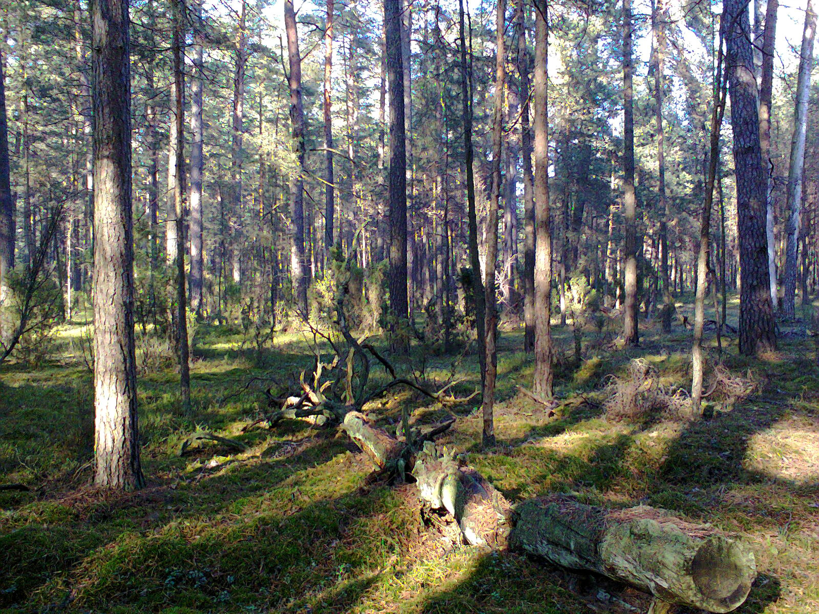
Sunlight filters through a dense pine forest with mossy ground and a fallen tree trunk in the foreground.
A view of the woodland habitat within Rezerwat przyrody Mingos.

Mingos Nature Reserve history and protected-area timeline

The Mingos Nature Reserve was formally established in 1971 through a legal notification published in the Polish Monitor (M.P. z 1971 r. Nr 53, poz. 346). Its creation followed the standard pattern of Polish forest reserves of that era, in which selected stands of representative forest types were placed under state protection for scientific and educational study.

The reserve's justification was rooted in the long-term decline of the original Puszcza Kurpiowska. Once a vast pine-dominated forest covering much of the Kurpie Plain, this woodland had been progressively reduced by logging, agricultural expansion, and settlement over the preceding centuries. By setting aside a 13.46-hectare fragment of the characteristic blueberry pine forest (bór brusznicowy), the 1971 designation ensured that at least a small benchmark of the historical Kurpie forest ecosystem would remain intact for future study and comparison.

Since its establishment, the reserve has continued to be administered within the framework of the Nowogród Forest District. A documented fire damaged part of the northeastern zone, roughly 14 hectares in effect, where it destroyed the shrub layer, leaving an open understory that still distinguishes that section of the reserve today.

Mingos Nature Reserve landscape and geographic character

The physical setting of Mingos is shaped by the Równina Kurpiowska, a broad and gently undulating lowland mesoregion in northeastern Mazovia. The landscape is dominated by sandy outwash and glacial deposits that produce well-drained, nutrient-poor soils, the conditions under which the characteristic Kurpie pine forests developed.

Within the reserve itself, the terrain is essentially flat to gently rolling, typical of the broader plain. The 13.46-hectare protected area forms a compact stand of mature pine forest, with no major watercourses or dramatic relief features. Instead, the visual character is defined by tall Scots pines, an open canopy, and a relatively continuous mat of low shrubs and mosses across the forest floor.

The northern and eastern margins of the reserve show the imprint of past disturbance, where a fire removed the shrub layer and left a more open understory profile. This creates a subtle internal mosaic, contrasting the older, structurally complete pine stands elsewhere in the reserve with the more open, early-succession character of the burned area.

Mingos Nature Reserve ecosystems, habitats, and plant life

Mingos Nature Reserve protects a narrowly defined community type: a dry pine forest known in Polish forestry classification as bór brusznicowy, or blueberry pine forest. This community is characterized by the dominance of Scots pine in the canopy, a sparse shrub layer, and a ground cover rich in ericaceous dwarf shrubs and mosses.

The vegetation is notably species-poor, with only 38 vascular plant and bryophyte species recorded in the reserve. This low diversity is itself an ecological signal, reflecting the acidic, sandy soils and the limited nutrient availability typical of the Kurpie Plain. Such communities are valued precisely because they represent a stable, well-preserved baseline of the regional pine forest type rather than a more diverse mixed woodland.

Within the reserve, the bryophyte layer is a particularly important structural component, documented to include species such as the shiny shaggy-moss (Hylocomium splendens, gajnik lśniący) and other typical dry-pine-forest mosses. Although modest in size, the reserve provides a continuous example of how the original Puszcza Kurpiowska functioned ecologically, and serves as a reference site for the bór brusznicowy community across the wider region.

Mingos Nature Reserve wildlife and species highlights

The source documentation for Mingos focuses on vegetation and forest structure rather than fauna, so the reserve's wildlife profile is best characterized as typical of dry pine woodlands on sandy Kurpie soils. The open canopy and dense mats of dwarf shrubs and mosses create habitat for species associated with coniferous forest interiors and forest edges.

The mosaic created by the past fire on the northeastern fringe adds structural variation, opening part of the canopy and producing early-succession habitats that are often attractive to birds and insects associated with disturbed pine forest. Such burned patches in otherwise uniform pine stands can support specialized assemblages of deadwood-dependent invertebrates and ground-nesting birds, even in very small reserves like Mingos.

Mingos Nature Reserve conservation status and protection priorities

The conservation importance of Mingos lies in its function as a preserved reference of the historical Puszcza Kurpiowska dry pine forest type. By protecting a stable example of the bór brusznicowy community on poor sandy soils, the reserve anchors regional understanding of how the original Kurpie pine forests were structured and how they may respond to disturbance.

The reserve's scientific and educational role is explicitly stated in its founding rationale, framing Mingos not as a large wilderness area but as a research benchmark. Its long-term value for monitoring shifts in understory composition, ground-layer dynamics, and post-fire recovery in pine forests makes it a small but informative component of Mazowieckie's protected-area network.

Mingos Nature Reserve cultural meaning and human context

The Mingos reserve lies within the historic cultural landscape of the Kurpie (Kurpiów) region, an area known for its distinctive folk traditions, forestry culture, and historically dense pine forests. The protection of fragments of Puszcza Kurpiowska connects directly to local identity, as the forest long shaped the livelihoods, customs, and material culture of communities such as those around Łyse.

While the reserve itself does not contain built heritage or active cultural sites, its existence reflects the broader 20th-century recognition that the once-extensive Kurpie Forest had become a cultural and ecological memory more than a living landscape, warranting the preservation of surviving fragments.

Top sights and standout views in Mingos Nature Reserve

Mingos Nature Reserve is a compact, ecologically focused forest reserve whose strength lies in its clear identity and scientific clarity rather than its size. Its single defining feature, the preserved bór brusznicowy pine community, makes it a useful benchmark for understanding the original character of the Kurpie Pine Forests.

The reserve also offers a visible case study in post-disturbance dynamics, given the fire-affected northeastern zone where the shrub layer was removed. Combined with its location within the Równina Kurpiowska and its integration into the Nowogród Forest District, Mingos stands out as a small but carefully chosen example of regional dry pine forest conservation in Poland.

Best time to visit Mingos Nature Reserve

Given its character as a forest reserve, Mingos is most rewarding in late spring through early autumn, when the canopy is fully leafed (in the case of deciduous elements) and ground-layer plants such as lily of the valley and clubmosses can be observed. The dry, sandy terrain is generally accessible on foot along forest paths during these months.

Summer visits highlight the open pine canopy and moss-rich ground layer, while early autumn can emphasize the blueberry and ericaceous shrubs that give the protected community its name. Winter visits remain possible but provide reduced visibility of the key understory features; visitors should be mindful that fire risk in dry pine stands is particularly relevant during late spring and summer periods.

Monthly climate preview

Measured monthly temperature ranges and precipitation patterns for Rezerwat przyrody Mingos

Rezerwat przyrody Mingos Climate Normals and Annual Temperature Rhythm

Representative point records for Rezerwat przyrody Mingos demonstrate long-term monthly temperature variations spanning sub-zero winter minimums to warm summer maximums alongside measured daily precipitation averages. Detailed monthly breakdowns provide deeper comparative context for examining annual meteorological trends across the protected coordinate.
Annual mean7 °C
-5 °C19 °C
Jan-5°
Feb-3°
Mar
Apr
May13°
Jun17°
Jul19°
Aug18°
Sep13°
Oct
Nov
Dec-3°
Warmest month
July

18.9 °C

Coolest month
January

-4.6 °C

Wettest month
July

2.5 mm/day

Driest month
March

1.4 mm/day

Park location guide

Geography guide, regional context, and park location map for Mingos Nature Reserve

Mingos Nature Reserve park geography, regions, and map view in Poland

Understand where Mingos Nature Reserve sits in Poland through a broader geographic reading of the surrounding landscape, nearby location context, and its mapped position within the national park landscape.

How Mingos Nature Reserve fits into Poland

Poland, officially the Republic of Poland, is a Central European country spanning from the Baltic Sea in the north to the Carpathian Mountains in the south. It borders Germany, Czech Republic, Slovakia, Ukraine, Belarus, Lithuania, and Kaliningrad Oblast. The country has a temperate climate, diverse landscapes, and is known for its rich history, cultural heritage, and strong economic position within the EU.

Wider geography shaping Mingos Nature Reserve in Poland

Poland occupies 312,696 km2 in Central Europe, extending from the Baltic Sea coast in the north to the Sudetes and Carpathian Mountains in the south. It borders Germany to the west, Czech Republic and Slovakia to the south, Ukraine and Belarus to the east, and Lithuania and Kaliningrad Oblast to the northeast. The landscape includes lowland plains, uplands, and mountain ranges.

Map view of Mingos Nature Reserve

Use this park location map to pinpoint Mingos Nature Reserve in Poland, understand its exact geographic position, and read its mapped placement within the surrounding landscape more clearly.

Pigeon | © OpenStreetMap contributors

Photographic records of dry pine forest habitats and lowland terrain

Visual Exploration of Rezerwat przyrody Mingos Landscapes and Scenery

Visual documentation captures the sandy terrain and mature Scots pine woodlands defining the protected landscape. Photographic records reveal ecological structure across the reserve and surrounding Kurpie Plain environments.

Sunlight filters through a dense pine forest with mossy ground and a fallen tree trunk in the foreground.

Park atlas

Compare nearby forest reserves and regional terrain across the Mazovia lowlands

Explore Other Parks Near Rezerwat przyrody Mingos and Surrounding Protected Landscapes

Browsing other parks near Rezerwat przyrody Mingos reveals the broader ecological patterns of the Kurpie Plain and surrounding lowland forest reserves. Comparing these protected landscapes provides valuable regional context for regional dry pine habitats and sandy outwash terrain.
A soft watercolor painting showing a green marshy landscape with tall grasses, calm water, and gentle rolling hills in the background.
Nature reserveWarmian-Masurian Voivodeship
About 29 km away#1 closest

North

Rezerwat przyrody Jezioro Nidzkie: Protected Area and Regional Landscape Geography

Mapping the forest and lake terrain of the Mazurian Plain

Examine the geographic characteristics of Rezerwat przyrody Jezioro Nidzkie, a protected nature reserve nestled within the Piska Forest. This profile tracks the spatial distribution of alder swamps, pine forests, and postglacial waters that create a distinct ecological mosaic across the Warmian-Masurian landscape.

Area
29.509 km²
Established
1972
Relief
Lowland
Climate
Temperate
A watercolor painting showing a soft, muted landscape of wetlands, grasses, and distant trees with a white background.
Nature reserveWarmian-Masurian Voivodeship
About 30 km away#2 closest

North

Rezerwat przyrody Jezioro Pogubie Wielkie Nature Reserve Geographic and Wetland Atlas

Mapping wetland habitats in the Warmian-Masurian Voivodeship region

Examine the protected boundaries and layered ecosystem of Rezerwat przyrody Jezioro Pogubie Wielkie. This reserve serves as an important refuge for water birds, defined by its shallow lake basin, charophyte meadows, and the distinctive forested island of Ostrów Wielki within the Pisz Forest complex.

Area
7.158 km²
Established
1971
Relief
Lowland
Scope
Terrestrial
Nature reserveMasovian Voivodeship
About 34 km away#3 closest

Southwest

Zachodniokurpiowskie Bory Sasankowe: Protected Forest Geography and Reserve Map

A study of dry pine habitats in the Masovian Voivodeship

The Zachodniokurpiowskie Bory Sasankowe nature reserve serves as an essential reference for continental pine forest ecosystems. By protecting the delicate interplay between sandy dune topographies and lichen-rich woodland floors, this site provides a rare window into the post-glacial geography of the Kurpie Plain.

Area
22.141 km²
Established
2018
Relief
Lowland
Climate
Temperate
Nature reservePodlaskie Voivodeship
About 39 km away#4 closest

Southeast

Rezerwat przyrody Dębowe Góry: Protected Sessile Oak Forest in Podlaskie Voivodeship

Ecologically intact lowland forest and rare plant habitat

Rezerwat przyrody Dębowe Góry stands as a protected sanctuary for light-loving sessile oak communities in Podlaskie Voivodeship. Its rolling lowland terrain and rich understory flora represent an essential fragment of Poland's natural woodland heritage, functioning as a key study area within the broader Czerwony Bór forest landscape context.

Area
0.993 km²
Established
2001
Relief
Lowland
Scope
Terrestrial
Protected areaWarmian-Masurian Voivodeship
About 46 km away#5 closest

West

Puszcza Napiwodzko-Ramucka Protected Forest and Glacial Geography in Northeast Poland

An expansive lowland wilderness featuring unique sinkhole terrain.

Spanning over 117,000 hectares, Puszcza Napiwodzko-Ramucka stands as a massive pine-dominated forest complex in the Warmian-Masurian Voivodeship. The terrain is a masterclass in glacial history, defined by sandr plains, moraine hills, and a dense network of post-glacial lakes. This protected area functions as a critical sanctuary for raptor species and large mammals, while its distinct geology, marked by active suffosion processes, distinguishes it as a key subject for landscape-level study.

Area
1,173.2 km²
Relief
Lowland
Climate
Temperate
Access
Access unknown
A pale, soft-focus watercolor illustration showing a horizontal landscape of rolling green hills, distant hills in shades of purple and grey, and groups of conifer trees.
Protected landscapeMasovian Voivodeship
About 52 km away#6 closest

South

Puszcza Biała Protected Landscape: Map and Geography of the Mazovian Lowland Forests

Extensive pine-dominated woodlands of Masovian Voivodeship

Puszcza Biała is a massive, continuous lowland forest in east-central Poland, characterized by its dominant Scots pine stands and post-glacial sandy soils. Positioned between the Bug and Narew rivers, this protected landscape provides a quiet, expansive green space that serves as an essential component of the regional natural geography of the Masovian Voivodeship.

Area
850 km²
Relief
Lowland
Scope
Terrestrial
Water
Major water bodies
Watercolor painting showing a wetland scene with reeds, patches of water, and trees under a light sky
National parkPodlaskie Voivodeship
About 54 km away#7 closest

East

Biebrza National Park: Protected Fenlands and River Basin Geography in Northeastern Poland

Tracing the largest lowland peat bog complex in the European landscape

Biebrza National Park serves as the premier protected wetland area in Poland, characterized by its vast, intact marshlands and the meandering Biebrza River valley. This geographic profile details the park's critical fen ecosystems, floodplain dynamics, and distinctive habitats that support diverse avian and mammalian populations within the Podlaskie region.

Area
592.23 km²
Established
1993
IUCN
II
Relief
Lowland
A watercolor painting of a flat wetland landscape with a winding river in the foreground, small clusters of trees, and rolling hills in the soft, distant background.
National parkPodlaskie Voivodeship
About 54 km away#8 closest

East

Biebrzański Park Narodowy: A Protected Wetland Landscape in Podlaskie Voivodeship, Poland

Mapped river valley and peatland geography.

Located in the northeast of Poland, Biebrzański Park Narodowy protects a sprawling, flat basin defined by the slow-meandering Biebrza River. This critical protected area encompasses rare peat bogs, floodplain meadows, and alder carrs, functioning as a vital refuge for wetland species within the broader Podlaskie Voivodeship landscape.

Area
592.23 km²
Established
1993
Visitors
23.2K annual
Relief
Lowland

Common questions about visiting, size, designation, and location context for Mingos Nature Reserve

Mingos Nature Reserve FAQs for park facts, access, geography, and protected area context

Find quick answers about Mingos Nature Reserve, including protected-area facts, park geography, trail and visitor context, and how the park fits into its surrounding country and regional landscape.
MoriAtlas Explorer

Continue Your Protected Areas Search Across the Global Atlas

Deepen your exploration by continuing the structured search for national parks and protected areas worldwide. Utilize the comprehensive filtering capabilities to compare different conservation landscapes and refine your understanding of global park geography. Discover more about the distribution and characteristics of protected natural areas.

Global natural geography