


Mori Atlas logo
Nature reserveRezerwat przyrody Mogielica

Examining the high elevation forest habitats and rocky summit landforms of a critical Carpathian sanctuary.

Rezerwat przyrody Mogielica: An Essential Protected Nature Reserve in the Beskid Wyspowy Range

Rezerwat przyrody Mogielica represents a vital conservation landscape at the highest peak of the Beskid Wyspowy range in southern Poland. This nature reserve protects a complex gradient of mountain ecosystems, ranging from beech and fir woodlands to rare upper mountain spruce forests. By mapping the northern slopes and rocky summit of this Carpathian landmark, the area provides a sanctuary for capercaillie and other boreal bird species within Województwo małopolskie.

CarpathiansBeskid Wyspowymountain reservecapercaillieupper-mountain spruce forestbeech-fir forest
A digital illustration of a mountainous landscape at sunset, featuring silhouetted thorny bushes with red berries in the foreground and a rolling green valley with a distant mountain range in the background.

Rezerwat przyrody Mogielica

Nature reserve

Park overview

Structured park overview, official facts, and landscape profile for Rezerwat przyrody Mogielica

Rezerwat przyrody Mogielica park facts, protected area profile, and essential visitor context

Review the core facts for Rezerwat przyrody Mogielica, including designation, size, terrain, visitor scale, habitats, and operating context in one park-focused overview.

About Rezerwat przyrody Mogielica

Rezerwat przyrody Mogielica is a Carpathian forest and mountain reserve whose character is shaped by both altitude and isolation. It occupies the top of Mogielica, the highest peak of the Beskid Wyspowy, a distinct, island-like range in the western part of the Polish Carpathians whose individual massifs stand out from the surrounding landscape. At the summit, elevation reaches about 1171 meters, and the reserve covers the upper part of the peak, including the north-facing slopes that hold the most valuable forest communities.

The protected landscape is dominated by Carpathian beech and fir forest lower down, transitioning into a natural stand of upper-mountain spruce forest around the summit. This combination gives the reserve a vertical ecological gradient that is unusual in this part of Poland and supports a suite of species associated with mature, undisturbed mountain woodlands. Rock outcrops, erosional landforms, and tectonic features near the summit add a geological dimension to the protection rationale and contribute to the mixed classification of the reserve as both faunistic and biocenotic.

Administratively, the reserve sits in Lesser Poland voivodeship, Limanowa county, spanning Gmina Słopnice (the village of Słopnice) and Gmina Dobra (the villages of Chyszówki and Półrzeczki). It is supervised by the Regional Director of Environmental Protection in Kraków, with Limanowa Forest District handling practical forest management. In national ecological terms, the reserve represents one of the southernmost surviving strongholds of capercaillie in Poland and a key piece of habitat for other rare boreal and mountain bird species, including several specialist woodpeckers and owls whose populations have contracted severely elsewhere in the country.

Quick facts and research context for Rezerwat przyrody Mogielica

Rezerwat przyrody Mogielica lies on the summit and northern slopes of Mogielica (1171 m), the highest peak of the Beskid Wyspowy mountain range in the Lesser Poland voivodeship, within Limanowa county at the border of Gmina Słopnice and Gmina Dobra. It covers about 50 hectares and is surrounded by a buffer zone of around 91 hectares, with partial protection status. The reserve was created on 12 March 2011 by order of the Regional Director of Environmental Protection in Kraków, fulfilling a conservation goal centered on capercaillie and its biotope, together with other rare birds, natural forest habitats, and summit rock formations. Limanowa Forest District manages the surrounding forest, and the area sits near, but is not fully included in, the Natura 2000 site Ostoja Gorczańska (PLH120018).

Protection and recognition

Documented terrestrial protection scope and administrative designation details

Rezerwat przyrody Mogielica Protection Status and International Recognition

Rezerwat przyrody Mogielica maintains a documented terrestrial protection scope within the regional conservation network. Administrative records assemble official designation parameters and international recognition data for the protected area.

Protection details

Protection scope
Terrestrial
Transboundary protection
No
Buffer area
0.91 km²
Park context

Deeper park guide and search-rich context for Rezerwat przyrody Mogielica

Rezerwat przyrody Mogielica history, landscape, wildlife, and travel context

Explore Rezerwat przyrody Mogielica through its history, landscape character, ecosystems, wildlife, conservation priorities, cultural context, and seasonal travel timing in a structured park guide built for atlas discovery and search intent.

Why Rezerwat przyrody Mogielica stands out

The reserve is best known as one of the few strongholds of the capercaillie in the Polish Carpathians. The upper forest of Mogielica continues to host this large forest grouse, which has disappeared from most of its former lowland and foothill range. The reserve is also notable for a natural patch of upper-mountain spruce forest, a rare boreal-type habitat in the Beskid Wyspowy, and for combining bird-focused protection with the safeguarding of geological and erosional landforms around the rocky summit of Mogielica.
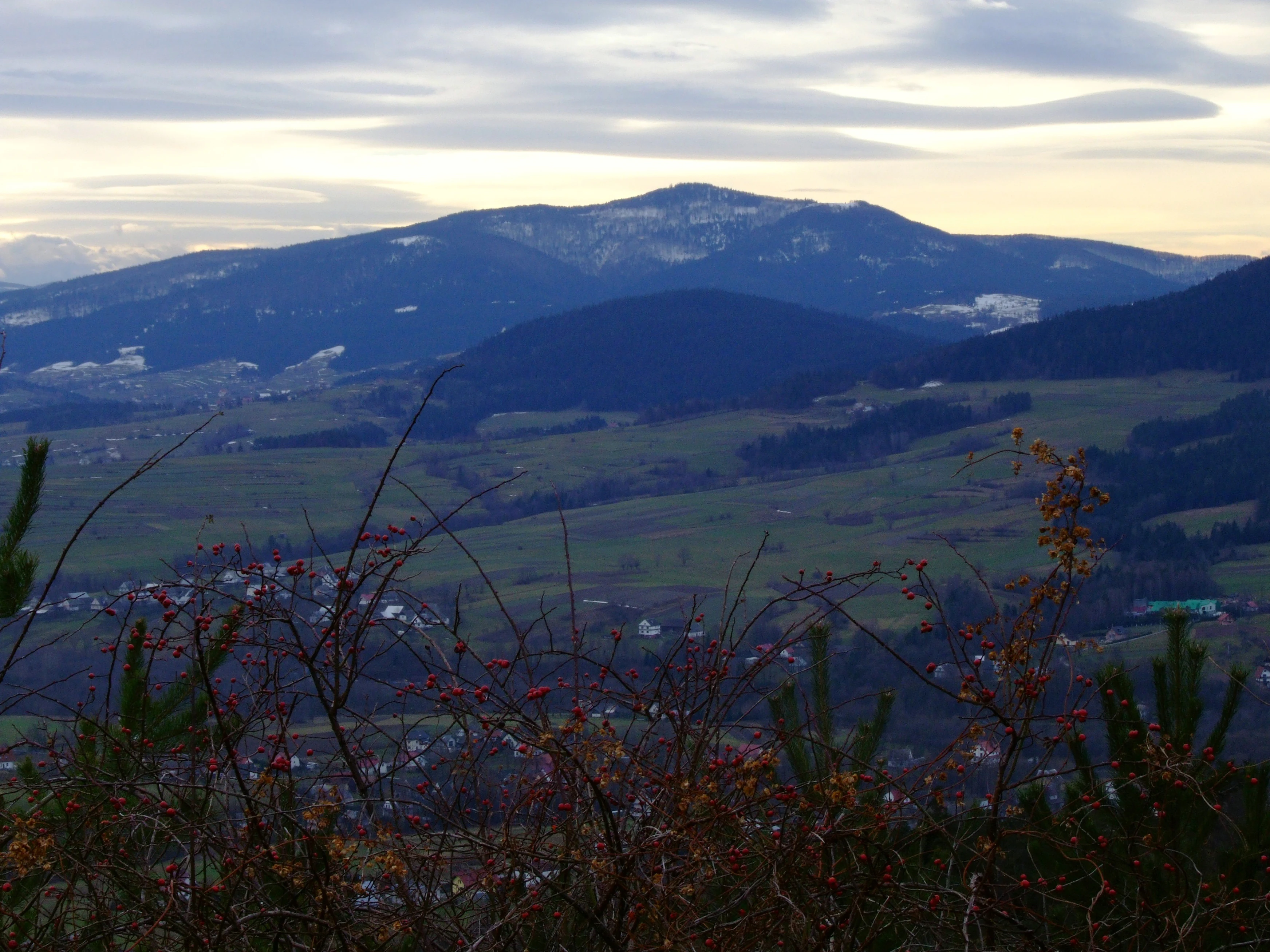
Panoramic landscape view featuring a prominent mountain ridge with forested slopes and scattered patches of snow under a cloudy sky.
A wide view of Mount Mogielica and surrounding landscape in the Beskid Wyspowy range.

Rezerwat przyrody Mogielica history and protected-area timeline

The history of Rezerwat przyrody Mogielica is closely tied to a local development conflict. Pressure to protect the area began in 2005, when Gmina Słopnice initiated plans for a ski resort complex on the northern slopes of Mogielica, with the planned upper station located directly within the local capercaillie stronghold. Conservationists, especially members of the Małopolska chapter of the Polish Society for the Protection of Birds (Towarzystwo Przyrodnicze Bocian), responded with a detailed natural inventory of the Mogielica summit dome.

That inventory confirmed the exceptional ornithological value of the area, documented breeding populations of several nationally rare bird species, and demonstrated the presence of large predators in the surrounding forest. With the support of Limanowa Forest District, which voluntarily halted logging in the proposed reserve area from 2005 onward, ecological organizations pushed for formal protection. The reserve was eventually established on 12 March 2011, based on order 37/10 issued by the Regional Director of Environmental Protection in Kraków on 30 December 2010, and was officially published on 25 February 2011.

Despite this success, conservationists regard the reserve as only a partial victory. They argue that the protected area is too small and that its boundary represents a compromise between conservation goals and municipal interests. In particular, the construction of a viewing tower on the summit of Mogielica has increased tourist pressure on the reserve, while only a small southern portion of the site currently lies within the Natura 2000 habitat area Ostoja Gorczańska (PLH120018).

Rezerwat przyrody Mogielica landscape and geographic character

The reserve sits at the top of the Beskid Wyspowy, a Carpathian range characterized by separated, dome-shaped peaks that rise individually out of the surrounding foothills. Within this island-like setting, Mogielica stands at 1171 meters and forms the highest point of the entire group. Its summit is rounded and rocky, with erosional and tectonic features that have shaped small cliffs, weathered forms, and exposed stone near the very top, which is why the reserve is partly classified as a geological and soil protection type.

The slopes below the summit fall steeply to the north, where the reserve boundary is drawn, while other directions slope more gently into neighboring valleys. Lower elevations around the reserve are typical of the western Carpathians, with forest-covered ridges, scattered Carpathian settlements, and traditionally managed mountain pastures, though the protected area itself focuses on the upper forest belt and rocky summit zone.

Rezerwat przyrody Mogielica ecosystems, habitats, and plant life

Ecologically, Rezerwat przyrody Mogielica sits at the transition between two major Carpathian forest types. Lower and middle slopes are clothed in mixed Carpathian beech and fir forest, a community typical of the western Carpathians that thrives in cool, humid montane conditions. Above this, hugging the summit area, lies a natural patch of upper-mountain spruce forest, a boreal-like habitat dominated by Norway spruce and characteristic of Poland's highest mountain ranges. This combination creates a vertical zonation in which forest composition, microclimate, and wildlife communities change significantly over a short distance.

The reserve is formally classified as a forest and boreal-type ecosystem protection area, reflecting the dominance of upper-mountain spruce and submontane forests. It is also classified as a biocenotic and physiocenotic reserve, recognizing the value of the natural forest communities and the underlying landforms. Together, these classifications emphasize that the value of the site lies not just in individual species, but in the intact structure and continuity of the upper forest ecosystem itself.

Rezerwat przyrody Mogielica wildlife and species highlights

The wildlife profile of the reserve is dominated by the capercaillie (Tetrao urogallus), the species around which the entire protection regime was designed. Capercaillie is one of the rarest and most threatened large birds in Poland, dependent on large, undisturbed, and structurally diverse coniferous and mixed forests. Mogielica is among the few places in the Polish Carpathians where this species continues to maintain a viable population, and the reserve was specifically created to safeguard its nesting habitat.

In addition to capercaillie, the forest here supports an unusually rich assemblage of rare and range-restricted breeding birds. Documented species include three-toed woodpecker, white-backed woodpecker, Eurasian pygmy owl, Tengmalm's owl, ring ouzel, common redpoll, and Eurasian jay, several of which are at the southern or western edge of their ecological range in Poland. The wider forest landscape also falls within home ranges or hunting territories of Ural owl, Eurasian eagle-owl, lesser spotted eagle, and golden eagle, while mammals in the broader Mogielica forest complex include resident wolves and lynx, with brown bears appearing occasionally as visitors from the neighboring Carpathian ranges.

Rezerwat przyrody Mogielica conservation status and protection priorities

From a conservation standpoint, the reserve is exceptionally significant despite its small size. It preserves one of the last functional capercaillie strongholds in the Polish Carpathians outside the better-known Tatra and Bieszczady populations, and the surrounding forest supports an unusually complete community of large forest predators and boreal specialists. Because capercaillie depends on landscape-scale habitat continuity rather than small fragments alone, conservationists regard the site as ecologically valuable but legally incomplete.

This is why many in the Polish conservation community continue to advocate for the reserve's boundary to be enlarged and for the area to be formally integrated into the Natura 2000 network as an extension of the existing Ostoja Gorczańska PLH120018 habitat site, of which only a small southern fragment currently overlaps the reserve. The reserve's mixed protection type, combined with its capercaillie orientation, its boreal forest stand, and its geological features, gives it a layered conservation profile that covers forest biodiversity, birdlife, and landform preservation in a single relatively compact unit.

Rezerwat przyrody Mogielica cultural meaning and human context

The reserve lies in a region with a long tradition of Carpathian mountain use, including seasonal pastoralism, forestry, and small-scale agriculture in dispersed mountain villages such as Słopnice, Chyszówki, and Półrzeczki. Whereas lowland Slovakia and the Tatra region are often associated with strongly developed mountain tourism infrastructure, the Mogielica area has historically remained quieter, with forests managed by Limanowa Forest District and local economies tied to agriculture and small-scale timber use. The reserve's creation in 2011 marks a shift in which local municipalities, the forestry administration, and conservation NGOs negotiated to balance community interests with habitat protection, a process that is itself part of the cultural identity of the site.

Top sights and standout views in Rezerwat przyrody Mogielica

The reserve's main highlights revolve around its combination of capercaillie conservation, boreal forest preservation, and summit-level scenery. Visitors interested in wildlife value the area as one of Poland's most important sites for capercaillie and a suite of other rare boreal and montane birds, including three-toed and white-backed woodpeckers, pygmy and Tengmalm's owls, and ring ouzel. Ecologically, the natural spruce stand at the top of Mogielica and the surrounding beech-fir forest give the reserve one of the most complete montane forest gradients in the Beskid Wyspowy. Geologically, the rocky and eroded summit of Mogielica adds a landform dimension to the otherwise wildlife-focused protection. Together, these features make the reserve a compact but unusually layered Carpathian conservation site.

Best time to visit Rezerwat przyrody Mogielica

The practical character of a visit to the Mogielica area changes with the seasons. Spring and early summer bring active bird song and the best chance of encountering breeding specialties such as woodpeckers, owls, and ring ouzel in vocal display, though capercaillie observation is strictly seasonal and often restricted to early morning at specific times in spring. Late spring and early summer also offer the freshest forest conditions and the most pleasant hiking weather, with the summit accessible without deep snow.

Autumn can be attractive for forest atmosphere and the chance to hear rutting deer in the wider area, while winter brings deep snow and the best cross-country and touring skiing conditions on the surrounding open slopes; access to the reserve itself, however, is limited by snow cover and potential trail difficulty. Because capercaillie and other wildlife are easily disturbed, especially in winter and during the breeding season, the area is best approached as a quiet hiking and nature destination rather than a heavily visited viewpoint, and visitors should follow seasonal guidance from local conservation authorities where available.


Monthly climate preview

Long-term representative coordinate measurements for monthly temperature and precipitation variation

Rezerwat przyrody Mogielica Climate Normals and Annual Temperature Rhythm

Rezerwat przyrody Mogielica records measured monthly temperature values ranging from deep winter minimums to warm summer maximums alongside steady daily precipitation rates. Examining the full twelve-month profile provides complete historical climate normals and detailed monthly comparison data.
Annual mean6 °C
-5 °C17 °C
Jan-5°
Feb-4°
Mar
Apr
May11°
Jun15°
Jul17°
Aug17°
Sep12°
Oct
Nov
Dec-4°
Warmest month
July

16.7 °C

Coolest month
January

-4.9 °C

Wettest month
July

4.4 mm/day

Driest month
December

1.7 mm/day

Park location guide

Geography guide, regional context, and park location map for Rezerwat przyrody Mogielica

Rezerwat przyrody Mogielica park geography, regions, and map view in Poland

Understand where Rezerwat przyrody Mogielica sits in Poland through a broader geographic reading of the surrounding landscape, nearby location context, and its mapped position within the national park landscape.

How Rezerwat przyrody Mogielica fits into Poland

Poland, officially the Republic of Poland, is a Central European country spanning from the Baltic Sea in the north to the Carpathian Mountains in the south. It borders Germany, Czech Republic, Slovakia, Ukraine, Belarus, Lithuania, and Kaliningrad Oblast. The country has a temperate climate, diverse landscapes, and is known for its rich history, cultural heritage, and strong economic position within the EU.

Wider geography shaping Rezerwat przyrody Mogielica in Poland

Poland occupies 312,696 km2 in Central Europe, extending from the Baltic Sea coast in the north to the Sudetes and Carpathian Mountains in the south. It borders Germany to the west, Czech Republic and Slovakia to the south, Ukraine and Belarus to the east, and Lithuania and Kaliningrad Oblast to the northeast. The landscape includes lowland plains, uplands, and mountain ranges.

Map view of Rezerwat przyrody Mogielica

Use this park location map to pinpoint Rezerwat przyrody Mogielica in Poland, understand its exact geographic position, and read its mapped placement within the surrounding landscape more clearly.

Pigeon | © OpenStreetMap contributors

Location context for Rezerwat przyrody Mogielica

Województwo małopolskie

Visualizing the high elevation forests and rocky summit terrain of Beskid Wyspowy

Rezerwat przyrody Mogielica Landscape and Scenery Photography

Examine detailed visual documentation of Rezerwat przyrody Mogielica, capturing its high-altitude spruce stands and protected wildlife habitats. Photographic records illustrate the rugged summit terrain and forested northern slopes that define this Carpathian mountain reserve.

Panoramic landscape view featuring a prominent mountain ridge with forested slopes and scattered patches of snow under a cloudy sky.

Park atlas

Compare regional mountain reserves and forest habitats across the surrounding region

Explore Parks Near Rezerwat przyrody Mogielica and Related Protected Landscapes

Trace connected protected areas and mountain reserves situated within the wider Carpathian region. Compare adjacent forest habitats and protected landscapes to understand regional conservation geography beyond Rezerwat przyrody Mogielica.
Nature reserveLesser Poland Voivodeship
About 0.6 km away#1 closest

Southwest

Ostoja Gorczańska: Protected Area Mapping and Carpathian Mountain Geography in Lesser Poland

Ecological corridors across the Gorce and Beskid Wyspowy ranges

Covering nearly 18,000 hectares, Ostoja Gorczańska represents a significant biodiversity reservoir in the Polish Carpathians. The site integrates multiple protection frameworks, safeguarding varied habitats from subalpine grasslands to dense montane forests and peatland depressions. Use this resource to examine the structural connectivity of these mountain units and the expansive wilderness corridors found within the Lesser Poland Voivodeship.

Area
179.979 km²
Established
2008
Relief
Mountain
Climate
Temperate
Nature reserveLesser Poland Voivodeship
About 3.9 km away#2 closest

North

Uroczysko Łopień Nature Reserve: Geography and Protected Habitat Mapping

Beskid Wyspowy mountain landscape and karst cave systems

Uroczysko Łopień represents a concentrated protected landscape within the Beskid Wyspowy, defined by its complex geology, primeval beech forests, and essential bat hibernation caves. The reserve showcases a remarkable density of micro-habitats, including raised peat bogs and sandstone rock formations, providing an essential study in Carpathian mountain conservation geography.

Area
0.445 km²
Relief
Mountain
Climate
Temperate
Access
Highly restricted
Protected areaLesser Poland Voivodeship
About 5.8 km away#3 closest

Southeast

Środkowy Dunajec z dopływami: Protected River Habitats and Carpathian Foothills Geography

Exploring the river corridor and riparian ecosystems of southern Poland

Spanning 755 hectares across four connected enclaves, Środkowy Dunajec z dopływami protects the vital riverine systems of the middle Dunajec and its tributaries. This site offers a unique look at the fluvial processes and biodiversity of Carpathian mountain streams, showcasing diverse habitat structures from pioneer gravel banks to mature riparian forests.

Area
7.56 km²
Relief
Upland
Scope
Terrestrial
Water
Major water bodies
Watercolor painting showing rolling green hills, forests, and distant mountains under a pale sky
National parkLesser Poland Voivodeship
About 7.7 km away#4 closest

Southwest

Gorce National Park: A Comprehensive Geographic Profile and Protected Area Analysis

Mountain meadows and Carpathian forest landscapes in southern Poland

Gorce National Park preserves an essential segment of the Western Beskids, offering a look into the region's arched ridges and forested terrain. The area serves as a critical protected landscape featuring significant biodiversity, ancient woodland, and open mountain meadows that distinguish the local geography of the Lesser Poland Voivodeship.

Area
70.3 km²
Established
1981
IUCN
II
Visitors
80K annual
A horizontal watercolor illustration depicting rolling, layered mountains in shades of purple, red, and soft green, with a foreground of green evergreen forest silhouettes against a white background.
National parkLesser Poland Voivodeship
About 7.7 km away#5 closest

Southwest

Gorczański Park Narodowy: Protected Mountain Geography in Lesser Poland Voivodeship

Carpathian forest and mountain clearing atlas

Gorczański Park Narodowy serves as a critical protected landscape in the Polish Carpathians. This atlas entry details the park's topography, including the dominant Turbacz massif, extensive forest corridors, and the ecological significance of its seepage meadows and high-altitude grasslands.

Area
70.3 km²
Established
1981
Visitors
92K annual
Relief
Mountain
Nature reserveLesser Poland Voivodeship
About 9.7 km away#6 closest

Northwest

Łąki koło Kasiny Wielkiej: Protected Meadow Habitats in Lesser Poland Voivodeship

Ecological mapping of traditional Carpathian grassland ecosystems.

Łąki koło Kasiny Wielkiej is a specialized nature reserve in the Beskid Wyspowy range, protecting fragmented semi-natural meadows that represent essential habitat types within the European Natura 2000 network. By analyzing the site boundaries and regional landscape context within Lesser Poland Voivodeship, this entry provides insight into how low-intensity farming preserves distinctive grassland flora and terrain structure in the Carpathian foothills.

Area
0.244 km²
Established
2011
Relief
Mountain
Climate
Temperate
Protected areaLesser Poland Voivodeship
About 17 km away#7 closest

West

Raba z Mszanką Protected Area: Atlas of Carpathian Riverine and Riparian Landscapes

Geographic map and habitat overview for southern Poland.

Raba z Mszanką serves as a significant protected corridor within the Lesser Poland Voivodeship. The site illustrates the ecological gradient of mountain stream environments, featuring shifting gravel bars, willow shrublands, and floodplain forests. This entry provides context on the riverine geography, including its role in sustaining populations of the Mediterranean barbel within the Carpathian foothills.

Area
2.493 km²
Scope
Terrestrial
Water
Major water bodies
Protected areaLesser Poland Voivodeship
About 18 km away#8 closest

Southeast

Ostoja Popradzka: Mapped Protected Landscapes and Geographic Context in Southern Poland

A core conservation site within the Beskid Sadecki mountain range

Spanning extensive river valleys and alpine meadows, Ostoja Popradzka serves as a primary habitat network in the Polish Carpathians. This entry details its layered geography, including protected forest reserves, karst cave systems, and essential corridors for large carnivores, framed within the administrative boundaries of the Lesser Poland Voivodeship.

Area
579.31 km²
Established
2008
Relief
Mountain
Scope
Terrestrial

Common questions about visiting, size, designation, and location context for Rezerwat przyrody Mogielica

Rezerwat przyrody Mogielica FAQs for park facts, access, geography, and protected area context

Find quick answers about Rezerwat przyrody Mogielica, including protected-area facts, park geography, trail and visitor context, and how the park fits into its surrounding country and regional landscape.
MoriAtlas Explorer

Continue Your Protected Areas Search Across the Global Atlas

Deepen your exploration by continuing the structured search for national parks and protected areas worldwide. Utilize the comprehensive filtering capabilities to compare different conservation landscapes and refine your understanding of global park geography. Discover more about the distribution and characteristics of protected natural areas.

Global natural geography
